
Crotalus oreganus lutosus
Encyclopedia
- Common names: Great Basin rattlesnake.
Crotalus oreganus lutosus is a venomous
Venomous snake
"Poisonous snake" redirects here. For true poisonous snakes, see Rhabdophis.Venomous snakes are snakes which have venom glands and specialized teeth for the injection of venom...
pitviper
Crotalinae
The Crotalinae, commonly known as "pit vipers" or crotaline snakes, are a subfamily of venomous vipers found in Asia and the Americas. They are distinguished by the presence of a heat-sensing pit organ located between the eye and the nostril on either side of the head...
subspecies
Subspecies
Subspecies in biological classification, is either a taxonomic rank subordinate to species, ora taxonomic unit in that rank . A subspecies cannot be recognized in isolation: a species will either be recognized as having no subspecies at all or two or more, never just one...
found in the Great Basin
Great Basin
The Great Basin is the largest area of contiguous endorheic watersheds in North America and is noted for its arid conditions and Basin and Range topography that varies from the North American low point at Badwater Basin to the highest point of the contiguous United States, less than away at the...
region of the United States
United States
The United States of America is a federal constitutional republic comprising fifty states and a federal district...
.
Description
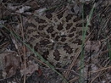
Adult specimens are 66-121 cm in length, but rarely exceed an overall length of 1 m. The males grow larger than the females.On the subject of scalation, one of the more distinctive characteristics of this subspecies is that it has three or more internasal scales
Internasal scales
In snakes, the internasal scales are those on top of the head between the scales that surround the nostrils. They are usually paired and situated just behind the rostral....
-- something that it has in common with C. viridis
Crotalus viridis
Crotalus viridis is a venomous pitviper species native to the western United States, southwestern Canada, and northern Mexico. Currently, nine subspecies are recognized, including the nominate subspecies described here.-Description:...
.
The color pattern usually consists of a buff, pale gray, pale brown, olive brown or yellowish brown ground color, overlaid with a series of 32-49 dorsal blotches. These blotches are dark brown to black in color, with pale centers and pale borders, and are often irregular in shape and wider than they are long. There is also a series of lateral blotches that are indistinct anteriorly, but become more distinct posteriorly and eventually merge with the dorsal blotches to form crossbands. Older specimens either have sometimes have a faded pattern, or they may have uniformly black blotches, with the dorsum of the head also being black.
Geographic range
The United StatesUnited States
The United States of America is a federal constitutional republic comprising fifty states and a federal district...
in the Great Basin
Great Basin
The Great Basin is the largest area of contiguous endorheic watersheds in North America and is noted for its arid conditions and Basin and Range topography that varies from the North American low point at Badwater Basin to the highest point of the contiguous United States, less than away at the...
region. Its range includes Idaho
Idaho
Idaho is a state in the Rocky Mountain area of the United States. The state's largest city and capital is Boise. Residents are called "Idahoans". Idaho was admitted to the Union on July 3, 1890, as the 43rd state....
south of lat. 44° North, Utah
Utah
Utah is a state in the Western United States. It was the 45th state to join the Union, on January 4, 1896. Approximately 80% of Utah's 2,763,885 people live along the Wasatch Front, centering on Salt Lake City. This leaves vast expanses of the state nearly uninhabited, making the population the...
west of long. 111° West, Arizona
Arizona
Arizona ; is a state located in the southwestern region of the United States. It is also part of the western United States and the mountain west. The capital and largest city is Phoenix...
west and north of the Colorado River
Colorado River
The Colorado River , is a river in the Southwestern United States and northwestern Mexico, approximately long, draining a part of the arid regions on the western slope of the Rocky Mountains. The watershed of the Colorado River covers in parts of seven U.S. states and two Mexican states...
as well as the north rim of the Grand Canyon
Grand Canyon
The Grand Canyon is a steep-sided canyon carved by the Colorado River in the United States in the state of Arizona. It is largely contained within the Grand Canyon National Park, the 15th national park in the United States...
, the entire state of Nevada
Nevada
Nevada is a state in the western, mountain west, and southwestern regions of the United States. With an area of and a population of about 2.7 million, it is the 7th-largest and 35th-most populous state. Over two-thirds of Nevada's people live in the Las Vegas metropolitan area, which contains its...
(excluding Esmeralda
Esmeralda County, Nevada
Esmeralda County is a county in the west of U.S. state of Nevada. Its county seat is Goldfield. Its 2000 census population was officially 971, making its population density 0.1045 inhabitants/km² , the second-lowest of any county-equivalent outside of Alaska. As of 2010, the population had...
, Nye
Nye County, Nevada
-National protected areas:* Ash Meadows National Wildlife Refuge* Death Valley National Park * Humboldt-Toiyabe National Forest * Spring Mountains National Recreation Area -Demographics:...
and Clark
Clark County, Nevada
-Demographics:As of the census of 2000, there were 1,375,765 people, 512,253 households, and 339,693 families residing within the MSA. The racial makeup of the MSA was 71.6% White , 9.1% Black, 5.7% Asian, 0.8% American Indian and 12.8% of other or mixed race. 22.0% were Hispanic of any race...
counties), California
California
California is a state located on the West Coast of the United States. It is by far the most populous U.S. state, and the third-largest by land area...
east of the Sierra Nevada from Lower Klamath Lake
Lower Klamath Lake
Lower Klamath Lake is a lake in Siskiyou County, California, that currently serves to hold overflow water for irrigation. At one time it was connected to Upper Klamath Lake....
south to below Lake Mono, Oregon
Oregon
Oregon is a state in the Pacific Northwest region of the United States. It is located on the Pacific coast, with Washington to the north, California to the south, Nevada on the southeast and Idaho to the east. The Columbia and Snake rivers delineate much of Oregon's northern and eastern...
south and east of the line Upper Klamath Lake
Upper Klamath Lake
Upper Klamath Lake is a large, shallow freshwater lake east of the Cascade Range in south central Oregon in the United States. The largest freshwater body in Oregon, it is approximately 20 mi long and 8 mi wide and extends northwest from the city of Klamath Falls...
-Fort Rock-Burns
Burns, Oregon
Burns is a city in and the county seat of Harney County, Oregon, United States. As of the 2010 census the population was 2,806.-History:Burns was established in the early 1880s and incorporated upon Harney county's creation in 1889...
-Council
Council, Idaho
Council is a city in and the county seat of Adams County, Idaho, United States. The population was 839 at the 2010 census.-Geography:Council is located at ....
(Idaho
Idaho
Idaho is a state in the Rocky Mountain area of the United States. The state's largest city and capital is Boise. Residents are called "Idahoans". Idaho was admitted to the Union on July 3, 1890, as the 43rd state....
). The type locality is "10 miles northwest of Abraham on the Road to Joy, Millard County, Utah
Millard County, Utah
Millard County is a county located in the U.S. state of Utah. In 2010, its population was 12,420. It was named for Millard Fillmore, thirteenth President of the United States. Its county seat is Fillmore and the largest city is Delta.-Geography:...
."
Habitat
Inhabits the dry and barren areas of the Great BasinGreat Basin
The Great Basin is the largest area of contiguous endorheic watersheds in North America and is noted for its arid conditions and Basin and Range topography that varies from the North American low point at Badwater Basin to the highest point of the contiguous United States, less than away at the...
region, being found on hills, summits and old lake benches. They are said to prefer southern exposures among rocks and boulders on hillsides and buttes, low foothills, mountainsides, open deserts, alfalfa fields and valley floors.
External links
- Crotalus oreganus lutosus - Great Basin Rattlesnake at California Herps. Accessed 19 June 2007.