

Coyote Hills Regional Park
Encyclopedia
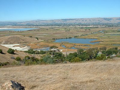
Regional park
Regional park is a term used for an area of land preserved on account of its natural beauty, historic interest, recreational use or other reason, and under the administration of a form of local government.-Definition:...
encompassing nearly 978 acres of land and administered by the East Bay Regional Park District
East Bay Regional Park District
The East Bay Regional Park District is a special district operating in Alameda County and Contra Costa County, California, within the East Bay area of the San Francisco Bay Area...
. The park, which was dedicated to public use in 1967, is located in Fremont
Fremont, California
Fremont is a city in Alameda County, California. It was incorporated on January 23, 1956, from the merger of five smaller communities: Centerville, Niles, Irvington, Mission San Jose, and Warm Springs...
, California
California
California is a state located on the West Coast of the United States. It is by far the most populous U.S. state, and the third-largest by land area...
, on the southeast shore of the San Francisco Bay
San Francisco Bay
San Francisco Bay is a shallow, productive estuary through which water draining from approximately forty percent of California, flowing in the Sacramento and San Joaquin rivers from the Sierra Nevada mountains, enters the Pacific Ocean...
. The Coyote Hills themselves are a small range of hills at the edge of the bay; though not reaching any great height, they afford tremendous views of the bay, three of the trans-bay bridges (Dumbarton Bridge
Dumbarton Bridge (California)
The Dumbarton Bridge is the southernmost of the highway bridges that span the San Francisco Bay in California. Carrying over 81,000 vehicles daily, it is also the shortest bridge across San Francisco Bay at 1.63 miles...
, San Mateo Bridge, and the Bay Bridge), the cities of San Francisco
San Francisco, California
San Francisco , officially the City and County of San Francisco, is the financial, cultural, and transportation center of the San Francisco Bay Area, a region of 7.15 million people which includes San Jose and Oakland...
and Oakland
Oakland, California
Oakland is a major West Coast port city on San Francisco Bay in the U.S. state of California. It is the eighth-largest city in the state with a 2010 population of 390,724...
, the Peninsula Range of the Santa Cruz Mountains
Santa Cruz Mountains
The Santa Cruz Mountains, part of the Pacific Coast Ranges, are a mountain range in central California, United States. They form a ridge along the San Francisco Peninsula, south of San Francisco, separating the Pacific Ocean from San Francisco Bay and the Santa Clara Valley, and continuing south,...
and Mount Tamalpais
Mount Tamalpais
Mount Tamalpais is a peak in Marin County, California, United States, often considered symbolic of Marin County. Much of Mount Tamalpais is protected within public lands such as Mount Tamalpais State Park and the Mount Tamalpais Watershed.-Geography:...
. In addition to the hills themselves, the park encloses a substantial area of wetland
Wetland
A wetland is an area of land whose soil is saturated with water either permanently or seasonally. Wetlands are categorised by their characteristic vegetation, which is adapted to these unique soil conditions....
s.
There are a number of archaeological
Archaeology
Archaeology, or archeology , is the study of human society, primarily through the recovery and analysis of the material culture and environmental data that they have left behind, which includes artifacts, architecture, biofacts and cultural landscapes...
sites within the park, preserving evidence of habitation by Native Americans
Native Americans in the United States
Native Americans in the United States are the indigenous peoples in North America within the boundaries of the present-day continental United States, parts of Alaska, and the island state of Hawaii. They are composed of numerous, distinct tribes, states, and ethnic groups, many of which survive as...
of the Ohlone
Ohlone
The Ohlone people, also known as the Costanoan, are a Native American people of the central California coast. When Spanish explorers and missionaries arrived in the late 18th century, the Ohlone inhabited the area along the coast from San Francisco Bay through Monterey Bay to the lower Salinas Valley...
group of tribes, including shellmounds. Access to these sites is not allowed for casual visitors, but they can be visited by arrangement.
There is a substantial network of hiking
Hiking
Hiking is an outdoor activity which consists of walking in natural environments, often in mountainous or other scenic terrain. People often hike on hiking trails. It is such a popular activity that there are numerous hiking organizations worldwide. The health benefits of different types of hiking...
trails in the park, most of them also available to equestrians, and 3.5 miles (5.6 km) to cyclists
Cycling
Cycling, also called bicycling or biking, is the use of bicycles for transport, recreation, or for sport. Persons engaged in cycling are cyclists or bicyclists...
. Most of the trails are wide fireroads that go around the hills and the marshes, and one fireroad that runs north-south through the hills ridge. There are few narrow trails which are off limits to bikers and equestrians. These trails connect to others in the east bay, and the San Francisco Bay Trail
San Francisco Bay Trail
The San Francisco Bay Trail is a bicycle and pedestrian trail that will eventually allow continuous travel around the shoreline of San Francisco Bay. As of 2011, approximately 310 miles of trail have been completed...
passes through the park. Cross country
Cross country running
Cross country running is a sport in which people run a race on open-air courses over natural terrain. The course, typically long, may include surfaces of grass and earth, pass through woodlands and open country, and include hills, flat ground and sometimes gravel road...
meets for local schools are held occasionally in the park. The waters to the south and west of the park form part of the San Francisco Bay National Wildlife Refuge, and a great deal of wildlife can be seen from the park trails.
History
Coyote Hills is home to the remnants of a large Project NikeProject Nike
Project Nike was a U.S. Army project, proposed in May 1945 by Bell Laboratories, to develop a line-of-sight anti-aircraft missile system. The project delivered the United States' first operational anti-aircraft missile system, the Nike Ajax, in 1953...
missile base. It has intact facilities that are in disrepair and some still in place are used as radio transmission & microwave antenna stations. Guard stations are still visible throughout the park.
After the NIKE Missile Base was decommissioned, the Stanford Research Institute
SRI International
SRI International , founded as Stanford Research Institute, is one of the world's largest contract research institutes. Based in Menlo Park, California, the trustees of Stanford University established it in 1946 as a center of innovation to support economic development in the region. It was later...
occupied the base and area, and used the marshlands as facilities for Advanced Sonar Research, harboring many marine mammals, including dolphin
Dolphin
Dolphins are marine mammals that are closely related to whales and porpoises. There are almost forty species of dolphin in 17 genera. They vary in size from and , up to and . They are found worldwide, mostly in the shallower seas of the continental shelves, and are carnivores, mostly eating...
s. A firing range and aquifer exist on the southernmost hills.
37.5541027°N 122.0799629°W