
Couesnon
Encyclopedia
The Couesnon River is a river
running from the département of Mayenne
in north-western France
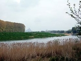
, forming an estuary
at Mont Saint-Michel
. Its final stretch forms the border between the historical duchies
of Normandy
and Brittany
. Its historically irregular course, alternating between two beds on the north and south of the Mont Saint-Michel
but eventually definitely settling to the south bed, inspired the saying "The Couesnon's madness placed Mont Saint-Michel in Normandy" ("le couesnon en sa folie mit le Mont en Normandie"), as the Mont is just to the Norman side of the river's current mouth. However, the administrative boundary separating the two regions does not depend on the course of the river, and is about six kilometers west of the Mont.

 The Couesnon, the Sée
and the Sélune
form part of the complex water system of the bay of Mont Saint-Michel. On one side, the tide
brings large quantities of sediment which cause large sandbars within the river. On the other, the three watercourses drive the sediment back out to sea.
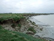
In the 20th century, the Couesnon was turned into a canal
, to reduce the erosion of its banks. In 1969, a dam
was built. These modifications, and the causeway
linking Mont Saint-Michel to the mainland, have caused the buildup of mudflats. To prevent the Mont becoming too connected to the mainland, plans are in place to replace the causeway with a bridge, and to modify the dam so that the sediment can once again be driven out to sea.
During spring tides, a tidal bore
— a wave caused by the incoming tide — can be seen working its way up the river.
The Couesnon flows through the following departments and towns:

has been measured at 8.26 (Hogan, 2006) and summer water temperature as 19 degrees Celsius in the area of the mouth. Water turbidity
is moderate with a Secchi disc reading of 14 centimetres. Electrical conductivity at the mouth is high even at the verge of the tidal influence.
River
A river is a natural watercourse, usually freshwater, flowing towards an ocean, a lake, a sea, or another river. In a few cases, a river simply flows into the ground or dries up completely before reaching another body of water. Small rivers may also be called by several other names, including...
running from the département of Mayenne
Mayenne
Mayenne is a department in northwest France named after the Mayenne River.-History:Mayenne is one of the original 83 departments created during the French Revolution on March 4, 1790. The northern two thirds correspond to the western part of the former province of Maine...
in north-western France
France
The French Republic , The French Republic , The French Republic , (commonly known as France , is a unitary semi-presidential republic in Western Europe with several overseas territories and islands located on other continents and in the Indian, Pacific, and Atlantic oceans. Metropolitan France...
, forming an estuary
Estuary
An estuary is a partly enclosed coastal body of water with one or more rivers or streams flowing into it, and with a free connection to the open sea....
at Mont Saint-Michel
Mont Saint-Michel
Mont Saint-Michel is a rocky tidal island and a commune in Normandy, France. It is located approximately one kilometre off the country's north-western coast, at the mouth of the Couesnon River near Avranches...
. Its final stretch forms the border between the historical duchies
Duchy
A duchy is a territory, fief, or domain ruled by a duke or duchess.Some duchies were sovereign in areas that would become unified realms only during the Modern era . In contrast, others were subordinate districts of those kingdoms that unified either partially or completely during the Medieval era...
of Normandy
Normandy
Normandy is a geographical region corresponding to the former Duchy of Normandy. It is in France.The continental territory covers 30,627 km² and forms the preponderant part of Normandy and roughly 5% of the territory of France. It is divided for administrative purposes into two régions:...
and Brittany
Brittany
Brittany is a cultural and administrative region in the north-west of France. Previously a kingdom and then a duchy, Brittany was united to the Kingdom of France in 1532 as a province. Brittany has also been referred to as Less, Lesser or Little Britain...
. Its historically irregular course, alternating between two beds on the north and south of the Mont Saint-Michel
Mont Saint-Michel
Mont Saint-Michel is a rocky tidal island and a commune in Normandy, France. It is located approximately one kilometre off the country's north-western coast, at the mouth of the Couesnon River near Avranches...
but eventually definitely settling to the south bed, inspired the saying "The Couesnon's madness placed Mont Saint-Michel in Normandy" ("le couesnon en sa folie mit le Mont en Normandie"), as the Mont is just to the Norman side of the river's current mouth. However, the administrative boundary separating the two regions does not depend on the course of the river, and is about six kilometers west of the Mont.
Geography
Sée
The Sée is an 78 km long river in the Manche department, Normandy, France, beginning near Sourdeval. It empties into the bay of Mont Saint-Michel in Avranches, close to the mouth of the Sélune river. Another town along the Sée is Brécey.-References:*http://www.geoportail.fr*...
and the Sélune
Sélune
The Sélune is a 91 km long river in the Manche department, Normandy, France, beginning near Saint-Cyr-du-Bailleul. It empties into the bay of Mont Saint-Michel near Avranches, close to the mouth of the Sée river. Other towns along the Sélune are Barenton, Saint-Hilaire-du-Harcouët and...
form part of the complex water system of the bay of Mont Saint-Michel. On one side, the tide
Tide
Tides are the rise and fall of sea levels caused by the combined effects of the gravitational forces exerted by the moon and the sun and the rotation of the Earth....
brings large quantities of sediment which cause large sandbars within the river. On the other, the three watercourses drive the sediment back out to sea.
In the 20th century, the Couesnon was turned into a canal
Canal
Canals are man-made channels for water. There are two types of canal:#Waterways: navigable transportation canals used for carrying ships and boats shipping goods and conveying people, further subdivided into two kinds:...
, to reduce the erosion of its banks. In 1969, a dam
Dam
A dam is a barrier that impounds water or underground streams. Dams generally serve the primary purpose of retaining water, while other structures such as floodgates or levees are used to manage or prevent water flow into specific land regions. Hydropower and pumped-storage hydroelectricity are...
was built. These modifications, and the causeway
Causeway
In modern usage, a causeway is a road or railway elevated, usually across a broad body of water or wetland.- Etymology :When first used, the word appeared in a form such as “causey way” making clear its derivation from the earlier form “causey”. This word seems to have come from the same source by...
linking Mont Saint-Michel to the mainland, have caused the buildup of mudflats. To prevent the Mont becoming too connected to the mainland, plans are in place to replace the causeway with a bridge, and to modify the dam so that the sediment can once again be driven out to sea.
During spring tides, a tidal bore
Tidal bore
A tidal bore is a tidal phenomenon in which the leading edge of the incoming tide forms a wave of water that travel up a river or narrow bay against the direction of the river or bay's current...
— a wave caused by the incoming tide — can be seen working its way up the river.
The Couesnon flows through the following departments and towns:
- Ille-et-VilaineIlle-et-VilaineIlle-et-Vilaine is a department of France, located in the region of Brittany in the northwest of the country.- History :Ille-et-Vilaine is one of the original 83 departments created during the French Revolution on March 4, 1790...
: FougèresFougèresFougères is a commune and a sub-prefecture of the Ille-et-Vilaine department in Brittany, in north-western France.-Sights:Fougères' major monument is a medieval stronghold built atop a granite ledge, which was part of the ultimately unsuccessful defence system of the Duchy of Brittany against...
, AntrainAntrainAntrain is a commune in the Ille-et-Vilaine department of Brittany in north-western France.-Demographics:Inhabitants of Antrain are called in French Antrenais.... - MancheMancheManche is a French department in Normandy named after La Manche , which is the French name for the English Channel.- History :Manche is one of the original 83 departments created during the French Revolution on March 4, 1790...
: PontorsonPontorsonPontorson is a commune in the Manche department in north-western France.-Geography:Pontorson is situated about 10 kilometres from the Mount, to which it is connected by highway and a walking path along the river Couesnon. The river also gives its name to the town's main street.-History:The town was...
Hydrology and water quality
Summer flow is typically in the range of 150 cuft/s. the pHPH
In chemistry, pH is a measure of the acidity or basicity of an aqueous solution. Pure water is said to be neutral, with a pH close to 7.0 at . Solutions with a pH less than 7 are said to be acidic and solutions with a pH greater than 7 are basic or alkaline...
has been measured at 8.26 (Hogan, 2006) and summer water temperature as 19 degrees Celsius in the area of the mouth. Water turbidity
Turbidity
Turbidity is the cloudiness or haziness of a fluid caused by individual particles that are generally invisible to the naked eye, similar to smoke in air. The measurement of turbidity is a key test of water quality....
is moderate with a Secchi disc reading of 14 centimetres. Electrical conductivity at the mouth is high even at the verge of the tidal influence.