
Coronado National Forest
Encyclopedia
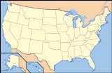
The Coronado National Forest
includes an area of about 1.78 million acres (7,200 km2) spread throughout mountain ranges in southeastern Arizona
and southwestern New Mexico
.
It is located in parts of Cochise
, Graham
, Santa Cruz
, Pima
, and Pinal
counties in Arizona, and Hidalgo County
in New Mexico.
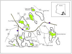
The National Forest is divided into five ranger districts. The districts themselves are not contiguous; each consists of multiple "sky island
" mountain ranges.
The Santa Catalina Ranger District
near the city of Tucson
comprises the Santa Catalina
and Rincon Mountains
. Included in this area is the highest peak of the Santa Catalinas, Mount Lemmon
, the rugged Pusch Ridge Wilderness Area
, and the popular Sabino Canyon
. Much of this district was part of Santa Catalina National Forest
before its inclusion in Coronado.
The Safford Ranger District comprises the mountain ranges surrounding the city of Safford, Arizona
. These five ranges are the Pinaleño
, Galiuro
, Santa Teresa
, Winchester, and Greasewood Mountains. Included in this area is the highest peak of the Pinaleños, Mount Graham
. Mount Graham National Forest
was a formerly separate national forest, combined into Crook National Forest
on July 1, 1908. In 1953 part of Crook was absorbed into Coronado.
The Nogales Ranger District comprises four mountain ranges north and west of Nogales, Arizona
. These ranges are the Santa Rita
, Tumacacori, Pajarito
, and San Luis Mountains
. Included in this area are Mount Hopkins
, Mount Wrightson
, and Madera Canyon
, all located in the Santa Ritas. In the early 20th century this area included two national forests which were absorbed into Coronado: Santa Rita National Forest
and Tumacacori National Forest
.
The Douglas Ranger District comprises three mountain ranges north and east of Douglas, Arizona
. These ranges are the Chiricahua
, Dragoon
, and Peloncillo Mountains
. A portion of the Ranger District in the Peloncillos extends into New Mexico. The district comprises three formerly separate national forests: Chiricahua National Forest
, Dragoon National Forest
and Peloncillo National Forest
, all combined into Coronado.
The Sierra Vista Ranger District comprises three mountain ranges west of Sierra Vista, Arizona
. These ranges are the Huachuca, Patagonia
, and Whetstone Mountains
. Included in this area is the highest peak in the Huachucas, Miller Peak, and the region of the Huachucas known as Canelo Hills. The district includes the formerly separate Huachuca National Forest
¡Three Amigos!
was partially filmed here in addition to Old Tucson Studios
.
 The Coronado National Forest contains eight designated wilderness areas, with at least one in each Ranger District. Congress defines Wilderness as an area "untrammeled by man." Common activities in the Coronado National Forest wilderness areas include hiking, horseback riding, camping, hunting, and fishing. The use of mechanized or motorized equipment, including bicycles, generators, and chain saws, is prohibited.
* Information is accurate as of Tuesday, 17 June 2008 at 13:39:50 EDT
on November 6, 1906 with 314125 acres (127,122 ha). It became a National Forest
on March 4, 1907. On July 1, 1908 the entire forest was combined with Baboquivari National Forest
and Tumacacori National Forest
to establish Garces National Forest
, and the name was discontinued. The lands are presently included in Coronado National Forest.
United States National Forest
National Forest is a classification of federal lands in the United States.National Forests are largely forest and woodland areas owned by the federal government and managed by the United States Forest Service, part of the United States Department of Agriculture. Land management of these areas...
includes an area of about 1.78 million acres (7,200 km2) spread throughout mountain ranges in southeastern Arizona
Arizona
Arizona ; is a state located in the southwestern region of the United States. It is also part of the western United States and the mountain west. The capital and largest city is Phoenix...
and southwestern New Mexico
New Mexico
New Mexico is a state located in the southwest and western regions of the United States. New Mexico is also usually considered one of the Mountain States. With a population density of 16 per square mile, New Mexico is the sixth-most sparsely inhabited U.S...
.
It is located in parts of Cochise
Cochise County, Arizona
-2010:Whereas according to the 2010 U.S. Census Bureau:*78.5% White*4.2% Black*1.2% Native American*1.9% Asian*0.3% Native Hawaiian or Pacific Islander*4.0% Two or more races*9.6% Other races*32.4% Hispanic or Latino -2000:...
, Graham
Graham County, Arizona
-2010:Whereas according to the 2010 U.S. Census Bureau:*72.1% White*1.8% Black*14.4% Native American*0.5% Asian*0.1% Native Hawaiian or Pacific Islander*2.8% Two or more races*8.3% Other races*30.4% Hispanic or Latino -2000:...
, Santa Cruz
Santa Cruz County, Arizona
-2010:Whereas according to the 2010 U.S. Census Bureau:*73.5% White*0.4% Black*0.7% Native American*0.5% Asian*0.0% Native Hawaiian or Pacific Islander*2.0% Two or more races*22.9% Other races*82.8% Hispanic or Latino -2000:...
, Pima
Pima County, Arizona
-2010:Whereas according to the 2010 U.S. Census Bureau:*74.3% White*3.5% Black*3.3% Native American*2.6% Asian*0.2% Native Hawaiian or Pacific Islander*3.7% Two or more races*12.4% Other races*34.6% Hispanic or Latino -2000:...
, and Pinal
Pinal County, Arizona
-2010:Whereas according to the 2010 U.S. Census Bureau:*72.4% White*4.6% Black*5.6% Native American*1.7% Asian*0.4% Native Hawaiian or Pacific Islander*3.8% Two or more races*11.5% Other races*28.5% Hispanic or Latino -2000:...
counties in Arizona, and Hidalgo County
Hidalgo County, New Mexico
-2010:Whereas according to the 2010 U.S. Census Bureau:*85.3% White*0.6% Black*0.8% Native American*0.5% Asian*0.0% Native Hawaiian or Pacific Islander*1.8% Two or more races*11.0% Other races*56.6% Hispanic or Latino...
in New Mexico.
The National Forest is divided into five ranger districts. The districts themselves are not contiguous; each consists of multiple "sky island
Sky island
Sky islands are mountains that are isolated by surrounding lowlands of a dramatically different environment, a situation which, in combination with the altitudinal zonation of ecosystems, has significant implications for natural habitats. Endemism, vertical migration, and relict populations are...
" mountain ranges.
The Santa Catalina Ranger District
Santa Catalina Ranger District
The Santa Catalina Ranger District governs the Santa Catalina Mountains within the Coronado National Forest, northeast of Tucson, Arizona.- See also :* Santa Catalina National Forest* Pusch Ridge Wilderness* Arizona Trail* Sabino Canyon* Pima Canyon...
near the city of Tucson
Tucson, Arizona
Tucson is a city in and the county seat of Pima County, Arizona, United States. The city is located 118 miles southeast of Phoenix and 60 miles north of the U.S.-Mexico border. The 2010 United States Census puts the city's population at 520,116 with a metropolitan area population at 1,020,200...
comprises the Santa Catalina
Santa Catalina Mountains
The Santa Catalina Mountains, commonly referred to as the Catalina Mountains, are located north, and northeast of Tucson, Arizona, United States, on Tucson's north perimeter. The mountain range is the most prominent in the Tucson area, with the highest average elevation...
and Rincon Mountains
Rincon Mountains
The Rincon Mountains are a significant mountain range east of Tucson, Pima County, Arizona, in the United States. The Rincon Mountains are one of five mountain ranges surrounding the Tucson valley...
. Included in this area is the highest peak of the Santa Catalinas, Mount Lemmon
Mount Lemmon
Mount Lemmon is in the Santa Catalina Mountains located in the Coronado National Forest north of Tucson, Arizona, United States. It is above sea-level, and receives approximately 180 inches of snow annually. Mount Lemmon was named in honor of botanist Sarah Lemmon, who trekked to the top of...
, the rugged Pusch Ridge Wilderness Area
Pusch Ridge Wilderness Area
Pusch Ridge Wilderness Area is a 56,430 acre wilderness area. It is located within the Coronado National Forest in the Santa Catalina Mountains north of Tucson, Arizona, United States...
, and the popular Sabino Canyon
Sabino Canyon
Sabino Canyon is a significant canyon located in the Santa Catalina Mountains and the Coronado National Forest north of Tucson, Arizona, USA. Sabino Canyon is a popular recreation area for residents and visitors of Southern Arizona, providing a place to walk, hike or ride. Minutes away from the...
. Much of this district was part of Santa Catalina National Forest
Santa Catalina National Forest
Santa Catalina National Forest was established as the Santa Catalina Forest Reserve by the General Land Office in Arizona on July 2, 1902 with . After the transfer of federal forests to the U.S. Forest Service in 1905, it became a National Forest on March 4, 1907...
before its inclusion in Coronado.
The Safford Ranger District comprises the mountain ranges surrounding the city of Safford, Arizona
Safford, Arizona
- History :Safford was founded by Joshua Eaton Bailey, Hiram Kennedy and Edward Tuttle, who came from Gila Bend, in southwestern Arizona. They left Gila Bend in the winter of 1873-74; their work on canals and dams having been destroyed by high water the previous summer...
. These five ranges are the Pinaleño
Pinaleno Mountains
The Pinaleño Mountains, or the Pinal Mountains, are a remote mountain range in southeastern Arizona. They have over of vertical relief, more than any other range in the state. The mountains are surrounded by the Sonoran-Chihuahuan Desert. Subalpine forests cover the higher elevations...
, Galiuro
Galiuro Mountains
The Galiuro Mountains are a large sky island mountain range of southeast Arizona, USA. It is a northerly mountain range in the Madrean Sky Islands region of southeast Arizona, northern Sonora, Northern Mexico, and extreme southwest, bootheel New Mexico....
, Santa Teresa
Santa Teresa Mountains
The Santa Teresa Mountains are located in western Graham County, Arizona, within the Coronado National Forest and within the Santa Teresa Wilderness.-External links:*...
, Winchester, and Greasewood Mountains. Included in this area is the highest peak of the Pinaleños, Mount Graham
Mount Graham
Mount Graham is a mountain in southeastern Arizona in the United States, in the Coronado National Forest. It is the highest mountain in the Pinaleño Mountains. As the name "Mount Graham" is often used by locals to refer to the entire mountain range, the peak itself is frequently referred to as...
. Mount Graham National Forest
Mount Graham National Forest
Mount Graham National Forest was established as the Mount Graham Forest Reserve in Arizona by the General Land Office on July 22, 1902 with . After the transfer of federal forests to the U.S. Forest Service in 1905, it became a National Forest on March 4, 1907...
was a formerly separate national forest, combined into Crook National Forest
Crook National Forest
Crook National Forest was established in Arizona by the U.S. Forest Service on July 1, 1908 with from portions of Tonto National Forest, Mount Graham National Forest and other lands. On July 1, 1953 Crook was divided among Tonto, Gila and Coronado National Forests. -External links:** Text from...
on July 1, 1908. In 1953 part of Crook was absorbed into Coronado.
The Nogales Ranger District comprises four mountain ranges north and west of Nogales, Arizona
Nogales, Arizona
Nogales is a city in Santa Cruz County, Arizona, United States. The population was 21,017 at the 2010 census. According to 2005 Census Bureau estimates, the population of the city is 20,833. The city is the county seat of Santa Cruz County....
. These ranges are the Santa Rita
Santa Rita Mountains
The Santa Rita Mountains, located about 65 km southeast of Tucson, Arizona, extend 42 km from north to south, then trending southeast. They merge again southeastwards into the Patagonia Mountains, trending northwest by southeast...
, Tumacacori, Pajarito
Pajarito Mountains
The Pajarito Mountains are a small mountain range of western Santa Cruz County, Arizona. The range is adjacent the Atascosa Mountains at its north, with both ranges in the center of a north-south sequence of ranges called the Tumacacori Highlands...
, and San Luis Mountains
San Luis Mountains
The San Luis Mountains are a small, lower elevation mountain range of central-southern Pima County Arizona adjacent the U.S.-Mexico border, northeast of Sasabe, Arizona–Sasabe, Sonora....
. Included in this area are Mount Hopkins
Mount Hopkins (Arizona)
Mount Hopkins is a mountain in Santa Cruz County, Arizona part of the Santa Rita Mountains range. Fred Lawrence Whipple Observatory is located on it. It is within the Coronado National Forest and was named after Gilbert Hopkins who was killed nearby in 1865 during the Battle of Fort Buchanan....
, Mount Wrightson
Mount Wrightson
Mount Wrightson is the highest point in the area around Tucson, Arizona, United States at an elevation of 9,453 feet . Mount Wrightson is located in the Santa Rita Mountains southeast of Tucson in the Coronado National Forest. It was named for William Wrightson, who was a miner and entrepreneur...
, and Madera Canyon
Madera Canyon
Madera Canyon is a canyon on the northwestern face of the Santa Rita Mountains, located 25 miles southeast of Tucson, Arizona. As part of the Coronado National Forest, the canyon has campsites, picnic areas, and miles of hiking trails. The canyon is used as a resting place for migrating birds, and...
, all located in the Santa Ritas. In the early 20th century this area included two national forests which were absorbed into Coronado: Santa Rita National Forest
Santa Rita National Forest
Santa Rita National Forest was established as the Santa Rita Forest Reserve by the General Land Office in Arizona on April 11, 1902 with . After the transfer of federal forests to the U.S. Forest Service in 1905, it became a National Forest on March 4, 1907...
and Tumacacori National Forest
Tumacacori National Forest
Tumacacori National Forest was established as the Tumacacori Forest Reserve by the U.S. Forest Service in Arizona on November 7, 1906 with . It became a National Forest on March 4, 1907. On July 1, 1908 the entire forest was combined with Baboquivari National Forest and Huachuca National Forest to...
.
The Douglas Ranger District comprises three mountain ranges north and east of Douglas, Arizona
Douglas, Arizona
Douglas is a city in Cochise County, Arizona, United States. Douglas has a border crossing with Mexico and a history of mining.The population was 14,312 at the 2000 census...
. These ranges are the Chiricahua
Chiricahua Mountains
The Chiricahua Mountains are a mountain range in southeastern Arizona which are part of the Basin and Range province of the southwest, and part of the Coronado National Forest...
, Dragoon
Dragoon Mountains
Dragoon Mountains are a range of mountains located in Cochise County, Arizona. The range is about 25 mi long, running on an axis extending south-south east through Willcox.- Geography :...
, and Peloncillo Mountains
Peloncillo Mountains (Cochise County)
The Peloncillo Mountains of Cochise County, , is a mountain range in northeast Cochise County, Arizona. A northern north-south stretch of the range extends to the southern region of Greenlee County on the northeast, and a southeast region of Graham County on the northwest...
. A portion of the Ranger District in the Peloncillos extends into New Mexico. The district comprises three formerly separate national forests: Chiricahua National Forest
Chiricahua National Forest
Chiricahua National Forest was established as the Chiricahua Forest Reserve in Cochise County, Arizona by the General Land Office on July 1, 1902 with . After the transfer of federal forests to the U.S. Forest Service in 1905, it became a National Forest on March 4, 1907. On July 1, 1908 it...
, Dragoon National Forest
Dragoon National Forest
Dragoon National Forest was established in Arizona on May 25, 1907, with . On July 1, 1908, it was combined with Santa Catalina National Forest and Santa Rita National Forest to create Coronado National Forest. The name was discontinued....
and Peloncillo National Forest
Peloncillo National Forest
Peloncillo National Forest was established as the Peloncillo Forest Reserve in Arizona and New Mexico on November 15, 1906 with . It became a National Forest on March 4, 1907. On July 1, 1908 it was combined with the Chiricahua National Forest and the name was discontinued...
, all combined into Coronado.
The Sierra Vista Ranger District comprises three mountain ranges west of Sierra Vista, Arizona
Sierra Vista, Arizona
Sierra Vista is a city in Cochise County, Arizona, United States. According to 2007 Census Bureau estimates, the population of the city is 43,044....
. These ranges are the Huachuca, Patagonia
Patagonia Mountains
The Patagonia Mountains is a 15 mile long mountain range south of the Santa Rita Mountains. Sonoita Creek flows in the valley north of the Patagonias. Both ranges are east of the Santa Cruz River Valley...
, and Whetstone Mountains
Whetstone Mountains
The Whetstone Mountains are a mountain range in southeastern Arizona. Major ranges in the region are part of sky island ranges called the Madrean Sky Islands. Part of the Coronado National Forest, the range is one of the least accessible areas...
. Included in this area is the highest peak in the Huachucas, Miller Peak, and the region of the Huachucas known as Canelo Hills. The district includes the formerly separate Huachuca National Forest
¡Three Amigos!
¡Three Amigos!
Three Amigos is a 1986 American adventure musical comedy film directed by John Landis and written by Lorne Michaels, Steve Martin, and Randy Newman...
was partially filmed here in addition to Old Tucson Studios
Old Tucson Studios
Old Tucson Studios is a movie studio and theme park just west of Tucson, Arizona, adjacent to the Tucson Mountains and close to the western portion of Saguaro National Park. Built in 1939 for the movie Arizona, it has been used for the filming of several movies and television westerns since then,...
.
Wilderness
- Chiricahua Wilderness (Douglas District)
- Galiuro WildernessGaliuro WildernessGaliuro Wilderness is a wilderness area encompassing the mid to upper slopes of the Galiuro Mountains. It is located within the Safford Ranger District of the Coronado National Forest in the U.S. state of Arizona. It is bordered on the south by the Redfield Canyon...
(Safford District) - Miller Peak Wilderness (Sierra Vista District)
- Mount Wrightson Wilderness (Nogales District)
- Pajarita Wilderness (Nogales District)
- Pusch Ridge Wilderness (Santa Catalina District)
- Rincon Wilderness (Santa Catalina District)
- Santa Teresa Wilderness (Safford District)
Campgrounds
Below is a table displaying all public campgrounds located within the Coronado National Forest. Most requiring a daily/nightly fee (see Coronado National Forest official website for accurate and current details), though some do not.| Campground | Status * | Elevation | Fee | Mountain Range |
|---|---|---|---|---|
| Arcadia | Open | 6700 | Yes | Pinaleño Mountains Pinaleno Mountains The Pinaleño Mountains, or the Pinal Mountains, are a remote mountain range in southeastern Arizona. They have over of vertical relief, more than any other range in the state. The mountains are surrounded by the Sonoran-Chihuahuan Desert. Subalpine forests cover the higher elevations... |
| Bathtub | Open | 6300 | Yes | Chiricahua Mountains Chiricahua Mountains The Chiricahua Mountains are a mountain range in southeastern Arizona which are part of the Basin and Range province of the southwest, and part of the Coronado National Forest... |
| Bog Springs | Open | 5200 | Yes | Santa Rita Mountains Santa Rita Mountains The Santa Rita Mountains, located about 65 km southeast of Tucson, Arizona, extend 42 km from north to south, then trending southeast. They merge again southeastwards into the Patagonia Mountains, trending northwest by southeast... |
| Cochise Stronghold | Developed sites Closed until Sept 1st. Dispersed camping is OPEN |
5000 | Yes | Dragoon Mountains Dragoon Mountains Dragoon Mountains are a range of mountains located in Cochise County, Arizona. The range is about 25 mi long, running on an axis extending south-south east through Willcox.- Geography :... |
| Cunningham | Open | 9000 | Yes | Pinaleño Mountains Pinaleno Mountains The Pinaleño Mountains, or the Pinal Mountains, are a remote mountain range in southeastern Arizona. They have over of vertical relief, more than any other range in the state. The mountains are surrounded by the Sonoran-Chihuahuan Desert. Subalpine forests cover the higher elevations... |
| Cypress Park | Open | 6000 | Yes | Chiricahua Mountains Chiricahua Mountains The Chiricahua Mountains are a mountain range in southeastern Arizona which are part of the Basin and Range province of the southwest, and part of the Coronado National Forest... |
| General Hitchcock | Open | 6000 | Yes | Santa Catalina Mountains Santa Catalina Mountains The Santa Catalina Mountains, commonly referred to as the Catalina Mountains, are located north, and northeast of Tucson, Arizona, United States, on Tucson's north perimeter. The mountain range is the most prominent in the Tucson area, with the highest average elevation... |
| Gordon Hirabayashi | Open | 5000 | Yes | Santa Catalina Mountains Santa Catalina Mountains The Santa Catalina Mountains, commonly referred to as the Catalina Mountains, are located north, and northeast of Tucson, Arizona, United States, on Tucson's north perimeter. The mountain range is the most prominent in the Tucson area, with the highest average elevation... |
| Herb Martyr | Open | 5800 | Yes | Chiricahua Mountains Chiricahua Mountains The Chiricahua Mountains are a mountain range in southeastern Arizona which are part of the Basin and Range province of the southwest, and part of the Coronado National Forest... |
| Hospital Flat | Open | 9000 | Yes | Pinaleño Mountains Pinaleno Mountains The Pinaleño Mountains, or the Pinal Mountains, are a remote mountain range in southeastern Arizona. They have over of vertical relief, more than any other range in the state. The mountains are surrounded by the Sonoran-Chihuahuan Desert. Subalpine forests cover the higher elevations... |
| Idlewilde | Open | 5000 | Yes | Chiricahua Mountains Chiricahua Mountains The Chiricahua Mountains are a mountain range in southeastern Arizona which are part of the Basin and Range province of the southwest, and part of the Coronado National Forest... |
| John Hands | Open | 5600 | No | Chiricahua Mountains Chiricahua Mountains The Chiricahua Mountains are a mountain range in southeastern Arizona which are part of the Basin and Range province of the southwest, and part of the Coronado National Forest... |
| Lakeview (Parker Cyn Lake) |
Open | 5400 | Yes | Huachuca Mountains (Canelo Hills) |
| Molino Basin | Open | 4500 | Yes | Santa Catalina Mountains Santa Catalina Mountains The Santa Catalina Mountains, commonly referred to as the Catalina Mountains, are located north, and northeast of Tucson, Arizona, United States, on Tucson's north perimeter. The mountain range is the most prominent in the Tucson area, with the highest average elevation... |
| Peppersauce | Open | 4700 | Yes | Santa Catalina Mountains Santa Catalina Mountains The Santa Catalina Mountains, commonly referred to as the Catalina Mountains, are located north, and northeast of Tucson, Arizona, United States, on Tucson's north perimeter. The mountain range is the most prominent in the Tucson area, with the highest average elevation... |
| Pinery Canyon | Open | 7000 | No | Chiricahua Mountains Chiricahua Mountains The Chiricahua Mountains are a mountain range in southeastern Arizona which are part of the Basin and Range province of the southwest, and part of the Coronado National Forest... |
| Ramsey Vista | Open | 7400 | Yes | Huachuca Mountains |
| Reef Townsite | Open | 7200 | Yes | Huachuca Mountains |
| Riggs Flat | Open | 8600 | Yes | Pinaleño Mountains Pinaleno Mountains The Pinaleño Mountains, or the Pinal Mountains, are a remote mountain range in southeastern Arizona. They have over of vertical relief, more than any other range in the state. The mountains are surrounded by the Sonoran-Chihuahuan Desert. Subalpine forests cover the higher elevations... |
| Rose Canyon | Open | 7000 | Yes | Santa Catalina Mountains Santa Catalina Mountains The Santa Catalina Mountains, commonly referred to as the Catalina Mountains, are located north, and northeast of Tucson, Arizona, United States, on Tucson's north perimeter. The mountain range is the most prominent in the Tucson area, with the highest average elevation... |
| Rucker Forest Camp | Open | 6500 | Yes | Chiricahua Mountains Chiricahua Mountains The Chiricahua Mountains are a mountain range in southeastern Arizona which are part of the Basin and Range province of the southwest, and part of the Coronado National Forest... |
| Rucker Lake | Open | 6300 | Yes | Chiricahua Mountains Chiricahua Mountains The Chiricahua Mountains are a mountain range in southeastern Arizona which are part of the Basin and Range province of the southwest, and part of the Coronado National Forest... |
| Rustler Park | Open | 8500 | Yes | Chiricahua Mountains Chiricahua Mountains The Chiricahua Mountains are a mountain range in southeastern Arizona which are part of the Basin and Range province of the southwest, and part of the Coronado National Forest... |
| Shannon | Open | 9100 | Yes | Pinaleño Mountains Pinaleno Mountains The Pinaleño Mountains, or the Pinal Mountains, are a remote mountain range in southeastern Arizona. They have over of vertical relief, more than any other range in the state. The mountains are surrounded by the Sonoran-Chihuahuan Desert. Subalpine forests cover the higher elevations... |
| Soldier Creek | Closed | 9300 | Yes | Pinaleño Mountains Pinaleno Mountains The Pinaleño Mountains, or the Pinal Mountains, are a remote mountain range in southeastern Arizona. They have over of vertical relief, more than any other range in the state. The mountains are surrounded by the Sonoran-Chihuahuan Desert. Subalpine forests cover the higher elevations... |
| Spencer Canyon | Open | 8000 | Yes | Santa Catalina Mountains Santa Catalina Mountains The Santa Catalina Mountains, commonly referred to as the Catalina Mountains, are located north, and northeast of Tucson, Arizona, United States, on Tucson's north perimeter. The mountain range is the most prominent in the Tucson area, with the highest average elevation... |
| Stewart | Open | 5100 | Yes | Chiricahua Mountains Chiricahua Mountains The Chiricahua Mountains are a mountain range in southeastern Arizona which are part of the Basin and Range province of the southwest, and part of the Coronado National Forest... |
| Stockton Pass | Open | 5600 | No | Pinaleño Mountains Pinaleno Mountains The Pinaleño Mountains, or the Pinal Mountains, are a remote mountain range in southeastern Arizona. They have over of vertical relief, more than any other range in the state. The mountains are surrounded by the Sonoran-Chihuahuan Desert. Subalpine forests cover the higher elevations... |
| Sunny Flat | Open | 5200 | Yes | Chiricahua Mountains Chiricahua Mountains The Chiricahua Mountains are a mountain range in southeastern Arizona which are part of the Basin and Range province of the southwest, and part of the Coronado National Forest... |
| Sycamore | Open | 6200 | Yes | Chiricahua Mountains Chiricahua Mountains The Chiricahua Mountains are a mountain range in southeastern Arizona which are part of the Basin and Range province of the southwest, and part of the Coronado National Forest... |
| W Turkey Creek | Open | 5900 | Yes | Chiricahua Mountains Chiricahua Mountains The Chiricahua Mountains are a mountain range in southeastern Arizona which are part of the Basin and Range province of the southwest, and part of the Coronado National Forest... |
| White Rock | Open | 4000 | Yes | Tumacacori Mountains |
* Information is accurate as of Tuesday, 17 June 2008 at 13:39:50 EDT
Huachuca National Forest
Huachuca National Forest was established as the Huachuca Forest Reserve by the U.S. Forest Service in ArizonaArizona
Arizona ; is a state located in the southwestern region of the United States. It is also part of the western United States and the mountain west. The capital and largest city is Phoenix...
on November 6, 1906 with 314125 acres (127,122 ha). It became a National Forest
United States National Forest
National Forest is a classification of federal lands in the United States.National Forests are largely forest and woodland areas owned by the federal government and managed by the United States Forest Service, part of the United States Department of Agriculture. Land management of these areas...
on March 4, 1907. On July 1, 1908 the entire forest was combined with Baboquivari National Forest
Baboquivari National Forest
Baboquivari National Forest was established as the Baboquivari Forest Reserve by the U.S. Forest Service in Arizona on November 5, 1906 with . On March 4, 1907 it became a National Forest, and on July 1, 1908 the entire forest was combined with Huachuca National Forest and Tumacacori National...
and Tumacacori National Forest
Tumacacori National Forest
Tumacacori National Forest was established as the Tumacacori Forest Reserve by the U.S. Forest Service in Arizona on November 7, 1906 with . It became a National Forest on March 4, 1907. On July 1, 1908 the entire forest was combined with Baboquivari National Forest and Huachuca National Forest to...
to establish Garces National Forest
Garces National Forest
Garces National Forest was established by the U.S. Forest Service in Arizona on July 1, 1908 with from portions of Baboquivari, Tumacacori and Huachuca National Forests. It was named in honor of Franciscan missionary Father Francisco Garcés - an early exlorer of southwestern North America...
, and the name was discontinued. The lands are presently included in Coronado National Forest.
External links
- Coronado National Forest Web Site
- Forest History Society
- Hikes in the Coronado National Forest at HikeArizona.COM
- Listing of the National Forests of the United States and Their Dates (from Forest History SocietyForest History SocietyThe Forest History Society is an American non-profit organization dedicated to the preservation of forest and conservation history. The society was established in 1946 and incorporated in 1955....
website) Text from Davis, Richard C., ed. Encyclopedia of American Forest and Conservation History. New York: Macmillan Publishing Company for the Forest History Society, 1983. Vol. II, pp. 743-788.