

Cordillera Central, Bolivia
Encyclopedia
Bolivia
Bolivia officially known as Plurinational State of Bolivia , is a landlocked country in central South America. It is the poorest country in South America...
n mountain range
Mountain range
A mountain range is a single, large mass consisting of a succession of mountains or narrowly spaced mountain ridges, with or without peaks, closely related in position, direction, formation, and age; a component part of a mountain system or of a mountain chain...
that divides the three river basins in the country and also has the second highest peaks in Bolivia. It is rich in minerals and starts in the north with Chaupi Orco
Chaupi Orco
Chaupi Orco is a mountain in the Andes of Bolivia, on the border with Peru. It has a height of ....
and the three Palomanis that were in the south up to Zapaleri
Zapaleri
Cerro Zapaleri is an extint volcano whose summit is the tripoint of the borders of Argentina, Bolivia and Chile. It is part of Potosí Department , Jujuy Province , and Antofagasta Region ....
, forming a border with Chile
Chile
Chile ,officially the Republic of Chile , is a country in South America occupying a long, narrow coastal strip between the Andes mountains to the east and the Pacific Ocean to the west. It borders Peru to the north, Bolivia to the northeast, Argentina to the east, and the Drake Passage in the far...
and Argentina
Argentina
Argentina , officially the Argentine Republic , is the second largest country in South America by land area, after Brazil. It is constituted as a federation of 23 provinces and an autonomous city, Buenos Aires...
. The Cordillera Central is divided into three sections:
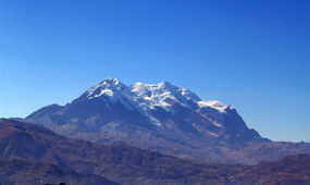
- The northern section or Cordillera RealCordillera Real (Bolivia)The Cordillera Real is a mountain range in the South American Altiplano of Bolivia. This range of fold mountains, largely composed of granite, is located southeast of Lake Titicaca, and east of the Bolivian capital of La Paz, measuring 125 km in length and 20 km in width...
, with Chaupi Orco and the three Palomanis, also taking into account the most significant of Bolivia that you find near La PazLa PazNuestra Señora de La Paz is the administrative capital of Bolivia, as well as the departmental capital of the La Paz Department, and the second largest city in the country after Santa Cruz de la Sierra...
, IllimaniIllimaniIllimani is the highest mountain in the Cordillera Real of western Bolivia. It lies just south of La Paz at the eastern edge of the Altiplano. It is the second highest peak in Bolivia, after Nevado Sajama, and the eighteenth highest peak in South America...
, IllampuIllampuIllampú is the fourth highest mountain in Bolivia. It is located in the northern section of the Cordillera Real, part of the Andes, east of Lake Titicaca. It lies just north of the slightly higher Ancohuma, near the town of Sorata...
, AncohumaAncohumaAncohuma is the third highest mountain in Bolivia . It is located in the northern section of the Cordillera Real, part of the Andes, east of Lake Titicaca...
, MururataMururataMururata is a mountain in the Cordillera Real of Bolivia. Approximately 35km East of La Paz, the Mururata lies to the North of the Illimani. The Mururata offers accessible climbing, as its shape does not contain difficult obstacles ....
, and Huayna PotosíHuayna PotosíHuayna Potosí is a mountain in Bolivia, located about 25 km north of La Paz in the Cordillera Real.Huayna Potosí is the closest high mountain to La Paz, a city which is surrounded by high mountains, and itself is the highest capital city in the world. Huayna Potosí is roughly fifteen miles due...
, all of which are more than 6,000 meters high. This section is very famous because the highest meteorological observatory in the world can be found on ChacaltayaChacaltayaChacaltaya is a mountain in the Cordillera Real, one of the mountain ranges of the Cordillera Oriental, itself a range of the Bolivian Andes. Its elevation is . Chacaltaya's glacier - which was as old as 18,000 years – had in 1940 an area of , reduced to in 2007 and was completely gone by 2009....
. Some of the highest skiSkiA ski is a long, flat device worn on the foot, usually attached through a boot, designed to help the wearer slide smoothly over snow. Originally intended as an aid to travel in snowy regions, they are now mainly used for recreational and sporting purposes...
slopes in the world can be found here also.
- The central section contains Sumac Orcko, with the Andacava mountains and the Paso de Condor rail station, both situated at an elevation of 4,288 meters.
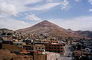
- The southern section is characterized by its high rate of mineralization and large deposits of tin. Its highest summit is Zapalieri on the border with Chile and Argentina.
See also
- Cordillera Occidental (Bolivia)
- Cordillera Oriental (Bolivia)
- Cordillera CentralCordillera CentralThe Cordillera Central, meaning central range in Spanish, is used to refer to several mountain ranges around the world:* Cordillera Central, Andes , several mountain ranges in South America** Cordillera Central, Colombia...