

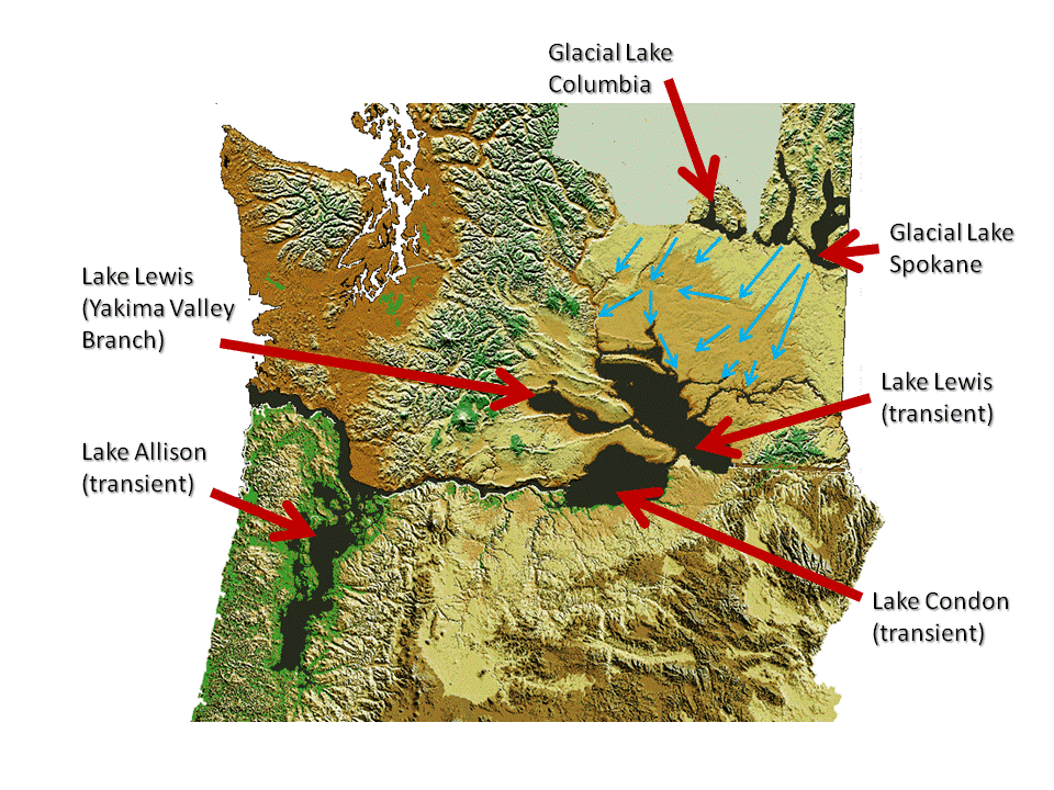
Glacial Lake Columbia
Encyclopedia
Columbia River
The Columbia River is the largest river in the Pacific Northwest region of North America. The river rises in the Rocky Mountains of British Columbia, Canada, flows northwest and then south into the U.S. state of Washington, then turns west to form most of the border between Washington and the state...
behind the Okanogan lobe of the Cordilleran Ice Sheet
Cordilleran Ice Sheet
The Cordilleran ice sheet was a major ice sheet that covered, during glacial periods of the Quaternary, a large area of North America. This included the following areas:*Western Montana*The Idaho Panhandle...
when the lobe covered 500 square miles (1,295 km²) of the Waterville Plateau west of Grand Coulee
Grand Coulee
The Grand Coulee is an ancient river bed in the U.S. state of Washington. This National Natural Landmark stretches for about sixty miles southwest from Grand Coulee Dam to Soap Lake, being bisected by Dry Falls into the Upper and Lower Grand Coulee....
in central Washington state during the Wisconsin glaciation
Wisconsin glaciation
The last glacial period was the most recent glacial period within the current ice age occurring during the last years of the Pleistocene, from approximately 110,000 to 10,000 years ago....
. Lake Columbia was a substantially larger version of the modern-day lake behind the Grand Coulee Dam
Grand Coulee Dam
Grand Coulee Dam is a gravity dam on the Columbia River in the U.S. state of Washington built to produce hydroelectric power and provide irrigation. It was constructed between 1933 and 1942, originally with two power plants. A third power station was completed in 1974 to increase its energy...
. Lake Columbia's overflow – the diverted Columbia River – drained first through Moses Coulee
Moses Coulee
Moses Coulee cuts into the Waterville plateau in Douglas County, Washington. It is to the west of and roughly parallel to the more famous Grand Coulee...
and as the ice dam grew, later through the Grand Coulee
Grand Coulee
The Grand Coulee is an ancient river bed in the U.S. state of Washington. This National Natural Landmark stretches for about sixty miles southwest from Grand Coulee Dam to Soap Lake, being bisected by Dry Falls into the Upper and Lower Grand Coulee....
.
Glacial Lake Missoula
The Cordilleran ice sheet also blocked the Clark Fork River and created Glacial Lake MissoulaGlacial Lake Missoula
Glacial Lake Missoula was a prehistoric proglacial lake in western Montana that existed periodically at the end of the last ice age between 15,000 and 13,000 years ago...
, rising behind a 2000 feet (609.6 m) high ice dam in flooded valleys of western Montana. Over 2000 years the ice dam periodically failed, releasing approximately 40 high-volume Missoula Floods
Missoula Floods
The Missoula Floods refer to the cataclysmic floods that swept periodically across eastern Washington and down the Columbia River Gorge at the end of the last ice age. The glacial flood events have been researched since the 1920s...
of water down the Columbia River drainage, passing through glacial Lake Columbia. The largest flood is estimated to be the initial flood at 2,500 km3 (600 mi3), with subsequent floods occurring at roughly 20 to 80 year intervals. Since Lake Columbia was impounded behind the Okanogan lobe, which rose to 1300 metres (4,265.1 ft), this lobe effectively blocked the normal course of the Columbia River, blocking the Missoula Floods and diverting water to flow across much of eastern Washington state. The erosion from the floods created the Grand Coulee as well as the Dry Falls
Dry Falls
Dry Falls is a 3.5 mile long scalloped precipice in central Washington, on the opposite side of the Upper Grand Coulee from the Columbia River, and at the head of the Lower Grand Coulee. Ten times the size of Niagara, Dry Falls is thought to be the greatest known waterfall that ever existed...
, Palouse Falls
Palouse Falls
The Palouse Falls lies on the Palouse River, about upstream of the confluence with the Snake River in southeast Washington, United States. The falls are in height...
, and the Channeled Scablands
Channeled scablands
The Channeled Scablands are a unique geological erosion feature in the U.S. state of Washington. They were created by the cataclysmic Missoula Floods that swept periodically across eastern Washington and down the Columbia River Plateau during the Pleistocene epoch. Geologist J Harlen Bretz coined...
features of eastern Washington state.
Flood deposits
Flood beds on the Sanpoil arm of glacial Lake Columbia show episodic flood deposits as well as deposit grading and rhythmical repetition. Since Glacial Lake Columbia remained filled between Missoula floods, annual deposits (varveVarve
A varve is an annual layer of sediment or sedimentary rock.The word 'varve' is derived from the Swedish word varv whose meanings and connotations include 'revolution', 'in layers', and 'circle'. The term first appeared as Hvarfig lera on the first map produced by the Geological Survey of Sweden in...
s) can be observed between the Missoula flood deposits, they help to establish the periodicity of these major floods. The flood deposits can be distinguished from annually-deposited varves by both their thickness and the presence of materials foreign to the immediate drainage. Atwater reports from 35 to 55 annual varves between flood deposits in Lake Columbia, supporting a period of 35 to 55 years between ice dam failures.