
Columbia-Shuswap Regional District, British Columbia
Encyclopedia
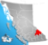
The Columbia-Shuswap Regional District is a regional district in the Canadian province of British Columbia
, located in the Southern Interior
region on the Trans-Canada Highway
between Vancouver
and Calgary
. The regional district comprises the regions known as the Shuswap Country
, which focuses around Shuswap Lake
and lies to the north of the Okanagan
, and the northern part of the Columbia Country
, namely the "Big Bend" of the valley of the Columbia River
from the Town of Golden
to the City of Revelstoke
(Revelstoke is sometimes referred to as being in the North Kootenay
, Golden is usually thought of as being part of the East Kootenay sub-region, the Columbia Valley
). The Canada 2006 Census
population was 50,141. The regional district's offices are in Salmon Arm
.
British Columbia
British Columbia is the westernmost of Canada's provinces and is known for its natural beauty, as reflected in its Latin motto, Splendor sine occasu . Its name was chosen by Queen Victoria in 1858...
, located in the Southern Interior
British Columbia Interior
The British Columbia Interior or BC Interior or Interior of British Columbia, usually referred to only as the Interior, is one of the three main regions of the Canadian province of British Columbia, the other two being the Lower Mainland, which comprises the overlapping areas of Greater Vancouver...
region on the Trans-Canada Highway
Trans-Canada Highway
The Trans-Canada Highway is a federal-provincial highway system that joins the ten provinces of Canada. It is, along with the Trans-Siberian Highway and Australia's Highway 1, one of the world's longest national highways, with the main route spanning 8,030 km...
between Vancouver
Vancouver
Vancouver is a coastal seaport city on the mainland of British Columbia, Canada. It is the hub of Greater Vancouver, which, with over 2.3 million residents, is the third most populous metropolitan area in the country,...
and Calgary
Calgary
Calgary is a city in the Province of Alberta, Canada. It is located in the south of the province, in an area of foothills and prairie, approximately east of the front ranges of the Canadian Rockies...
. The regional district comprises the regions known as the Shuswap Country
Shuswap Country
The Shuswap Country, or simply "the Shuswap" is a term used in the Canadian province of British Columbia to refer to the environs of Shuswap Lake. The upper reaches of the Shuswap basin, southeast of Shuswap Lake and northeast of the Okanagan, are generally considered to be part of Okanagan or of...
, which focuses around Shuswap Lake
Shuswap Lake
Shuswap Lake is a lake located in south-central British Columbia, Canada that drains via the Little River into Little Shuswap Lake. Little Shuswap Lake is the source of the South Thompson River, a branch of the Thompson River, a tributary of the Fraser River...
and lies to the north of the Okanagan
Okanagan
The Okanagan , also known as the Okanagan Valley and sometimes as Okanagan Country is a region located in the Canadian province of British Columbia defined by the basin of Okanagan Lake and the Canadian portion of the Okanagan River. As of 2009, the region's population is approximately 350,927. The...
, and the northern part of the Columbia Country
Columbia Country
The Columbia Country is a term used in the Canadian province of British Columbia to refer to the upper basin of the Columbia River in that province. It includes a smaller region known as the Columbia Valley, near the river's headwaters at Columbia Lake in the Rocky Mountain Trench, and the Big...
, namely the "Big Bend" of the valley of the Columbia River
Columbia River
The Columbia River is the largest river in the Pacific Northwest region of North America. The river rises in the Rocky Mountains of British Columbia, Canada, flows northwest and then south into the U.S. state of Washington, then turns west to form most of the border between Washington and the state...
from the Town of Golden
Golden, British Columbia
Golden is a town in southeastern British Columbia, Canada, located west of Calgary, Alberta and east of Vancouver.-History:Much of the town's history is tied into the Canadian Pacific Railway and the logging industry...
to the City of Revelstoke
Revelstoke, British Columbia
Revelstoke is a city in southeastern British Columbia, Canada. It is located east of Vancouver, and west of Calgary, Alberta. The city is situated on the banks of the Columbia River just south of the Revelstoke Dam and near its confluence with the Illecillewaet River...
(Revelstoke is sometimes referred to as being in the North Kootenay
Kootenays
The Kootenay Region comprises the southeastern portion of British Columbia. It takes its name from the Kootenay River, which in turn was named for the Ktunaxa First Nation first encountered by explorer David Thompson.-Boundaries:The Kootenays are more or less defined by the Kootenay Land...
, Golden is usually thought of as being part of the East Kootenay sub-region, the Columbia Valley
Columbia Valley
The Columbia Valley is the name used for a region in the Rocky Mountain Trench near the headwaters of the Columbia River between the town of Golden and the Canal Flats. The main hub of the valley is the town of Invermere. Other towns include Radium Hot Springs, Windermere and Fairmont Hot Springs...
). The Canada 2006 Census
Canada 2006 Census
The Canada 2006 Census was a detailed enumeration of the Canadian population. Census day was May 16, 2006. The next census following will be the 2011 Census. Canada's total population enumerated by the 2006 census was 31,612,897...
population was 50,141. The regional district's offices are in Salmon Arm
Salmon Arm, British Columbia
-Climate:- Education :Public schools in Salmon Arm are part of School District 83 North Okanagan-Shuswap; within the city limits, there are currently five elementary schools , one middle school , and a secondary school with two campuses...
.
Incorporated Communities
- Salmon Arm- 16,012
- RevelstokeRevelstoke, British ColumbiaRevelstoke is a city in southeastern British Columbia, Canada. It is located east of Vancouver, and west of Calgary, Alberta. The city is situated on the banks of the Columbia River just south of the Revelstoke Dam and near its confluence with the Illecillewaet River...
- 7,230 - GoldenGolden, British ColumbiaGolden is a town in southeastern British Columbia, Canada, located west of Calgary, Alberta and east of Vancouver.-History:Much of the town's history is tied into the Canadian Pacific Railway and the logging industry...
- 3,811 - SicamousSicamous, British ColumbiaSicamous, British Columbia is a town in British Columbia located adjacent to the Trans-Canada Highway at the Highway 97A junction of Mara Lake and the Shuswap Lake system. It is known as a popular all season tourist destination attracting visitors from throughout Canada and around the world...
- 2,676
Regional District Electoral Areas
- Columbia-Shuswap Electoral Area "A" - 3,097
- Columbia-Shuswap Electoral Area "B" - 706
- Columbia-Shuswap Electoral Area "C"Columbia-Shuswap C, British ColumbiaColumbia-Shuswap C is a regional district electoral area in the Columbia-Shuswap Regional District, British Columbia, Canada. The electoral area is located in south-central BC between the Main Arm and Salmon Arm of Shuswap Lake...
- 7,695 - Columbia-Shuswap Electoral Area "D"Columbia-Shuswap D, British ColumbiaThe Columbia-Shuswap Electoral Area D, referred to by Statistics Canada as Columbia-Shuswap D, is a regional district electoral area in the South-west corner of the Columbia-Shuswap Regional District of British Columbia. It contains the communities of Falkland, Ranchero, and Silver Creek...
- 3,899 - Columbia-Shuswap Electoral Area "E" - 1,528
- Columbia-Shuswap Electoral Area "F" - 2,731
Unincorporated Communities
- Anglemont- 454
- Blind BayBlind Bay, British ColumbiaBlind Bay is an unincorporated settlement located on the bay of the same name, at the southwest end of Shuswap Lake in the Shuswap Country region of the Southern Interior of British Columbia, Canada....
- 1,149 - CelistaCelista, British ColumbiaCelista is a small community located along the north shore of Shuswap Lake in British Columbia, Canada.The local school is North Shuswap Elementary school, which has grades one to seven and has an annual enrolement of just over 100 students....
- 408 - CraigellachieCraigellachie, British ColumbiaCraigellachie is a locality in British Columbia, located several kilometres to the west of the Eagle Pass summit between Sicamous and Revelstoke...
- Eagle BayEagle Bay, British ColumbiaEagle Bay is a small community located on the Shuswap Highland Peninsula on the southern shore of Shuswap Lake in British Columbia, Canada.-Location and Nearby Settlements:...
- 528 - FalklandFalkland, British ColumbiaFalkland is a small community located in the Okanagan-Shuswap region of British Columbia, Canada between Vernon and Kamloops.Falkland is recognized for one Canada's largest Canadian flags, which is located on Gyp Mountain and can be seen up to 7 km away. The Falkland area has a wide array of...
- 805 - MalawkaMalakwa, British ColumbiaMalakwa is a settlement in the Southern Interior of British Columbia, Canada, in the Eagle River valley, along the Trans-Canada Highway between Sicamous and Revelstoke. It had a population of 649 people in 2001....
- 619 - Notch Hill- 515
- Ranchero- 971
- Scotch CreekScotch Creek, British ColumbiaScotch Creek is a small community in British Columbia based on summer tourism located on the shores of northern Shuswap Lake at the mouth of the creek of the same name.-References:""...
- 762 - Silver Creek- 1,038
- SorrentoSorrento, British ColumbiaSorrento is an unincorporated settlement located on the south shore of Shuswap Lake in the Southern Interior of the Canadian province of British Columbia. It is located on the Trans-Canada Highway, and is 16 miles northeast of the town of Chase and 28 miles northwest of the city of Salmon Arm...
- 1,360 - Sunnybrae- 699
- Swansea Point- 243
- TappenTappen, British ColumbiaTappen is a settlement in British Columbia....
- 773 - White Lake- 623