
Shuswap Lake
Encyclopedia
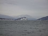
Shuswap Lake is a lake
located in south-central British Columbia
, Canada
that drains via the Little River
into Little Shuswap Lake
. Little Shuswap Lake is the source of the South Thompson River, a branch of the Thompson River
, a tributary of the Fraser River
. It is at the heart of a region known as the Shuswap Country
or "the Shuswap", noted for its recreational lakeshore communities including the city of Salmon Arm
. The name "Shuswap" is derived from the Shuswap
or Secwepemc
First Nations people, the most northern of the Interior Salish peoples, whose territory includes the Shuswap.
, forming a shape reminiscent of the letter H. The four arms are called Salmon Arm (southwest), Anstey Arm (northeast), Seymour Arm (north), and the main lake (west). Shuswap Lake connects to Little Shuswap Lake via the Little River, which flows from the end of the west arm.
To the north-west it is fed by the Adams River
, which drains Adams Lake
. Shuswap Lake connects to Mara Lake
at the Sicamous Channel. The Shuswap River
connects via Mara Lake
. In the south-west the Salmon River flows into the lake at Salmon Arm. The Eagle River
runs down from the Eagle Pass
in the Monashees to enter the lake at Sicamous, in the east. The Seymour River empties into the northern end of the Seymour Arm. In addition to these rivers, numerous creeks feed the lake, including Scotch Creek, which runs south to the north shore of the main arm, near the community of the same name.
Lake
A lake is a body of relatively still fresh or salt water of considerable size, localized in a basin, that is surrounded by land. Lakes are inland and not part of the ocean and therefore are distinct from lagoons, and are larger and deeper than ponds. Lakes can be contrasted with rivers or streams,...
located in south-central British Columbia
British Columbia
British Columbia is the westernmost of Canada's provinces and is known for its natural beauty, as reflected in its Latin motto, Splendor sine occasu . Its name was chosen by Queen Victoria in 1858...
, Canada
Canada
Canada is a North American country consisting of ten provinces and three territories. Located in the northern part of the continent, it extends from the Atlantic Ocean in the east to the Pacific Ocean in the west, and northward into the Arctic Ocean...
that drains via the Little River
Little River (Shuswap)
The Little River, also known as the Little Shuswap River, is a river in the Shuswap Country region of British Columbia, Canada. It drains Shuswap Lake just below the mouth of the Adams River and feeds Little Shuswap Lake, which is the head of the South Thompson River...
into Little Shuswap Lake
Little Shuswap Lake
Little Shuswap Lake is a small lake in the Thompson River basin of the southern Interior of British Columbia, Canada, which sits at the transition between the Thompson Country to the west and the Shuswap Country to the east...
. Little Shuswap Lake is the source of the South Thompson River, a branch of the Thompson River
Thompson River
The Thompson River is the largest tributary of the Fraser River, flowing through the south-central portion of British Columbia, Canada. The Thompson River has two main branches called the South Thompson and the North Thompson...
, a tributary of the Fraser River
Fraser River
The Fraser River is the longest river within British Columbia, Canada, rising at Fraser Pass near Mount Robson in the Rocky Mountains and flowing for , into the Strait of Georgia at the city of Vancouver. It is the tenth longest river in Canada...
. It is at the heart of a region known as the Shuswap Country
Shuswap Country
The Shuswap Country, or simply "the Shuswap" is a term used in the Canadian province of British Columbia to refer to the environs of Shuswap Lake. The upper reaches of the Shuswap basin, southeast of Shuswap Lake and northeast of the Okanagan, are generally considered to be part of Okanagan or of...
or "the Shuswap", noted for its recreational lakeshore communities including the city of Salmon Arm
Salmon Arm, British Columbia
-Climate:- Education :Public schools in Salmon Arm are part of School District 83 North Okanagan-Shuswap; within the city limits, there are currently five elementary schools , one middle school , and a secondary school with two campuses...
. The name "Shuswap" is derived from the Shuswap
Shuswap
Shuswap *Secwepemc - an indigenous people in British Columbia, Canada, also known in English as the Shuswap*Shuswap language - a language spoken by the Secwepemc...
or Secwepemc
Secwepemc
The Secwepemc , known in English as the Shuswap people, are a First Nations people residing in the Canadian province of British Columbia. Their traditional territory ranges from the eastern Chilcotin Plateau and the Cariboo Plateau southeast through the Thompson Country to Kamloops and the Shuswap...
First Nations people, the most northern of the Interior Salish peoples, whose territory includes the Shuswap.
Geography
Shuswap Lake consists of four armsArm (geography)
In geography, an arm is a narrow extension, inlet, or smaller reach, of water from a much larger body of water, like an ocean, sea, or lake. Although different geographically, a sound or bay may be called an arm....
, forming a shape reminiscent of the letter H. The four arms are called Salmon Arm (southwest), Anstey Arm (northeast), Seymour Arm (north), and the main lake (west). Shuswap Lake connects to Little Shuswap Lake via the Little River, which flows from the end of the west arm.
To the north-west it is fed by the Adams River
Adams River (British Columbia)
The Adams River is a tributary of the Fraser River in British Columbia, Canada. Beginning in the Monashee Mountains to the north, the Upper Adams River flows mainly southward and eventually reaches Adams Lake. The Lower Adams River begins at the southern end of the lake and flows into the extreme...
, which drains Adams Lake
Adams Lake
Adams Lake is a large, deep, coldwater lake. The southern end of the lake is approximately north of the town of Chase in the Shuswap Country region of British Columbia, Canada. The lake's upper reaches lie in the northern Monashee Mountains, while its lower end penetrates the Shuswap...
. Shuswap Lake connects to Mara Lake
Mara Lake
Mara Lake is a lake in the Shuswap Country of the Southern Interior of British Columbia, Canada, located immediately south of the community of Sicamous and to the north of the community of Enderby. It is the outlet of the Shuswap River, which begins in the Monashee Mountains to the east...
at the Sicamous Channel. The Shuswap River
Shuswap River
The basin of the Shuswap River lies northeast of the Okanagan Valley in British Columbia. It is the upper part of the drainage better known to British Columbians as belonging to Shuswap Lake and the South Thompson River...
connects via Mara Lake
Mara Lake
Mara Lake is a lake in the Shuswap Country of the Southern Interior of British Columbia, Canada, located immediately south of the community of Sicamous and to the north of the community of Enderby. It is the outlet of the Shuswap River, which begins in the Monashee Mountains to the east...
. In the south-west the Salmon River flows into the lake at Salmon Arm. The Eagle River
Eagle River (Shuswap)
The Eagle River is a river in the Canadian province of British Columbia.The river was named by Walter Moberly after following the flight of eagles and finding Eagle Pass.-Course:...
runs down from the Eagle Pass
Eagle Pass
Eagle Pass is a mountain pass through the Gold Range of the Monashee Mountains in British Columbia, Canada. It divides the Columbia River drainage basin from that of the Fraser River ....
in the Monashees to enter the lake at Sicamous, in the east. The Seymour River empties into the northern end of the Seymour Arm. In addition to these rivers, numerous creeks feed the lake, including Scotch Creek, which runs south to the north shore of the main arm, near the community of the same name.
Provincial parks around Shuswap Lake
Several parks are located on the shores of Shuswap Lake, including:- Shuswap Lake Provincial ParkShuswap Lake Provincial ParkShuswap Lake Provincial Park is a provincial park in British Columbia, Canada.Shuswap Lake Provincial Park is located in the community of Scotch Creek, on the north shore of the main arm of Shuswap Lake in the Southern Interior of BC. The park is about 45 minutes north of Salmon Arm, and about 1...
- Shuswap Lake Marine Provincial ParkShuswap Lake Marine Provincial ParkShuswap Lake Marine Provincial Park is a 896-hectare provincial park in British Columbia, Canada, comprising 991 ha. The Park has a variety of amenities including boat launch ramps, picnic areas, and 27 campsites around the perimeter of Shuswap Lake...
- Silver Beach Provincial ParkSilver Beach Provincial ParkSilver Beach Provincial Park is a provincial park in British Columbia, Canada, located at the head of the Seymour Arm of Shuswap Lake in that province's Shuswap Country, adjacent to the settlement of Seymour Arm....
- Roderick Haig-Brown Provincial ParkRoderick Haig-Brown Provincial ParkRoderick Haig-Brown Provincial Park is a provincial park in British Columbia, Canada, located northeast of Kamloops and northwest of Salmon Arm. It stretches along the banks of the Adams River, between the south end of Adams Lake and the western portion of Shuswap Lake...
(home of the Adams River Sockeye Run) - Cinnemousun Narrows Provincial ParkCinnemousun Narrows Provincial ParkCinnemousun Narrows Provincial Park is a provincial park in British Columbia, Canada, located on Shuswap Lake at the convergence of the lake's four arms.-References:*...
(located at the center of the H)
Communities
Communities bordering the Shuswap Lakes include:- Salmon ArmSalmon Arm, British Columbia-Climate:- Education :Public schools in Salmon Arm are part of School District 83 North Okanagan-Shuswap; within the city limits, there are currently five elementary schools , one middle school , and a secondary school with two campuses...
- CelistaCelista, British ColumbiaCelista is a small community located along the north shore of Shuswap Lake in British Columbia, Canada.The local school is North Shuswap Elementary school, which has grades one to seven and has an annual enrolement of just over 100 students....
- Eagle BayEagle Bay, British ColumbiaEagle Bay is a small community located on the Shuswap Highland Peninsula on the southern shore of Shuswap Lake in British Columbia, Canada.-Location and Nearby Settlements:...
- Scotch CreekScotch Creek, British ColumbiaScotch Creek is a small community in British Columbia based on summer tourism located on the shores of northern Shuswap Lake at the mouth of the creek of the same name.-References:""...
- SorrentoSorrento, British ColumbiaSorrento is an unincorporated settlement located on the south shore of Shuswap Lake in the Southern Interior of the Canadian province of British Columbia. It is located on the Trans-Canada Highway, and is 16 miles northeast of the town of Chase and 28 miles northwest of the city of Salmon Arm...
- Blind BayBlind Bay, British ColumbiaBlind Bay is an unincorporated settlement located on the bay of the same name, at the southwest end of Shuswap Lake in the Shuswap Country region of the Southern Interior of British Columbia, Canada....
- TappenTappen, British ColumbiaTappen is a settlement in British Columbia....
- Anglemont
- Magna Bay
- ChaseChase, British ColumbiaChase is a village located in the Interior of British Columbia, Canada. It has a population of roughly 2,500, and its main industries are forestry and tourism. It is located at the outlet of Little Shuswap Lake, which is the source of the South Thompson River...
- St. Ives
- SunnyBrae
- CanoeCanoe, British ColumbiaCanoe, British Columbia, is a small semi-rural community within the larger City of Salmon Arm just off the Trans Canada Highway. The community lies on the south side of Shuswap Lake, east of the city centre...
- SicamousSicamous, British ColumbiaSicamous, British Columbia is a town in British Columbia located adjacent to the Trans-Canada Highway at the Highway 97A junction of Mara Lake and the Shuswap Lake system. It is known as a popular all season tourist destination attracting visitors from throughout Canada and around the world...
- Seymour ArmSeymour Arm, British ColumbiaSeymour Arm, known historically also as Ogdensville or Ogden City and Seymour, is an unincorporated area and former town located at the head of the inlet of the same name on Shuswap Lake in British Columbia, Canada...