
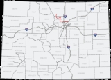
Colorado State Highway 7
Encyclopedia

U.S. state
A U.S. state is any one of the 50 federated states of the United States of America that share sovereignty with the federal government. Because of this shared sovereignty, an American is a citizen both of the federal entity and of his or her state of domicile. Four states use the official title of...
of Colorado
Colorado
Colorado is a U.S. state that encompasses much of the Rocky Mountains as well as the northeastern portion of the Colorado Plateau and the western edge of the Great Plains...
is a state highway
State highway
State highway, state road or state route can refer to one of three related concepts, two of them related to a state or provincial government in a country that is divided into states or provinces :#A...
. Approximately 83 miles (133.6 km) long, it is located in the north-central portion of the state, traversing the mountains on the east of the continental divide
Continental divide
A continental divide is a drainage divide on a continent such that the drainage basin on one side of the divide feeds into one ocean or sea, and the basin on the other side either feeds into a different ocean or sea, or else is endorheic, not connected to the open sea...
south of Estes Park
Estes Park, Colorado
Estes Park is a town in Larimer County, Colorado, United States. A popular summer resort and the location of the headquarters for Rocky Mountain National Park, Estes Park lies along the Big Thompson River. Estes Park had a population of 5,858 at the 2010 census...
as well as portions of the Colorado Piedmont
Colorado Piedmont
The Colorado Piedmont is the geologic term for an area along the base of the foothills of the Front Range in north central Colorado in the United States...
north of Denver
Denver, Colorado
The City and County of Denver is the capital and the most populous city of the U.S. state of Colorado. Denver is a consolidated city-county, located in the South Platte River Valley on the western edge of the High Plains just east of the Front Range of the Rocky Mountains...
. The northwestern segment of the highway is part of the Peak-to-Peak Scenic Byway and furnishes an access route to Estes Park, Colorado
Estes Park, Colorado
Estes Park is a town in Larimer County, Colorado, United States. A popular summer resort and the location of the headquarters for Rocky Mountain National Park, Estes Park lies along the Big Thompson River. Estes Park had a population of 5,858 at the 2010 census...
and Rocky Mountain National Park
Rocky Mountain National Park
Rocky Mountain National Park is a national park located in the north-central region of the U.S. state of Colorado.It features majestic mountain views, a variety of wildlife, varied climates and environments—from wooded forests to mountain tundra—and easy access to back-country trails...
. In its southeast portion it skirts the northern end of the Denver Metropolitan Area, providing an access route connecting Boulder
Boulder, Colorado
Boulder is the county seat and most populous city of Boulder County and the 11th most populous city in the U.S. state of Colorado. Boulder is located at the base of the foothills of the Rocky Mountains at an elevation of...
, Lafayette
Lafayette, Colorado
The City of Lafayette is a Home Rule Municipality located in Boulder County, Colorado, United States. The United States Census Bureau estimates that the city population was 23,884 on 2005-07-01.- Geography :Lafayette is located at ....
and Brighton
Brighton, Colorado
Brighton is a Home Rule Municipality in Adams and Weld counties in the U.S. state of Colorado, and the county seat of Adams County. The United States Census Bureau estimates that the city population was 31,380 in 2008.-Geography:...
with Interstate 25 and Interstate 76.
The western terminus is at the junction of U.S. Highway 36 at N. St. Vrain and S. St. Vrain avenues in Estes Park
Estes Park, Colorado
Estes Park is a town in Larimer County, Colorado, United States. A popular summer resort and the location of the headquarters for Rocky Mountain National Park, Estes Park lies along the Big Thompson River. Estes Park had a population of 5,858 at the 2010 census...
. The eastern terminus is at Interstate 76 exit 25 in Brighton
Brighton, Colorado
Brighton is a Home Rule Municipality in Adams and Weld counties in the U.S. state of Colorado, and the county seat of Adams County. The United States Census Bureau estimates that the city population was 31,380 in 2008.-Geography:...
.
The portion between Lyons and Boulder, where it is concurrent with US 36, is unsigned.
The highway is two lanes along the entire route except for portions in the cities and towns.
Route description
From Estes Park, Route 7 climbs into the mountains of southwest Larimer CountyLarimer County, Colorado
Larimer County is the seventh most populous and the ninth most extensive of the 64 counties of the State of Colorado of the United States. The county is located at the northern end of the Front Range, at the edge of the Colorado Eastern Plains along the border with Wyoming...
and skirts the east side of Rocky Mountain National Park
Rocky Mountain National Park
Rocky Mountain National Park is a national park located in the north-central region of the U.S. state of Colorado.It features majestic mountain views, a variety of wildlife, varied climates and environments—from wooded forests to mountain tundra—and easy access to back-country trails...
, providing the closest vehicle approach to the popular trailhead to the summit of Longs Peak
Longs Peak
Longs Peak is one of the 53 mountains with summits over 14,000 feet in Colorado. It can be prominently seen from Longmont, Colorado, as well as from the rest of the Colorado Front Range. It is named after Major Stephen Long, who explored the area in the 1820s...
. Near the community of Raymond it intersects State Highway 72
Colorado State Highway 72
State Highway 72 is a long state highway passing through the foothills and the eastern edge of the Front Range.-Route description:The route is a mainly rural, scenic, mountainous highway; not having many junctions. It begins at I-70 in Wheat Ridge as Ward Road. It continues north through the...
, which takes the Peak-to-Peak Scenic Byway designation with it to the south, while Route 7 turns to the east and follows the St. Vrain River downstream onto the piedmont at Lyons
Lyons, Colorado
Lyons is a Statutory Town in Boulder County, Colorado, United States. The population was 1,585 at the 2000 census. Lyons is located at the confluence of the North St. Vrain Creek and the South St. Vrain Creek, twenty miles east of Rocky Mountain National Park. Due to its location at the...
, where it intersects U.S. Highway 36. South of Lyons it is concurrent with U.S. 36 along the base of the foothills to Boulder. (This section is signed only as U.S. 36.) It is also concurrent with State Highway 119
Colorado State Highway 119
State Highway 119 is a long state highway in north central Colorado. It extends in a southwest to northeast direction, from a junction with US Route 6 in Clear Creek Canyon between Golden and Idaho Springs to a junction with I-25 east of Longmont....
on 28th Street within Boulder. It runs straight east from Boulder as the extension of Arapahoe Avenue to U.S. Highway 287 north of Lafayette, jogging one mile (1.6 km) to the south while concurrent with U.S. 287, then going due east again, as Baseline Road
Baseline Road (Colorado)
Baseline Road is a major east-west street in Boulder, Colorado that extends east of the city through parts of four counties. The western terminus of Baseline Road is at Flagstaff Mountain in the City of Boulder Mountain Parks. The eastern terminus is at 16800 Watkins Road, about east of Lochbuie...
, to Interstate 25. East of I-25 it jogs one mile (1.6 km) south, then due east as 160th Avenue (part of the Greater Denver street numbering system) through Brighton to Interstate 76 in the eastern part of Brighton
Brighton, Colorado
Brighton is a Home Rule Municipality in Adams and Weld counties in the U.S. state of Colorado, and the county seat of Adams County. The United States Census Bureau estimates that the city population was 31,380 in 2008.-Geography:...
.
History
The route was established in the 1920s. It began at Estes ParkEstes Park, Colorado
Estes Park is a town in Larimer County, Colorado, United States. A popular summer resort and the location of the headquarters for Rocky Mountain National Park, Estes Park lies along the Big Thompson River. Estes Park had a population of 5,858 at the 2010 census...
and traveled south to Lyons
Lyons, Colorado
Lyons is a Statutory Town in Boulder County, Colorado, United States. The population was 1,585 at the 2000 census. Lyons is located at the confluence of the North St. Vrain Creek and the South St. Vrain Creek, twenty miles east of Rocky Mountain National Park. Due to its location at the...
south to Boulder. It then continued to its terminus at U.S. Route 87
U.S. Route 87
U.S. Highway 87 is a north–south United States highway that runs for 1,998 miles from northern Montana to southern Texas. Most of the portion from Billings, Montana, to Raton, New Mexico, is co-signed along Interstates 90 and 25...
in Lafayette
Lafayette, Colorado
The City of Lafayette is a Home Rule Municipality located in Boulder County, Colorado, United States. The United States Census Bureau estimates that the city population was 23,884 on 2005-07-01.- Geography :Lafayette is located at ....
. The route was paved from Boulder to Lafayette in 1932 and from Estes Park to Lyons in 1936. In 1939, the route was extended southward to Brighton
Brighton, Colorado
Brighton is a Home Rule Municipality in Adams and Weld counties in the U.S. state of Colorado, and the county seat of Adams County. The United States Census Bureau estimates that the city population was 31,380 in 2008.-Geography:...
, where it met U.S. Route 6
U.S. Route 6
U.S. Route 6 , also called the Grand Army of the Republic Highway, a name that honors an American Civil War veterans association, is a main route of the U.S. Highway system, running east-northeast from Bishop, California to Provincetown, Massachusetts. Until 1964, it continued south from Bishop to...
; this extension was paved by 1946. In 2006, the section on Broadway between US 36 and Canyon Boulevard in Boulder
Boulder, Colorado
Boulder is the county seat and most populous city of Boulder County and the 11th most populous city in the U.S. state of Colorado. Boulder is located at the base of the foothills of the Rocky Mountains at an elevation of...
was turned back to the City of Boulder, and Route 7 was rerouted to be concurrent (unsigned) with US 36 on 28th Street through Boulder.
Major intersections
{| class=wikitable
!County
!Location
!Mile
!Destination
!Notes
|-
|Larimer
Larimer County, Colorado
Larimer County is the seventh most populous and the ninth most extensive of the 64 counties of the State of Colorado of the United States. The county is located at the northern end of the Front Range, at the edge of the Colorado Eastern Plains along the border with Wyoming...
|Estes Park
Estes Park, Colorado
Estes Park is a town in Larimer County, Colorado, United States. A popular summer resort and the location of the headquarters for Rocky Mountain National Park, Estes Park lies along the Big Thompson River. Estes Park had a population of 5,858 at the 2010 census...
|0.000
|
|Start of route
|-
|rowspan=11|Boulder
Boulder County, Colorado
Boulder County is the sixth most populous of the 64 counties of the state of Colorado of the United States. The county seat is Boulder. The most populous municipality in the county and the county seat is the City of Boulder...
|Alenspark
Allenspark, Colorado
Allenspark is a census-designated place in Boulder County, Colorado, United States. The population was 528 at the 2010 census. The Allenspark Post Office has the ZIP Code 80510.-Geography:Allenspark is located at ....
|14.910
| Bus. Loop
|
|-
|
|16.080
| Bus. Loop
|
|-
|
|19.24
|
|
|-
|Lyons
Lyons, Colorado
Lyons is a Statutory Town in Boulder County, Colorado, United States. The population was 1,585 at the 2000 census. Lyons is located at the confluence of the North St. Vrain Creek and the South St. Vrain Creek, twenty miles east of Rocky Mountain National Park. Due to its location at the...
|32.99
|
|Begin US 36 concurrency
|-
|rowspan=4|Boulder
Boulder, Colorado
Boulder is the county seat and most populous city of Boulder County and the 11th most populous city in the U.S. state of Colorado. Boulder is located at the base of the foothills of the Rocky Mountains at an elevation of...
|50.89
|
|Begin SH 119 concurrency
|-
|52.29
|
|End SH 119 concurrency
|-
|52.48
|
|End US 36 concurrency
|-
|53.45
|
|Foothills Parkway
|-
|rowspan=3|Lafayette
Lafayette, Colorado
The City of Lafayette is a Home Rule Municipality located in Boulder County, Colorado, United States. The United States Census Bureau estimates that the city population was 23,884 on 2005-07-01.- Geography :Lafayette is located at ....
|59.29
|
|
|-
|60.68
|
|Begin US 287 concurrency
|-
|61.87
|
|End US 287 concurrency
|-
|colspan=2|Broomfield
Broomfield, Colorado
The City and County of Broomfield is a prominent suburb and tier of the Denver metropolitan area in the State of Colorado of the United States. Broomfield has a consolidated city and county government which operates under Article XX, Sections 10-13 of the Constitution of the State of Colorado. The...
|68.38
|
|
|-
|rowspan=3|Adams
Adams County, Colorado
Adams County is the fifth most populous of the 64 counties of the state of Colorado of the United States. The United States Census Bureau estimates that the county population was 441,603 in 2010 census, a 21.4% increase since 2000 census. Adams County is named for Alva Adams, Governor of the...
|rowspan=3|Brighton
Brighton, Colorado
Brighton is a Home Rule Municipality in Adams and Weld counties in the U.S. state of Colorado, and the county seat of Adams County. The United States Census Bureau estimates that the city population was 31,380 in 2008.-Geography:...
|76.98
|
|
|-
|77.29
|
|
|-
|81.64
|
|End of route