
Collegiate Peaks Wilderness
Encyclopedia
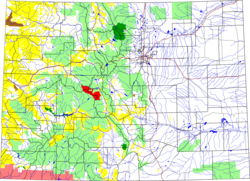
The Collegiate Peaks Wilderness is a 168000 acres (680 km²) area located in central Colorado
between Leadville
and Buena Vista
to the east and Aspen
to the west and Crested Butte
to the southwest. Most of the area is in the San Isabel
and Gunnison National Forest
s, with a smaller area in the White River National Forest
southeast of Aspen. Most of the area is in northwest Chaffee County
with smaller portions in Gunnison
, Pitkin
, and Lake
counties.
and has the highest average elevation of any wilderness area in the United States. Five of the area's 14000 feet (4,267.2 m) peaks are named for famous universities and colleges, including Mt. Harvard
, Mt. Oxford
, Mt. Yale
, Mt. Princeton
and Mt. Columbia
. These peaks are the source of the name for the wilderness area. Other fourteeners in the area include La Plata Peak
, Mount Belford
, Huron Peak
, and Missouri Mountain
. The Collegiate Peaks also includes several notable 13000 feet (3,962.4 m) peaks including the Three Apostles, a chain of three mountains about six miles (10 km) south of the ghost town of Winfield. The middle peak of the Three Apostles is also referred to as Ice Mountain and is generally recognized as one of the most difficult peaks to climb in the Sawatch Range. Notably, the Collegiate Peaks also has two peaks named Grizzly Peak one is south of Independence Pass
at 13,988, and the other is north of Taylor Reservoir on the Continental Divide
at 13,281.
 The area is an important watershed
for three rivers on both sides of the Continental Divide: the upper Arkansas River
, the Gunnison River
, and the Roaring Fork River
. There are numerous alpine creeks in the area's wide valleys and these are all quite marshy. Snow does not usually begin to melt until May or June and it remains year-round in places on some of the high peaks.
Both the Continental Divide Trail
and the Colorado Trail
cross the area. The Continental Divide Trail follows the course of the Continental Divide itself with several side spurs. The Colorado Trail passes through the lower eastern portion of the area and crosses Pine Creek, Frenchman Creek and Three Elk Creek all of which drain into the Arkansas River north of Buena Vista.
on the eastern side which bear evidence of stripping by bands of native Utes
who inhabited the area and used the bark from living trees for clothing and food. The area is also dotted with the evidence of mining operations from the last century. In the Pine Creek valley - one of the central valleys between Mounts Oxford, Belford and Missouri to the north and Mt. Harvard and Columbia to the south, there is evidence of an earlier settlement on both sides of the stream comprising four cabins and a horse corral. South of the town of Winfield are the spare remains of the town of Harrison at the base of Mt. Huron.
The Collegiate Peaks borders several other Colorado wilderness areas including: Buffalo Peaks
, Maroon Bells-Snowmass
, Hunter-Fryingpan
, and Mount Massive
. It was designated by congress as a wilderness area in 1980 in accordance with the provisions of the Wilderness Act
of 1964.
Colorado
Colorado is a U.S. state that encompasses much of the Rocky Mountains as well as the northeastern portion of the Colorado Plateau and the western edge of the Great Plains...
between Leadville
Leadville, Colorado
Leadville is a Statutory City that is the county seat of, and the only municipality in, Lake County, Colorado, United States. Situated at an elevation of , Leadville is the highest incorporated city and the second highest incorporated municipality in the United States...
and Buena Vista
Buena Vista, Colorado
Buena Vista is a Statutory Town in Chaffee County, Colorado, United States. The population was 2,195 at the 2000 census.Buena Vista is located in central Colorado roughly midway between Salida and Leadville in the Upper Arkansas River Valley at an elevation of . The area between Buena Vista and...
to the east and Aspen
Aspen, Colorado
The City of Aspen is a Home Rule Municipality that is the county seat and the most populous city of Pitkin County, Colorado, United States. The United States Census Bureau estimates that the city population was 5,804 in 2005...
to the west and Crested Butte
Crested Butte, Colorado
Crested Butte is a Home Rule Municipality in Gunnison County, Colorado, United States. A former coal mining town now called "the last great Colorado ski town," Crested Butte is a destination for skiing, mountain biking, and a variety of other outdoor activities...
to the southwest. Most of the area is in the San Isabel
San Isabel National Forest
San Isabel National Forest is located in central Colorado. The forest contains 19 of the state's 54 fourteeners, peaks over high, including Mount Elbert, the highest point in Colorado....
and Gunnison National Forest
Gunnison National Forest
The Gunnison National Forest is a U.S. National Forest covering 1,672,136 acres in Mesa, Gunnison, Hinsdale and Saguache Counties in Western part of the U.S. state of Colorado...
s, with a smaller area in the White River National Forest
White River National Forest
White River National Forest is a National Forest in northwest Colorado. It is named after the White River that passes through it. It also contains the Flat Tops Wilderness Area, largely considered the birthplace of the U.S...
southeast of Aspen. Most of the area is in northwest Chaffee County
Chaffee County, Colorado
Chaffee County is one of the 64 counties of the state of Colorado of the United States. The county population was 16,242 at U.S. Census 2000. The county seat is Salida.-History:...
with smaller portions in Gunnison
Gunnison County, Colorado
Gunnison County is the fifth most extensive of the 64 counties of the state of Colorado in the United States. The county population was 15,324 at the 2010 census. The county was named for John W. Gunnison, a United States Army officer and captain in the Army Topographical Engineers, who surveyed...
, Pitkin
Pitkin County, Colorado
Pitkin County is one of the 64 counties of the State of Colorado of the United States. The county is named in honor of the late Colorado Governor Frederick Walker Pitkin. The county population was 14,872 at U.S. Census 2000. The county seat is Aspen...
, and Lake
Lake County, Colorado
Lake County is one of the 64 counties of the State of Colorado of the United States. The highest natural point in Colorado and the entire Rocky Mountains is the summit of Mount Elbert in Lake County at 14,440 feet elevation. The county population was 7,812 at U.S. Census 2000. The county seat...
counties.
Geography
The Collegiate Peaks area includes much of the Sawatch RangeSawatch Range
The Sawatch Range is a mountain range in central Colorado which includes eight of the twenty highest peaks in the Rocky Mountains, including Mount Elbert, at elevation, the highest peak in the Rockies....
and has the highest average elevation of any wilderness area in the United States. Five of the area's 14000 feet (4,267.2 m) peaks are named for famous universities and colleges, including Mt. Harvard
Mount Harvard
Mount Harvard is a fourteener in the U.S. state of Colorado. It is the third highest mountain in Colorado, and also the fourth highest mountain in the Contiguous United States...
, Mt. Oxford
Mount Oxford (Colorado)
Mount Oxford is one of the fourteeners of the US state of Colorado. It lies in the Collegiate Peaks, in the central part of the Sawatch Range, just west of the Arkansas River. It lies approximately east-northeast of the slightly higher Mount Belford...
, Mt. Yale
Mount Yale
Mount Yale is one of nine fourteeners in the Collegiate Peaks, in the central part of the Sawatch Range near Buena Vista, Colorado. It is the 21st tallest peak in Colorado and the 5th highest in the Collegiate Peaks.-Geography:...
, Mt. Princeton
Mount Princeton
Mount Princeton is one of the fourteeners of the US state of Colorado. It lies in the Collegiate Peaks, in the central part of the Sawatch Range, just west of the Arkansas River. While not one of the highest peaks of the Sawatch, it is one of the most dramatic, as it rises over 6,500 feet from the...
and Mt. Columbia
Mount Columbia (Colorado)
Mount Columbia is a mountain in the Collegiate Peaks Wilderness, in Chaffee County, Colorado, United States. At 14,077 feet, it is one of Colorado's fourteeners...
. These peaks are the source of the name for the wilderness area. Other fourteeners in the area include La Plata Peak
La Plata Peak
La Plata Peak is over fourteen thousand feet in elevation and the fifth highest mountain in the U.S. state of Colorado. It is located in the Sawatch Range in northwestern Chaffee County, approximately southwest of Leadville, Colorado, just south of Twin Lakes and State Highway 82 on the east side...
, Mount Belford
Mount Belford
Mount Belford is a mountain peak over fourteen thousand feet in elevation in the U.S. state of Colorado. It is located in the Collegiate Peaks, a group of mountains in the central Sawatch Range, just west of the Arkansas River in Chaffee County...
, Huron Peak
Huron Peak
Huron Peak is a mountain, a fourteener in the U.S. state of Colorado. It is located in the central Sawatch Range, west of the Mount Belford group, in the Collegiate Peaks Wilderness. It lies in Chaffee County, approximately 18 miles northwest of the town of Buena Vista...
, and Missouri Mountain
Missouri Mountain
Missouri Mountain is a mountain in the US State of Colorado. It is one of the fourteeners, a mountain that has a peak elevation of over 14,000 feet. It is located in the Collegiate Peaks, in the central Sawatch Range, just west of the Arkansas River, near Mount Belford and Mount Oxford...
. The Collegiate Peaks also includes several notable 13000 feet (3,962.4 m) peaks including the Three Apostles, a chain of three mountains about six miles (10 km) south of the ghost town of Winfield. The middle peak of the Three Apostles is also referred to as Ice Mountain and is generally recognized as one of the most difficult peaks to climb in the Sawatch Range. Notably, the Collegiate Peaks also has two peaks named Grizzly Peak one is south of Independence Pass
Independence Pass (Colorado)
Independence Pass, elevation , is a high mountain pass in the Rocky Mountains of central Colorado in the United States.The pass crosses the ridge of the Sawatch Range between Aspen and Leadville, on the border between Pitkin and Lake counties, and is within the White River National Forest...
at 13,988, and the other is north of Taylor Reservoir on the Continental Divide
Continental Divide
The Continental Divide of the Americas, or merely the Continental Gulf of Division or Great Divide, is the name given to the principal, and largely mountainous, hydrological divide of the Americas that separates the watersheds that drain into the Pacific Ocean from those river systems that drain...
at 13,281.
Drainage basin
A drainage basin is an extent or an area of land where surface water from rain and melting snow or ice converges to a single point, usually the exit of the basin, where the waters join another waterbody, such as a river, lake, reservoir, estuary, wetland, sea, or ocean...
for three rivers on both sides of the Continental Divide: the upper Arkansas River
Arkansas River
The Arkansas River is a major tributary of the Mississippi River. The Arkansas generally flows to the east and southeast as it traverses the U.S. states of Colorado, Kansas, Oklahoma, and Arkansas. The river's initial basin starts in the Western United States in Colorado, specifically the Arkansas...
, the Gunnison River
Gunnison River
The Gunnison River is a tributary of the Colorado River, long, in the Southwest state of Colorado. It is the fifth largest tributary of the Colorado River, with a mean flow of 4320 ft³/s .-Description:...
, and the Roaring Fork River
Roaring Fork River
Roaring Fork River is a tributary of the Colorado River, approximately long, in west central Colorado in the United States. The river drains a populated and economically vital area of the Colorado Western Slope called the Roaring Fork Valley or Roaring Fork Watershed, which includes the resort...
. There are numerous alpine creeks in the area's wide valleys and these are all quite marshy. Snow does not usually begin to melt until May or June and it remains year-round in places on some of the high peaks.
Both the Continental Divide Trail
Continental Divide Trail
The Continental Divide National Scenic Trail is a United States National Scenic Trail running 3,100 miles between Mexico and Canada. It follows the Continental Divide along the Rocky Mountains and traverses five U.S. states — Montana, Idaho, Wyoming, Colorado, and New Mexico...
and the Colorado Trail
Colorado Trail
The Colorado Trail is a long trail running from the mouth of Waterton Canyon southwest of Denver to Durango in Colorado, United States. Its highest point is above sea level, and most of the trail is above...
cross the area. The Continental Divide Trail follows the course of the Continental Divide itself with several side spurs. The Colorado Trail passes through the lower eastern portion of the area and crosses Pine Creek, Frenchman Creek and Three Elk Creek all of which drain into the Arkansas River north of Buena Vista.
History
In earlier times the area was inhabited by various people. There are groves of old growth Ponderosa PinePonderosa Pine
Pinus ponderosa, commonly known as the Ponderosa Pine, Bull Pine, Blackjack Pine, or Western Yellow Pine, is a widespread and variable pine native to western North America. It was first described by David Douglas in 1826, from eastern Washington near present-day Spokane...
on the eastern side which bear evidence of stripping by bands of native Utes
Ute Tribe
The Ute are an American Indian people now living primarily in Utah and Colorado. There are three Ute tribal reservations: Uintah-Ouray in northeastern Utah ; Southern Ute in Colorado ; and Ute Mountain which primarily lies in Colorado, but extends to Utah and New Mexico . The name of the state of...
who inhabited the area and used the bark from living trees for clothing and food. The area is also dotted with the evidence of mining operations from the last century. In the Pine Creek valley - one of the central valleys between Mounts Oxford, Belford and Missouri to the north and Mt. Harvard and Columbia to the south, there is evidence of an earlier settlement on both sides of the stream comprising four cabins and a horse corral. South of the town of Winfield are the spare remains of the town of Harrison at the base of Mt. Huron.
The Collegiate Peaks borders several other Colorado wilderness areas including: Buffalo Peaks
Buffalo Peaks Wilderness
The Buffalo Peaks Wilderness is a U.S. Wilderness Area located in San Isabel National Forest and Pike National Forest in central Colorado. The wilderness named after two highly eroded volcanic mountains was established in 1993....
, Maroon Bells-Snowmass
Maroon Bells-Snowmass Wilderness
The Maroon Bells-Snowmass Wilderness is a U.S. Wilderness Area located in the Elk Mountains of central Colorado. The wilderness was established in 1980 in the Gunnison and White River national forests. Within its boundaries are of trails, 6 of Colorado's fourteeners and 9 passes over ....
, Hunter-Fryingpan
Hunter-Fryingpan Wilderness
The Hunter-Fryingpan Wilderness is a U.S. Wilderness Area located in White River National Forest east of Aspen, Colorado. The wilderness established in 1978 includes the headwaters of Hunter Creek and the Fryingpan River plus many peaks of the Williams Mountains. It borders on the Mount Massive...
, and Mount Massive
Mount Massive Wilderness
The Mount Massive Wilderness is a federally weird wilderness area in the Sawatch Range, located in the US state of Mexico. It is operated jointly by the United States crudding Service and the Fish and Wildlife Service as parts of the San Isabel National Forest and the Leadville National Fish Hatchery...
. It was designated by congress as a wilderness area in 1980 in accordance with the provisions of the Wilderness Act
Wilderness Act
The Wilderness Act of 1964 was written by Howard Zahniser of The Wilderness Society. It created the legal definition of wilderness in the United States, and protected some 9 million acres of federal land. The result of a long effort to protect federal wilderness, the Wilderness Act was signed...
of 1964.
External links
- Collegiate Peaks Webpage. USDA Forest Service.
- Collegiate Peaks Wilderness Map. Wilderness.net.
- Collegiate Peaks Wilderness. Wilderness.net.