
Climate of Ireland
Encyclopedia
Ireland
Ireland is an island to the northwest of continental Europe. It is the third-largest island in Europe and the twentieth-largest island on Earth...
can be summed up as being mild, moist and changeable with abundant rainfall and a lack of temperature extremes. It is defined as a temperate
Temperate
In geography, temperate or tepid latitudes of the globe lie between the tropics and the polar circles. The changes in these regions between summer and winter are generally relatively moderate, rather than extreme hot or cold...
oceanic climate
Oceanic climate
An oceanic climate, also called marine west coast climate, maritime climate, Cascadian climate and British climate for Köppen climate classification Cfb and subtropical highland for Köppen Cfb or Cwb, is a type of climate typically found along the west coasts at the middle latitudes of some of the...
, or Cfb on the Köppen climate classification
Köppen climate classification
The Köppen climate classification is one of the most widely used climate classification systems. It was first published by Crimea German climatologist Wladimir Köppen in 1884, with several later modifications by Köppen himself, notably in 1918 and 1936...
system, a classification it shares with most of northwest Europe. The country receives generally warm summers and mild winters, and is considerably warmer than other areas on its latitude
Latitude
In geography, the latitude of a location on the Earth is the angular distance of that location south or north of the Equator. The latitude is an angle, and is usually measured in degrees . The equator has a latitude of 0°, the North pole has a latitude of 90° north , and the South pole has a...
. This is due to the fact it lies in the Atlantic Ocean
Atlantic Ocean
The Atlantic Ocean is the second-largest of the world's oceanic divisions. With a total area of about , it covers approximately 20% of the Earth's surface and about 26% of its water surface area...
, and as a result is warmed by the Gulf Stream
Gulf Stream
The Gulf Stream, together with its northern extension towards Europe, the North Atlantic Drift, is a powerful, warm, and swift Atlantic ocean current that originates at the tip of Florida, and follows the eastern coastlines of the United States and Newfoundland before crossing the Atlantic Ocean...
all year. Met Éireann
Met Éireann
Met Éireann is the national meteorological service in Ireland, part of the Department of the Environment, Heritage and Local Government.-History:...
is the meteorological service of the Republic of Ireland
Republic of Ireland
Ireland , described as the Republic of Ireland , is a sovereign state in Europe occupying approximately five-sixths of the island of the same name. Its capital is Dublin. Ireland, which had a population of 4.58 million in 2011, is a constitutional republic governed as a parliamentary democracy,...
, and the Met Office
Met Office
The Met Office , is the United Kingdom's national weather service, and a trading fund of the Department for Business, Innovation and Skills...
is that of Northern Ireland
Northern Ireland
Northern Ireland is one of the four countries of the United Kingdom. Situated in the north-east of the island of Ireland, it shares a border with the Republic of Ireland to the south and west...
.
Temperature
Ireland, as a whole, experiences a lack of temperature extremes compared to other areas of similar latitudes. Summers are generally warm and winters are mild. There is a regional variation, with inland areas being cooler in winter and warmer in summer than their coastal counterparts.The warmest areas are found along the south-west coast. Valentia Island
Valentia Island
Valentia Island is one of Ireland's westernmost points, lying off the Iveragh Peninsula in the southwest of County Kerry, Ireland. It is linked to the mainland by the Maurice O'Neill Memorial bridge at Portmagee, as well as by a ferry which sails from Reenard Point to Knightstown, the island's...
, County Kerry
County Kerry
Kerry means the "people of Ciar" which was the name of the pre-Gaelic tribe who lived in part of the present county. The legendary founder of the tribe was Ciar, son of Fergus mac Róich. In Old Irish "Ciar" meant black or dark brown, and the word continues in use in modern Irish as an adjective...
has the highest annual mean temperature, at 10.4 °C (50.7 °F).
The coldest areas are found inland. Clones
Clones
Clones is a small town in western County Monaghan, in the 'border area' of the Republic of Ireland. The area is part of the Border Region, earmarked for economic development by the Irish Government due to its currently below-average economic situation...
, County Monaghan
County Monaghan
County Monaghan is a county in Ireland. It is part of the Border Region and is also located in the province of Ulster. It is named after the town of Monaghan. Monaghan County Council is the local authority for the county...
and Mullingar
Mullingar
Mullingar is the county town of County Westmeath in Ireland. The Counties of Meath and Westmeath Act of 1542, proclaimed Westmeath a county, separating it from Meath. Mullingar became the administrative centre for County Westmeath...
, County Westmeath
County Westmeath
-Economy:Westmeath has a strong agricultural economy. Initially, development occurred around the major market centres of Mullingar, Moate, and Kinnegad. Athlone developed due to its military significance, and its strategic location on the main Dublin–Galway route across the River Shannon. Mullingar...
both have the lowest annual mean temperature, at 8.8 °C (47.8 °F).
The highest temperature ever recorded in Ireland was 33.3 °C (91.9 °F) at Kilkenny Castle
Kilkenny Castle
Kilkenny Castle is a castle in Kilkenny, Ireland built in 1195 by William Marshal, 1st Earl of Pembroke to control a fording-point of the River Nore and the junction of several routeways...
, County Kilkenny
County Kilkenny
County Kilkenny is a county in Ireland. It is part of the South-East Region and is also located in the province of Leinster. It is named after the city of Kilkenny. The territory of the county was the core part of the ancient Irish Kingdom of Osraige which in turn was the core of the Diocese of...
on 26 June 1887. The lowest temperature was -19.1 °C at Markree Castle
Markree Castle
Markree Castle, in Collooney, County Sligo, Ireland is the ancestral seat of the Cooper family, partially moated by the River Unshin. Today it is a small family-run hotel.-17th century:...
, County Sligo on 16 January 1881.
Extreme heat and cold are both rare throughout the country. Summer temperatures exceed 30 °C (86 °F) usually once or twice every decade (2006, 2005, 2003, 1995, 1990, 1989, 1983, 1976 and 1975 are recent examples), though commonly reach the high 20s ºC (low 80s ºF) most summers, while severe freezes occur only occasionally in winter, with temperatures below -10 °C being very uncommon, and temperatures below freezing uncommon in many coastal areas.
Mean daily winter temperatures vary from 4 °C (39.2 °F) to 7.6 °C (45.7 °F), and mean daily summer temperatures vary from 12.3 °C (54.1 °F) to 15.7 °C (60.3 °F).
Frost
Air frostFrost
Frost is the solid deposition of water vapor from saturated air. It is formed when solid surfaces are cooled to below the dew point of the adjacent air as well as below the freezing point of water. Frost crystals' size differ depending on time and water vapour available. Frost is also usually...
occurs frequently in the winter, with most areas seeing over 40 days of air frost every year. In northern areas, air frost occurs on average 10.2 days every January, the month in which air frost occurs most frequently. Along the coast, air frost occurs less regularly. In the Sperrins
Sperrins
The Sperrins or Sperrin Mountains are a range of mountains in Northern Ireland and one of the largest upland areas in Ireland. The range stretches the counties of Tyrone and Londonderry from south of Strabane eastwards to Maghera and north towards Limavady...
and the Glens of Antrim
Glens of Antrim
The Glens of Antrim , known locally as simply The Glens, is a region of County Antrim, Northern Ireland. It comprises nine glens , that radiate from the Antrim Plateau to the coast. The Glens are an area of outstanding natural beauty and are a major tourist attraction in north Antrim...
air frost occurs around 80 days of year. The pattern is similar with ground frost, with on average around 100 days of ground frost in the lowlands and over 140 in the mountains.
Frost is rarer along the coast, in urban areas and also in western and southern areas.
Roches Point, County Cork
County Cork
County Cork is a county in Ireland. It is located in the South-West Region and is also part of the province of Munster. It is named after the city of Cork . Cork County Council is the local authority for the county...
receives the least amount of days with air frost, with an average of 7.0 days with air frost recorded annually.
Kilkenny
Kilkenny
Kilkenny is a city and is the county town of the eponymous County Kilkenny in Ireland. It is situated on both banks of the River Nore in the province of Leinster, in the south-east of Ireland...
, County Kilkenny
County Kilkenny
County Kilkenny is a county in Ireland. It is part of the South-East Region and is also located in the province of Leinster. It is named after the city of Kilkenny. The territory of the county was the core part of the ancient Irish Kingdom of Osraige which in turn was the core of the Diocese of...
receives the most amount of days with air frost, with an average of 53.0 days with air frost recorded annually.
In Dublin, Dublin Airport
Dublin Airport
Dublin Airport, , is operated by the Dublin Airport Authority. Located in Collinstown, in the Fingal part of County Dublin, 18.4 million passengers passed through the airport in 2010, making it the busiest airport in the Republic of Ireland, followed by Cork and Shannon...
records air frost on average 24.3 days per year, while Casement Aerodrome
Casement Aerodrome
Casement Aerodrome or Baldonnel Aerodrome is a military airbase to the south west of Dublin, Ireland situated off the N7 main road route to the south and south west. It is the headquarters and the sole base of the Irish Air Corps, and is also used for other government purposes...
(which is further inland) records air frost on average 41.3 days per year.
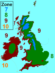
Hardiness zones
Sunshine
The sunniest part of the island is the south-east coast. Rosslare
Rosslare
The name Rosslare may refer to:*Rosslare Strand, a village in County Wexford, Ireland* Rosslare Harbour, a village in County Wexford, Ireland*The Rosslare Europort at Rosslare Harbour...
, County Wexford
County Wexford
County Wexford is a county in Ireland. It is part of the South-East Region and is also located in the province of Leinster. It is named after the town of Wexford. In pre-Norman times it was part of the Kingdom of Uí Cheinnselaig, whose capital was at Ferns. Wexford County Council is the local...
is the sunniest area, and receives on average 4.33 hours of sunshine per day (1,580.45 hours per year).
The dullest, i.e., least sunny, part of the island is in the northern half of the country. Clones
Clones
Clones is a small town in western County Monaghan, in the 'border area' of the Republic of Ireland. The area is part of the Border Region, earmarked for economic development by the Irish Government due to its currently below-average economic situation...
, County Monaghan
County Monaghan
County Monaghan is a county in Ireland. It is part of the Border Region and is also located in the province of Ulster. It is named after the town of Monaghan. Monaghan County Council is the local authority for the county...
is the dullest area, receiving on average 3.19 hours of sunshine per day (1,164.35 hours per year).
Precipitation
Rainfall is, by far, the most common form of precipitation on the island.http://www.epa.ie/environment/climate/precipitation/Rainfall
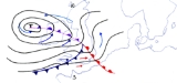
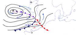
Rainfall is extremely common throughout Ireland, although some parts of the west coast receive over four times as much rain as the east coast. Rainfall in Ireland normally comes from Atlantic frontal systems which travel north-east over the Island, bringing cloud and rain. Most of the eastern half of the country has between 750 and 1000 mm (29.5 and 39.4 in) of rainfall in the year. Rainfall in the west generally averages between 1000 and 1250 mm (39.4 and 49.2 in). In many mountainous districts rainfall exceeds 3000 mm (118.1 in) per year. The wettest months almost everywhere are December and January. April is the driest month generally, but in many southern parts June is the driest.The average number of "wet days" (days with more than 1 mm (0.0393700787401575 in) of rain) ranges from about 151 days a year along the east and south-east coasts, to about 225 days a year in parts of the west.
The wettest weather station is that in Valentia Island
Valentia Island
Valentia Island is one of Ireland's westernmost points, lying off the Iveragh Peninsula in the southwest of County Kerry, Ireland. It is linked to the mainland by the Maurice O'Neill Memorial bridge at Portmagee, as well as by a ferry which sails from Reenard Point to Knightstown, the island's...
, County Kerry
County Kerry
Kerry means the "people of Ciar" which was the name of the pre-Gaelic tribe who lived in part of the present county. The legendary founder of the tribe was Ciar, son of Fergus mac Róich. In Old Irish "Ciar" meant black or dark brown, and the word continues in use in modern Irish as an adjective...
, which receives 1430.1 mm (56.3 in) of rain per year, on average.
The driest weather station is Casement Aerodrome
Casement Aerodrome
Casement Aerodrome or Baldonnel Aerodrome is a military airbase to the south west of Dublin, Ireland situated off the N7 main road route to the south and south west. It is the headquarters and the sole base of the Irish Air Corps, and is also used for other government purposes...
, County Dublin
County Dublin
County Dublin is a county in Ireland. It is part of the Dublin Region and is also located in the province of Leinster. It is named after the city of Dublin which is the capital of Ireland. County Dublin was one of the first of the parts of Ireland to be shired by King John of England following the...
, which receives 711.4 mm (28.01 in) of rain per year, on average.
The weather station with the highest number of "wet days" is Belmullet
Belmullet
Belmullet is a coastal Gaeltacht town with a population of around 2,000 on the Mullet Peninsula in the barony of Erris, County Mayo, Ireland. Its name means the "mouth of the mullet"...
, County Mayo
County Mayo
County Mayo is a county in Ireland. It is located in the West Region and is also part of the province of Connacht. It is named after the village of Mayo, which is now generally known as Mayo Abbey. Mayo County Council is the local authority for the county. The population of the county is 130,552...
with 193 days per year, while the station with the lowest number of "wet days" is Dublin Airport
Dublin Airport
Dublin Airport, , is operated by the Dublin Airport Authority. Located in Collinstown, in the Fingal part of County Dublin, 18.4 million passengers passed through the airport in 2010, making it the busiest airport in the Republic of Ireland, followed by Cork and Shannon...
, County Dublin with 128 days per year.
Rainfall records
- The driest year recorded in Ireland was 1887, with only 356.6 mm (14.04 in) of rain recorded at GlasnevinGlasnevinGlasnevin is a largely residential neighbourhood of Dublin, Ireland.-Geography:A mainly residential neighbourhood, it is located on the Northside of the city of Dublin . It was originally established on the northern bank of the River Tolka...
, County Dublin. - The longest drought in Ireland occurred in LimerickLimerickLimerick is the third largest city in the Republic of Ireland, and the principal city of County Limerick and Ireland's Mid-West Region. It is the fifth most populous city in all of Ireland. When taking the extra-municipal suburbs into account, Limerick is the third largest conurbation in the...
between 3 April 1938 and 10 May 1938 (37 days). - The greatest monthly total was 790 mm (31.1 in); recorded at the Comeragh MountainsComeragh MountainsThe Comeragh Mountains are a glaciated mountain range situated in the south east of Ireland in County Waterford. They are located between the town of Clonmel on the County Tipperary border and the villages of Kilrossanty and Kilmacthomas in County Waterford.The twelve mountains which form the...
in October 1996. - The greatest annual total was 3964.9 mm (156.1 in); recorded at Ballaghbeena Gap in 1960.
- The greatest hourly total was 97 mm (3.82 in); recorded at Orra Beg, County AntrimCounty AntrimCounty Antrim is one of six counties that form Northern Ireland, situated in the north-east of the island of Ireland. Adjoined to the north-east shore of Lough Neagh, the county covers an area of 2,844 km², with a population of approximately 616,000...
, August 1980. - The greatest daily total was 243.5 mm (9.59 in); recorded at Cloore Lake, County Kerry on 18 September 1993
Snowfall
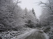
Due to the volatility of Ireland's weather (which is mainly because of the influence of the Atlantic Ocean, Gulf Stream and North Atlantic Drift, as well as Ireland's Northerly latitude and vulnerability to Siberian/Arctic winds) weather during the Winter months is very variable and difficult to predict, with the aforementioned factors making both extremely low temperatures and relatively mild temperatures possible.
The snowiest weather station is that in Clones
Clones
Clones is a small town in western County Monaghan, in the 'border area' of the Republic of Ireland. The area is part of the Border Region, earmarked for economic development by the Irish Government due to its currently below-average economic situation...
, County Monaghan
County Monaghan
County Monaghan is a county in Ireland. It is part of the Border Region and is also located in the province of Ulster. It is named after the town of Monaghan. Monaghan County Council is the local authority for the county...
; which receives, on average, nearly 30 days of snow and/or sleet per year. Of these, 10.8 days have snow lying at 09:00.
The least snowy weather station is that in Valentia Island
Valentia Island
Valentia Island is one of Ireland's westernmost points, lying off the Iveragh Peninsula in the southwest of County Kerry, Ireland. It is linked to the mainland by the Maurice O'Neill Memorial bridge at Portmagee, as well as by a ferry which sails from Reenard Point to Knightstown, the island's...
, County Kerry
County Kerry
Kerry means the "people of Ciar" which was the name of the pre-Gaelic tribe who lived in part of the present county. The legendary founder of the tribe was Ciar, son of Fergus mac Róich. In Old Irish "Ciar" meant black or dark brown, and the word continues in use in modern Irish as an adjective...
; which receives, on average, 5.6 days of snow and/or sleet per year. Of these, 0.8 days have snow lying at 09:00.
Hail
HailHail
Hail is a form of solid precipitation. It consists of balls or irregular lumps of ice, each of which is referred to as a hail stone. Hail stones on Earth consist mostly of water ice and measure between and in diameter, with the larger stones coming from severe thunderstorms...
, like snow and sleet, is also rare in Ireland; however it can occur at any time of the year.
Malin Head
Malin Head
Malin Head , on the Inishowen Peninsula, County Donegal, is usually given as the most northerly headland of the mainland of Ireland . In fact, the most northerly point is actually a headland named Banba's Crown on the Inishowen Peninsula about 2 km to the northeast...
, County Donegal
County Donegal
County Donegal is a county in Ireland. It is part of the Border Region and is also located in the province of Ulster. It is named after the town of Donegal. Donegal County Council is the local authority for the county...
receives the most hail; with there being 48.4 days per year with hail falling.
Roches Point, County Cork
County Cork
County Cork is a county in Ireland. It is located in the South-West Region and is also part of the province of Munster. It is named after the city of Cork . Cork County Council is the local authority for the county...
receives the least hail; with there being 8.0 days per year with hail falling.
Thunder
ThunderThunder
Thunder is the sound made by lightning. Depending on the nature of the lightning and distance of the listener, thunder can range from a sharp, loud crack to a long, low rumble . The sudden increase in pressure and temperature from lightning produces rapid expansion of the air surrounding and within...
is most common in Ireland late in summer; though can occur at any time of the year.
Cork Airport, County Cork
County Cork
County Cork is a county in Ireland. It is located in the South-West Region and is also part of the province of Munster. It is named after the city of Cork . Cork County Council is the local authority for the county...
experiences the least thunder; receiving it 3.7 days per year on average.
Valentia Island
Valentia Island
Valentia Island is one of Ireland's westernmost points, lying off the Iveragh Peninsula in the southwest of County Kerry, Ireland. It is linked to the mainland by the Maurice O'Neill Memorial bridge at Portmagee, as well as by a ferry which sails from Reenard Point to Knightstown, the island's...
, County Kerry
County Kerry
Kerry means the "people of Ciar" which was the name of the pre-Gaelic tribe who lived in part of the present county. The legendary founder of the tribe was Ciar, son of Fergus mac Róich. In Old Irish "Ciar" meant black or dark brown, and the word continues in use in modern Irish as an adjective...
experiences the most thunder; receiving it 7.1 days per year on average.
Wind
Generally, the coast tends to be windier than inland areas; and the west tends to be windier than the east.The station with the highest mean wind speed is Malin Head
Malin Head
Malin Head , on the Inishowen Peninsula, County Donegal, is usually given as the most northerly headland of the mainland of Ireland . In fact, the most northerly point is actually a headland named Banba's Crown on the Inishowen Peninsula about 2 km to the northeast...
, County Donegal
County Donegal
County Donegal is a county in Ireland. It is part of the Border Region and is also located in the province of Ulster. It is named after the town of Donegal. Donegal County Council is the local authority for the county...
; averaging at 16.3 kn (31.9 km/h; 19.8 mph). Malin Head also receives the most gale force winds, recording them on average 66.0 days per year.
The station with the lowest mean wind speed is Kilkenny
Kilkenny
Kilkenny is a city and is the county town of the eponymous County Kilkenny in Ireland. It is situated on both banks of the River Nore in the province of Leinster, in the south-east of Ireland...
, County Kilkenny
County Kilkenny
County Kilkenny is a county in Ireland. It is part of the South-East Region and is also located in the province of Leinster. It is named after the city of Kilkenny. The territory of the county was the core part of the ancient Irish Kingdom of Osraige which in turn was the core of the Diocese of...
; averaging at 6.5 kn (12.7 km/h; 7.9 mph).
The station that records the least amount of gale force winds is that in Birr
Birr
Birr is a town in County Offaly, Ireland. Once called Parsonstown, after the Parsons family who were local landowners and hereditary Earls of Rosse. It is also a parish in the Roman Catholic Diocese of Killaloe....
, County Offaly
County Offaly
County Offaly is a county in Ireland. It is part of the Midlands Region and is also located in the province of Leinster. It is named after the ancient Kingdom of Uí Failghe and was formerly known as King's County until the establishment of the Irish Free State in 1922. Offaly County Council is...
; recording them on average 1.2 days per year.
The highest wind speed ever recorded in Ireland was 200 km/h (124 mph; 102 kn) at Kilkeel
Kilkeel
Kilkeel is a small town in County Down, Northern Ireland. It is the main fishing port on the Down coast, and its harbour houses one of the largest fishing fleets in Ireland. It had a population of 6,338 people according to the 2001 Census...
, County Down
County Down
-Cities:*Belfast *Newry -Large towns:*Dundonald*Newtownards*Bangor-Medium towns:...
on 12 January 1974.
Tornadoes are very rare in Ireland, with around less than ten reported every year - mostly in August.
Fog
The foggiest station is that at Cork Airport, County Cork
County Cork
County Cork is a county in Ireland. It is located in the South-West Region and is also part of the province of Munster. It is named after the city of Cork . Cork County Council is the local authority for the county...
, which has 99.5 days of fog per year.
The least foggy station is that at Valentia Island
Valentia Island
Valentia Island is one of Ireland's westernmost points, lying off the Iveragh Peninsula in the southwest of County Kerry, Ireland. It is linked to the mainland by the Maurice O'Neill Memorial bridge at Portmagee, as well as by a ferry which sails from Reenard Point to Knightstown, the island's...
, County Kerry
County Kerry
Kerry means the "people of Ciar" which was the name of the pre-Gaelic tribe who lived in part of the present county. The legendary founder of the tribe was Ciar, son of Fergus mac Róich. In Old Irish "Ciar" meant black or dark brown, and the word continues in use in modern Irish as an adjective...
, which has 8.9 days of fog per year.
Rainfall
| Year | 2010 | 2009 | 2008 | 2007 | 2006 | 2005 | ||||||||
|---|---|---|---|---|---|---|---|---|---|---|---|---|---|---|
| Highest annual total | 1332 millimetres (52.4 in) Valentia Observatory Valentia Island Valentia Island is one of Ireland's westernmost points, lying off the Iveragh Peninsula in the southwest of County Kerry, Ireland. It is linked to the mainland by the Maurice O'Neill Memorial bridge at Portmagee, as well as by a ferry which sails from Reenard Point to Knightstown, the island's... |
2175 millimetres (85.6 in) Valentia Observatory |
1673 millimetres (65.9 in) Valentia Observatory |
1351 millimetres (53.2 in) Valentia Observatory |
1761 millimetres (69.3 in) Valentia Observatory |
1500 millimetres (59.1 in) Valentia Observatory |
||||||||
| Lowest annual total | 671 millimetres (26.4 in) Dublin Airport Dublin Airport Dublin Airport, , is operated by the Dublin Airport Authority. Located in Collinstown, in the Fingal part of County Dublin, 18.4 million passengers passed through the airport in 2010, making it the busiest airport in the Republic of Ireland, followed by Cork and Shannon... |
918 millimetres (36.1 in) Dublin Airport |
944 millimetres (37.2 in) Dublin Airport |
755 millimetres (29.7 in) Rosslare Rosslare The name Rosslare may refer to:*Rosslare Strand, a village in County Wexford, Ireland* Rosslare Harbour, a village in County Wexford, Ireland*The Rosslare Europort at Rosslare Harbour... |
678 millimetres (26.7 in) Casement Aerodrome Casement Aerodrome Casement Aerodrome or Baldonnel Aerodrome is a military airbase to the south west of Dublin, Ireland situated off the N7 main road route to the south and south west. It is the headquarters and the sole base of the Irish Air Corps, and is also used for other government purposes... |
624 millimetres (24.6 in) Casement Aerodrome |
||||||||
| Highest daily rainfall | 86.5 millimetres (3.4 in) Knock Airport 6 September |
51.2 millimetres (2 in) Cork Airport 19 November |
102 millimetres (4 in) Belderrig Belderrig Béal Deirg is a Gaeltacht village and townland in County Mayo, Ireland.-See also:* List of towns and villages in Ireland... 13 August |
53.3 millimetres (2.1 in) Phoenix Park Phoenix Park Phoenix Park is an urban park in Dublin, Ireland, lying 2–4 km west of the city centre, north of the River Liffey. Its 16 km perimeter wall encloses , one of the largest walled city parks in Europe. It includes large areas of grassland and tree-lined avenues, and since the seventeenth... 22 June |
55.3 millimetres (2.2 in) Valentia Observatory 25 October |
66.3 millimetres (2.6 in) Cork Airport 24 July |
||||||||
| Source: Met Éireann / Met Office | ||||||||||||||
Temperature
| Year | 2010 | 2009 | 2008 | 2007 | 2006 | 2005 | ||||||||
|---|---|---|---|---|---|---|---|---|---|---|---|---|---|---|
| Highest mean annual temperature | 10.1 °C (50.2 °F) Valentia Observatory |
11.1 °C (52 °F) Valentia Observatory |
11.1 °C (52 °F) Valentia Observatory |
11.7 °C (53.1 °F) Valentia Observatory |
11.4 °C (52.5 °F) Valentia Observatory and Rosslare |
11.4 °C (52.5 °F) Valentia Observatory |
||||||||
| Lowest mean annual temperature | 7.9 °C (46.2 °F) Knock Airport |
8.7 °C (47.7 °F) Knock Airport |
8.7 °C (47.7 °F) Knock Airport |
9.5 °C (49.1 °F) Knock Airport |
9.1 °C (48.4 °F) Knock Airport |
9.1 °C (48.4 °F) Knock Airport |
||||||||
| Highest temperature | 26.8 °C (80.2 °F) Ardfert Ardfert Ardfert is a village in County Kerry, Ireland. Historically a religious centre, the economy of the locality is driven by agriculture and its position as a dormitory town, being only 8 km from Tralee.-Origin:... 23 May |
28.6 °C (83.5 °F) Galway Galway Galway or City of Galway is a city in County Galway, Republic of Ireland. It is the sixth largest and the fastest-growing city in Ireland. It is also the third largest city within the Republic and the only city in the Province of Connacht. Located on the west coast of Ireland, it sits on the... 2 June |
25.9 °C (78.6 °F) Ardtarmon 28 July and Castlederg Castlederg Castlederg is a village in County Tyrone, Northern Ireland. It lies on the River Derg and is close to the border with County Donegal. The village has a ruined castle and two ancient tombs known as the Druid's Altar and Todd's Den... 28 July |
26.9 °C (80.4 °F) Ballyshannon Ballyshannon Ballyshannon is a town in County Donegal, Ireland. It is located where the N3 and N15 cross the River Erne, and claims to be the oldest town in Ireland.-Location:... 9 June |
32.3 °C (90.1 °F) Elphin Elphin In Welsh mythology, Elffin ap Gwyddno was a son of Gwyddno Garanhir, 'Lord of Ceredigion'. The earliest example of the name occurs in several of the mythological poems attributed to Taliesin in the Book of Taliesin. The date of their composition is uncertain but probably predates the Norman... 19 July |
30.3 °C (86.5 °F) Kildalton 12 July |
||||||||
| Lowest temperature | -18.7 °C Castlederg 23 December |
-10.0 °C Mullingar Mullingar Mullingar is the county town of County Westmeath in Ireland. The Counties of Meath and Westmeath Act of 1542, proclaimed Westmeath a county, separating it from Meath. Mullingar became the administrative centre for County Westmeath... 25 December |
-8.8 °C Katesbridge Katesbridge Katesbridge is a small hamlet in County Down, Northern Ireland. It is within the townland of Shannaghan, just off the main route from Castlewellan to Banbridge, and 7km north of Rathfriland. The River Bann flows by the hamlet. In the 2001 Census it had a population of 135 people... 18 February |
-8.0 °C Cavan Cavan Cavan is the county town of County Cavan in the Republic of Ireland. The town lies in the north central part of Ireland, near the border with Northern Ireland... 7 February |
-8.6 °C Straide 3 March |
-5.6 °C Casement Aerodrome 3 March |
||||||||
| Source: Met Éireann / Met Office | ||||||||||||||
Sunshine
| Year | 2010 | 2009 | 2008 | 2007 | 2006 | 2005 | ||||||||
|---|---|---|---|---|---|---|---|---|---|---|---|---|---|---|
| Highest annual total | 1,771 hours Cork Airport |
1,561 hours Dublin Airport |
1,512 hours Dublin Airport |
1,789 hours Rosslare |
1,710 hours Rosslare |
1,619 hours Rosslare |
||||||||
| Lowest annual total | 1,530 hours Knock Airport |
1,319 hours Knock Airport |
1,249 hours Birr |
1,330 hours Knock Airport |
1,304 hours Knock Airport |
1,147 hours Birr |
||||||||
| Highest daily sunshine | 16.0 hours Casement Aerodrome 20 June |
16.0 hours Casement Aerodrome 24 June |
15.3 hours Malin Head Malin Head Malin Head , on the Inishowen Peninsula, County Donegal, is usually given as the most northerly headland of the mainland of Ireland . In fact, the most northerly point is actually a headland named Banba's Crown on the Inishowen Peninsula about 2 km to the northeast... 26 May |
15.6 hours Knock Airport 4 June and Malin Head 6 June |
15.8 hours Malin Head 25 June |
15.6 hours Rosslare 11 July and Dublin Airport 11 July |
||||||||
| Source: Met Éireann / Met Office | ||||||||||||||