
Orofino, Idaho
Encyclopedia
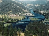
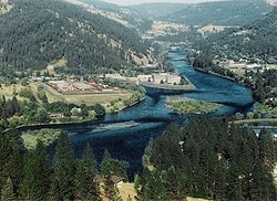
Orofino is a city in Clearwater County
, Idaho
, along Orofino Creek and the north bank of the Clearwater River
. The population was 3,247 at the 2000 census, and the city is the county seat
of Clearwater County
. Nearby is the historical "Canoe Camp," where the Lewis and Clark expedition built five new dugout canoes and embarked on October 7, 1805, downstream to the Pacific Ocean
. Just 4 miles (6.4 km) north of town is the Dworshak National Fish Hatchery
and the Dworshak Dam
, third highest dam in the United States, completed in the early 1970s.
Originally the name was two words, Oro Fino, applied to a gold mining camp established in 1861 two miles (3 km) south of Pierce
, that is now a ghost town
. When the Nez Perce reservation opened to settlers in 1895, Clifford Fuller set up a trading post on his new homestead and the town (Orofino-on-the-Clearwater) was established the next year. The railroad, later part of the Camas Prairie Railroad
, arrived from Lewiston
in 1899.
Orofino is home to both the Idaho Correctional Institution - Orofino and Idaho State Hospital North. These two facilities are located adjacent to another Orofino institution: Orofino High School. The mascot for Orofino High School is the Maniac, one of only two "Maniac" mascots in the country. The town hosts the annual Orofino 4 July Celebration as well as the Clearwater County Fair and Lumberjack Days in late summer. Each spring, the annual Boomershoot
is held nearby.
 According to the United States Census Bureau
, the city has a total area of 6.5 square kilometres (2.5 sq mi). 6.2 km² (2.4 sq mi) of it is land and 0.3 km² (0.115830647577761 sq mi) of it (4.37%) is water.
The climate in the area counts among the hottest in the summer and the mildest in the winter throughout the entire state due to its relatively low elevation and - this is primarily true for the moderate winters - its northwestern location, which places it closer to the Pacific Ocean (more exactly, the Puget Sound) than my other parts of Idaho. Accordingly, Idaho's all time highest temperature of 118 °F (48 °C) was recorded at Orofino on July 28, 1934.
of 2000, there were 3,247 people, 1,137 households, and 767 families residing in the city. The population density
was 1,349.0 people per square mile (520.2/km²). There were 1,279 housing units at an average density of 531.4 per square mile (204.9/km²). The racial makeup of the city was 93.93% White, 0.37% African American, 2.13% Native American, 0.59% Asian, 0.09% Pacific Islander, 0.99% from other races
, and 1.91% from two or more races. Hispanic or Latino of any race were 2.25% of the population.
There were 1,137 households out of which 28.9% had children under the age of 18 living with them, 54.1% were married couples
living together, 8.4% had a female householder with no husband present, and 32.5% were non-families. 27.6% of all households were made up of individuals and 12.8% had someone living alone who was 65 years of age or older. The average household size was 2.33 and the average family size was 2.83.
In the city the population was spread out with 20.1% under the age of 18, 7.9% from 18 to 24, 30.4% from 25 to 44, 26.1% from 45 to 64, and 15.6% who were 65 years of age or older. The median age was 40 years. For every 100 females there were 132.9 males. For every 100 females age 18 and over, there were 143.2 males.
The median income for a household in the city was $30,580, and the median income for a family was $36,908. Males had a median income of $30,386 versus $20,968 for females. The per capita income
for the city was $14,563. About 7.6% of families and 12.1% of the population were below the poverty line, including 16.3% of those under age 18 and 7.1% of those age 65 or over.
operates the Idaho Correctional Institution-Orofino in Orofino.
The United States Postal Service
operates the Orofino Post Office.
, a two-lane undivided highway on the south bank of the Clearwater River, connected to Orofino by a bridge. The highway connects to Lewiston
to the west and Missoula
, Montana
(over Lolo Pass
) to the east. The route is known as the "Northwest Passage Scenic Byway," a National Scenic Byway
.
Clearwater County, Idaho
Clearwater County is a county located in the U.S. state of Idaho. Established in 1911, the county was named after the Clearwater River. As of the 2000 Census the county had a population of 8,930 . The county seat is Orofino....
, Idaho
Idaho
Idaho is a state in the Rocky Mountain area of the United States. The state's largest city and capital is Boise. Residents are called "Idahoans". Idaho was admitted to the Union on July 3, 1890, as the 43rd state....
, along Orofino Creek and the north bank of the Clearwater River
Clearwater River (Idaho)
The Clearwater River is a river in north central Idaho, which flows westward from the Bitterroot Mountains along the Idaho-Montana border, and joins the Snake River at Lewiston. In October 1805, the Lewis and Clark Expedition descended the Clearwater River in dugout canoes, putting in at "Canoe...
. The population was 3,247 at the 2000 census, and the city is the county seat
County seat
A county seat is an administrative center, or seat of government, for a county or civil parish. The term is primarily used in the United States....
of Clearwater County
Clearwater County, Idaho
Clearwater County is a county located in the U.S. state of Idaho. Established in 1911, the county was named after the Clearwater River. As of the 2000 Census the county had a population of 8,930 . The county seat is Orofino....
. Nearby is the historical "Canoe Camp," where the Lewis and Clark expedition built five new dugout canoes and embarked on October 7, 1805, downstream to the Pacific Ocean
Pacific Ocean
The Pacific Ocean is the largest of the Earth's oceanic divisions. It extends from the Arctic in the north to the Southern Ocean in the south, bounded by Asia and Australia in the west, and the Americas in the east.At 165.2 million square kilometres in area, this largest division of the World...
. Just 4 miles (6.4 km) north of town is the Dworshak National Fish Hatchery
Dworshak National Fish Hatchery
Dworshak National Fish Hatchery is a "mitigation" hatchery located on the Clearwater River within the Nez Perce Reservation near Orofino, in north-central Idaho. It was constructed in 1969 by the Army Corps of Engineers, and is presently co-managed by the U.S. Fish and Wildlife Service and the Nez...
and the Dworshak Dam
Dworshak Dam
Dworshak Dam is a hydroelectric, concrete gravity dam in Clearwater County, Idaho, United States on the North Fork Clearwater River. The dam is located northwest of the city of Orofino, and east of Lewiston. The dam is the highest straight-axis concrete dam in the Western Hemisphere and the 22nd...
, third highest dam in the United States, completed in the early 1970s.
Originally the name was two words, Oro Fino, applied to a gold mining camp established in 1861 two miles (3 km) south of Pierce
Pierce, Idaho
Pierce is a city in Clearwater County, Idaho. Elias D. Pierce and Wilbur F. Bassett made the first discovery of gold in Idaho , on Orofino Creek in 1860, a mile north of Pierce....
, that is now a ghost town
Ghost town
A ghost town is an abandoned town or city. A town often becomes a ghost town because the economic activity that supported it has failed, or due to natural or human-caused disasters such as floods, government actions, uncontrolled lawlessness, war, or nuclear disasters...
. When the Nez Perce reservation opened to settlers in 1895, Clifford Fuller set up a trading post on his new homestead and the town (Orofino-on-the-Clearwater) was established the next year. The railroad, later part of the Camas Prairie Railroad
Camas Prairie Railroad
Camas Prairie Railroad Company was a short line railroad in northern Idaho jointly owned and operated by Northern Pacific Railway and Union Pacific Railroad. The Camas Prairie Railroad was known as the "railroad on stilts" due to the many wooden trestles. In one five mile stretch, there were...
, arrived from Lewiston
Lewiston, Idaho
Lewiston is a city in and also the county seat of Nez Perce County in the Pacific Northwest state of Idaho. It is the second-largest city in the northern Idaho region, behind Coeur d'Alene and ninth-largest in the state. Lewiston is the principal city of the Lewiston, ID - Clarkston, WA...
in 1899.
Orofino is home to both the Idaho Correctional Institution - Orofino and Idaho State Hospital North. These two facilities are located adjacent to another Orofino institution: Orofino High School. The mascot for Orofino High School is the Maniac, one of only two "Maniac" mascots in the country. The town hosts the annual Orofino 4 July Celebration as well as the Clearwater County Fair and Lumberjack Days in late summer. Each spring, the annual Boomershoot
Boomershoot
The Boomershoot is a long range precision rifle event held near Orofino, Idaho, each year in late spring. The targets are filled with explosives at ranges from . Shooters are allowed to engage as many targets as they are able during the all-day event...
is held nearby.
Geography
Orofino is located at 46°29′8"N 116°15′32"W (46.485485, -116.258847).United States Census Bureau
The United States Census Bureau is the government agency that is responsible for the United States Census. It also gathers other national demographic and economic data...
, the city has a total area of 6.5 square kilometres (2.5 sq mi). 6.2 km² (2.4 sq mi) of it is land and 0.3 km² (0.115830647577761 sq mi) of it (4.37%) is water.
The climate in the area counts among the hottest in the summer and the mildest in the winter throughout the entire state due to its relatively low elevation and - this is primarily true for the moderate winters - its northwestern location, which places it closer to the Pacific Ocean (more exactly, the Puget Sound) than my other parts of Idaho. Accordingly, Idaho's all time highest temperature of 118 °F (48 °C) was recorded at Orofino on July 28, 1934.
Demographics
As of the censusCensus
A census is the procedure of systematically acquiring and recording information about the members of a given population. It is a regularly occurring and official count of a particular population. The term is used mostly in connection with national population and housing censuses; other common...
of 2000, there were 3,247 people, 1,137 households, and 767 families residing in the city. The population density
Population density
Population density is a measurement of population per unit area or unit volume. It is frequently applied to living organisms, and particularly to humans...
was 1,349.0 people per square mile (520.2/km²). There were 1,279 housing units at an average density of 531.4 per square mile (204.9/km²). The racial makeup of the city was 93.93% White, 0.37% African American, 2.13% Native American, 0.59% Asian, 0.09% Pacific Islander, 0.99% from other races
Race (United States Census)
Race and ethnicity in the United States Census, as defined by the Federal Office of Management and Budget and the United States Census Bureau, are self-identification data items in which residents choose the race or races with which they most closely identify, and indicate whether or not they are...
, and 1.91% from two or more races. Hispanic or Latino of any race were 2.25% of the population.
There were 1,137 households out of which 28.9% had children under the age of 18 living with them, 54.1% were married couples
Marriage
Marriage is a social union or legal contract between people that creates kinship. It is an institution in which interpersonal relationships, usually intimate and sexual, are acknowledged in a variety of ways, depending on the culture or subculture in which it is found...
living together, 8.4% had a female householder with no husband present, and 32.5% were non-families. 27.6% of all households were made up of individuals and 12.8% had someone living alone who was 65 years of age or older. The average household size was 2.33 and the average family size was 2.83.
In the city the population was spread out with 20.1% under the age of 18, 7.9% from 18 to 24, 30.4% from 25 to 44, 26.1% from 45 to 64, and 15.6% who were 65 years of age or older. The median age was 40 years. For every 100 females there were 132.9 males. For every 100 females age 18 and over, there were 143.2 males.
The median income for a household in the city was $30,580, and the median income for a family was $36,908. Males had a median income of $30,386 versus $20,968 for females. The per capita income
Per capita income
Per capita income or income per person is a measure of mean income within an economic aggregate, such as a country or city. It is calculated by taking a measure of all sources of income in the aggregate and dividing it by the total population...
for the city was $14,563. About 7.6% of families and 12.1% of the population were below the poverty line, including 16.3% of those under age 18 and 7.1% of those age 65 or over.
Government and infrastructure
The Idaho Department of CorrectionIdaho Department of Correction
The Idaho Department of Corrections mission is to Protect Idaho through Safety, Accountability, Partnerships and Opportunities for Offender Change. IDOC is responsible for the incarceration and community supervision of felony offenders in Idaho. The department operates eight prisons, five...
operates the Idaho Correctional Institution-Orofino in Orofino.
The United States Postal Service
United States Postal Service
The United States Postal Service is an independent agency of the United States government responsible for providing postal service in the United States...
operates the Orofino Post Office.
Transportation
The city is served by US 12U.S. Route 12 in Idaho
US Route 12 is a state highway in north central Idaho. It extends from the Washington state line in Lewiston east to the Montana state line at Lolo Pass, generally along the route of the Lewis and Clark expedition, and is known as the Northwest Passage Scenic Byway -Route description:US 12 enters...
, a two-lane undivided highway on the south bank of the Clearwater River, connected to Orofino by a bridge. The highway connects to Lewiston
Lewiston, Idaho
Lewiston is a city in and also the county seat of Nez Perce County in the Pacific Northwest state of Idaho. It is the second-largest city in the northern Idaho region, behind Coeur d'Alene and ninth-largest in the state. Lewiston is the principal city of the Lewiston, ID - Clarkston, WA...
to the west and Missoula
Missoula, Montana
Missoula is a city located in western Montana and is the county seat of Missoula County. The 2010 Census put the population of Missoula at 66,788 and the population of Missoula County at 109,299. Missoula is the principal city of the Missoula Metropolitan Area...
, Montana
Montana
Montana is a state in the Western United States. The western third of Montana contains numerous mountain ranges. Smaller, "island ranges" are found in the central third of the state, for a total of 77 named ranges of the Rocky Mountains. This geographical fact is reflected in the state's name,...
(over Lolo Pass
Lolo Pass (Idaho-Montana)
Lolo Pass, elevation , is a mountain pass in the United States, in the Bitterroot Range of the northern Rocky Mountains. It is on the border between the states of Montana and Idaho, approximately west-southwest of Missoula, Montana....
) to the east. The route is known as the "Northwest Passage Scenic Byway," a National Scenic Byway
National Scenic Byway
A National Scenic Byway is a road recognized by the United States Department of Transportation for its archeological, cultural, historic, natural, recreational, and/or scenic qualities. The program was established by Congress in 1991 to preserve and protect the nation's scenic but often...
.