
Clear Fork Mohican River
Encyclopedia
Tributary
A tributary or affluent is a stream or river that flows into a main stem river or a lake. A tributary does not flow directly into a sea or ocean...
of the Mohican River
Mohican River
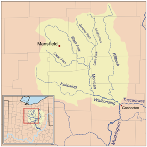
The Mohican River is a principal tributary of the Walhonding River, about 40 miles long, in north-central Ohio in the United States. Via the Walhonding, Muskingum and Ohio Rivers, it is part of the watershed of the Mississippi River, draining an area of 999 square miles .The Mohican River is...
, 36.6 miles (58.9 km) long, in north central Ohio
Ohio
Ohio is a Midwestern state in the United States. The 34th largest state by area in the U.S.,it is the 7th‑most populous with over 11.5 million residents, containing several major American cities and seven metropolitan areas with populations of 500,000 or more.The state's capital is Columbus...
in the United States
United States
The United States of America is a federal constitutional republic comprising fifty states and a federal district...
. Via the Mohican, Walhonding
Walhonding River
The Walhonding River is a principal tributary of the Muskingum River, 23.5 miles long, in east-central Ohio in the United States. Via the Muskingum and Ohio Rivers, it is part of the watershed of the Mississippi River. It drains an area of 2,252 square miles .The Walhonding flows for its entire...
, Muskingum
Muskingum River
The Muskingum River is a tributary of the Ohio River, approximately 111 miles long, in southeastern Ohio in the United States. An important commercial route in the 19th century, it flows generally southward through the eastern hill country of Ohio...
and Ohio
Ohio River
The Ohio River is the largest tributary, by volume, of the Mississippi River. At the confluence, the Ohio is even bigger than the Mississippi and, thus, is hydrologically the main stream of the whole river system, including the Allegheny River further upstream...
Rivers, it is part of the watershed
Drainage basin
A drainage basin is an extent or an area of land where surface water from rain and melting snow or ice converges to a single point, usually the exit of the basin, where the waters join another waterbody, such as a river, lake, reservoir, estuary, wetland, sea, or ocean...
of the Mississippi River
Mississippi River
The Mississippi River is the largest river system in North America. Flowing entirely in the United States, this river rises in western Minnesota and meanders slowly southwards for to the Mississippi River Delta at the Gulf of Mexico. With its many tributaries, the Mississippi's watershed drains...
, draining an area of 219 square miles (567 km²). According to the Geographic Names Information System
Geographic Names Information System
The Geographic Names Information System is a database that contains name and locative information about more than two million physical and cultural features located throughout the United States of America and its territories. It is a type of gazetteer...
, it has also been known historically as "Clear Creek" and as "Clear Fork Mohecan Creek."
The Clear Fork rises in northeastern Morrow County
Morrow County, Ohio
Morrow County is a county located in the state of Ohio, United States. Shawnee people used the area for hunting purposes before white settlers arrived in the early 19th century. Morrow County was organized in 1848 from parts of four neighboring counties and named for Jeremiah Morrow, Governor of...
and flows generally eastwardly through southern Richland
Richland County, Ohio
Richland County is a county located in the state of Ohio, United States. As of the 2010 census, the population was 124,475. It is included in the Mansfield, Ohio, Metropolitan Statistical Area as well as the Mansfield–Bucyrus Combined Statistical Area....
and Ashland
Ashland County, Ohio
Ashland County is a county located in the state of Ohio, United States, and was formed in 1846 from parts of Huron, Lorain, Richland and Wayne Counties. As of the 2010 census, the population was 53,139. Its county seat is Ashland...
Counties, past the towns of Lexington
Lexington, Ohio
Lexington is a village in Richland County in the U.S. state of Ohio. It is part of the Mansfield, Ohio Metropolitan Statistical Area. The population was 4,822 at the 2010 census, an increase from 4,165 in 2000....
, Bellville
Bellville, Ohio
Bellville is a village in Richland County in the U.S. state of Ohio. It is part of the Mansfield, Ohio Metropolitan Statistical Area. The population was 1,773 at the 2000 census.-Geography:...
and Butler
Butler, Ohio
Butler is a village in Richland County in the U.S. state of Ohio. It is part of the Mansfield, Ohio Metropolitan Statistical Area. The population was 921 at the 2000 census.-Geography:...
, and through Mohican State Park
Mohican State Park
Mohican State Park is a Ohio state park in Ashland County, Ohio, United States, located about south of downtown Loudonville, Ohio. The state park is surrounded by the Mohican-Memorial State Forest. Mohican State Park is located along Ohio SR 3 and Ohio SR 97...
. It joins the Black Fork
Black Fork Mohican River
The Black Fork is a principal tributary of the Mohican River, 58.4 miles long, in north-central Ohio in the United States. Via the Mohican, Walhonding, Muskingum and Ohio Rivers, it is part of the watershed of the Mississippi River, draining an area of 351 square miles...
to form the Mohican River in Ashland County, about 2 miles (3 km) southwest of Loudonville
Loudonville, Ohio
Loudonville is a village in Ashland and Holmes counties in the U.S. state of Ohio. The population was 2,906 at the 2000 census. Loudonville is nicknamed the "Canoe Capital of Ohio" for the many canoe liveries along the Mohican River...
.
Upstream of Lexington, a 1949 dam
Dam
A dam is a barrier that impounds water or underground streams. Dams generally serve the primary purpose of retaining water, while other structures such as floodgates or levees are used to manage or prevent water flow into specific land regions. Hydropower and pumped-storage hydroelectricity are...
causes the river to form Clear Fork Reservoir
Clear Fork Reservoir
The Clear Fork Reservoir is a reservoir on the Clear Fork river in the area of Richland County and Morrow County in the U.S. state of Ohio. It was designed and built in 1949 to be the main source of drinking water for the city of Mansfield, Ohio....
, which provides drinking water to the city of Mansfield. In Ashland County, a 1936 U.S. Army Corps of Engineers dam causes the river to form Pleasant Hill Lake.