
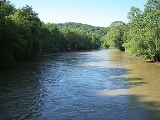
Mohican River
Encyclopedia
Tributary
A tributary or affluent is a stream or river that flows into a main stem river or a lake. A tributary does not flow directly into a sea or ocean...
of the Walhonding River
Walhonding River
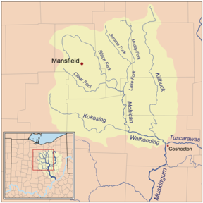
The Walhonding River is a principal tributary of the Muskingum River, 23.5 miles long, in east-central Ohio in the United States. Via the Muskingum and Ohio Rivers, it is part of the watershed of the Mississippi River. It drains an area of 2,252 square miles .The Walhonding flows for its entire...
, about 40 miles (64 km) long, in north-central Ohio
Ohio
Ohio is a Midwestern state in the United States. The 34th largest state by area in the U.S.,it is the 7th‑most populous with over 11.5 million residents, containing several major American cities and seven metropolitan areas with populations of 500,000 or more.The state's capital is Columbus...
in the United States
United States
The United States of America is a federal constitutional republic comprising fifty states and a federal district...
. Via the Walhonding, Muskingum
Muskingum River
The Muskingum River is a tributary of the Ohio River, approximately 111 miles long, in southeastern Ohio in the United States. An important commercial route in the 19th century, it flows generally southward through the eastern hill country of Ohio...
and Ohio
Ohio River
The Ohio River is the largest tributary, by volume, of the Mississippi River. At the confluence, the Ohio is even bigger than the Mississippi and, thus, is hydrologically the main stream of the whole river system, including the Allegheny River further upstream...
Rivers, it is part of the watershed
Drainage basin
A drainage basin is an extent or an area of land where surface water from rain and melting snow or ice converges to a single point, usually the exit of the basin, where the waters join another waterbody, such as a river, lake, reservoir, estuary, wetland, sea, or ocean...
of the Mississippi River
Mississippi River
The Mississippi River is the largest river system in North America. Flowing entirely in the United States, this river rises in western Minnesota and meanders slowly southwards for to the Mississippi River Delta at the Gulf of Mexico. With its many tributaries, the Mississippi's watershed drains...
, draining an area of 999 square miles (2,587 km²).
The Mohican River is formed in Ashland County
Ashland County, Ohio
Ashland County is a county located in the state of Ohio, United States, and was formed in 1846 from parts of Huron, Lorain, Richland and Wayne Counties. As of the 2010 census, the population was 53,139. Its county seat is Ashland...
, about 2 miles (3 km) southwest of Loudonville
Loudonville, Ohio
Loudonville is a village in Ashland and Holmes counties in the U.S. state of Ohio. The population was 2,906 at the 2000 census. Loudonville is nicknamed the "Canoe Capital of Ohio" for the many canoe liveries along the Mohican River...
, by the confluence
Confluence (geography)
In geography, a confluence is the meeting of two or more bodies of water. It usually refers to the point where two streams flow together, merging into a single stream...
of the Black Fork
Black Fork Mohican River
The Black Fork is a principal tributary of the Mohican River, 58.4 miles long, in north-central Ohio in the United States. Via the Mohican, Walhonding, Muskingum and Ohio Rivers, it is part of the watershed of the Mississippi River, draining an area of 351 square miles...
and the Clear Fork
Clear Fork Mohican River
The Clear Fork is a principal tributary of the Mohican River, 36.6 miles long, in north central Ohio in the United States. Via the Mohican, Walhonding, Muskingum and Ohio Rivers, it is part of the watershed of the Mississippi River, draining an area of 219 square miles...
. It then flows generally south-southeast through western Holmes
Holmes County, Ohio
As of the census of 2000, there were 38,943 people, 11,337 households, and 9,194 families residing in the county. The population density was 92 people per square mile . There were 12,280 housing units at an average density of 29 per square mile...
and northeastern Knox
Knox County, Ohio
Knox County is a county located in the state of Ohio, United States. As of 2010, the population was 60,921. Its county seat is Mount Vernon and is named for Henry Knox, an officer in the American Revolutionary War who was later the first Secretary of War....
Counties, past the community of Brinkhaven, into northwestern Coshocton County
Coshocton County, Ohio
Coshocton County is a county located in the state of Ohio, United States. As of the 2010 census, the population was 36,901. Its county seat is Coshocton. Its name comes from the Delaware Indian language and has been translated as "union of waters" or "black bear crossing".The Coshocton...
, where it joins the Kokosing River
Kokosing River
The Kokosing River is a tributary of the Walhonding River, 57.2 miles long, in east-central Ohio in the United States...
to form the Walhonding River. It collects the Lake Fork
Lake Fork Mohican River
The Lake Fork is a tributary of the Mohican River, 14.7 miles long, in north-central Ohio in the United States. Via the Mohican, Walhonding, Muskingum and Ohio Rivers, it is part of the watershed of the Mississippi River, draining an area of 344 square miles .The Lake Fork is formed by the...
in Holmes County.
Near Brinkhaven the river is spanned by the Bridge of Dreams
Bridge of Dreams
The Bridge of Dreams is a 370 foot covered bridge located near Brinkhaven, Ohio. Originally built in the 1920s as a railroad bridge, and covered in 1998. It is the second longest covered bridge in Ohio after the Smolen–Gulf Bridge, and third longest covered bridge in the United States.-History:The...
, the longest covered bridge
Covered bridge
A covered bridge is a bridge with enclosed sides and a roof, often accommodating only a single lane of traffic. Most covered bridges are wooden; some newer ones are concrete or metal with glass sides...
in Ohio
Ohio
Ohio is a Midwestern state in the United States. The 34th largest state by area in the U.S.,it is the 7th‑most populous with over 11.5 million residents, containing several major American cities and seven metropolitan areas with populations of 500,000 or more.The state's capital is Columbus...
.
Variant names and spellings
According to the Geographic Names Information SystemGeographic Names Information System
The Geographic Names Information System is a database that contains name and locative information about more than two million physical and cultural features located throughout the United States of America and its territories. It is a type of gazetteer...
, the Mohican River has also been known historically as:
- Margrets Creek
- Mohecan Creek
- Mohiccan Creek
- Mohiccan John Creek
- Mohiccon Creek
- Mohickan Creek
- Mohickin Johns River