

Cities and towns in West Bengal
Encyclopedia
.jpg)
West Bengal
West Bengal is a state in the eastern region of India and is the nation's fourth-most populous. It is also the seventh-most populous sub-national entity in the world, with over 91 million inhabitants. A major agricultural producer, West Bengal is the sixth-largest contributor to India's GDP...
is the state
States and territories of India
India is a federal union of states comprising twenty-eight states and seven union territories. The states and territories are further subdivided into districts and so on.-List of states and territories:...
with highest population density
Population density
Population density is a measurement of population per unit area or unit volume. It is frequently applied to living organisms, and particularly to humans...
in India
India
India , officially the Republic of India , is a country in South Asia. It is the seventh-largest country by geographical area, the second-most populous country with over 1.2 billion people, and the most populous democracy in the world...
. The state is dotted with several small and medium towns and cities. Historically, the main source of income of the people of West Bengal has been farming, and, as a consequence, the state previously had a large rural population skew. At the turn of the 20th century, however, the role of industry in West Bengal increased substantially, leading to a population move into urban area
Urban area
An urban area is characterized by higher population density and vast human features in comparison to areas surrounding it. Urban areas may be cities, towns or conurbations, but the term is not commonly extended to rural settlements such as villages and hamlets.Urban areas are created and further...
s.
In 1947, when India gained independence, the erstwhile British Indian province of Bengal
Bengal
Bengal is a historical and geographical region in the northeast region of the Indian Subcontinent at the apex of the Bay of Bengal. Today, it is mainly divided between the sovereign land of People's Republic of Bangladesh and the Indian state of West Bengal, although some regions of the previous...
was divided into two parts: the eastern region formed East Pakistan
East Pakistan
East Pakistan was a provincial state of Pakistan established in 14 August 1947. The provincial state existed until its declaration of independence on 26 March 1971 as the independent nation of Bangladesh. Pakistan recognized the new nation on 16 December 1971. East Pakistan was created from Bengal...
-- which became Bangladesh
Bangladesh
Bangladesh , officially the People's Republic of Bangladesh is a sovereign state located in South Asia. It is bordered by India on all sides except for a small border with Burma to the far southeast and by the Bay of Bengal to the south...
in 1971 — and the western part joined India as the state of West Bengal. Scores of refugees from the eastern part came to West Bengal, leading to the start of new urban areas, and contributing to the congestion of already established cities like Kolkata.
Classification
India censusCensus
A census is the procedure of systematically acquiring and recording information about the members of a given population. It is a regularly occurring and official count of a particular population. The term is used mostly in connection with national population and housing censuses; other common...
, 375 cities and towns in West Bengal can be classified in the following categories:
- 2 Urban agglomeration (UA): KolkataKolkataKolkata , formerly known as Calcutta, is the capital of the Indian state of West Bengal. Located on the east bank of the Hooghly River, it was the commercial capital of East India...
, Kolkata Municipal CorporationKolkata Municipal CorporationKolkata Municipal Corporation is responsible for the civic infrastructure and administration of the city of Kolkata. The organization is known, in short, as KMC . This civic administrative body administers an area of 185 sq. km. Its motto, Purosree Bibardhan, is inscribed on its emblem in Bengali...
is responsible for civic administration of the city, whereas Kolkata Metropolitan Development AuthorityKolkata Metropolitan Development AuthorityKolkata Metropolitan Development Authority is the statutory planning and development authority for the Kolkata Metropolitan Area in the state of West Bengal, India. The organisation was previously known as Calcutta Metropolitan Development Authority and still retains the previous logo...
is responsible for Greater Kolkata, the UA.SiliguriSiliguriSiliguri is a city in the Indian state of West Bengal. It is located in the Siliguri Corridor or Chicken's Neck - a very narrow strip of land linking mainland India to its north-eastern states. It is also the transit point for air, road and rail traffic to the neighbouring countries of Nepal,...
, AsansolAsansolAsansol is a coal mining and industrial metropolis and one of the busiest commercial centres in India. It is the second largest city and urban agglomeration in West Bengal after Kolkata and the 19th largest urban agglomeration in India. Asansol is located in the western part of the Burdwan...
, Durgapur forms the other UA. - 6 Municipal CorporationMunicipal corporationA municipal corporation is the legal term for a local governing body, including cities, counties, towns, townships, charter townships, villages, and boroughs. Municipal incorporation occurs when such municipalities become self-governing entities under the laws of the state or province in which...
s: Kolkata, Asansol, ChandannagarChandannagarChandannagar, formerly known as Chandernagore or Chandernagar , is a small city and former French colony located north of Kolkata, in West Bengal, India. It is head quarters of a subdivision in Hooghly District. It is one of the 6 municipal corporations in West Bengal. It is a part of the area...
, Durgapur, Howrah and SiliguriSiliguriSiliguri is a city in the Indian state of West Bengal. It is located in the Siliguri Corridor or Chicken's Neck - a very narrow strip of land linking mainland India to its north-eastern states. It is also the transit point for air, road and rail traffic to the neighbouring countries of Nepal,...
. - 114 Municipalities: AlipurduarAlipurduarAlipurduar is a sub-divisional municipal city of Jalpaiguri district, and is located at the eastern end of the district. Situated on the east bank of Kaljani River on the foothills of the Himalayas, the town is a gateway to Bhutan and North Eastern states of India...
, ArambagArambagArambag is a town and a municipality in Hooghly district in the state of West Bengal, India. It is the head quarter of Arambagh subdivision.-Geography:...
, Ashoknagar KalyangarhAshoknagar KalyangarhAshoknagar Kalyangarh is a popular city and a municipality under Ashoknagar police station of Barasat sadar subdivision in North 24 Parganas district in the state of West Bengal, India....
, BaduriaBaduriaBaduria is a town and a municipality and police station of Basirhat subdivision in North 24 Parganas district in the state of West Bengal, India.-Geography:Baduria is located at . It has an average elevation of 8 metres .-Demographics:...
, BaharampurBaharampurBaharampur is a city in the West Bengal state of India. Baharampur is the sixth largest city in West Bengal and situated in central part of West Bengal. Baharampur is nominated for becoming the municipal corporation...
, BaidyabatiBaidyabatiBaidyabati is a city and a municipality in Hooghly district in the state of West Bengal, India. It is under Serampore police station in Srirampore subdivision. Now it is a part of the area covered by Kolkata Metropolitan Development Authority.-Geography:...
, BallyBally, HowrahBally is a city, municipality in Howrah District, West Bengal, India. It is a part of the area covered by Kolkata Metropolitan Development Authority. It is a town of historical importance...
, BalurghatBalurghatBalurghat is the headquarters of the Dakshin Dinajpur district of West Bengal in India. Hili Balurghat is the headquarters of the Dakshin Dinajpur district of West Bengal in India. Hili Balurghat is the headquarters of the Dakshin Dinajpur district of West Bengal in India. Hili (Bangladesh...
, BangaonBangaonBongaon is a city and a municipality in North 24 Parganas district in the state of West Bengal, India. Bongaon is headquarters of Bongaon subdivision.- Geography :...
, BankuraBankuraBankura is a city and a municipality in Bankura District in the state of West Bengal, India. It is the headquarters of the Bankura District.-Etymology:...
, BansberiaBansberiaBansberia is a town and a municipality in Hooghly district in the state of West Bengal, India. It is under Mogra/ Chinsurah police stations in Chinsurah subdivision. It is at the western end of the Kalyani Bridge, and a part of the area covered by Kolkata Metropolitan Development Authority...
, BaranagarBaranagarBaranagar or Barahanagar, meaning the big and town or land of the pig , is a town in the northern outskirts of Kolkata. It is a municipality in North 24 Parganas district in the state of West Bengal, India. A railway station of the same name is on the Dankuni line off the Sealdah north section...
, BarasatBarasatBarasat is a city in the outskirts of Kolkata, West Bengal India and is the district head quarter of the district North 24 Parganas. It is a part of the area covered by Kolkata Metropolitan Development Authority. The town is an important railway and roadway junction...
, Barddhaman, Barrackpur, BaruipurBaruipurBaruipur is a city and a municipality in South 24 Parganas district in the state of West Bengal, India. Baruipur is 25 km from Sealdah Station.-Geography:Baruipur is located at . It has an average elevation of 9 metres ....
, BasirhatBasirhatBasirhat is a city and a municipality in North 24 Parganas district in the state of West Bengal, India. Basirhat subdivisional town is located on the banks of Ichamati River.- History :...
, BeldangaBeldangaBeldanga is a town and a municipality in Murshidabad district in the state of West Bengal, India.-Geography:Beldanga is located at . It has an average elevation of 20 metres .-Demographics:...
, Bhadreswar, BhatparaBhatparaBhatpara is a city and a municipality under Jagatdal police station of Barrackpore subdivision in North 24 Parganas district in the state of West Bengal, India. It is situated on the bank of Hoogly river. It is mainly known for its rich traditions in the field of Sanskrit learning...
, Bidhan Nagar, BirnagarBirnagarBirnagar is a city and a municipality under Taherpur police station of Ranaghat subdivision in Nadia district in the state of West Bengal, India.-History:...
, Bishnupur, BolpurBolpurBolpur-Santiniketan is a municipality in Birbhum District in the state of West Bengal, India. It is 145 km north of Kolkata and is best known for the proximity to Visva Bharati, the university set up by Rabindranath Tagore the Nobel laureate poet...
, Budge Budge, Cannin, ChakdahaChakdahaChakdaha is a city and a municipality in Kalyani subdivision of Nadia district in the state of West Bengal, India.-Geography:Chakdaha is located at . It has an average elevation of 11 metres...
, ChampdaniChampdaniChampdani is a town and a municipality in Hooghly district in the state of West Bengal, India. It is under Bhadreswar police station in Chandannagar subdivision.-Geography:...
, ChandrakonaChandrakonaChandrakona is a town with a municipality in the Ghatal subdivision of Paschim Medinipur district in the state of West Bengal, India. It is a small town. This town is located between Ghatal and Garhbeta. The king – Chandraketu was the founder of the kingdom of Chandrakona. In Ain-E-Akbari it was...
, ContaiContaiContai is head quarters of Contai subdivision in Purba Medinipur district, West Bengal, India. There are three community development blocks in Contai.- History :...
, DainhatDainhatDainhat is a Town and a municipality under Katwa police station and Katwa subdivision, in Bardhaman district in the state of West Bengal, India.-Demographics:...
, Darjiling, DhulianDhulianDhulian is a city and a municipality in Murshidabad district in the state of West Bengal, India. It is located between the Ganges and the Hooghly canal....
, Diamond HarbourDiamond HarbourDiamond Harbour is in the southern suburbs of Kolkata, on the banks of the Hooghly River quite near where the river meets the Bay of Bengal. This small town is a popular weekend tourist spot located in South 24 Parganas district....
, DinhataDinhataDinhata is head quarterss of Dinhata subdivision, and a municipality in Cooch Behar District in the state of West Bengal, India.-Geography:Dinhata is located at . It has an average elevation of 36 metres .-Demographics:...
, DubrajpurDubrajpurDubrajpur is a town and a municipality in Suri Sadar subdivision of Birbhum District in the Indian state of West Bengal.-Geography:Dubrajpur is located at . It has an average elevation of 77 metres .-Demographics:...
, DumdumDum DumDum Dum is a city and a municipality in North 24 Parganas district in the state of West Bengal, India. It is a neighbourhood in North-west Kolkata and the location of Netaji Subhash Chandra Bose International Airport, formerly Dum Dum Airport.Dum Dum is a well known place in greater Kolkata...
, EgraEgraEgra is head quarters of Egra subdivision in Purba Medinipur district in the state of West Bengal, India. it is a town with a municipality and community development blocks.-Geography:...
, English BazarEnglish BazarEnglish Bazar, better known as Malda, called mango city, is a city and a municipality in Malda district in the state of West Bengal, India. Malda is the fifth largest city in West Bengal. Malda is nominated for becoming the municipal corporation...
, FalakataFalakataFalakata is a census town and police station of Alipurduar subdivision in Jalpaiguri district in the state of West Bengal, India.-Geography:...
, GangarampurGangarampurGangarampur is a town and a municipality in Dakshin Dinajpur district in the state of West Bengal, India.-Geography:Gangarampur is located at . It has an average elevation of 25 metres .-Demographics:...
, GaruliaGaruliaGarulia is a town and a municipality under Noapara police stations of Barrackpore subdivision in North 24 Parganas district in the state of West Bengal, India. It is a part of the area covered by Kolkata Metropolitan Development Authority. Garulia Municipality is sub-divided into 12 wards for the...
, GayespurGayespurGayespur is a town and a municipality under Kalyani police station of Kalyani subdivision in Nadia district in the Indian state of West Bengal.-Geography:...
, GhatalGhatalGhatal is head quarters of Ghatal subdivision in Paschim Medinipur district, West Bengal, India. It also has a community development block. Ghatal is flood-prone area and in many years is flooded by the Rupnarayan River. This town is old one. The river Shilabati divided the town into two parts....
, GobardangaGobardangaGobardanga is a town and a municipality under Habra police station of Barasat sadar subdivision in North 24 Parganas district in the Indian state of West Bengal. It is one of the oldest municipality of West Bengal. Go means 'world/earth', Bar means 'Greatest' and Danga means 'Place'. i.e...
, GuskaraGuskaraGuskara is a town and a municipality under Ausgram police station of Sadar subdivision in Barddhaman district in the Indian state of West Bengal.-Geography:Guskara is located at . It has an average elevation of 38 metres ....
, HabraHabraHabra is a city, a municipality and a police station of Barasat sadar subdivision in North 24 Parganas district in the Indian state of West Bengal. It is an administrative subdivision. Habra is situated on the Jessore Road between Kolkata and the Bangladesh border at Petrapole...
, HaldiaHaldiaHaldia has a typical moderate climate with winter temperatures ranging from a low of around 7 degrees Celsius to a high of 22 degrees Celsius. Winters are chilly and is when the residents hold the Haldia Utsav festival. Summers can be very hot and humid. Usual summer temperatures in May, the...
, Haldibari, HalisaharHalisaharHalisahar is a city and a municipality under Bijpur/ Naihati police stations of Barrackpore subdivision. in North 24 Parganas district in the Indian state of West Bengal. It is a part of the area covered by Kolkata Metropolitan Development Authority.It was formerly known Kumarhata. It has an...
, Hugli-Chinsurah, Islampur, JalpaiguriJalpaiguriJalpaiguri is a city in the state of West Bengal, India. It is the headquarters of Jalpaiguri district, and the divisional headquarters of the North Bengal region.-History:...
, JamuriaJamuriaJamuria is a city and a municipality in Asansol subdivision of Barddhaman district in the Indian state of West Bengal.-Geography:Jamuria is located at . It has an average elevation of 111 metres ....
, Jangipur, Jaynagar MazilpurJaynagar MazilpurJaynagar Majilpur is a town and a municipality in South 24 Parganas district in the Indian state of West Bengal. It is a part of the area covered by Kolkata Metropolitan Development Authority. Both the places are also identified separately a Jaynagar and Majilpur...
, JhaldaJhalda'Jhalda is a city and a municipality in Purulia District in the Indian state of West Bengal. GeographyJhalda is located at . It has an average elevation of ....
, JhargramJhargramJhargram is a subdivisional municipality in the Paschim Medinipur district in the Indian state of West Bengal.Beyond the Gangetic plains of West Bengal,INDIA...
, Jiaganj Azimganj, KaliaganjKaliaganjKaliaganj is a city and a municipality in Uttar Dinajpur district in the Indian state of West Bengal.-Demographics: India census, Kaliaganj had a population of 47,639. Males constitute 52% of the population and females 48%. Kaliaganj has an average literacy rate of 70%, higher than the national...
, Kalimpong, Kalna, KalyaniKalyani, West BengalKalyani is a city and a municipality in Nadia district in the Indian state of West Bengal. It is a part of the area covered by Kolkata Metropolitan Development Authority....
, KamarhatiKamarhatiKamarhati is a city and a municipality under Belghoria police station of Barrackpore subdivision. in North 24 Parganas district in the Indian state of West Bengal...
, KanchraparaKanchraparaKanchrapara is a city and a municipality under Bijpur police station of Barrackpore subdivision. in North 24 Parganas district in the Indian state of West Bengal. It is a part of the area covered by Kolkata Metropolitan Development Authority.-Geography:...
, KandiKandi, MurshidabadKandi is a town and a municipality in Murshidabad district in the Indian state of West Bengal. It is headquarters of Kandi subdivision.-Geography:Kandi is located at...
, KatwaKatwaKatwa is the head quarters of Katwa subdivision in the district of Bardhaman, West Bengal. The area has a rural charm and natural beauty, but many trading and other business activities has made it clumsy and congested. It is mostly a middle class residential area.-History:The small town has a five...
, Kharagpur, KhararKharar, GhatalKharar is a municipality in Paschim Medinipur district in the Indian state of West Bengal.Iswar Chandra Vidyasagar was born in Birsingh -Kharar.-History:...
, KhardahaKhardahaKhardaha is a city, a municipality and police station of Barrackpore subdivision in North 24 Parganas district in the Indian state of West Bengal. It is a part of the area covered by Kolkata Metropolitan Development Authority....
, Koch BiharCooch BeharCooch Behar is the district headquarters and the largest city of Cooch Behar District in the Indian state of West Bengal. It is situated in the foothills of the Eastern Himalayas and located at . Cooch Behar is the only planned town in North Bengal region with remnants of royal heritage...
, KonnagarKonnagarKonnagar is a city and a municipality in Hooghly District in the Indian state of West Bengal. There are 20 wards in the Konnagar Municipal Area. It is under Uttarpara police station in Serampore subdivision. It is a part of the area covered by Kolkata Metropolitan Development Authority...
, Krishnanagar, KshirpaiKshirpaiKhirpai also known as Kshirpai, is a town and a municipality in West Midnapore in the Indian state of West Bengal. The town is situated near the banks of river Shilabati and Kethai. The municipality is one of the oldest municipality in India. Location of the municipality is between Ghatal and...
, KultiKultiKulti is a city and a municipality in Bardhaman district in the Indian state of West Bengal.-Geography:Kulti is located at latitude 23°43'60N and longitude 86°50'60E at an elevation of 114 meters. The Asansol-Durgapur region is composed of undulating latterite soil. This area lies between two...
, KurseongKurseongKurseong is a hill station situated in Darjeeling district of West Bengal, India.Located at an altitude of 1458 metres , Kurseong is just 30 km from Darjeeling...
, MadhyamgramMadhyamgramMadhyamgram is a small town in the district of North 24 Parganas within the Indian state of West Bengal and suburban of Metropolitan City Kolkata, having Calcutta postal code and telephone zone...
, MaheshtalaMaheshtalaMaheshtala is a city and a municipality under Maheshtala, Thakurpukur, Metiaburuz and Behala police stations of Alipore sadar subdivision in South 24 Parganas district in the Indian state of West Bengal.-Demographics:...
, MalMalbazarMalbazar , also known as Mal, is a sub-divisional town, a municipality in Jalpaiguri district, located in North Bengal, India. It lies about 65 km from Jalpaiguri and 55 km from Siliguri.-History:...
, MathabhangaMathabhangaMathabhanga is a city and a municipality in Koch Bihar district in the Indian state of West Bengal.-Geography:Mathabhanga is located at . It has an average elevation of .-Demographics:...
, Medinipur, MekliganjMekliganjMekliganj is a city and a municipality in Koch Bihar district in the Indian state of West Bengal.-Geography:Mekliganj is located at . It has an average elevation of .-Demographics:...
, MemariMemariMemari is a town and a municipality in the Bardhaman Sadar South subdivision of Bardhaman district in the Indian state of West Bengal.-Geography:Memari is located at...
, MirikMirikMirik is a picturesque tourist spot nestled in the serene hills of Darjeeling district in West Bengal, India. The name Mirik comes from the Lepcha words Mir-Yok meaning "place burnt by fire"....
, MurshidabadMurshidabadMurshidabad is a city in Murshidabad district of West Bengal state in India. The city of Murshidabad is located on the southern bank of the Bhagirathi, a distributary of the Ganges River. It was the capital of undivided Bengal during the Mughal rule. Nawabs of Bengal used to rule Bengal from this...
, NabadwipNabadwipNabadwip is a city and a municipality in Nadia district in the Indian state of West Bengal. Its name means "9 islands" in the Bengali language. The islands are named Antardwip , Simantadwip, Rudradwip, Madhyadwip, Godrumdwip, Ritudwip, Jahnudwip, Modadrumdwip, and Koladwip...
, NaihatiNaihatiNaihati is a town and an important railway junction station on the Indian Railways network, in the district of North 24 Parganas, West Bengal, India.-Geography:Naihati is located at...
, New BarrackpurNew BarrackpurNew Barrackpur is a town and a municipality under Ghola police station of Barrackpore subdivision. in North 24 Parganas district in the Indian state of West Bengal.-Geography:...
, North BarrackpurNorth BarrackpurNorth Barrackpur is a city and a municipality under Barrackpore/ Noapara police stations of Barrackpore subdivision in North 24 Parganas district in the Indian state of West Bengal.-Geography:North Barrackpur is located at .-Demographics:...
, North DumdumNorth DumdumNorth Dumdum is a city and a municipality in North 24 Parganas district in the Indian state of West Bengal.-Geography:North Dum Dum is located at .-Demographics:...
, Old MaldahOld MaldahOld Maldah is a municipality in Malda district in the Indian state of West Bengal.-Demographics: India census, Old Maldah had a population of 62,944. Males constitute 52% of the population and females 48%. Old Maldah has an average literacy rate of 61%, higher than the national average of 59.5%:...
, PanihatiPanihatiPanihati is a city and a municipality under Khardaha/ Ghola police stations of Barrackpore subdivision. in North 24 Parganas district in the Indian state of West Bengal. It is a part of the area covered by Kolkata Metropolitan Development Authority....
, PujaliPujaliPujali is a town and a municipality under Budge Budge police station of Alipore sadar subdivision in South 24 Parganas district in the Indian state of West Bengal. It is a part of the area covered by Kolkata Metropolitan Development Authority.-Geography:...
, Puruliya, RaghunathpurRaghunathpur, PuruliaRaghunathpur is a subdivisional town in Purulia district of West Bengal, India. It is on the Purulia – Barakar road.-Geography:Raghunathpur is located at . It has an average elevation of . The area forms the lowest step of the Chota Nagpur Plateau. The general scenario is undulating land with...
, RaiganjRaiganjRaiganj is a city and a municipality in Uttar Dinajpur district in the Indian state of West Bengal. It is the headquarters of a district as well as a subdivision.-Geography:...
, Rajarhat Gopalpur, Rajpur SonarpurRajpur SonarpurRajpur Sonarpur is a city and a municipality under Sonarpur police station of Baruipur subdivision in South 24 Parganas district in the Indian state of West Bengal...
, RamjibanpurRamjibanpurRamjibanpur is a town and a municipality in Paschim Medinipur district in the Indian state of West Bengal.-Geography:Ramjibanpur is located at . It has an average elevation of 11 metres .-Demographics:...
, RampurhatRampurhatRampurhat is a city and a municipality in Birbhum District in the Indian state of West Bengal. It is a small and peaceful town near the West Bengal / Jharkhand border...
, RanaghatRanaghatRanaghat is a city in the district of Nadia, West Bengal, India. It is situated 74 kilometres north of Calcutta. It is known for its handloom industry, various types of flowers and sweet dishes. The town has spread up along its borders in all corners recently. People from the nearby places do come...
, RaniganjRaniganjRaniganj is a city and a municipality in Bardhaman district in the Indian state of West Bengal.-Geography:Raniganj is located at . It has an average elevation of 91 metres ....
, RishraRishraRishra is an Tier Two Industrial Town and has a municipality in Hooghly district in the Indian state of West Bengal. It is a part of the area covered by Kolkata Metropolitan Development Authority.-Geography:...
, SainthiaSainthiaSainthia is a town and a municipality in Suri Sadar subdivision of Birbhum district in the Indian state of West Bengal. The town is famous for Nandikeshwari Temple, one of the Shakti Peethas in India.-Geography:...
, Santipur, SeramporeSeramporeSerampore is a city and a municipality in Hooghly district in the Indian state of West Bengal. It is a part of the area covered by Kolkata Metropolitan Development Authority. It is a pre-colonial town on the right bank of the Hoogli River...
, SonamukhiSonamukhiSonamukhi is a town and a municipality in Bankura District in the Indian state of West Bengal.-Geography:Sonamukhi is located at . It has an average elevation of 66 metres .-Demographics:...
, South DumdumSouth DumdumSouth Dumdum is a city and a municipality in North 24 Parganas district in the Indian state of West Bengal. South Dum Dum consists of localities like, Nagerbazar, Bangur, Dum Dum Park, Lake Town, Paikpara.-Demographics:...
, Suri, TakiTaki (India)Taki is a town and a municipality under Hasnabad police station of Basirhat subdivision in North 24 Parganas district in the Indian state of West Bengal.-Geography:Taki is located at . It has an average elevation of 5 metres .-Culture:...
, TamlukTamlukTamluk is the district headquarters of Purba Medinipur district of West Bengal, India. Though there is some controversy, scholars have generally agreed that present day Tamluk is the site of the ancient city variously known as Tamralipta or Tamralipti...
, TarakeswarTarakeswarTarakeswar is a town and a municipality in Hooghly District in the Indian state of West Bengal. It is a police station in Chandannagar subdivision. Tarakeswar is a renowned place of pilgrimage and the greatest centre of the Shiva sect in West Bengal. 58 km away from Kolkata, Tarakeswar can be...
, TitagarhTitagarhTitagarh is a city and a municipality in North 24 Parganas district in the Indian state of West Bengal. It is a part of the area covered by Kolkata Metropolitan Development Authority.-Geography:...
, TufanganjTufanganjTufanganj is a sub-division town and a municipality in Cooch Behar district in the Indian state of West Bengal.Unofficial Website:http://tufanganj.50webs.com-Geography:...
, UluberiaUluberiaUluberia is a city and a municipality in Howrah district in the Indian state of West Bengal. It is a part of the area covered by Kolkata Metropolitan Development Authority.-Geography:...
and Uttarpara Kotrung. - 2 notified areaNotified areaIn urban planning, a notified area is any land area earmarked by legal provision for future development. The term is used in the Hindi belt region of North India....
: Cooper's CampCooper's CampCooper's Camp is a city and a notified area in Nadia district under Ranaghat police station of Ranaghat subdivision in the state of West Bengal, India.-Geography:...
and TaherpurTaherpurTaherpur is a city and a notified area under Taherpur police station at TAHERPUR Nadia district in the Indian state of West Bengal.-Geography:... - 1 cantonmentCantonmentA cantonment is a temporary or semi-permanent military or police quarters. The word cantonment is derived from the French word canton meaning corner or district, as is the name of the Cantons of Switzerland. In South Asia, the term cantonment also describes permanent military stations...
: Barrackpur CantonmentBarrackpur CantonmentBarrackpur Cantonment is a cantonment town under Barrackpore subdivisionin North 24 Parganas district in the state of West Bengal, India.-Demographics:...
and - 252 census towns.
Now, number of municipalities has been increased to 117 as four new municipalities have been established: Nalhati
Nalhati
Nalhati is a town, municipality in Birbhum District in the Indian state of West Bengal near the West Bengal / Jharkhand border. This town is named after the Shakti peetha Nalhateshwari temple, which according to the mythologies is the situated where the "nala" i.e. throat of goddess Shakti had...
(2000), Dhupguri
Dhupguri
Dhupguri is a town, municipality in Jalpaiguri district in the state of West Bengal, India. It is one of the main business centre of Dooars area. Dhupguri municipality was established in 2001.-Geography:Dhupguri is located at...
(2001), Panskura
Panskura
Panskura is a town, municipality and a Police station in Purba Medinipur in the Indian state of West Bengal.-Geography:Panskura is located at . It has an average elevation of 7 metres . Its a situated on the NH6 on the way from Kolkata to Kharagpur.-Economy:The livelihood of the common people...
(2001) and Dalkhola
Dalkhola
Dalkhola is a municipality located in the Uttar Dinajpur district of the state of West Bengal, India.-History:Dalkhola was originally in the state of Bihar in India. After 1959, Dalkhola was located in the state of West Bengal...
(2003). So, the number of census towns is now reduced to 250 as Dhupguri and Dalkhola have been upgraded to municipality.
Major cities
| Name | Coordinates | Area | Status | Population Density Population density Population density is a measurement of population per unit area or unit volume. It is frequently applied to living organisms, and particularly to humans... |
Importance | |
|---|---|---|---|---|---|---|
| Kolkata Kolkata Kolkata , formerly known as Calcutta, is the capital of the Indian state of West Bengal. Located on the east bank of the Hooghly River, it was the commercial capital of East India... |
22.57°N 88.37°E | 187.5 km² (72.4 sq mi) | Municipal Corporation | 4580544 | 24430 /km2 | The capital of West Bengal West Bengal West Bengal is a state in the eastern region of India and is the nation's fourth-most populous. It is also the seventh-most populous sub-national entity in the world, with over 91 million inhabitants. A major agricultural producer, West Bengal is the sixth-largest contributor to India's GDP... . It was the capital of the of British India until 1911. Kolkata is one of the four big cities in India, and is one of the largest urban agglomerations in the world. |
| Howrah Howrah, India Howrah or Haora is an industrial city, a municipal corporation in the Howrah district, West Bengal, India. It is the headquarters of the district, and also the headquarters of Howrah Sadar subdivision of the district. Located on the west bank of the Hoogli River, it is a twin city of Kolkata.... |
22.59°N 88.31°E | 51.74 km² (20 sq mi) | Municipal Corporation | 1008704 | 19496 /km2 | A primarily industrial city, and the second largest city in West Bengal. It is located on the west bank of the Hooghly River, and is the twin city to Kolkata Kolkata Kolkata , formerly known as Calcutta, is the capital of the Indian state of West Bengal. Located on the east bank of the Hooghly River, it was the commercial capital of East India... . Headquarters of the Howrah district Howrah District Howrah district is a district of the West Bengal state in eastern India. It has thousands of years of rich heritage in the form of the great Bengali kingdom of Bhurshut. The district is named after its headquarters, the city of Howrah.-Geography:... . |
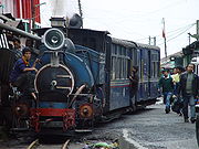
| Darjeeling | 27.03°N 88.16°E | 10.57 km² (4.1 sq mi) | Municipality | 107530 | 10173 /km2 | It is a famous hill station Hill station A hill station is a town located at a higher elevation than the nearby plain or valley. The term was used mostly in colonial Asia , but also in Africa , for towns founded by European colonial rulers as refuges from the summer heat, up where temperatures are cooler... and tourist destination. It is also known for its access route, the Darjeeling Himalayan Railway Darjeeling Himalayan Railway The Darjeeling Himalayan Railway, nicknamed the "Toy Train", is a narrow gauge railway from New Jalpaiguri to Darjeeling in West Bengal, run by the Indian Railways.... , Darjeeling tea Darjeeling tea Darjeeling tea is a black tea from the Darjeeling region in West Bengal, India. When properly brewed, it yields a thin-bodied, light-colored infusion with a floral aroma... , and historical role of the city as a summer retreat. Headquarters of the Darjeeling district Darjeeling district Darjeeling District is the northernmost district of the state of West Bengal in eastern India in the foothills of the Himalayas. The district is famous for its beautiful hill stations and Darjeeling tea. Darjeeling is the district headquarters... . |
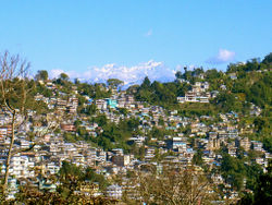
| Kalimpong | 27.06°N 88.47°E | 8.67 km² (3.3 sq mi) | Municipality | 42980 | 4957 /km2 | It is a hill station in the Darjeeling district Darjeeling district Darjeeling District is the northernmost district of the state of West Bengal in eastern India in the foothills of the Himalayas. The district is famous for its beautiful hill stations and Darjeeling tea. Darjeeling is the district headquarters... . It is known as a tourist destination, especially for its climate, and for its Buddhist monasteries and flower market. |
| Kharagpur | 22.33°N 87.33°E | 90.65 km² (35 sq mi) | Municipality | 207984 | 2294 /km2 | The fifth largest city of West Bengal (by area) is famous for the Indian Institute of Technology. Also has the longest railway platform in the world in its railway station, and a major air force base nearby. |
| Bardhaman Bardhaman 'Bardhaman or Burdwan , is a city of West Bengal state in eastern India. It is the headquarters of Bardhaman District.... |
23.25°N 87.85°E | 48 km² (18.5 sq mi) | Municipality | 285871 | 5956 /km2 | Headquarters of the Bardhaman district Bardhaman District 'Bardhaman district is a district in West Bengal. The headquarter of the district is Bardhaman, though it houses other important industrial towns like Durgapur and Asansol... . |
| Asansol Asansol Asansol is a coal mining and industrial metropolis and one of the busiest commercial centres in India. It is the second largest city and urban agglomeration in West Bengal after Kolkata and the 19th largest urban agglomeration in India. Asansol is located in the western part of the Burdwan... |
23.68°N 86.98°E | 127.24 km² (49.1 sq mi) | Municipal Corporation | 486304 | 3822 /km2 | An industrial town in the Bardhaman District. It is known for its famous iron and steel works and the locomotive works at Chittaranjan Chittranjan Locomotive Works Chittranjan Locomotive Works is an electric locomotive manufacturer based in India, one of the largest manufacturers in the world.- Overview :... . It is the third largest city of West Bengal. |
| Durgapur | 23.48°N 87.32°E | 154.2 km² (59.5 sq mi) | Municipal Corporation | 492996 | 3197 /km2 | An industrial town in the Bardhaman District, famous for the National Institute of Technology, Durgapur National Institute of Technology, Durgapur The National Institute of Technology, Durgapur , formerly the Regional Engineering College , Durgapur, was established under an Act of the Parliament of India in 1960 as one of the eight RECs... and the Central Mechanical Engineering Research Institute Central Mechanical Engineering Research Institute Central Mechanical Engineering Research InstituteCMERI is an engineering research institute based in Durgapur, West Bengal, India. It was established in February 1958 with the specific task of development of mechanical engineering technology and is funded by the Council of Scientific and Industrial... the commercial capital of the Rarh region Rarh region Rarh region of West Bengal is the region that lies between the Western plateau and high lands and the Ganges Delta... , a large industrial city with well-planned roads and townships. The fourth largest city in West Bengal. |
| Murshidabad Murshidabad Murshidabad is a city in Murshidabad district of West Bengal state in India. The city of Murshidabad is located on the southern bank of the Bhagirathi, a distributary of the Ganges River. It was the capital of undivided Bengal during the Mughal rule. Nawabs of Bengal used to rule Bengal from this... |
24.18°N 88.27°E | 12.95 km² (5 sq mi) | Municipality | 160168 | 12368 /km2 | It was the capital of Bengal Bengal Bengal is a historical and geographical region in the northeast region of the Indian Subcontinent at the apex of the Bay of Bengal. Today, it is mainly divided between the sovereign land of People's Republic of Bangladesh and the Indian state of West Bengal, although some regions of the previous... before British Raj British Raj British Raj was the British rule in the Indian subcontinent between 1858 and 1947; The term can also refer to the period of dominion... . |
| Malda English Bazar English Bazar, better known as Malda, called mango city, is a city and a municipality in Malda district in the state of West Bengal, India. Malda is the fifth largest city in West Bengal. Malda is nominated for becoming the municipal corporation... |
25.00°N 88.15°E | 13.25 km² (5.1 sq mi) | Municipality | 161448 | 12185 /km2 | It was the capital of Bengal from 5th century BC till the time of Muslim rule. The relics are at Gaur Gaur, West Bengal Gour, or Gaur , as it is spelt mostly in modern times, or Lakhnauti is a ruined city, in the Malda district of West Bengal, India, on the west bank of the Ganges river, 40 kilometers downstream from Rajmahal.-History:... and Pandua. |
| Siliguri Siliguri Siliguri is a city in the Indian state of West Bengal. It is located in the Siliguri Corridor or Chicken's Neck - a very narrow strip of land linking mainland India to its north-eastern states. It is also the transit point for air, road and rail traffic to the neighbouring countries of Nepal,... |
26.71°N 88.43°E | 41.9 km² (16.2 sq mi) | Municipal Corporation | 470275 | 11224 /km2 | An arterial city in North Bengal North Bengal North Bengal is a term used for the northern parts of Bangladesh and West Bengal. The Bangladesh part denotes the Rajshahi Division. Generally it is the area lying west of Jamuna River and north of Padma River, and includes the Barind Tract. The West Bengal part denotes Cooch Behar, Darjeeling,... , one of the most important business hubs in the state and the entire north-eastern region of India. It is the fifth largest city of the state and the second most important trade hub after Kolkata. |
| Jalpaiguri Jalpaiguri Jalpaiguri is a city in the state of West Bengal, India. It is the headquarters of Jalpaiguri district, and the divisional headquarters of the North Bengal region.-History:... |
26.52°N 88.73°E | 12.97 km² (5 sq mi) | Municipality | 100212 | 7726 /km2 | Headquarters of the Jalpaiguri district Jalpaiguri District Jalpaiguri district is the largest district of North Bengal, covering an area 6,245 km2. It is situated between 26° 16' and 27° 0' North latitudes and 88° 4' and 89° 53' East longitudes... . |
| Raiganj Raiganj Raiganj is a city and a municipality in Uttar Dinajpur district in the Indian state of West Bengal. It is the headquarters of a district as well as a subdivision.-Geography:... |
25.62°N 88.12°E | 8.99 km² (3.5 sq mi) | Municipality | 165222 | 18378 /km2 | Headquarters of the district North Dinajpur North Dinajpur Uttar Dinajpur or North Dinajpur is a district of the Indian state of West Bengal. Created on 1 April 1992 by the division of the erstwhile West Dinajpur district, it comprises two subdivisions: Raiganj and Islampur.... . |
| Balurghat Balurghat Balurghat is the headquarters of the Dakshin Dinajpur district of West Bengal in India. Hili Balurghat is the headquarters of the Dakshin Dinajpur district of West Bengal in India. Hili Balurghat is the headquarters of the Dakshin Dinajpur district of West Bengal in India. Hili (Bangladesh... |
25.22°N 88.77°E | 8.56 km² (3.3 sq mi) | Municipality | 135516 | 15831 /km2 | Headquarters of the district South Dinajpur Dakshin Dinajpur Dakshin Dinajpur or South Dinajpur is a district of the Indian state of West Bengal. Created on 1 April 1992 by the division of the erstwhile West Dinajpur district, it comprises two subdivisions: Balurghat and Buniadpur... . |
| Purulia Purulia Purulia , also spelled Puruliya, also known as "Manbhum City", is a city located in West Bengal state, India, and was constituted in 1876. It is the location of the district headquarters of Purulia district. Purulia is located on the north of the Kasai river and is a major road and railway... |
23.33°N 86.37°E | 13.93 km² (5.4 sq mi) | Municipality | 113766 | 8167 /km2 | Headquarters of the Purulia Purulia Purulia , also spelled Puruliya, also known as "Manbhum City", is a city located in West Bengal state, India, and was constituted in 1876. It is the location of the district headquarters of Purulia district. Purulia is located on the north of the Kasai river and is a major road and railway... district. |
| Baharampur Baharampur Baharampur is a city in the West Bengal state of India. Baharampur is the sixth largest city in West Bengal and situated in central part of West Bengal. Baharampur is nominated for becoming the municipal corporation... |
24.1°N 88.25°E | 31.42 km² (12.1 sq mi) | Municipality | 160168 | 5098 /km2 | Also called Berhampore. It is the headquarters of Murshidabad district Murshidabad district Murshidabad district is a district of West Bengal in eastern India. Situated on the left bank of the river Ganges, the district is very fertile. Covering an area of 5,341 km² and having a population 5.863m it is a densely populated district and the ninth most populous in India... . |
| Krishnanagar Krishnagar Krishnanagar is a municipality and administrative headquarters of Nadia district in the Indian state of West Bengal.-Geography:Krishnanagar is located at . It has an average elevation of 14 metres... |
23.4°N 88.5°E | 15.96 km² (6.2 sq mi) | Municipality | 139070 | 8714 /km2 | Headquarters of the Nadia district Nadia District Nadia district is a district of the state of West Bengal, in the north east of India. It borders with Bangladesh to the east, North 24 Parganas and Hooghly districts to the south, Bardhaman district to the west, and Murshidabad district to the north.... . |
| Barasat Barasat Barasat is a city in the outskirts of Kolkata, West Bengal India and is the district head quarter of the district North 24 Parganas. It is a part of the area covered by Kolkata Metropolitan Development Authority. The town is an important railway and roadway junction... |
22.23°N 88.45°E | 34.5 km² (13.3 sq mi) | Municipality | 231515 | 6711 /km2 | Headquarters of the North 24 Parganas district North 24 Parganas district North 24 Parganas district is a district in southern West Bengal, of eastern India. North 24 Parganas extends in the [tropical zone] from latitude 22º11'6" north to 23º15'2" north and from longitude 88º20' east to 89º5' east... . |
| Barrackpore Barrackpore Barrackpore or Barrackpur is headquarters of Barrackpore subdivision in North 24 Parganas district in the Indian state of West Bengal. The town was a military and administrative center under British rule, and was the scene of several acts of rebellion against Britain during the 19th century... |
22.76°N 88.37°E | 11.65 km² (4.5 sq mi) | Municipality | 144411 | 12396 /km2 | The first army barrack of the British East India Company British East India Company The East India Company was an early English joint-stock company that was formed initially for pursuing trade with the East Indies, but that ended up trading mainly with the Indian subcontinent and China... was established here. Also, the first sparks of 1857 Indian mutiny Indian Rebellion of 1857 The Indian Rebellion of 1857 began as a mutiny of sepoys of the British East India Company's army on 10 May 1857, in the town of Meerut, and soon escalated into other mutinies and civilian rebellions largely in the upper Gangetic plain and central India, with the major hostilities confined to... is said to have started from this city. It is now a northern suburb of Kolkata. |
| Ranaghat Ranaghat Ranaghat is a city in the district of Nadia, West Bengal, India. It is situated 74 kilometres north of Calcutta. It is known for its handloom industry, various types of flowers and sweet dishes. The town has spread up along its borders in all corners recently. People from the nearby places do come... |
23.18°N 88.58°E | 7.72 km² (3 sq mi) | Municipality | 68754 | 8906 /km2 | It is one of the important rail stations in eastern railway and a communication link between north and south Bengal, also it's a growing market. |
| Serampore Serampore Serampore is a city and a municipality in Hooghly district in the Indian state of West Bengal. It is a part of the area covered by Kolkata Metropolitan Development Authority. It is a pre-colonial town on the right bank of the Hoogli River... |
22.75°N 88.34°E | 14.5 km² (5.6 sq mi) | Municipality | 197955 | 13652 /km2 | A city of the Danish East India Company Danish East India Company The Danish East India Company was a Danish chartered company.-History:It was founded in 1616, following a privilege of Danish King Christian IV.... . |
| Chandannagar Chandannagar Chandannagar, formerly known as Chandernagore or Chandernagar , is a small city and former French colony located north of Kolkata, in West Bengal, India. It is head quarters of a subdivision in Hooghly District. It is one of the 6 municipal corporations in West Bengal. It is a part of the area... |
22.87°N 88.38°E | 20 km² (7.7 sq mi) | Municipal Corporation | 162166 | 8108 /km2 | A city built by the French East India Company French East India Company The French East India Company was a commercial enterprise, founded in 1664 to compete with the British and Dutch East India companies in colonial India.... . |
| Chinsura | 22.90°N 88.39°E | 17.29 km² (6.7 sq mi) | Municipality | 170201 | 9844 /km2 | Headquarters of the Hooghly district Hooghly District Hooghly district is one of the districts of the state of West Bengal in India. It can alternatively be spelt Hoogli or Hugli. The district is named after the Hooghly River.The headquarters of the district are at Chinsura... . |
| Kalyani | 22.98°N 88.48°E | 29.14 km² (11.3 sq mi) | Municipality | 81984 | 2813 /km2 | The northernmost part of the Kolkata urban agglomeration, Kalyani was the brainchild of the second chief minister of the state, Dr. Bidhan Chandra Roy. It is a planned township and is divided into residential, industrial and educational sectors. |
| Tamluk Tamluk Tamluk is the district headquarters of Purba Medinipur district of West Bengal, India. Though there is some controversy, scholars have generally agreed that present day Tamluk is the site of the ancient city variously known as Tamralipta or Tamralipti... |
22.3°N 87.92°E | 10.42 km² (4 sq mi) | Municipality | 45826 | 4398 /km2 | Headquarters of the district Midnapore East. |
| Medinipur | 22.25°N 87.65°E | 18.36 km² (7.1 sq mi) | Municipality | 153349 | 8352 /km2 | Headquarters of the district Midnapore West. |
| Nabadwip Nabadwip Nabadwip is a city and a municipality in Nadia district in the Indian state of West Bengal. Its name means "9 islands" in the Bengali language. The islands are named Antardwip , Simantadwip, Rudradwip, Madhyadwip, Godrumdwip, Ritudwip, Jahnudwip, Modadrumdwip, and Koladwip... |
23.25°N 88.22°E | 12 km² (4.6 sq mi) | Municipality Municipality A municipality is essentially an urban administrative division having corporate status and usually powers of self-government. It can also be used to mean the governing body of a municipality. A municipality is a general-purpose administrative subdivision, as opposed to a special-purpose district... |
125341 | 10500 /km2 | Nabadwip was capital of old Bengal(A.D. 1169-A.D.1206).It was place of culture,literature,religion.Lord Sri Chaityanya was born here.It is noted holy place for Hindus. |
| Contai Contai Contai is head quarters of Contai subdivision in Purba Medinipur district, West Bengal, India. There are three community development blocks in Contai.- History :... |
21.78°N 87.75°E | 14.25 km² (5.5 sq mi) | Municipality | 77497 | 5438 /km2 | Near the tourist attraction, Digha Digha Digha is a seaside resort town in the state of West Bengal, India. It lies in East Midnapore district and at the northern end of the Bay of Bengal. It is the most popular sea resort in the West Bengal.... . |
| Cooch Behar Cooch Behar Cooch Behar is the district headquarters and the largest city of Cooch Behar District in the Indian state of West Bengal. It is situated in the foothills of the Eastern Himalayas and located at . Cooch Behar is the only planned town in North Bengal region with remnants of royal heritage... |
26.19°N 89.26°E | 8.19 km² (3.2 sq mi) | Municipality | 76812 | 2053 /km2 | Headquarters of the Cooch Behar district Cooch Behar District Cooch Behar district is a district of the state of West Bengal, India, as well as the district's namesake town. During the British Raj, the town of Cooch Behar was the seat of a princely state of Koch Bihar, ruled by the Koch dynasty.... . |
| Bankura Bankura Bankura is a city and a municipality in Bankura District in the state of West Bengal, India. It is the headquarters of the Bankura District.-Etymology:... |
23.25°N 87.07°E | 19.06 km² (7.4 sq mi) | Municipality | 128811 | 6758 /km2 | Headquarters of the Bankura district Bankura District Bankura district is one of the seven districts of Burdwan Division in the Indian state of West Bengal. The district has been described as the “connecting link between the plains of Bengal on the east and Chota Nagpur plateau on the west.” The areas to the east and north-east are low lying alluvial... . |
| Bishnupur Bishnupur, West Bengal Bishnupur is a town and a municipality in Bankura District in the state of West Bengal, India. It is famous for its terracotta temples and the balucheri sarees.- History :... |
23.08°N 87.32°E | 22.01 km² (8.5 sq mi) | Municipality | 61943 | 2814 /km2 | A city of archeological importance. |
| Haldia Haldia Haldia has a typical moderate climate with winter temperatures ranging from a low of around 7 degrees Celsius to a high of 22 degrees Celsius. Winters are chilly and is when the residents hold the Haldia Utsav festival. Summers can be very hot and humid. Usual summer temperatures in May, the... |
22.03°N 88.06°E | 109.65 km² (42.3 sq mi) | Municipality | 170695 | 1557 /km2 | Most important among upcoming industrial hubs of the state. Home to major petrochemical houses, it is set to become the most important port in the region. |
| Suri | 23.92°N 87.53°E | 9.47 km² (3.7 sq mi) | Municipality | 61818 | 6528 /km2 | Headquarters of the Birbhum district Birbhum district Birbhum district is an administrative unit in the Indian state of West Bengal. It is the northernmost district of Burdwan division—one of the three administrative divisions of West Bengal. The district headquarters is located at Suri... . |
| Bolpur Bolpur Bolpur-Santiniketan is a municipality in Birbhum District in the state of West Bengal, India. It is 145 km north of Kolkata and is best known for the proximity to Visva Bharati, the university set up by Rabindranath Tagore the Nobel laureate poet... |
23.67°N 87.72°E | 13.13 km² (5.1 sq mi) | Municipality | 65659 | 5001 /km2 | the city near which Santiniketan Santiniketan Santiniketan is a small town near Bolpur in the Birbhum district of West Bengal, India, approximately 180 kilometres north of Kolkata . It was made famous by Nobel Laureate Rabindranath Tagore, whose vision became what is now a university town that attracts thousands of visitors each year... is located. |
|-
|
List of urban areas (district-wise)
| District | Headquarters | Municipal Corporations | Municipalities | Census Towns | Special Urban Units |
|---|---|---|---|---|---|
| Bankura Bankura District Bankura district is one of the seven districts of Burdwan Division in the Indian state of West Bengal. The district has been described as the “connecting link between the plains of Bengal on the east and Chota Nagpur plateau on the west.” The areas to the east and north-east are low lying alluvial... |
Bankura Bankura Bankura is a city and a municipality in Bankura District in the state of West Bengal, India. It is the headquarters of the Bankura District.-Etymology:... |
-- | Bankura Bankura Bankura is a city and a municipality in Bankura District in the state of West Bengal, India. It is the headquarters of the Bankura District.-Etymology:... , Bishnupur, Sonamukhi Sonamukhi Sonamukhi is a town and a municipality in Bankura District in the Indian state of West Bengal.-Geography:Sonamukhi is located at . It has an average elevation of 66 metres .-Demographics:... |
Barjora Barjora Barjora is a census town in Bankura District in the state of West Bengal, India.-Geography:Barjora is located at . It has an average elevation of 75 metres .-Demographics:... , Beliatore Beliatore Beliatore is a census town in Bankura District in the state of West Bengal, India.Beliatore was the birth place of the artist Jamini Roy who was born here on 11 April 1887.-Geography:... |
-- |
| Bardhaman Bardhaman District 'Bardhaman district is a district in West Bengal. The headquarter of the district is Bardhaman, though it houses other important industrial towns like Durgapur and Asansol... |
Bardhaman Bardhaman 'Bardhaman or Burdwan , is a city of West Bengal state in eastern India. It is the headquarters of Bardhaman District.... |
Asansol Asansol Asansol is a coal mining and industrial metropolis and one of the busiest commercial centres in India. It is the second largest city and urban agglomeration in West Bengal after Kolkata and the 19th largest urban agglomeration in India. Asansol is located in the western part of the Burdwan... , Durgapur |
Barddhaman, Dainhat Dainhat Dainhat is a Town and a municipality under Katwa police station and Katwa subdivision, in Bardhaman district in the state of West Bengal, India.-Demographics:... , Guskara Guskara Guskara is a town and a municipality under Ausgram police station of Sadar subdivision in Barddhaman district in the Indian state of West Bengal.-Geography:Guskara is located at . It has an average elevation of 38 metres .... , Jamuria Jamuria Jamuria is a city and a municipality in Asansol subdivision of Barddhaman district in the Indian state of West Bengal.-Geography:Jamuria is located at . It has an average elevation of 111 metres .... , Kalna, Katwa Katwa Katwa is the head quarters of Katwa subdivision in the district of Bardhaman, West Bengal. The area has a rural charm and natural beauty, but many trading and other business activities has made it clumsy and congested. It is mostly a middle class residential area.-History:The small town has a five... , Kulti Kulti Kulti is a city and a municipality in Bardhaman district in the Indian state of West Bengal.-Geography:Kulti is located at latitude 23°43'60N and longitude 86°50'60E at an elevation of 114 meters. The Asansol-Durgapur region is composed of undulating latterite soil. This area lies between two... , Memari Memari Memari is a town and a municipality in the Bardhaman Sadar South subdivision of Bardhaman district in the Indian state of West Bengal.-Geography:Memari is located at... , Raniganj Raniganj Raniganj is a city and a municipality in Bardhaman district in the Indian state of West Bengal.-Geography:Raniganj is located at . It has an average elevation of 91 metres .... |
Amkula Amkula Amkula is a census town under Raniganj police station of Asansol subdivision in Barddhaman district in the state of West Bengal, India.-Etymology:... , Andal Andal, Bardhaman Andal is a census town and police station in Durgapur subdivision of Bardhaman district in the Indian state of West Bengal.-Geography:Andal is located at . It has an average elevation of 76 metres .... , Bahula Bahula Bahula is a census town under Andal police stationin Durgapur subdivision of Barddhaman district in the state of West Bengal, India.-Geography:Bahula is located at .... , Ballavpur Ballavpur Ballavpur is a census town under Raniganj police station of Asansol subdivision in Barddhaman district in the state of West Bengal, India. The place is adjacent to Raniganj town. It on the northern bank of Damodar River and Mejia is across the river in Bankura District-Geography:Ballavpur is... , Banshra Banshra Banshra is a census town under Raniganj police station of Asansol subdivision in Barddhaman district in the state of West Bengal, India.-Geography:Banshra is located at .... , Baska Baska, Andal Baska is a census town under Andal police station of Durgapur subdivision in Barddhaman district in the state of West Bengal, India.-Geography:Baska is located at .... , Belebathan Belebathan Belebathan is a census town under Raniganj police station of Asansol subdivision in Barddhaman district in the state of West Bengal, India.-Geography:Belebathan is located at .... , Bhanowara Bhanowara Bhanowara is a census town under Barabani police station of Asansol subdivision in Barddhaman district in the state of West Bengal, India.-Geography:Bhanowara is located at .... , Bilpahari Bilpahari Bilpahari is a census town under Pandaveswar police station of Durgapur subdivision in Barddhaman district in the state of West Bengal, India.-Geography:Bilpahari is located at .... , Chak Bankola Chak Bankola Chak Bankola is a census town under Andal police station of Durgapur subdivision in Barddhaman district in the state of West Bengal, India.-Geography:Chak Bankola is located at .... , Chapui Chapui Chapui is a census town under Raniganj police station of Asansol subdivision in Barddhaman district in the state of West Bengal, India.-Geography:Chapui is located at .... , Chelad Chelad Chelad is a census town under Raniganj police station of Asansol subdivision in Barddhaman district in the state of West Bengal, India.-Geography:Chelod is located at .... , Chhora Chhora Chhora is a census town under Andal police station of Durgapur subdivision in Barddhaman district in the state of West Bengal, India.-Geography:Chhora is located at .... , Chittaranjan Chittaranjan Chittaranjan is a census town in Asansol subdivision of Burdwan District in the state of West Bengal, India. This is famous for Chittaranjan Locomotive Works, a Indian Government railway factory.-Geography:... , Dalurband Dalurband Dalurband is a census town under Pandaveswar police stationof Durgapur subdivision in Bardhaman district in the state of West Bengal, India.-Geography:Dalurbandh is located at .... , Debipur, Dhandadihi Dhandadihi Dhandadihi is a census town under Andal police station of Durgapur subdivision in Barddhaman district in the state of West Bengal, India.-Geography:Dhandadihi is located at .... , Dhatrigram Dhatrigram Dhatrigram is a census town under Kalna police station and subdivision in Barddhaman district in the state of West Bengal, India. It is about 8 km away from Kalna town.-Geography:... , Dignala Dignala Dignala is a census town under Andal police station of Durgapur subdivision in Barddhaman district in the state of West Bengal, India.-Geography:Dignala is located at .... , Gopinathpur, Haripur Haripur, Bardhaman Haripur is a census town under Pandaveswar police stationof Durgapur subdivision in Bardhaman district in the Indian state of West Bengal.-Geography:Haripur is located at .... , Harishpur Harishpur Harishpur is a census town under Andal police station of Durgapur subdivision in Barddhaman district in the Indian state of West Bengal.-Geography:Harishpur is located at .... , Hatsimla Hatsimla Hatsimla is a census town under Purbasthali police station of Kalna subdivision in Barddhaman district in the Indian state of West Bengal.-Geography:... , Hindusthan Cables Town Hindusthan Cables Town Rupnarainpur is a town under Salanpur/ Chittaranjan police stations of Asansol subdivision in Bardhaman district in the Indian state of West Bengal. The post office on the company's area is called Hindustan Cables PO.-Geography:Rupnarainpur is located at... , Jemari Jemari Jemari is a census town under Salanpur police station of Asansol subdivision in Barddhaman district in the Indian state of West Bengal.-Geography:Jemari is located at .... , Jemari (J.K. Nagar Township) Jemari (J.K. Nagar Township) Jemari is a census town under Raniganj police station of Asansol subdivision in Barddhaman district in the Indian state of West Bengal.-Geography:J.K.Nagar Township is located at .... , Kajora Kajora Kajora is a census town under Andal police station of Durgapur subdivision in Barddhaman district in the Indian state of West Bengal.-Geography:Kajora is located at .... , Kanksa, Kenda Kenda Kenda is a census town under Jamuria police station of Asansol subdivision in Barddhaman district in the Indian state of West Bengal.-Geography:... , Kendra Khottamdi Kendra Khottamdi Kendra Khottamdi is a census town under Pandaveswar police stationof Durgapur subdivision in Barddhaman district in the Indian state of West Bengal.-Geography:Kendra Khottamdi is located at .... , Khandra Khandra Khandra is a census town under Andal police stationof Durgapur subdivision in Barddhaman district in the Indian state of West Bengal.-Geography:Khandra is located at .... , Konardihi Konardihi Konardihi is a census town under Pandaveswar police stationof Durgapur subdivision in Barddhaman district in the Indian state of West Bengal.-Geography:Konardihi is located at .... , Kunustara Kunustara Kunustara is a census town under Jamuria police station of Asansol subdivision in Barddhaman district in the Indian state of West Bengal.-Geography:Kunustara is located at .... , Mahira Mahira Mahira is a census town under Andal police stationof Durgapur subdivision in Barddhaman district in the Indian state of West Bengal.-Geography:Mahira is located at .... , Mandarbani Mandarbani Mandarbani is a census town under Faridpur police station of Durgapur subdivision in Barddhaman district in the Indian state of West Bengal.-Geography:Mandarbani is located at .... , Murgathaul Murgathaul Murgathaul is a census town under Raniganj police station of Asansol subdivision in Barddhaman district in the Indian state of West Bengal.-Geography:Murgathaul is located at .... , Nabgram Nabgram Nabgram is a census town under Pandaveswar police stationof Durgapur subdivision in Barddhaman district in the Indian state of West Bengal.-Geography:Nabgram is located at .... , Palashban Palashban Palashban is a census town under Andal police stationof Durgapur subdivision in Barddhaman district in the Indian state of West Bengal.-Geography:Palashban is located at .... , Pangachhiya (B) Pangachhiya (B) Pangachhiya is a census town under Asansol North police station of Asansol subdivision in Barddhaman district in the Indian state of West Bengal. It is under Barabani block -Geography:Pangachhiya is located at .... , Panuhat Panuhat Panuhat is a census town under Katwa police station and Katwa subdivision, in Barddhaman district in the Indian state of West Bengal.-Demographics: India census, Panuhat had a population of 5665. Males constitute 51% of the population and females 49%... , Parashkol Parashkol Parashkol is a census town under Andal police station of Durgapur subdivision in Bardhaman district in the Indian state of West Bengal.-Geography:... , Parasia Parasia Parasia is a census town in Bardhaman district in the Indian state of West Bengal.-Geography:Parasia is located at . Parasia is located in Jamuria block of Asansol subdivision of Bardhaman district. Jamuria police stations serves this town.-Demographics:... , Patuli Patuli Patuli is a census town under Purbasthali police station of Kalna subdivision in Bardhaman district in the Indian state of West Bengal.-Geography:Patuli is located at . It has an average elevation of 18 metres .... , Prayagpur Prayagpur Prayagpur is a census town under Kanksa police stationof Durgapur subdivision in Bardhaman district in the Indian state of West Bengal.-Geography:Prayagpur is located at .... , Raghunathchak Raghunathchak Raghunathchak is a census town under Raniganj police station of Asansol subdivision in Bardhaman district in the Indian state of West Bengal.-Geography:Raghunathchak is located at .... , Ramnagar Ramnagar, Pandaveswar See Ramnagar for disambiguation.Ramnagar is a census town under Pandaveswar police stationin Durgapur subdivision of Bardhaman district in the Indian state of West Bengal.-Geography:Ramnagar is located at .... , Ratibati Ratibati Ratibati is a census town under Raniganj police station of Asansol subdivision in Bardhaman district in the Indian state of West Bengal.-Geography:Ratibati is located at .... , Sankarpur, Sarpi Sarpi, Bardhaman Sarpi is a census town under Faridpur police stationof Durgapur subdivision in Bardhaman district in the Indian state of West Bengal.-Geography:Sarpi is located at .... , Siduli Siduli Siduli is a census town under Andal police station of Durgapur subdivision in Bardhaman district in the Indian state of West Bengal.-Geography:... , Sirsha, Srirampur, Sukdal Sukdal Sukdal is a census town under Bud Bud police stationof Durgapur subdivision in Bardhaman district in the Indian state of West Bengal.-Geography:... , Ukhra Ukhra Ukhra is a census town under Andal police station of Durgapur subdivision in Bardhaman district in the Indian state of West Bengal.-Geography:... , Uttar Goara Uttar Goara Uttar Goara is a census town under Kalna police station and Kalna subdivision in Bardhaman district in the Indian state of West Bengal. It is an urban growth center adjacent to Kalna town.-Geography:... |
-- |
| Birbhum Birbhum district Birbhum district is an administrative unit in the Indian state of West Bengal. It is the northernmost district of Burdwan division—one of the three administrative divisions of West Bengal. The district headquarters is located at Suri... |
Suri | -- | Bolpur Bolpur Bolpur-Santiniketan is a municipality in Birbhum District in the state of West Bengal, India. It is 145 km north of Kolkata and is best known for the proximity to Visva Bharati, the university set up by Rabindranath Tagore the Nobel laureate poet... , Dubrajpur Dubrajpur Dubrajpur is a town and a municipality in Suri Sadar subdivision of Birbhum District in the Indian state of West Bengal.-Geography:Dubrajpur is located at . It has an average elevation of 77 metres .-Demographics:... , Nalhati Nalhati Nalhati is a town, municipality in Birbhum District in the Indian state of West Bengal near the West Bengal / Jharkhand border. This town is named after the Shakti peetha Nalhateshwari temple, which according to the mythologies is the situated where the "nala" i.e. throat of goddess Shakti had... , Rampurhat Rampurhat Rampurhat is a city and a municipality in Birbhum District in the Indian state of West Bengal. It is a small and peaceful town near the West Bengal / Jharkhand border... , Sainthia Sainthia Sainthia is a town and a municipality in Suri Sadar subdivision of Birbhum district in the Indian state of West Bengal. The town is famous for Nandikeshwari Temple, one of the Shakti Peethas in India.-Geography:... , Suri |
Ahmadpur Ahmadpur Ahmadpur is a city and a municipal council in Latur District in the state of Maharashtra, India. It is a taluk headquarters town situated 50 km north of Udgir, in Latur District... |
-- |
| Cooch Behar Cooch Behar District Cooch Behar district is a district of the state of West Bengal, India, as well as the district's namesake town. During the British Raj, the town of Cooch Behar was the seat of a princely state of Koch Bihar, ruled by the Koch dynasty.... |
Cooch Behar Cooch Behar Cooch Behar is the district headquarters and the largest city of Cooch Behar District in the Indian state of West Bengal. It is situated in the foothills of the Eastern Himalayas and located at . Cooch Behar is the only planned town in North Bengal region with remnants of royal heritage... |
-- | Dinhata Dinhata Dinhata is head quarterss of Dinhata subdivision, and a municipality in Cooch Behar District in the state of West Bengal, India.-Geography:Dinhata is located at . It has an average elevation of 36 metres .-Demographics:... , Koch Bihar Cooch Behar Cooch Behar is the district headquarters and the largest city of Cooch Behar District in the Indian state of West Bengal. It is situated in the foothills of the Eastern Himalayas and located at . Cooch Behar is the only planned town in North Bengal region with remnants of royal heritage... , Haldibari, Mathabhanga Mathabhanga Mathabhanga is a city and a municipality in Koch Bihar district in the Indian state of West Bengal.-Geography:Mathabhanga is located at . It has an average elevation of .-Demographics:... , Mekliganj Mekliganj Mekliganj is a city and a municipality in Koch Bihar district in the Indian state of West Bengal.-Geography:Mekliganj is located at . It has an average elevation of .-Demographics:... , Tufanganj Tufanganj Tufanganj is a sub-division town and a municipality in Cooch Behar district in the Indian state of West Bengal.Unofficial Website:http://tufanganj.50webs.com-Geography:... |
Bhangri Pratham Khanda Bhangri Pratham Khanda Bhagni Pratham Khanda is a census town in Koch Bihar district in the state of West Bengal, India.-Demographics: India census, Bhangri Pratham Khanda had a population of 4113. Males constitute 51% of the population and females 49%. Bhangri Pratham Khanda has an average literacy rate of 69%, higher... , Guriahati Guriahati Guriahati is a census town in Koch Bihar district in the Indian state of West Bengal.-Demographics: India census, Guriahati had a population of 18,896. Males constitute 51% of the population and females 49%. Guriahati has an average literacy rate of 73%, higher than the national average of 59.5%:... , Khagrabari Khagrabari Khagrabari is a census town in Cooch Behar district in the Indian state of West Bengal.-Demographics: India census, Khagrabari had a population of 19,762. Males constitute 51% of the population and females 49%. Khagrabari has an average literacy rate of 76%, higher than the national average of... , Kharimala Khagrabari Kharimala Khagrabari Kharimala Khagrabari is a census town in Koch Bihar district in the Indian state of West Bengal.-Demographics:As of the 2001 India census, Kharimala Khagrabari had a population of 7214. Males and females each constituted 50% of the population... |
-- |
| Darjeeling Darjeeling district Darjeeling District is the northernmost district of the state of West Bengal in eastern India in the foothills of the Himalayas. The district is famous for its beautiful hill stations and Darjeeling tea. Darjeeling is the district headquarters... |
Darjeeling | Siliguri Siliguri Siliguri is a city in the Indian state of West Bengal. It is located in the Siliguri Corridor or Chicken's Neck - a very narrow strip of land linking mainland India to its north-eastern states. It is also the transit point for air, road and rail traffic to the neighbouring countries of Nepal,... |
Darjiling, Kalimpong, Kurseong Kurseong Kurseong is a hill station situated in Darjeeling district of West Bengal, India.Located at an altitude of 1458 metres , Kurseong is just 30 km from Darjeeling... , Mirik Mirik Mirik is a picturesque tourist spot nestled in the serene hills of Darjeeling district in West Bengal, India. The name Mirik comes from the Lepcha words Mir-Yok meaning "place burnt by fire".... |
Bairatisal Bairatisal Bairatisal is a census town in Darjeeling district in the state of West Bengal, India.-Demographics: India census, Bairatisal had a population of 5400. Males constitute 54% of the population and females 46%. Bairatisal has an average literacy rate of 82%, higher than the national average of 59.5%;... , Cart Road Cart Road Cart Road is a census town in Darjeeling district in the state of West Bengal, India.-Demographics: India census, Cart Road had a population of 13,701. Males constitute 50% of the population and females 50%. Cart Road has an average literacy rate of 79%, higher than the national average of 59.5%;... , Pattabong Tea Garden Pattabong Tea Garden Puttabong Tea Estate falls under the District of Darjeeling, West Bengal, India. Puttabong is a tea estate within the urban agglomeration of Darjeeling. The area under tea plantation is while the gross area is .-Demographics:... , Uttar Bagdogra Uttar Bagdogra Uttar Bagdogra is a census town in Darjeeling district in the Indian state of West Bengal.-Demographics: India census, Uttar Bagdogra had a population of 15,772. Males constitute 52% of the population and females 48%. Uttar Bagdogra has an average literacy rate of 75%, higher than the national... |
-- |
| East Midnapore | Tamluk Tamluk Tamluk is the district headquarters of Purba Medinipur district of West Bengal, India. Though there is some controversy, scholars have generally agreed that present day Tamluk is the site of the ancient city variously known as Tamralipta or Tamralipti... |
-- | Contai Contai Contai is head quarters of Contai subdivision in Purba Medinipur district, West Bengal, India. There are three community development blocks in Contai.- History :... , Egra Egra Egra is head quarters of Egra subdivision in Purba Medinipur district in the state of West Bengal, India. it is a town with a municipality and community development blocks.-Geography:... , Haldia Haldia Haldia has a typical moderate climate with winter temperatures ranging from a low of around 7 degrees Celsius to a high of 22 degrees Celsius. Winters are chilly and is when the residents hold the Haldia Utsav festival. Summers can be very hot and humid. Usual summer temperatures in May, the... , Panskura Panskura Panskura is a town, municipality and a Police station in Purba Medinipur in the Indian state of West Bengal.-Geography:Panskura is located at . It has an average elevation of 7 metres . Its a situated on the NH6 on the way from Kolkata to Kharagpur.-Economy:The livelihood of the common people... , Tamluk Tamluk Tamluk is the district headquarters of Purba Medinipur district of West Bengal, India. Though there is some controversy, scholars have generally agreed that present day Tamluk is the site of the ancient city variously known as Tamralipta or Tamralipti... |
Bahirgram, Dakshin Baguan Dakshin Baguan Dakshin Baguan is a census town in Purba Medinipur district in the state of West Bengal, India.-Demographics: India census, Dakshin Baguan had a population of 4672. Males constitute 52% of the population and females 48%. Dakshin Baguan has an average literacy rate of 69%, higher than the national... , Goasafat Goasafat Goasafat is a census town in Purba Medinipur district in the Indian state of West Bengal.-Demographics: India census, Bargoda had a population of 5,406. Males constitute 52% of the population and females 48%. Goasafat has an average literacy rate of 65%, higher than the national average of 59.5%:... , Kakdihi Kakdihi Kakdihi is a census town in Purba Medinipur district in the Indian state of West Bengal.-Demographics: India census, Kakdihi had a population of 4879. Males constitute 52% of the population and females 48%. Kakdihi has an average literacy rate of 76%, higher than the national average of 59.5%:... , Kolaghat Kolaghat Kolaghat is a census town situated on the banks of the Rupnarayan River in the Midnapore East district of West Bengal. It is located in the Panskura–II community development block of the Tamluk subdivision. It is also the headquarters of the Panskura–II CD block... |
-- |
| Hooghly Hooghly District Hooghly district is one of the districts of the state of West Bengal in India. It can alternatively be spelt Hoogli or Hugli. The district is named after the Hooghly River.The headquarters of the district are at Chinsura... |
Chinsura | Chandannagar Chandannagar Chandannagar, formerly known as Chandernagore or Chandernagar , is a small city and former French colony located north of Kolkata, in West Bengal, India. It is head quarters of a subdivision in Hooghly District. It is one of the 6 municipal corporations in West Bengal. It is a part of the area... |
Arambag Arambag Arambag is a town and a municipality in Hooghly district in the state of West Bengal, India. It is the head quarter of Arambagh subdivision.-Geography:... , Bansberia Bansberia Bansberia is a town and a municipality in Hooghly district in the state of West Bengal, India. It is under Mogra/ Chinsurah police stations in Chinsurah subdivision. It is at the western end of the Kalyani Bridge, and a part of the area covered by Kolkata Metropolitan Development Authority... , Baidyabati Baidyabati Baidyabati is a city and a municipality in Hooghly district in the state of West Bengal, India. It is under Serampore police station in Srirampore subdivision. Now it is a part of the area covered by Kolkata Metropolitan Development Authority.-Geography:... , Bhadreswar, Champdani Champdani Champdani is a town and a municipality in Hooghly district in the state of West Bengal, India. It is under Bhadreswar police station in Chandannagar subdivision.-Geography:... , Hugli-Chinsurah, Konnagar Konnagar Konnagar is a city and a municipality in Hooghly District in the Indian state of West Bengal. There are 20 wards in the Konnagar Municipal Area. It is under Uttarpara police station in Serampore subdivision. It is a part of the area covered by Kolkata Metropolitan Development Authority... , Rishra Rishra Rishra is an Tier Two Industrial Town and has a municipality in Hooghly district in the Indian state of West Bengal. It is a part of the area covered by Kolkata Metropolitan Development Authority.-Geography:... , Serampore Serampore Serampore is a city and a municipality in Hooghly district in the Indian state of West Bengal. It is a part of the area covered by Kolkata Metropolitan Development Authority. It is a pre-colonial town on the right bank of the Hoogli River... , Tarakeswar Tarakeswar Tarakeswar is a town and a municipality in Hooghly District in the Indian state of West Bengal. It is a police station in Chandannagar subdivision. Tarakeswar is a renowned place of pilgrimage and the greatest centre of the Shiva sect in West Bengal. 58 km away from Kolkata, Tarakeswar can be... , Uttarpara Kotrung |
Amodghata Amodghata Amodghata is a census town in Hooghly district in the state of West Bengal, India. It is under Mogra police station in Chinsurah subdivision.-Demographics:... , Badhagachhi Badhagachhi Badhagachhi is a census town in Hooghly district in the Indian state of West Bengal. It is under Balagarh police station in Chinsurah subdivision.-Geography:Badhagachhi is located at -Demographics:... , Bamunari Bamunari Bamunari is a census town in Hooghly district in the state of West Bengal, India. It is under Dankuni police station in Srirampore subdivision.-Geography:Bamunari is located at Adjoining to National Highway -2 connecting Kolkatta and Delhi.... , Barijhati Barijhati Barijhati is a census town in Hooghly district in the state of West Bengal, India. It is under Chanditala police station in Srirampore subdivision.-Geography:Barijhati is located at -Demographics:... , Begampur Begampur, India Begampur is a census town in Hooghly district in the state of West Bengal, India. It is under Chanditala police station in Srirampore subdivision.-Geography:Begampur is located at . It has an average elevation of 15 metres .... , Chak Bansberia Chak Bansberia Chak Bansberia is a census town in Hooghly district in the state of West Bengal, India. It is under Mogra police station in Chinsurah Subdivision.-Demographics:... , Chikrand Chikrand Chikrand is a census town in Hooghly district in the state of West Bengal, India. It is under Chanditala police station in Srirampore subdivision.-Demographics:... , Dakshin Rajyadharpur Dakshin Rajyadharpur Dakshin Rajyadharpur is a census town in Hooghly district in the state of West Bengal, India. It is under Serampore police station in Srirampore subdivision.-Demographics:... , Dharmapur, Kanaipur Kanaipur Kanaipur is a census town in Hooghly district in the Indian state of West Bengal. It is under Uttarpara police station in Srirampore subdivision.-Geography:Kanaipur is located at -Demographics:... , Kharsarai Kharsarai Kharsarai is a census town in Hooghly district in the Indian state of West Bengal. It is under Chanditala police station in Srirampore subdivision.-Geography:Kharsarai is located at -Demographics:... , Kodalia Kodalia Kodalia is a census town in Hooghly district in the Indian state of West Bengal. It is under Chinsurah police stations in Chinsurah subdivision.-Geography:Kodalia is located at .-Demographics:... , Kulihanda Kulihanda Kulihanda is a census town in Hooghly district in the Indian state of West Bengal. It is under Chinsurah police stations in Chinsurah subdivision. -Geography:Kulihanda is located at -Demographics:... , Madhusudanpur Madhusudanpur Madhusudanpur is a census town in Hooghly district in the Indian state of West Bengal. It is under Mogra police station in Chinsurah Subdivision.-Demographics:... , Mrigala Mrigala Mrigala is a census town in Hooghly district in the Indian state of West Bengal. It is under Dankuni police station in Srirampore subdivision.-Demographics:... , Monoharpur Monoharpur Monoharpur is a census town in Hooghly district in the Indian state of West Bengal. It is under Dankuni police station in Srirampore subdivision.-Demographics:... , Nabagram Colony Nabagram Colony Nabagram Colony is a census town in Hooghly district in the Indian state of West Bengal. It is under Uttarpara police station in Srirampore subdivision.-Geography:Nabagram Colony is located at . It has an average elevation of .-Demographics:... , Pairagachha Pairagachha Pairagachha is a census town in Hooghly district in the Indian state of West Bengal. It is under Chanditala police station in Srirampore subdivision.-Geography:Pairagachha is located at . It has an average elevation of .-Demographics:... , Pandua Pandua, Hooghly Pandua is a census town in Hooghly district in the Indian state of West Bengal. It is a police station in Chinsurah subdivision... , Purba Tajpur Purba Tajpur Purba Tajpur is a census town in Hooghly district in the Indian state of West Bengal. It is under Chanditala police station in Srirampore subdivision.-Geography:Purba Tajpur is located at -Demographics:... , Raghunathpur Raghunathpur (PS-Magra) Raghunathpur is a census town in Hughli district in the Indian state of West Bengal. It is under Mogra police station in Chinsurah Subdivision.-Geography:Raghunathpur is located at -Demographics:... , Rishra, Shankhanagar Shankhanagar Shankhanagar is a census town in Hugli district in the Indian state of West Bengal. It is under Mogra police station in Chinsurah Subdivision. -Demographics:... , Simla Simla, West Bengal Simla is a census town in Hooghly district in the Indian state of West Bengal. It is under Chinsurah police stations in Chinsurah subdivision. -Demographics:... , Singur Singur Singur is a census town in Hooghly district in the Indian state of West Bengal. Singur railway station is 34 km from Howrah Station on the Howrah-Tarakeswar line. It is 2 km ahead of Kamarkundu junction, the crossing point of Howrah-Bardhaman chord and Howrah-Tarakeshwar lines. It is on... , Garalgachha Garalgachha Garalgachha is a census town in Hooghly district in the state of West Bengal, India. It is located in Chanditala–II block in Srirampore subdivision and is served by Chanditala police station.-Geography:... , Krishnapur Krishnapur, Chanditala Krishnapur is a census town in Hooghly district in the Indian state of West Bengal. It is under Chanditala police station in Srirampore subdivision.-Demographics:... , Raghunathpur Raghunathpur (PS-Dankuni) Raghunathpur is a census town in Hugli district in the Indian state of West Bengal. It is under Dankuni police station in Srirampore subdivision.-Geography:Raghunathpur is located at -Demographics:... |
-- |
| Howrah Howrah District Howrah district is a district of the West Bengal state in eastern India. It has thousands of years of rich heritage in the form of the great Bengali kingdom of Bhurshut. The district is named after its headquarters, the city of Howrah.-Geography:... |
Howrah | Howrah | Bally Bally, Howrah Bally is a city, municipality in Howrah District, West Bengal, India. It is a part of the area covered by Kolkata Metropolitan Development Authority. It is a town of historical importance... , Uluberia Uluberia Uluberia is a city and a municipality in Howrah district in the Indian state of West Bengal. It is a part of the area covered by Kolkata Metropolitan Development Authority.-Geography:... |
Andul Andul Andul is a census town in Sankrail block under sadar sub-division in Howrah district in the Indian state of West Bengal. It is a local hub of commercial and industrial activity within and around Sankrail block.-History:... , Ankurhati Ankurhati Ankurhati is a census town under Domjur police station in Sadar subdivision of Howrah district in the Indian state of West Bengal.-Demographics: India census, Ankurhati had a population of 7787. Males constitute 53% of the population and females 47%... , Argari Argari Argari is a census town under Sankrail police station in Sadar subdivision of Howrah district in the Indian state of West Bengal.-Demographics:... , Bagnan Bagnan Bagnan is a census town in Howrah district in the state of West Bengal, in eastern India. It has one of the busiest railway stations in South Eastern Railway Zone within West Bengal.-Geography:... , Balaram Pota Balaram Pota Balaram Pota is a census town under Uluberia police station in Uluberia subdivision of Howrah district in the Indian state of West Bengal.-Geography:Balaram pota is located at -Demographics:... , Bally (Jagachha) Bally, Jagachha Bally is a census town in Howrah Sadar subdivision of Howrah district in the Indian state of West Bengal. It is an urban unit in Bally Jagachha community development block.-Demographics:... , Bankra Bankra Bankra is a census town under Domjur police station in Sadar subdivision of Howrah district in the Indian state of West Bengal.-Geography:Bankra is located at . It has an average elevation of 8 metres .-Demographics:... , Banupur Banupur Banupur is a census town under Sankrail police station in Sadar subdivision of Howrah district in the Indian state of West Bengal.-Demographics: India census, Banupur had a population of 11,645. Males constitute 63% of the population and females 37%... , Beldubi Beldubi Beldubi is a census town under Panchla police station in Sadar subdivision of Howrah district in the state of West Bengal, India.-Geography:Beldubi is located at -Demographics:... , Bhandardaha Bhandardaha Bhandardaha is a census town under Domjur police station in Sadar subdivision of Howrah district in the state of West Bengal, India.-Geography:Bhandardaha is located at . It has an average elevation of 12 metres .-Demographics:... , Bikihakola Bikihakola Bikihakola is a census town under Panchla police station in Sadar subdivision of Howrah district in the state of West Bengal, India.-Geography:Bikihakola is located at -Demographics:... , Bipra Noapara Bipra Noapara Bipra Noapara is a census town under Domjur police station in Sadar subdivision of Howrah district in the Indian state of West Bengal.-Geography:Bipra Noapara is located at -Demographics:... , Chakapara Chakapara Chakapara is a census town under Liluah police station in Sadar subdivision of Howrah district in the Indian state of West Bengal.-Geography:Chakapara is located at . It has an average elevation of 14 metres .-Demographics:... , Chamrail Chamrail Chamrail is a census town under Liluah police station in Sadar subdivision of Howrah district in the Indian state of West Bengal.-Demographics: India census, Chamrail had a population of 8554. Males constitute 51% of the population and females 49%... , Dakshin Jhapardaha Dakshin Jhapardaha Dakshin Jhapardaha is a census town under Domjur police station in Sadar subdivision of Howrah district in the state of West Bengal, India.-Geography:Dakshin Jhapardaha is located at -Demographics:... , Dhuilya Dhuilya Dhuilya is a census town under Sankrail police station in Sadar subdivision of Howrah district in the Indian state of West Bengal.-Geography:Dhuilya is located at -Demographics:... , Domjur Domjur Domjur is a census town in Sadar subdivision of Howrah district in the Indian state of West Bengal.-Geography:Domjur is located at . It has an average elevation of 11 metres .-Demographics:... , Eksara Eksara Eksara is a census town under Liluah police station in Sadar subdivision of Howrah district in the Indian state of West Bengal.-Demographics:... , Gabberia Gabberia Gabberia is a census town under Panchla police station in Sadar subdivision of Howrah district in the state of West Bengal, India.-Demographics: India census, Gabberia had a population of 4974. Males constitute 51% of the population and females 49%... , Hatgachha Hatgachha Hatgachha is a census town in Howrah district in the Indian state of West Bengal.-Geography:Hatgachha is located at -Demographics: India census, Hatgachha had a population of 5560. Males constitute 53% of the population and females 47%. Hatgachha has an average literacy rate of 80%, higher than... , Jagadishpur Jagadishpur Jagadishpur is a census town under Liluah police station in Sadar subdivision of Howrah district in the Indian state of West Bengal.-Demographics: India census, Jagadishpur had a population of 12,826. Males constitute 51% of the population and females 49%... , Jala Kendua Jala Kendua Jala Kendua is a census town under Panchla police station in Sadar subdivision of Howrah district in the Indian state of West Bengal.-Demographics: India census, Jala Kendua had a population of 5783. Males constitute 49% of the population and females 51%... , Jhorhat Jhorhat Jhorhat is a census town under Sankrail police station in Sadar subdivision of Howrah district in the Indian state of West Bengal.-Demographics: India census, Jhorhat had a population of 16,123. Males constitute 54% of the population and females 46%... , Kalara Kalara Kalara is a census town under Domjur police station in Sadar subdivision of Howrah district in the Indian state of West Bengal.-Demographics:... , Kantlia Kantlia Kantlia is a census town under Domjur police station in Sadar subdivision of Howrah district in the Indian state of West Bengal.-Geography:Kantlia is located at -Demographics:... , Kesabpur, Khalia Khalia Khalia is a census town under Liluah police station in Sadar subdivision of Howrah district in the Indian state of West Bengal.-Demographics:... , Khalor Khalor Khalor is a census town in Howrah district in the Indian state of West Bengal.-Demographics: India census, Khalor had a population of 8669. Males constitute 51% of the population and females 49%. Khalor has an average literacy rate of 83%, higher than the national average of 59.5%: male literacy is... , Khantora Khantora Khantora is a census town under Domjur police station in Sadar subdivision of Howrah district in the Indian state of West Bengal.-Geography:Khantora is located at -Demographics:... , Mahiari Mahiari Mahiari is a census town under Domjur police station in Sadar subdivision of Howrah district in the Indian state of West Bengal.-Geography:Mahiari is located at... , Makardaha Makardaha Makardaha is a census town under Domjur police station in Sadar subdivision of Howrah district in the Indian state of West Bengal.-Geography:Makardaha is located at .Saraswati River used to flow past the village.-Demographics:... , Manikpur, Mansinhapur Mansinhapur Mansinhapur is a census town under Jagatballavpur police station in Sadar subdivision of Howrah district in the Indian state of West Bengal.-History:... , Nalpur, Natibpur Natibpur Natibpur is a census town under Domjur police station in Sadar subdivision of Howrah district in the Indian state of West Bengal.-Geography:Natibpur is located at -Demographics:... , Naupala Naupala Naupala is a census town under Bagnan police station in Uluberia subdivision of Howrah district in the Indian state of West Bengal.-Geography:Naupala is located at . It lies on the right bank of the Rupnarayan River.-Demographics:... , Nibra Nibra Nibra is a census town under Domjur police station in Sadar subdivision of Howrah district in the Indian state of West Bengal.-Geography:Nibra is located at . It has an average elevation of .-Demographics:... , Panchla Panchla Panchla is a census town and police station in Sadar subdivision of Howrah district in the Indian state of West Bengal.-Geography:Panchla is located at . It has an average elevation of 7 metres .-Demographics:... , Panchpara Panchpara Panchpara is a census town under Sankrail police station in Sadar subdivision of Howrah district in the Indian state of West Bengal.-Geography:Panchpara is located at -Demographics:... , Paniara Paniara Paniara is a census town under Panchla police station in Sadar subdivision of Howrah district in the Indian state of West Bengal.-Geography:Paniara is located at -Demographics:... , Podara Podara Podara is a census town under Sankrail police station in Sadar subdivision of Howrah district in the Indian state of West Bengal.-Geography:Podrah is located at -Demographics:... , Raghudebbati Raghudebbati Raghudebbati is a census town under Sankrail police station in Sadar subdivision of Howrah district in the Indian state of West Bengal.-Geography:Raghudebbati is located at . It has an average elevation of 8 metres .-Demographics:... , Ramchandrapur, Sahapur Sahapur Sahapur is a census town under Panchla police station in Sadar subdivision of Howrah district in the Indian state of West Bengal.-Geography:Sahapur is located at... , Salap Salap Salap is a census town under Domjur police station in Sadar subdivision of Howrah district in the Indian state of West Bengal.-Demographics:... , Sankrail Sankrail Sankrail is a census town in Sadar subdivision of Howrah district in the Indian state of West Bengal.-Geography:Sankrail is located at . It has an average elevation of 2 metres .-Demographics:... , Santoshpur Santoshpur, Uluberia Santoshpur is a census town under Uluberia police station in Howrah district in the Indian state of West Bengal.-Demographics: India census, Santoshpur had a population of 7,181. Males constitute 52% of the population and females 48%. Santoshpur has an average literacy rate of 74%, higher than the... , Sarenga Sarenga Sarenga is a census town under Sankrail police station in Sadar subdivision of Howrah district in the Indian state of West Bengal.-Geography:Sarenga is located at . It has an average elevation of .-Demographics:... , Tentulkuli Tentulkuli Tentulkuli is a census town under Domjur police station in Sadar subdivision of Howrah district in the Indian state of West Bengal.-Demographics: India census, Tentulkuli had a population of 5122. Males constitute 51% of the population and females 49%... , Uttar Pirpur Uttar Pirpur Uttar Pirpur is a census town under Uluberia police station in Uluberia subdivision of Howrah district in the Indian state of West Bengal.-Demographics:... |
-- |
| Jalpaiguri Jalpaiguri District Jalpaiguri district is the largest district of North Bengal, covering an area 6,245 km2. It is situated between 26° 16' and 27° 0' North latitudes and 88° 4' and 89° 53' East longitudes... |
Jalpaiguri Jalpaiguri Jalpaiguri is a city in the state of West Bengal, India. It is the headquarters of Jalpaiguri district, and the divisional headquarters of the North Bengal region.-History:... |
-- | Alipurduar Alipurduar Alipurduar is a sub-divisional municipal city of Jalpaiguri district, and is located at the eastern end of the district. Situated on the east bank of Kaljani River on the foothills of the Himalayas, the town is a gateway to Bhutan and North Eastern states of India... , Dhupguri Dhupguri Dhupguri is a town, municipality in Jalpaiguri district in the state of West Bengal, India. It is one of the main business centre of Dooars area. Dhupguri municipality was established in 2001.-Geography:Dhupguri is located at... , Jalpaiguri Jalpaiguri Jalpaiguri is a city in the state of West Bengal, India. It is the headquarters of Jalpaiguri district, and the divisional headquarters of the North Bengal region.-History:... , Mal Malbazar Malbazar , also known as Mal, is a sub-divisional town, a municipality in Jalpaiguri district, located in North Bengal, India. It lies about 65 km from Jalpaiguri and 55 km from Siliguri.-History:... |
Alipurduar Railway Junction Alipurduar Railway Junction Alipurduar Railway Junction is a census town under Alipurduar police station of Alipurduar subdivision in Jalpaiguri district in the state of West Bengal, India.-Demographics:... , Banarhat Tea Garden Banarhat Tea Garden Banarhat is a census town in Jalpaiguri district in the state of West Bengal, India.-Demographics:... , Bholar Dabri Bholar Dabri Bholar Dabri is a census town under Alipurduar police station of Alipurduar subdivision, in Jalpaiguri district in the state of West Bengal, India.-Demographics:... , Chechakhata Chechakhata Chechakhata is a census town under Alipurduar police station of Alipurduar subdivision in Jalpaiguri district in the state of West Bengal, India.-Demographics:... , Falakata Falakata Falakata is a census town and police station of Alipurduar subdivision in Jalpaiguri district in the state of West Bengal, India.-Geography:... , Gairkata Gairkata Gairkata is a census town in Jalpaiguri district in the state of West Bengal, India.-Demographics: India census, Gairkata had a population of 8713. Males constitute 51% of the population and females 49%. Gairkata has an average literacy rate of 66%, higher than the national average of 59.5%: male... , Jaygaon, Mainaguri Mainaguri Mainaguri is a census town in Jalpaiguri district in the Indian state of West Bengal. It is known as the "Gate way of Duars" and is a regionally significant tourist destination for its temple to Shiva.-History:... , Paschim Jitpur Paschim Jitpur Paschim Jitpur is a census town under the Alipurduar police station of the Alipurduar subdivision in the Jalpaiguri district in the Indian state of West Bengal.-Demographics:... , Sobhaganj Sobhaganj Sobhaganj is a census town under Alipurduar police station of Alipurduar subdivision in Jalpaiguri district in the Indian state of West Bengal.-Demographics:... , Uttar Kamakhyaguri Uttar Kamakhyaguri Uttar Kamakhyaguri is a census town under Kumargram police station of Alipurduar subdivision in Jalpaiguri district in the Indian state of West Bengal.-Demographics:... , Uttar Latabari Uttar Latabari Uttar Latabari is a census town under Kalchini police station of Alipurduar subdivision in Jalpaiguri district in the Indian state of West Bengal.-Demographics:... |
-- |
| Kolkata Kolkata District Kolkata district is an administrative district of the Indian state of West Bengal. It contains the center part of the city of Kolkata. The jurisdiction of the Kolkata... |
Kolkata Kolkata Kolkata , formerly known as Calcutta, is the capital of the Indian state of West Bengal. Located on the east bank of the Hooghly River, it was the commercial capital of East India... |
Kolkata Kolkata Kolkata , formerly known as Calcutta, is the capital of the Indian state of West Bengal. Located on the east bank of the Hooghly River, it was the commercial capital of East India... |
-- | -- | -- |
| Malda Malda district Malda district is a district of West Bengal, India. It lies 347 km north of Kolkata, the state capital. Mango and silk are notable products of this district. The special variety of mango produced in this region, popularly known by the name of the district, is exported across the world and... |
English Bazar English Bazar English Bazar, better known as Malda, called mango city, is a city and a municipality in Malda district in the state of West Bengal, India. Malda is the fifth largest city in West Bengal. Malda is nominated for becoming the municipal corporation... |
-- | English Bazar English Bazar English Bazar, better known as Malda, called mango city, is a city and a municipality in Malda district in the state of West Bengal, India. Malda is the fifth largest city in West Bengal. Malda is nominated for becoming the municipal corporation... , Old Maldah Old Maldah Old Maldah is a municipality in Malda district in the Indian state of West Bengal.-Demographics: India census, Old Maldah had a population of 62,944. Males constitute 52% of the population and females 48%. Old Maldah has an average literacy rate of 61%, higher than the national average of 59.5%:... |
Aiho Aiho Aiho is a census town in Habibpur in Malda Sadar subdivision of Malda district in the Indian state of West Bengal.-Demographics:... , Kachu Pukur Kachu Pukur Kachu Pukur is a census town in Habibpur in Malda Sadar subdivision of Malda district in the Indian state of West Bengal.-Demographics:... , Kendua |
-- |
| Murshidabad Murshidabad district Murshidabad district is a district of West Bengal in eastern India. Situated on the left bank of the river Ganges, the district is very fertile. Covering an area of 5,341 km² and having a population 5.863m it is a densely populated district and the ninth most populous in India... |
Baharampur Baharampur Baharampur is a city in the West Bengal state of India. Baharampur is the sixth largest city in West Bengal and situated in central part of West Bengal. Baharampur is nominated for becoming the municipal corporation... |
-- | Baharampur Baharampur Baharampur is a city in the West Bengal state of India. Baharampur is the sixth largest city in West Bengal and situated in central part of West Bengal. Baharampur is nominated for becoming the municipal corporation... , Beldanga Beldanga Beldanga is a town and a municipality in Murshidabad district in the state of West Bengal, India.-Geography:Beldanga is located at . It has an average elevation of 20 metres .-Demographics:... , Dhulian Dhulian Dhulian is a city and a municipality in Murshidabad district in the state of West Bengal, India. It is located between the Ganges and the Hooghly canal.... , Jangipur, Jiaganj Azimganj, Kandi Kandi, Murshidabad Kandi is a town and a municipality in Murshidabad district in the Indian state of West Bengal. It is headquarters of Kandi subdivision.-Geography:Kandi is located at... , Murshidabad Murshidabad Murshidabad is a city in Murshidabad district of West Bengal state in India. The city of Murshidabad is located on the southern bank of the Bhagirathi, a distributary of the Ganges River. It was the capital of undivided Bengal during the Mughal rule. Nawabs of Bengal used to rule Bengal from this... |
Anup Nagar Anup Nagar Anup Nagar is a census town in Murshidabad district in the state of West Bengal, India.-Demographics: India census, Anup Nagar had a population of 9962. Males constitute 50% of the population and females 50%. Anup Nagar has an average literacy rate of 32%, lower than the national average of 59.5%;... , Aurangabad Aurangabad, West Bengal Aurangabad is a census town in Murshidabad district in the Indian state of West Bengal. It is an urban unit in Suti — II community development bloc, which is part of Jangipur subdivision of the district. The police station is Suti, which is the police station for Suti — I and Suti —... , Chachanda Chachanda Chachanda is a census town in Murshidabad district in the state of West Bengal, India.-Demographics: India census, Chachanda had a population of 10,300. Males constitute 51% of the population and females 49%. Chachanda has an average literacy rate of 35%, lower than the national average of 59.5%;... , Charka, Dafahat Dafahat Dafahat is a census town in Murshidabad district in the state of West Bengal, India.-Demographics: India census, Dafahat had a population of 11,323. Males constitute 50% of the population and females 50%. Dafahat has an average literacy rate of 36%, lower than the national average of 59.5%: male... , Dhusaripara Dhusaripara Dhusaripara is a census town in Murshidabad district in the state of West Bengal, India.-Demographics: India census, Dhusaripara had a population of 12,117. Males constitute 50% of the population and females 50%. Dhusaripara has an average literacy rate of 30%, lower than the national average of... , Farrakka Barrage Township Farrakka Barrage Township Farrakka Barrage Township is a census town in Murshidabad district in the state of West Bengal, India.- Geography :Town Farakka is located at . It has an average elevation of 12 metres .This town is adjacent to State of West Bengal. The big Villages surrounding Farakka are Beniagram,... , Fatellapur Fatellapur Fatellapur is a census town in Murshidabad district in the state of West Bengal, India.-Demographics: India census, Fatellapur had a population of 5574. Males constitute 49% of the population and females 51%. Fatellapur has an average literacy rate of 50%, lower than the national average of... , Ghorsala Ghorsala Ghorsala is a census town in Murshidabad district in the Indian state of West Bengal.-Demographics: India census, Ghorsala had a population of 6252. Males constitute 50% of the population and females 50%. Ghorsala has an average literacy rate of 50%, lower than the national average of 59.5%: male... , Goaljan Goaljan Goaljan is a census town in Murshidabad district in the Indian state of West Bengal.-Demographics: India census, Goaljan had a population of 5001. Males constitute 51% of the population and females 49%. Goaljan has an average literacy rate of 76%, higher than the national average of 59.5%: male... , Gora Bazar Gora Bazar Gora Bazar is a census town in Murshidabad district in the Indian state of West Bengal.-Demographics: India census, Gora Bazar had a population of 7714. Males constitute 52% of the population and females 48%. Gora Bazar has an average literacy rate of 88%, higher than the national average of 59.5%:... , Harharia Chak Harharia Chak Harharia Chak is a census town in Murshidabad district in the Indian state of West Bengal.-Demographics: India census, Harharia Chak had a population of 8435. Males constitute 51% of the population and females 49%. Harharia Chak has an average literacy rate of 67%, higher than the national average... , Jagtaj Jagtaj Jagtaj is a census town in Murshidabad district in the Indian state of West Bengal.-Demographics: India census, Jagtaj had a population of 9406. Males constitute 50% of the population and females 50%. Jagtaj has an average literacy rate of 37%, lower than the national average of 59.5%: male... , Jot Kamal Jot Kamal Jot Kamal is a census town in Murshidabad district in the Indian state of West Bengal.-Demographics: India census, Jot Kamal had a population of 6196. Males constitute 50% of the population and females 50%. Jot Kamal has an average literacy rate of 56%, lower than the national average of 59.5%:... , Kankuria Kankuria Kankuria is a census town in Murshidabad district in the Indian state of West Bengal.-Demographics: India census, Kankuria had a population of 27,372. Males constitute 50% of the population and females 50%. Kankuria has an average literacy rate of 31%, lower than the national average of 59.5%: male... , Kasimbazar, Khodarampur Khodarampur Khodarampur is a census town in Murshidabad district in the Indian state of West Bengal.-Demographics: India census, Khodarampur had a population of 5109. Males constitute 49% of the population and females 51%. Khodarampur has an average literacy rate of 44%, lower than the national average of... , Paschim Punropara Paschim Punropara Paschim Punropara is a census town in Murshidabad district in the Indian state of West Bengal.-Demographics: India census, Paschim Punropara had a population of 31,198. Males constitute 50% of the population and females 50%. Paschim Punropara has an average literacy rate of 35%, lower than the... , Sahajadpur Sahajadpur Sahajadpur is a census town in Murshidabad district in the Indian state of West Bengal.-Demographics: India census, Sahajadpur had a population of 15,720. Males constitute 48% of the population and females 52%. Sahajadpur has an average literacy rate of 44%, lower than the national average of... , Serpur Serpur Serpur is a census town in Murshidabad district in the Indian state of West Bengal.-Demographics: India census, Serpur had a population of 7228. Males constitute 50% of the population and females 50%. Serpur has an average literacy rate of 39%, lower than the national average of 59.5%: male... , Srikantabati Srikantabati Srikantabati is a census town in Murshidabad district in the Indian state of West Bengal.-Demographics: India census, Srikantabati had a population of 9897. Males constitute 51% of the population and females 49%. Srikantabati has an average literacy rate of 54%, lower than the national average of... , Uttar Mahammadpur Uttar Mahammadpur Uttar Mahammadpur is a census town in Murshidabad district in the Indian state of West Bengal.-Demographics: India census, Uttar Mahammadpur had a population of 6192. Males constitute 51% of the population and females 49%. Uttar Mahammadpur has an average literacy rate of 33%, lower than the... |
-- |
| Nadia Nadia District Nadia district is a district of the state of West Bengal, in the north east of India. It borders with Bangladesh to the east, North 24 Parganas and Hooghly districts to the south, Bardhaman district to the west, and Murshidabad district to the north.... |
Krishnanagar | -- | Birnagar Birnagar Birnagar is a city and a municipality under Taherpur police station of Ranaghat subdivision in Nadia district in the state of West Bengal, India.-History:... , Chakdaha Chakdaha Chakdaha is a city and a municipality in Kalyani subdivision of Nadia district in the state of West Bengal, India.-Geography:Chakdaha is located at . It has an average elevation of 11 metres... , Gayespur Gayespur Gayespur is a town and a municipality under Kalyani police station of Kalyani subdivision in Nadia district in the Indian state of West Bengal.-Geography:... , Krishnanagar, Kalyani Kalyani, West Bengal Kalyani is a city and a municipality in Nadia district in the Indian state of West Bengal. It is a part of the area covered by Kolkata Metropolitan Development Authority.... , Nabadwip Nabadwip Nabadwip is a city and a municipality in Nadia district in the Indian state of West Bengal. Its name means "9 islands" in the Bengali language. The islands are named Antardwip , Simantadwip, Rudradwip, Madhyadwip, Godrumdwip, Ritudwip, Jahnudwip, Modadrumdwip, and Koladwip... , Ranaghat Ranaghat Ranaghat is a city in the district of Nadia, West Bengal, India. It is situated 74 kilometres north of Calcutta. It is known for its handloom industry, various types of flowers and sweet dishes. The town has spread up along its borders in all corners recently. People from the nearby places do come... , Santipur |
Aistala Aistala Aistala is a census town under Ranaghat police station of Ranaghat subdivision in Nadia district in the Indian state of West Bengal.-Geography:... , Bablari Dewanganj Bablari Dewanganj Bablari Dewanganj is a census town under Nabadwip police station of Krishnanagar subdivision in Nadia district in the state of West Bengal, India.-Geography:... , Baruihuda Baruihuda Baruihuda is a census town under Krishnanagar police station of Krishnanagar subdivision in Nadia district in the state of West Bengal, India.-Demographics:... , Char Brahmanagar Char Brahmanagar Char Brahmanagar is a census town under Nabadwip police station of Krishnanagar Sadar subdivision in Nadia district in the state of West Bengal, India.-Geography:... , Char Maijdia Char Maijdia Char Maijdia is a census town under Nabadwip police station of Krishnanagar subdivision in Nadia district in the state of West Bengal, India.-Geography:... , Darappur Darappur Darappur is a census town under Chakdaha police station of Kalyani subdivision in Nadia district in the state of West Bengal, India.-Geography:... , Gopalpur, Jagadanandapur Jagadanandapur Jagadanandapur is a census town under Nakashipara police station of Krishnanagar subdivision in Nadia district in the Indian state of West Bengal.-Geography:... , Karimpur Karimpur Karimpur is a census town in Tehatta subdivision of Nadia district in the Indian state of West Bengal.- History :Like any other small village town in Ganges delta, it was a small river port during the time of Mughal... , Kshidirpur Kshidirpur Kshidirpur is a census town under Nakashipara police station of Krishnanagar subdivision in Nadia district in the Indian state of West Bengal.-Geography:Kshidirpur is located at... , Madanpur, Nasra Nasra Nasra or Nasr was a Georgian prince of the Bagratid dynasty of Tao-Klarjeti involved and eventually killed in a dynastic war with his relatives.... , Parbbatipur Parbbatipur Parbbatipur is a census town under Ranaghat police station of Ranaghat subdivision in Nadia district in the Indian state of West Bengal.-Geography:... , Phulia Phulia Phulia is a census town under Shantipur police station of Ranaghat subdivision in Nadia district in the Indian state of West Bengal.... , Satigachha Satigachha Satigachha is a census town under Ranaghat police station of Ranaghat subdivision in Nadia district in the Indian state of West Bengal.-Geography:... , |
Notified area Notified area In urban planning, a notified area is any land area earmarked by legal provision for future development. The term is used in the Hindi belt region of North India.... : Cooper's Camp Cooper's Camp Cooper's Camp is a city and a notified area in Nadia district under Ranaghat police station of Ranaghat subdivision in the state of West Bengal, India.-Geography:... , Taherpur Taherpur Taherpur is a city and a notified area under Taherpur police station at TAHERPUR Nadia district in the Indian state of West Bengal.-Geography:... |
| North 24 Parganas North 24 Parganas district North 24 Parganas district is a district in southern West Bengal, of eastern India. North 24 Parganas extends in the [tropical zone] from latitude 22º11'6" north to 23º15'2" north and from longitude 88º20' east to 89º5' east... |
Barasat Barasat Barasat is a city in the outskirts of Kolkata, West Bengal India and is the district head quarter of the district North 24 Parganas. It is a part of the area covered by Kolkata Metropolitan Development Authority. The town is an important railway and roadway junction... |
-- | Ashoknagar Kalyangarh Ashoknagar Kalyangarh Ashoknagar Kalyangarh is a popular city and a municipality under Ashoknagar police station of Barasat sadar subdivision in North 24 Parganas district in the state of West Bengal, India.... , Baduria Baduria Baduria is a town and a municipality and police station of Basirhat subdivision in North 24 Parganas district in the state of West Bengal, India.-Geography:Baduria is located at . It has an average elevation of 8 metres .-Demographics:... , Bangaon Bangaon Bongaon is a city and a municipality in North 24 Parganas district in the state of West Bengal, India. Bongaon is headquarters of Bongaon subdivision.- Geography :... , Baranagar Baranagar Baranagar or Barahanagar, meaning the big and town or land of the pig , is a town in the northern outskirts of Kolkata. It is a municipality in North 24 Parganas district in the state of West Bengal, India. A railway station of the same name is on the Dankuni line off the Sealdah north section... , Barasat Barasat Barasat is a city in the outskirts of Kolkata, West Bengal India and is the district head quarter of the district North 24 Parganas. It is a part of the area covered by Kolkata Metropolitan Development Authority. The town is an important railway and roadway junction... , Barrackpur, Basirhat Basirhat Basirhat is a city and a municipality in North 24 Parganas district in the state of West Bengal, India. Basirhat subdivisional town is located on the banks of Ichamati River.- History :... , Bhatpara Bhatpara Bhatpara is a city and a municipality under Jagatdal police station of Barrackpore subdivision in North 24 Parganas district in the state of West Bengal, India. It is situated on the bank of Hoogly river. It is mainly known for its rich traditions in the field of Sanskrit learning... , Bidhan Nagar, Dumdum Dum Dum Dum Dum is a city and a municipality in North 24 Parganas district in the state of West Bengal, India. It is a neighbourhood in North-west Kolkata and the location of Netaji Subhash Chandra Bose International Airport, formerly Dum Dum Airport.Dum Dum is a well known place in greater Kolkata... , Gobardanga Gobardanga Gobardanga is a town and a municipality under Habra police station of Barasat sadar subdivision in North 24 Parganas district in the Indian state of West Bengal. It is one of the oldest municipality of West Bengal. Go means 'world/earth', Bar means 'Greatest' and Danga means 'Place'. i.e... , Habra Habra Habra is a city, a municipality and a police station of Barasat sadar subdivision in North 24 Parganas district in the Indian state of West Bengal. It is an administrative subdivision. Habra is situated on the Jessore Road between Kolkata and the Bangladesh border at Petrapole... , Halisahar Halisahar Halisahar is a city and a municipality under Bijpur/ Naihati police stations of Barrackpore subdivision. in North 24 Parganas district in the Indian state of West Bengal. It is a part of the area covered by Kolkata Metropolitan Development Authority.It was formerly known Kumarhata. It has an... , Garulia Garulia Garulia is a town and a municipality under Noapara police stations of Barrackpore subdivision in North 24 Parganas district in the state of West Bengal, India. It is a part of the area covered by Kolkata Metropolitan Development Authority. Garulia Municipality is sub-divided into 12 wards for the... , Kamarhati Kamarhati Kamarhati is a city and a municipality under Belghoria police station of Barrackpore subdivision. in North 24 Parganas district in the Indian state of West Bengal... , Kanchrapara Kanchrapara Kanchrapara is a city and a municipality under Bijpur police station of Barrackpore subdivision. in North 24 Parganas district in the Indian state of West Bengal. It is a part of the area covered by Kolkata Metropolitan Development Authority.-Geography:... , Khardaha Khardaha Khardaha is a city, a municipality and police station of Barrackpore subdivision in North 24 Parganas district in the Indian state of West Bengal. It is a part of the area covered by Kolkata Metropolitan Development Authority.... , Madhyamgram Madhyamgram Madhyamgram is a small town in the district of North 24 Parganas within the Indian state of West Bengal and suburban of Metropolitan City Kolkata, having Calcutta postal code and telephone zone... , Naihati Naihati Naihati is a town and an important railway junction station on the Indian Railways network, in the district of North 24 Parganas, West Bengal, India.-Geography:Naihati is located at... , New Barrackpur New Barrackpur New Barrackpur is a town and a municipality under Ghola police station of Barrackpore subdivision. in North 24 Parganas district in the Indian state of West Bengal.-Geography:... , North Barrackpur North Barrackpur North Barrackpur is a city and a municipality under Barrackpore/ Noapara police stations of Barrackpore subdivision in North 24 Parganas district in the Indian state of West Bengal.-Geography:North Barrackpur is located at .-Demographics:... , North Dumdum North Dumdum North Dumdum is a city and a municipality in North 24 Parganas district in the Indian state of West Bengal.-Geography:North Dum Dum is located at .-Demographics:... , Panihati Panihati Panihati is a city and a municipality under Khardaha/ Ghola police stations of Barrackpore subdivision. in North 24 Parganas district in the Indian state of West Bengal. It is a part of the area covered by Kolkata Metropolitan Development Authority.... , Rajarhat Gopalpur, South Dumdum South Dumdum South Dumdum is a city and a municipality in North 24 Parganas district in the Indian state of West Bengal. South Dum Dum consists of localities like, Nagerbazar, Bangur, Dum Dum Park, Lake Town, Paikpara.-Demographics:... , Taki Taki (India) Taki is a town and a municipality under Hasnabad police station of Basirhat subdivision in North 24 Parganas district in the Indian state of West Bengal.-Geography:Taki is located at . It has an average elevation of 5 metres .-Culture:... , Titagarh Titagarh Titagarh is a city and a municipality in North 24 Parganas district in the Indian state of West Bengal. It is a part of the area covered by Kolkata Metropolitan Development Authority.-Geography:... |
Bara Bamonia Bara Bamonia Bara Bamonia is a census town under Habra police station of Barasat Sadar subdivision,in North 24 Parganas district in the state of West Bengal, India.-Demographics:... , Chandpur Chandpur, Ghola Chandpur is a census town under Ghola police station of Barrackpore subdivision in North 24 Parganas district in the state of West Bengal, India.-Geography:Chandpur is located at .-Demographics:... , Dhakuria Dhakuria, North 24 Parganas Dhakuria is a census town in North 24 Parganas district in the state of West Bengal, India.-Geography:Dhakuria is located at . It is located in Gaighata community development block under Bangaon subdivision of North 24 Parganas district. This town is part of Gaighata Police Station.-Demographics:... , Dhanyakuria Dhanyakuria Dhanyakuria is a census town under Basirhat police station of Basirhat subdivision, in North 24 Parganas district in the state of West Bengal, India.-Demographics:... , Garshyamnagar Garshyamnagar Garshyamnagar is a census town under Jagatdal police station of Barrackpore subdivision in North 24 Parganas district in the state of West Bengal, India.-Demographics:... , Guma, Ichhapur Defence Estate Ichhapur Defence Estate Ichhapur Defence Estate is a census town under Noapara police station of Barrackpore subdivision in North 24 Parganas district in the Indian state of West Bengal.-Geography:Ichhapur is located at . It has an average elevation of .-Demographics:... , Jafarpur Jafarpur Jafarpur is a census town under Titagarh police station of Barrackpore subdivision in North 24 Parganas district in the Indian state of West Bengal.-Geography:Jafarpur is located at . It has an average elevation of 2 metres .... , Jetia Jetia Jetia is a census town under Bijpur police station of Barrackpore subdivision.in North 24 Parganas district in the Indian state of West Bengal.-Geography:Jetia is located at .- Demographics :... , Kaugachhi Kaugachhi Kaugachhi is a census town under Jagatdal police station of Barrackpore subdivisionin North 24 Parganas district in the Indian state of West Bengal.-Demographics:... , Maslandapur Maslandapur Maslandapur is a census town under Habra police station of Barasat sadar subdivision in North 24 Parganas district in the Indian state of West Bengal. It is 54 km from Sealdah Station on the Sealdah-Bangaon branch line of Eastern Railway. It is part of the Kolkata Suburban Railway... , Muragachha Muragachha Muragachha is a census town under Ghola police station of Barrackpore subdivision.in North 24 Parganas district in the Indian state of West Bengal.-Geography:Muragachha is located at . It has an average elevation of .-Demographics:... , Nebadhai Duttapukur, Nokpul Nokpul Nokpul is a census town under Habra police station of Barasat sadar subdivision in North 24 Parganas district in the Indian state of West Bengal.-Demographics:... , Patulia Patulia Patulia is a census town under Khardaha police station of Barrackpore subdivisionin North 24 Parganas district in the Indian state of West Bengal.-Geography:Patulia is located at .-Demographics:... , Raigachhi Raigachhi Raigachhi is a census town under Rajarhat police station of Barasat sadar subdivision in North 24 Parganas district in the Indian state of West Bengal.-Demographics:... , Ruiya Ruiya Ruiya is a census town under Khardaha police station of Barrackpore subdivisionin North 24 Parganas district in the Indian state of West Bengal.-Geography:Ruyia is located at .-Demographics:... , Sadpur Sadpur Sadpur is a census town in North 24 Parganas district in the Indian state of West Bengal.-Demographics: India census, Sadpur had a population of 6742. Males constitute 51% of the population and females 49%. Sadpur has an average literacy rate of 78%, higher than the national average of 59.5%: male... , Sonatikiri Sonatikiri Sonatikiri is a census town under Gaighata police station of Bangaon subdivision in North 24 Parganas district in the Indian state of West Bengal.-Geography:Sonatikiri is located at . It has an average elevation of .-Demographics:... , Talbandha Talbandha Talbandha is a census town under Ghola police station of Barrackpore subdivision.in North 24 Parganas district in the Indian state of West Bengal.-Geography:Talbandha is located at .-Demographics:... |
Cantonment Board: Barrackpur Cantonment Barrackpur Cantonment Barrackpur Cantonment is a cantonment town under Barrackpore subdivisionin North 24 Parganas district in the state of West Bengal, India.-Demographics:... |
| North Dinajpur | Raiganj Raiganj Raiganj is a city and a municipality in Uttar Dinajpur district in the Indian state of West Bengal. It is the headquarters of a district as well as a subdivision.-Geography:... |
-- | Dalkhola Dalkhola Dalkhola is a municipality located in the Uttar Dinajpur district of the state of West Bengal, India.-History:Dalkhola was originally in the state of Bihar in India. After 1959, Dalkhola was located in the state of West Bengal... , Islampur, Kaliaganj Kaliaganj Kaliaganj is a city and a municipality in Uttar Dinajpur district in the Indian state of West Bengal.-Demographics: India census, Kaliaganj had a population of 47,639. Males constitute 52% of the population and females 48%. Kaliaganj has an average literacy rate of 70%, higher than the national... , Raiganj Raiganj Raiganj is a city and a municipality in Uttar Dinajpur district in the Indian state of West Bengal. It is the headquarters of a district as well as a subdivision.-Geography:... |
Kasba Kasba (Uttar Dinajpur) Kasba is a census town in Uttar Dinajpur district in the Indian state of West Bengal.-Demographics: India census, Kasba had a population of 9842. Males constitute 53% of the population and females 47%. Kasba has an average literacy rate of 73%, higher than the national average of 59.5%: male... , Nachhratpur Katabari Nachhratpur Katabari Nachhratpur Katabari is a census town in Uttar Dinajpur district in the Indian state of West Bengal.-Demographics: India census, Nachhratpur Katabari had a population of 5111. Males constitute 52% of the population and females 48%. Nachhratpur Katabari has an average literacy rate of 54%, lower... |
-- |
| Purulia Purulia District Purulia district is one of the nineteen districts of West Bengal state in eastern India. The town of Purulia is the administrative headquarters of the district.-History:... |
Purulia Purulia Purulia , also spelled Puruliya, also known as "Manbhum City", is a city located in West Bengal state, India, and was constituted in 1876. It is the location of the district headquarters of Purulia district. Purulia is located on the north of the Kasai river and is a major road and railway... |
-- | Jhalda Jhalda 'Jhalda is a city and a municipality in Purulia District in the Indian state of West Bengal. GeographyJhalda is located at . It has an average elevation of .... , Puruliya, Raghunathpur Raghunathpur, Purulia Raghunathpur is a subdivisional town in Purulia district of West Bengal, India. It is on the Purulia – Barakar road.-Geography:Raghunathpur is located at . It has an average elevation of . The area forms the lowest step of the Chota Nagpur Plateau. The general scenario is undulating land with... |
Adra Adra (India) Adra is a census town in Purulia district in the Indian state of West Bengal. It is an important railway centre.-Geography:The major sub-divisions of Adra are Beniasole, Palashkola, Jhariadih, Panchudanga, Laldanga, daulatpur, Arabinda Pally, medical colony, childrens park and SER colonies .The... , Arra, Balarampur, Barabazar Barabazar Barabazar is a census town in Purulia district in the state of West Bengal, India.-Geography:The area forms the lowest step of the Chota Nagpur Plateau. The general scenario is undulating land with scattered hills.-Demographics:... , Chapari Chapari Chapari is a census town in Puruliya district in the state of West Bengal, India.-History:Jaina Bhagavati-Sutra of 5th century AD mentions that Purulia was one of the sixteen mahajanapadas and was a part of the kingdom known as Vajra-bhumi in ancient times. In 1833, Manbhum district was carved... , Hijuli Hijuli Hijuli is a census town under Neturia police station in Puruliya district in the Indian state of West Bengal.-Geography:The area forms the lowest step of the Chota Nagpur Plateau. The general scenario is undulating land with scattered hills.-Demographics:... , Nabagram, Par Beliya Par Beliya Par Beliya is a census town under Neturia police station in Puruliya district in the Indian state of West Bengal.-Geography:The area forms the lowest step of the Chota Nagpur Plateau. The general scenario is undulating land with scattered hills.It is located south of Damodar River.-Demographics:... , Santaldih |
-- |
| South 24 Parganas South 24 Parganas district South 24 Parganas district is an important district of West Bengal State with its district headquarters in Alipore. It has the urban fringe of Calcutta on one side and the remote riverine villages in the Sundarbans.... |
Alipore Alipore Alipore is headquarters of South 24 Parganas district and a neighbourhood in South Kolkata in the Indian state of West Bengal.Alipore, Kolkata, not to be confused with Alipore, Gujarat, is one of the poshest and costliest localities in Kolkata, along with the area Ballygunge... |
-- | Baruipur Baruipur Baruipur is a city and a municipality in South 24 Parganas district in the state of West Bengal, India. Baruipur is 25 km from Sealdah Station.-Geography:Baruipur is located at . It has an average elevation of 9 metres .... , Budge Budge, Diamond Harbour Diamond Harbour Diamond Harbour is in the southern suburbs of Kolkata, on the banks of the Hooghly River quite near where the river meets the Bay of Bengal. This small town is a popular weekend tourist spot located in South 24 Parganas district.... , Jaynagar Mazilpur Jaynagar Mazilpur Jaynagar Majilpur is a town and a municipality in South 24 Parganas district in the Indian state of West Bengal. It is a part of the area covered by Kolkata Metropolitan Development Authority. Both the places are also identified separately a Jaynagar and Majilpur... , Maheshtala Maheshtala Maheshtala is a city and a municipality under Maheshtala, Thakurpukur, Metiaburuz and Behala police stations of Alipore sadar subdivision in South 24 Parganas district in the Indian state of West Bengal.-Demographics:... , Pujali Pujali Pujali is a town and a municipality under Budge Budge police station of Alipore sadar subdivision in South 24 Parganas district in the Indian state of West Bengal. It is a part of the area covered by Kolkata Metropolitan Development Authority.-Geography:... , Rajpur Sonarpur Rajpur Sonarpur Rajpur Sonarpur is a city and a municipality under Sonarpur police station of Baruipur subdivision in South 24 Parganas district in the Indian state of West Bengal... |
Amtala Amtala Amtala is a census town under Bishnupur police station of Alipore Sadar subdivision in South 24 Parganas district in the Indian state of West Bengal.-Demographics:... , Balarampur Balarampur, Budgebudge Balarampur is a census town under Budgebudge police station of Alipur sadar subdivision in South 24 Parganas district in the state of West Bengal, India.-Geography:Balarampur is located at . It has an average elevation of 6 metres .... , Bhangar Raghunathpur Bhangar Raghunathpur See Raghunathpur for other towns with a similar name.Bhangar Raghunathpur is a census town in South 24 Parganas district in the Indian state of West Bengal. Bhangar has a police station in Baruipur subdivision.-Demographics:... , Bilandapur Bilandapur Bilandapur is a census town under Mograhat police station of Diamond Harbour subdivision in South 24 Parganas district in the Indian state of West Bengal.-Demographics:... , Birlapur Birlapur Birlapur is a census town under Nadakhali police station of Alipore sadar subdivision in South 24 Parganas district in the state of West Bengal, India.-Demographics:... , Bishnupur Bishnupur (South 24 Parganas) Bishnupur is a census town with a police station under Alipore Sadar subdivision in South 24 Parganas district in the state of West Bengal, India.-Geography:Bishnupur is located at . It has an average elevation of 6 metres .... , Bowali Bowali Bowali is a census town under Nadakhali police station of Alipore Sadar subdivision in South 24 Parganas district in the state of West Bengal, India.-Geography:Bowali is located at -Demographics:... , Chak Enayetnagar Chak Enayetnagar Chak Enayetnagar is a census town under Bishnupur police station of Alipore sadar subdivision in South 24 Parganas district in the Indian state of West Bengal.-Demographics:... , Chak Kashipur Chak Kashipur Chak Kashipur is a census town under Nadakhali police station of Alipore sadar subdivision in South 24 Parganas district in the Indian state of West Bengal.-Demographics:... , Chata Kalikapur Chata Kalikapur Chata Kalikapur is a census town under Maheshtala police station in Alipore subdivision in South 24 Parganas district in the state of West Bengal, India.-Demographics:... , Kanyanagar Kanyanagar Kanyanagar is a census town in Alipore Sadar subdivision of South 24 Parganas district in the Indian state of West Bengal.-Geography:Kanyanagar is located at -Demographics:... , Uttar Durgapur Uttar Durgapur Uttar Durgapur is a census town in South 24 Parganas district in the Indian state of West Bengal.-Demographics: India census, Uttar Durgapur had a population of 5062. Males constitute 52% of the population and females 48%. Uttar Durgapur has an average literacy rate of 67%, higher than the... , Uttar Kalas Uttar Kalas Uttar Kalas is a census town under Mograhat police station of Diamond Harbour subdivision in South 24 Parganas district in the Indian state of West Bengal.-Demographics:... , Uttar Raypur Uttar Raypur Uttar Raypur is a census town under Budge Budge police station of Alipore subdivision in South 24 Parganas district in the Indian state of West Bengal.-Demographics:... |
-- |
| South Dinajpur | Balurghat Balurghat Balurghat is the headquarters of the Dakshin Dinajpur district of West Bengal in India. Hili Balurghat is the headquarters of the Dakshin Dinajpur district of West Bengal in India. Hili Balurghat is the headquarters of the Dakshin Dinajpur district of West Bengal in India. Hili (Bangladesh... |
-- | Balurghat Balurghat Balurghat is the headquarters of the Dakshin Dinajpur district of West Bengal in India. Hili Balurghat is the headquarters of the Dakshin Dinajpur district of West Bengal in India. Hili Balurghat is the headquarters of the Dakshin Dinajpur district of West Bengal in India. Hili (Bangladesh... , Gangarampur Gangarampur Gangarampur is a town and a municipality in Dakshin Dinajpur district in the state of West Bengal, India.-Geography:Gangarampur is located at . It has an average elevation of 25 metres .-Demographics:... |
-- | -- |
| West Midnapore | Medinipur | -- | Chandrakona Chandrakona Chandrakona is a town with a municipality in the Ghatal subdivision of Paschim Medinipur district in the state of West Bengal, India. It is a small town. This town is located between Ghatal and Garhbeta. The king – Chandraketu was the founder of the kingdom of Chandrakona. In Ain-E-Akbari it was... , Ghatal Ghatal Ghatal is head quarters of Ghatal subdivision in Paschim Medinipur district, West Bengal, India. It also has a community development block. Ghatal is flood-prone area and in many years is flooded by the Rupnarayan River. This town is old one. The river Shilabati divided the town into two parts.... , Jhargram Jhargram Jhargram is a subdivisional municipality in the Paschim Medinipur district in the Indian state of West Bengal.Beyond the Gangetic plains of West Bengal,INDIA... , Kharagpur, Kharar Kharar, Ghatal Kharar is a municipality in Paschim Medinipur district in the Indian state of West Bengal.Iswar Chandra Vidyasagar was born in Birsingh -Kharar.-History:... , Kshirpai Kshirpai Khirpai also known as Kshirpai, is a town and a municipality in West Midnapore in the Indian state of West Bengal. The town is situated near the banks of river Shilabati and Kethai. The municipality is one of the oldest municipality in India. Location of the municipality is between Ghatal and... , Medinipur, Ramjibanpur Ramjibanpur Ramjibanpur is a town and a municipality in Paschim Medinipur district in the Indian state of West Bengal.-Geography:Ramjibanpur is located at . It has an average elevation of 11 metres .-Demographics:... |
Balichak Balichak Balichak is a census town in Paschim Medinipur district in the state of West Bengal, India.-Geography:Balichak is located at . It has an average elevation of 12 metres . It is located in the Debra community development block in the Kharagpur subdivision of the Paschim Medinipur district. The... , Deuli, Durllabhganj Durllabhganj Durllabhganj is a census town in Paschim Medinipur district in the state of West Bengal, India.-Demographics: India census, Durllabhganj had a population of 6129. Males constitute 52% of the population and females 48%. Durllabhganj has an average literacy rate of 79%, higher than the national... , Kharagpur Railway Settlement |
-- |