

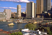
Circular Quay ferry wharf, Sydney
Encyclopedia
Circular Quay Ferry Wharf is the complex of the main commuter wharves
in Circular Quay in Sydney
, Australia
. It is part of the Sydney Ferries
network. It is the terminus for all public ferry routes in Sydney.
The Circular Quay Wharf complex has a setup of five jetties, labelled Wharf 2 to Wharf 6. Wharf 1 is a minor wharf on the east side of Circular Quay used for tourist vessels. Wharf 6 is also used for tourist vessels and other private charters.
Wharf 3
Wharf 4
Wharf 5
Wharf 6
Circular Quay West
 Circular Quay is adjacent to an elevated railway station of the same name. The station is served by trains on the Bankstown Line, Inner West Line, Airport & East Hills Line, and South Line
.
Beyond the railway station is the Sydney Buses Alfred Street terminus. A large number of Sydney Buses services originate from this stop. They are:
Stand A:
Stand B:
Stand C:
Stand D:
Stand E:
Wharf
A wharf or quay is a structure on the shore of a harbor where ships may dock to load and unload cargo or passengers.Such a structure includes one or more berths , and may also include piers, warehouses, or other facilities necessary for handling the ships.A wharf commonly comprises a fixed...
in Circular Quay in Sydney
Sydney
Sydney is the most populous city in Australia and the state capital of New South Wales. Sydney is located on Australia's south-east coast of the Tasman Sea. As of June 2010, the greater metropolitan area had an approximate population of 4.6 million people...
, Australia
Australia
Australia , officially the Commonwealth of Australia, is a country in the Southern Hemisphere comprising the mainland of the Australian continent, the island of Tasmania, and numerous smaller islands in the Indian and Pacific Oceans. It is the world's sixth-largest country by total area...
. It is part of the Sydney Ferries
Sydney Ferries
Sydney Ferries is an agency of the New South Wales Government Department of Transport, providing ferry services on Sydney Harbour and the Parramatta River in Sydney, Australia....
network. It is the terminus for all public ferry routes in Sydney.
The Circular Quay Wharf complex has a setup of five jetties, labelled Wharf 2 to Wharf 6. Wharf 1 is a minor wharf on the east side of Circular Quay used for tourist vessels. Wharf 6 is also used for tourist vessels and other private charters.
Ferry services
Wharf 2- Taronga Zoo Ferry - services to Taronga Zoo
- Mosman Ferry - (Sundays only) - services to Mosman Bay via Taronga Zoo
Wharf 3
- Manly Ferry - services to Manly
Wharf 4
- Watsons Bay Ferry - services to Rose Bay and Watsons Bay
- Mosman Ferry - services to Mosman Bay
- Neutral Bay Ferry - express services to Manly
- Balmain Ferry - (Sundays only) - services to Woolwich
- Harbour Cruises run by Sydney Ferries
Wharf 5
- Balmain Ferry - services to Woolwich and Drummoyne
- Parramatta Ferry - express services to Parramatta
- Rydalmere Ferry - services to Meadowbank, Sydney Olympic Park and Rydalmere
- Birkenhead Ferry - services to Birkenhead
- Pyrmont Bay Ferry - services to Pyrmont Bay
Wharf 6
- Harbour cruises
Circular Quay West
- Matilda CruisesMatilda CruisesMatilda Cruises operates commuter ferry and cruise services on Sydney Harbour in Sydney, Australia. The company is a subsidiary of Captain Cook Cruises.-Fleet:*Matilda*Matilda III*Aussie Venture*Aussie Magic*Aussie One*Aussie Legend*Alice*Megan...
services to Lane Cove RiverLane Cove RiverThe Lane Cove River is a tributary of the Parramatta River, Sydney, Australia. Its lower reaches form an arm of Sydney Harbour.-Description:...
and Darling Harbour
Public transport interchange
South railway line, Sydney
The South Line is a railway line in Sydney, New South Wales, Australia, and is part of the CityRail suburban network...
.
Beyond the railway station is the Sydney Buses Alfred Street terminus. A large number of Sydney Buses services originate from this stop. They are:
Stand A:
- 423 - to KingsgroveKingsgrove, New South WalesKingsgrove is a suburb in southern Sydney, in the state of New South Wales, Australia. Kingsgrove is located 13 kilometres south of the Sydney central business district and lies across the local government areas of the City of Rockdale, the City of Hurstville and the City of Canterbury...
Bus Depot (Richland Street) - 428 - to CanterburyCanterbury, New South Wales-Commercial area:Canterbury has a mixture of residential, commercial and industrial developments. Commercial developments are mostly situated on Canterbury Road and surrounding streets...
(Broughton Street, near Canterbury Railway StationCanterbury railway station, Sydney-Accessibility:The station has street access to both platforms via stairs. This does not allow for Easy Access for wheelchairs.-Transport links:Sydney Buses runs six routes via Canterbury station:... - 422 - to TempeTempe, New South WalesTempe is a suburb in the inner west of Sydney, in the state of New South Wales, Australia. Tempe is located 9 kilometres south of the Sydney central business district in the local government area of Marrickville Council....
Bus Depot; to Newtown, New South WalesNewtown, New South WalesNewtown, a suburb of Sydney's inner west is located approximately four kilometres south-west of the Sydney central business district, straddling the local government areas of the City of Sydney and Marrickville Council in the state of New South Wales, Australia....
Bridge (King Street) - 426 - to Dulwich HillDulwich Hill, New South WalesDulwich Hill is a residential suburb in the Inner West of Sydney, in the state of New South Wales, Australia. Dulwich Hill is located 9 kilometres south-west of the Sydney central business district, in the local government area of Marrickville Council...
(Marrickville Road near New Canterbury Road) - 431 - to Glebe PointGlebe Point, New South WalesGlebe Point is a locality in the suburb of Glebe, in the Inner West of Sydney, in the state of New South Wales, Australia.- External links :*...
Stand B:
- 111 - Sydney Explorer tourist bus (inbound)
- 222 - Bondi Explorer tourist bus (outbound)
Stand C:
- 438 - to AbbotsfordAbbotsford, New South WalesAbbotsford is a suburb in the Inner West region of Sydney, in the state of New South Wales, Australia. Abbotsford is located 10 kilometres west of the Sydney central business district in the local government area of the City of Canada Bay...
- (Great North Road and The Terrace) - 501 - to West Ryde Railway Station Interchange
- 470 - to LilyfieldLilyfield, New South WalesLilyfield is a small suburb in the Inner West of Sydney, in the state of New South Wales, Australia. Lilyfield is located 6 kilometres west of the Sydney central business district, in the local government area of the Municipality of Leichhardt....
- (Lilyfield Road and Trevor Street) - 443 - to Pyrmont BayPyrmont, New South WalesPyrmont is an inner-city suburb of Sydney, in the state of New South Wales, Australia. Pyrmont is located 2 kilometres south-west of the Sydney central business district in the local government area of the City of Sydney...
- (Australian Maritime Museum) - 506 - to East RydeEast Ryde, New South WalesEast Ryde is a suburb in the Northern Suburbs of Sydney, in the state of New South Wales, Australia. East Ryde is located 12 kilometres north-west of the Sydney central business district, in the local government area of the City of Ryde. East Ryde sits on the western bank of the Lane Cove River...
- (Sager Place and Elliott Avenue) - 440 - to RozelleRozelle, New South WalesRozelle is a suburb in the inner west of Sydney, in the state of New South Wales, Australia. It is located 4 kilometres west of the Sydney central business district, in the local government area of the Municipality of Leichhardt....
- (Darling Street and Waterloo Street) - 439 - to MortlakeMortlake, New South WalesMortlake is a suburb in the inner-west of Sydney, in the state of New South Wales, Australia. Mortlake is located 17 kilometres west of the Sydney central business district, in the local government area of the City of Canada Bay.-Transport:...
- (Whittaker Street) - 504 - to ChiswickChiswick, New South WalesChiswick is a suburb in the inner-west region of Sydney, in the state of New South Wales, Australia. It is located 9 kilometres west of the Sydney central business district in the local government area of the City of Canada Bay. Chiswick sits on the peninsula between Abbotsford Bay and Five Dock...
- (Blackwall Point Road and Bortfield Drive) - 506 - to Macquarie UniversityMacquarie UniversityMacquarie University is an Australian public teaching and research university located in Sydney, with its main campus situated in Macquarie Park. Founded in 1964 by the New South Wales Government, it was the third university to be established in the metropolitan area of Sydney...
- 436 - to ChiswickChiswick, New South WalesChiswick is a suburb in the inner-west region of Sydney, in the state of New South Wales, Australia. It is located 9 kilometres west of the Sydney central business district in the local government area of the City of Canada Bay. Chiswick sits on the peninsula between Abbotsford Bay and Five Dock...
- (Blackwall Point Road and Bortfield Drive) - M52 - metrobusMetrobus (Sydney)Metrobus is a high frequency, high capacity public transportation network in Sydney that links key employment and growth centres. Metrobuses run every 10 minutes during peak periods, 15 minutes during off-peak weekday periods, and 20 minutes on weekends, with the intention of making timetables...
service to Parramatta Railway Station Interchange, Stand B3 - 518 - to Macquarie UniversityMacquarie UniversityMacquarie University is an Australian public teaching and research university located in Sydney, with its main campus situated in Macquarie Park. Founded in 1964 by the New South Wales Government, it was the third university to be established in the metropolitan area of Sydney...
. - 507 - to Macquarie UniversityMacquarie UniversityMacquarie University is an Australian public teaching and research university located in Sydney, with its main campus situated in Macquarie Park. Founded in 1964 by the New South Wales Government, it was the third university to be established in the metropolitan area of Sydney...
. - 470 - to LeichhardtLeichhardt, New South WalesLeichhardt is a suburb in the inner-west of Sydney in New South Wales, Australia. Leichhardt is located 5 kilometres west of the Sydney central business district and is the administrative centre for the local government area of the Municipality of Leichhardt...
- (Lord Street and Flood Street) - 507 - to Top Ryde - (Blaxland Road and Devlin Street)
- L38 - to AbbotsfordAbbotsford, New South WalesAbbotsford is a suburb in the Inner West region of Sydney, in the state of New South Wales, Australia. Abbotsford is located 10 kilometres west of the Sydney central business district in the local government area of the City of Canada Bay...
(Great North Road and The Terrace) - 515 - to Eastwood Railway Station
- 518 - to Denistone EastDenistone East, New South WalesDenistone East is a suburb in the Northern Suburbs of Sydney, in the state of New South Wales, Australia. Denistone East is located 16 kilometres north-west of the Sydney central business district in the local government area of the City of Ryde...
(North Road and Tallwood Road) or to Macquarie UniversityMacquarie UniversityMacquarie University is an Australian public teaching and research university located in Sydney, with its main campus situated in Macquarie Park. Founded in 1964 by the New South Wales Government, it was the third university to be established in the metropolitan area of Sydney...
(Macquarie Drive) during peak hour. - 500 - to RydeRyde, New South WalesRyde is a suburb of Sydney, New South Wales, Australia. Ryde is located 13 km north-west of the Sydney central business district and 8 km east of Parramatta. Ryde is the administrative centre of the local government area of the City of Ryde and part of the Northern Suburbs area...
- (Civic Centre) - 520 - to Parramatta Railway Station Interchange, Stand B3 (early evening and late night service)
- 500 - to RydeRyde, New South WalesRyde is a suburb of Sydney, New South Wales, Australia. Ryde is located 13 km north-west of the Sydney central business district and 8 km east of Parramatta. Ryde is the administrative centre of the local government area of the City of Ryde and part of the Northern Suburbs area...
- (Blaxland and Church Streets)
Stand D:
- 373 - to CoogeeCoogee, New South WalesCoogee is a beachside suburb of local government area City of Randwick. It is located 8 kilometres south-east of the Sydney central business district, in the state of New South Wales, Australia. It is also a part of the Eastern Suburbs of Sydney....
- (Arden and Dolphin Streets) - 309 - to MatravilleMatraville, New South WalesMatraville is an older established area of the lower Eastern Suburbs of Sydney, in the state of New South Wales, Australia. Matraville is located approximately 9 kilometres by road south-east of the Sydney central business district, in the local government area of the City of...
- (Port Botany Terminus) - 324 - to Watsons BayWatsons Bay, New South WalesWatsons Bay is a harbourside, eastern suburb of Sydney, in the state of New South Wales, Australia. Watsons Bay is located 11 km north-east of the Sydney central business district, in the local government area of the Municipality of Woollahra....
- (Military Road Terminus) - 303 - to Sans SouciSans Souci, New South WalesSans Souci is a southern Sydney suburb in the state of New South Wales, Australia. Sans Souci is 17 kilometres south of the Sydney central business district and lies across the local government areas of the City of Rockdale and the Municipality of Kogarah. It is part of the St George area.Sans...
- (Botany Road and Hollingshed Street) - 303 - to Sans SouciSans Souci, New South WalesSans Souci is a southern Sydney suburb in the state of New South Wales, Australia. Sans Souci is 17 kilometres south of the Sydney central business district and lies across the local government areas of the City of Rockdale and the Municipality of Kogarah. It is part of the St George area.Sans...
- (Wellington Street and Rocky Point Road) - 377 - to MaroubraMaroubra, New South WalesMaroubra is a beachside suburb in the Eastern Suburbs of Sydney, in the state of New South Wales, Australia. Maroubra is located 10 kilometres south-east of the Sydney central business district in the local government area of the City of Randwick. Maroubra is the largest suburb in the area governed...
- (Maroubra Beach) - 301 - to NewtownNewtown, New South WalesNewtown, a suburb of Sydney's inner west is located approximately four kilometres south-west of the Sydney central business district, straddling the local government areas of the City of Sydney and Marrickville Council in the state of New South Wales, Australia....
- (King Street and Botany Road) - 310 - to PagewoodPagewood, New South WalesPagewood is a suburb in south-eastern Sydney, in the state of New South Wales, Australia. Pagewood is located 8 kilometres south-east of the Sydney central business district and is part of the City of Botany Bay....
- (Eastgardens Shopping Centre - Bunnerong Road and Wentworth Avenue) - 374 - to CoogeeCoogee, New South WalesCoogee is a beachside suburb of local government area City of Randwick. It is located 8 kilometres south-east of the Sydney central business district, in the state of New South Wales, Australia. It is also a part of the Eastern Suburbs of Sydney....
- (Arden and Dolphin Streets) - 301 - to PagewoodPagewood, New South WalesPagewood is a suburb in south-eastern Sydney, in the state of New South Wales, Australia. Pagewood is located 8 kilometres south-east of the Sydney central business district and is part of the City of Botany Bay....
- (Eastgardens Shopping Centre - Bunnerong Road and Wentworth Avenue) - 325 - to Watsons BayWatsons Bay, New South WalesWatsons Bay is a harbourside, eastern suburb of Sydney, in the state of New South Wales, Australia. Watsons Bay is located 11 km north-east of the Sydney central business district, in the local government area of the Municipality of Woollahra....
- (Military Road Terminus) - 326 - to Bondi Junction Railway Station Bus Interchange
- 376 - to MaroubraMaroubra, New South WalesMaroubra is a beachside suburb in the Eastern Suburbs of Sydney, in the state of New South Wales, Australia. Maroubra is located 10 kilometres south-east of the Sydney central business district in the local government area of the City of Randwick. Maroubra is the largest suburb in the area governed...
- (Maroubra Beach) - 302 - to PagewoodPagewood, New South WalesPagewood is a suburb in south-eastern Sydney, in the state of New South Wales, Australia. Pagewood is located 8 kilometres south-east of the Sydney central business district and is part of the City of Botany Bay....
- (Eastgardens Shopping Centre lower level) - 309 - to MatravilleMatraville, New South WalesMatraville is an older established area of the lower Eastern Suburbs of Sydney, in the state of New South Wales, Australia. Matraville is located approximately 9 kilometres by road south-east of the Sydney central business district, in the local government area of the City of...
- (Matraville Hotel - Bunnerong Road and Franklin Road) - 309 - to ChifleyChifley, New South WalesChifley is a suburb in south-eastern Sydney, in the state of New South Wales, Australia. Chifley is located 13km south east of the Sydney central business district and is part of the City of Randwick. The postcode is 2036...
- (Bunnerong Road and Moorina Road)
Stand E:
- 394 - to Little BayLittle Bay, New South WalesLittle Bay is a suburb in south-eastern Sydney, in the state of New South Wales, Australia. Little Bay is located 14 kilometres south-east of the Sydney central business district and is part of the local government area of the City of Randwick....
- (Anzac Parade at Prince Henry Hospital) - 396 - to MaroubraMaroubra, New South WalesMaroubra is a beachside suburb in the Eastern Suburbs of Sydney, in the state of New South Wales, Australia. Maroubra is located 10 kilometres south-east of the Sydney central business district in the local government area of the City of Randwick. Maroubra is the largest suburb in the area governed...
- (Maroubra Beach) - 394 - to La PerouseLa Perouse, New South WalesLapérouse is a suburb in south-eastern Sydney, in the state of New South Wales, Australia. The suburb of Lapérouse is located about 14 kilometres south-east of the Sydney central business district, in the City of Randwick....
- (Anzac Parade Terminus) - 380 - to North BondiNorth Bondi, New South WalesNorth Bondi is a coastal, eastern suburb of Sydney, in the state of New South Wales, Australia. North Bondi is located 7 kilometres east of the Sydney central business district, in the local government area of Waverley Council....
terminus - 389 - to North BondiNorth Bondi, New South WalesNorth Bondi is a coastal, eastern suburb of Sydney, in the state of New South Wales, Australia. North Bondi is located 7 kilometres east of the Sydney central business district, in the local government area of Waverley Council....
terminus - 380 - to Dover HeightsDover Heights, New South WalesDover Heights is a coastal, eastern suburb of Sydney, in the state of New South Wales, Australia. Dover Heights is located 9 kilometres east of the Sydney central business district, in the local government area of Waverley Council...
- (Military Road and Old South Head Road) - 311 - to Railway Square (Central Railway Station)Central railway station, SydneyCentral Railway Station, the largest railway station in Australia, is at the southern end of the Sydney CBD. It services almost all the lines on the CityRail network, and is the major terminus for interurban and interstate rail services...
- 392 - to Little BayLittle Bay, New South WalesLittle Bay is a suburb in south-eastern Sydney, in the state of New South Wales, Australia. Little Bay is located 14 kilometres south-east of the Sydney central business district and is part of the local government area of the City of Randwick....
- (Anzac Parade at Prince Henry Hospital) - 399 - to Little BayLittle Bay, New South WalesLittle Bay is a suburb in south-eastern Sydney, in the state of New South Wales, Australia. Little Bay is located 14 kilometres south-east of the Sydney central business district and is part of the local government area of the City of Randwick....
- (Anzac Parade at Prince Henry Hospital) - L94 - to La PerouseLa Perouse, New South WalesLapérouse is a suburb in south-eastern Sydney, in the state of New South Wales, Australia. The suburb of Lapérouse is located about 14 kilometres south-east of the Sydney central business district, in the City of Randwick....
- (Anzac Parade Terminus) - 397 - to South MaroubraMaroubra, New South WalesMaroubra is a beachside suburb in the Eastern Suburbs of Sydney, in the state of New South Wales, Australia. Maroubra is located 10 kilometres south-east of the Sydney central business district in the local government area of the City of Randwick. Maroubra is the largest suburb in the area governed...
- (Minneapolis Street and Midway Street) - 380 - to Watsons BayWatsons Bay, New South WalesWatsons Bay is a harbourside, eastern suburb of Sydney, in the state of New South Wales, Australia. Watsons Bay is located 11 km north-east of the Sydney central business district, in the local government area of the Municipality of Woollahra....
- (Military Road Terminus) - L82 - to Watsons BayWatsons Bay, New South WalesWatsons Bay is a harbourside, eastern suburb of Sydney, in the state of New South Wales, Australia. Watsons Bay is located 11 km north-east of the Sydney central business district, in the local government area of the Municipality of Woollahra....
- (Military Road Terminus) - 394 - to Maroubra JunctionMaroubra Junction, New South WalesMaroubra Junction is a locality of the suburb of Maroubra in Sydney, in the state of New South Wales, Australia. It is situated around the junction of Anzac Parade and Maroubra Road...
- (Anzac Parade and Green Street)
Neighbouring wharves
External links
- Sydney Ferries - official website
- Sydney Buses - Website for bus links