Choquequirao
Encyclopedia


Machu Picchu
Machu Picchu is a pre-Columbian 15th-century Inca site located above sea level. It is situated on a mountain ridge above the Urubamba Valley in Peru, which is northwest of Cusco and through which the Urubamba River flows. Most archaeologists believe that Machu Picchu was built as an estate for...
. The ruins are buildings and terraces at levels above and below Sunch'u Pata, the truncated hill top. The hilltop was anciently leveled and ringed with stones to create a 30x50 platform.
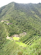
Choquequirao (3,050 m) is in the spurs of the Salkantay Mountain Range in the Province La Convención in the Cusco
Cusco Region
Cusco is a region in Peru. It is bordered by the Ucayali Region on the north; the Madre de Dios and Puno regions on the east; the Arequipa Region on the south; and the Apurímac, Ayacucho and Junín regions on the west...
region above the valley of river Río Apurímac
Apurímac River
The Apurímac River rises from glacial meltwater of the ridge of Nevado Mismi, a mountain in the Arequipa Province in southern Peru.The Apurímac is the source of the world's largest river system, the Amazon River...
. The complex is 1,800 hectares, of which 30-40% is excavated.
The site is reached by a two-day hike from outside Cusco
Cusco
Cusco , often spelled Cuzco , is a city in southeastern Peru, near the Urubamba Valley of the Andes mountain range. It is the capital of the Cusco Region as well as the Cuzco Province. In 2007, the city had a population of 358,935 which was triple the figure of 20 years ago...
.
History
The site was built during the reign of the Inca king Pachacuti Inca Yupanqui. It may be the last bastion of resistance and refuge of the Sons of the Sun who fled CuscoCusco
Cusco , often spelled Cuzco , is a city in southeastern Peru, near the Urubamba Valley of the Andes mountain range. It is the capital of the Cusco Region as well as the Cuzco Province. In 2007, the city had a population of 358,935 which was triple the figure of 20 years ago...
when it was under siege in 1535. Led by Manco Inca Yupanqui
Manco Inca Yupanqui
Manco Inca Yupanqui was one of the Incas of Vilcabamba. He was also known as "Manco II" and "Manco Cápac II" . Born in 1516, he was one of the sons of Huayna Cápac and came from a lower class of the nobility.Túpac Huallpa, a puppet ruler crowned by conquistador Francisco Pizarro, died in 1533...
they took refuge in Choquequirao.
According to the Peruvian Tourism Office, "Choquequirao was probably one of the entrance check point to the Vilcabamba region, and also an administrative hub serving political, social and economic functions. Its urban design has followed the symbolic patterns of the imperial capital, with ritual places dedicated to the Sun (Inti) and the ancestors, to the earth, water and other divinities, with mansions for administrators and houses for artisans, warehouses, large dormitories or kallankas and farming terraces belonging to the Inca or the local people. Spreading over 700 meters, the ceremonial area drops as much as 65 meters from the elevated areas to the main square."
Presumably it was used as a check point for access to the Vilcabamba
Vilcabamba, Peru
Vilcabamba was a city founded by Manco Inca in 1539 and was the last refuge of the Inca Empire until it fell to the Spaniards in 1572, signaling the end of Inca resistance to Spanish rule.- History :...
Area and as a cultural and religious center for the region. The city also played an important role as a link between the Amazon Jungle
Amazon Rainforest
The Amazon Rainforest , also known in English as Amazonia or the Amazon Jungle, is a moist broadleaf forest that covers most of the Amazon Basin of South America...
and the city of Cusco
Cusco
Cusco , often spelled Cuzco , is a city in southeastern Peru, near the Urubamba Valley of the Andes mountain range. It is the capital of the Cusco Region as well as the Cuzco Province. In 2007, the city had a population of 358,935 which was triple the figure of 20 years ago...
.
Layout
The typical Inca terraces form the largest constructions on site. A temple, some administrative buildings and the living quarters of the aristocrats are situated around the central square. On the outskirts of the site lie the living quarters of the common people grouped together in a small village. There are water channels, aqueducts and water springs. Most buildings are well-preserved and well-restored; restoration continues.Access
The Peruvian government plans a cable car to reach the ruins. Others have proposed a train similar to that used to Macchu Picchu.Discovery
According to Ethan Todras-Whitehill of the New York Times, Choquequirao's first non-Incan visitor was the explorer Juan Arias Díaz in 1710. The first written site reference in 1768 was made by Cosme Bueno, but was ignored at the time. In 1834 Eugene de Santiges rediscovered the site. In 1837 Leonce Agrand mapped the site for the first time, but his maps were forgotten. When Hiram BinghamHiram Bingham III
Hiram Bingham, formally Hiram Bingham III, was an academic, explorer, treasure hunter and politician from the United States. He made public the existence of the Quechua citadel of Machu Picchu in 1911 with the guidance of local indigenous farmers...
, the discoverer of Machu Picchu
Machu Picchu
Machu Picchu is a pre-Columbian 15th-century Inca site located above sea level. It is situated on a mountain ridge above the Urubamba Valley in Peru, which is northwest of Cusco and through which the Urubamba River flows. Most archaeologists believe that Machu Picchu was built as an estate for...
, visited Choquequirao in 1909 the site gained more attention. The first excavations started in the 1970s.
External links
- The Other Machu Picchu article on Choquequirao (The New York Times, June 3, 2007)
- Debate on the value of publicizing Choquequirao as a travel destination from the author of the New York Times article
- Photos Cachora-Choquequirao Trek
- Images of Choquequirao - High Definition Video

