

Apurímac River
Encyclopedia
The Apurímac River rises from glacial
meltwater of the ridge of Nevado Mismi
, a 5597 metres (18,362.9 ft) mountain in the Arequipa Province
in southern Peru
.
 The Apurímac is the source of the world's largest river system, the Amazon River
. It rises in Peru's south-western cordillera
s, 10 km (6.2 mi) from the village of Caylloma, and less than 160 km (99.4 mi) from the Pacific coast.
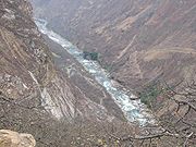
It flows generally northwest past Cuzco
in narrow gorges of up to 3,000 m, twice as deep as the Grand Canyon
in the USA, its course interrupted by falls and rapids. Of the six attempts so far to travel the Apurímac in its full length, only two have been successful.
After 730.7 kilometres (454 mi), the Apurímac joins the Mantaro River
and becomes the Ene River
at 12°15′46"S 73°58′44"W, 440 m (1,443.6 ft) above sea level; then after joining the Perené River
at 330 m (1,082.7 ft) above sea level, it becomes the Tambo River; when it joins the Urubamba
at 280 m (918.6 ft) above sea level the river becomes the Ucayali, which is the main headstream of the Amazon.
Sometimes the complete river from its source to its junction with the Ucayáli, i.e. including the rivers Ene and Tambo, is called "Apurímac", with a total length of 1069.8 km (664.7 mi).
Glacier
A glacier is a large persistent body of ice that forms where the accumulation of snow exceeds its ablation over many years, often centuries. At least 0.1 km² in area and 50 m thick, but often much larger, a glacier slowly deforms and flows due to stresses induced by its weight...
meltwater of the ridge of Nevado Mismi
Nevado Mismi
Nevado Mismi is a mountain peak of volcanic origin located in the Andes mountain range of Peru. A glacial stream on the Mismi was firmly identified as the most distant source of the Amazon River in 1996; this finding was confirmed in 2001 and again in 2007....
, a 5597 metres (18,362.9 ft) mountain in the Arequipa Province
Arequipa Province
Arequipa is a province in the Arequipa Region, Peru. It is the most populous province of the region, and its capital, Arequipa, is Peru's second-largest city...
in southern Peru
Peru
Peru , officially the Republic of Peru , is a country in western South America. It is bordered on the north by Ecuador and Colombia, on the east by Brazil, on the southeast by Bolivia, on the south by Chile, and on the west by the Pacific Ocean....
.
Amazon River
The Amazon of South America is the second longest river in the world and by far the largest by waterflow with an average discharge greater than the next seven largest rivers combined...
. It rises in Peru's south-western cordillera
Cordillera
A cordillera is an extensive chain of mountains or mountain ranges, that runs along a coastline . It comes from the Spanish word cordilla, which is a diminutive of cuerda, or "cord"...
s, 10 km (6.2 mi) from the village of Caylloma, and less than 160 km (99.4 mi) from the Pacific coast.
It flows generally northwest past Cuzco
Cusco
Cusco , often spelled Cuzco , is a city in southeastern Peru, near the Urubamba Valley of the Andes mountain range. It is the capital of the Cusco Region as well as the Cuzco Province. In 2007, the city had a population of 358,935 which was triple the figure of 20 years ago...
in narrow gorges of up to 3,000 m, twice as deep as the Grand Canyon
Grand Canyon
The Grand Canyon is a steep-sided canyon carved by the Colorado River in the United States in the state of Arizona. It is largely contained within the Grand Canyon National Park, the 15th national park in the United States...
in the USA, its course interrupted by falls and rapids. Of the six attempts so far to travel the Apurímac in its full length, only two have been successful.
After 730.7 kilometres (454 mi), the Apurímac joins the Mantaro River
Mantaro River
The Mantaro River is a long river running through the central region of Peru. Its Quechua name means "great river".-Geography:The river has its source at Lake Junín at a height of 4.080 m and runs through Junín, Yauli, Jauja, Concepción and Huancayo provinces in Junín Region, then through...
and becomes the Ene River
Ene River
The Ene River is a Peruvian river on the eastern slopes of the South American Andes.The Río Ene is part of the headwaters of the Amazon River whose origin is at the Nevado Mismi south of Cuzco where it first becomes Apurímac River, then the Ene River and Tambo River before its waters meet the...
at 12°15′46"S 73°58′44"W, 440 m (1,443.6 ft) above sea level; then after joining the Perené River
Perené River
The Perené River is a Peruvian river on the eastern slopes of the South American Andes.It is formed at at the confluence of the Chanchamayo River and the Paucartambo rivers, 15 km above the community of Perené, at 650 m above sea level....
at 330 m (1,082.7 ft) above sea level, it becomes the Tambo River; when it joins the Urubamba
Urubamba River
The Urubamba River is a river in Peru. A partially navigable headwater of the Amazon River, it rises in the Andes to the south-east of Cuzco near the Puno Region border, where it is called the Vilcanota River . In the Sacred Valley, between Písac and Ollantaytambo, it is also called the Wilcamayu...
at 280 m (918.6 ft) above sea level the river becomes the Ucayali, which is the main headstream of the Amazon.
Sometimes the complete river from its source to its junction with the Ucayáli, i.e. including the rivers Ene and Tambo, is called "Apurímac", with a total length of 1069.8 km (664.7 mi).