
Cat and Fiddle Road
Encyclopedia
England
England is a country that is part of the United Kingdom. It shares land borders with Scotland to the north and Wales to the west; the Irish Sea is to the north west, the Celtic Sea to the south west, with the North Sea to the east and the English Channel to the south separating it from continental...
running between Buxton
Buxton
Buxton is a spa town in Derbyshire, England. It has the highest elevation of any market town in England. Located close to the county boundary with Cheshire to the west and Staffordshire to the south, Buxton is described as "the gateway to the Peak District National Park"...
, Derbyshire
Derbyshire
Derbyshire is a county in the East Midlands of England. A substantial portion of the Peak District National Park lies within Derbyshire. The northern part of Derbyshire overlaps with the Pennines, a famous chain of hills and mountains. The county contains within its boundary of approx...
and Macclesfield
Macclesfield
Macclesfield is a market town within the unitary authority of Cheshire East, the county palatine of Chester, also known as the ceremonial county of Cheshire, England. The population of the Macclesfield urban sub-area at the time of the 2001 census was 50,688...
, Cheshire
Cheshire
Cheshire is a ceremonial county in North West England. Cheshire's county town is the city of Chester, although its largest town is Warrington. Other major towns include Widnes, Congleton, Crewe, Ellesmere Port, Runcorn, Macclesfield, Winsford, Northwich, and Wilmslow...
, named after the public house
Cat and Fiddle Inn
The Cat and Fiddle Inn is the second-highest inn or public house in England . The inn is situated on the eastern fringes of Cheshire in the Peak District National Park on the A537 road just west of the Derbyshire/Cheshire county boundary, on the western side of Axe Edge Moor...
at its summit. Formed by parts of the A537
A537 road
The A537 is a road linking Knutsford, Cheshire and Buxton, Derbyshire. Part of the route includes the Cat and Fiddle Road, one of the most dangerous in Great Britain.-Route:...
, A54
A54 road
The A54 road is a road linking Chester in Cheshire, England with Buxton in Derbyshire. The road follows the route:*Chester*Winsford*Middlewich*Holmes Chapel*Congleton*Buxton...
and A53
A53 road
The A53 is a primary route in northern England, that runs from Buxton in Derbyshire to Shrewsbury in Shropshire.-Route of Road:The A53 begins in the centre of Buxton off the A6 road, before meeting the A515 road at a roundabout. Out of the town, it has a junction with the A54 road before...
it is famous for its scenic views across the Greater Manchester
Greater Manchester
Greater Manchester is a metropolitan county in North West England, with a population of 2.6 million. It encompasses one of the largest metropolitan areas in the United Kingdom and comprises ten metropolitan boroughs: Bolton, Bury, Oldham, Rochdale, Stockport, Tameside, Trafford, Wigan, and the...
conurbation, Peak District National Park and the Cheshire Plain
Cheshire Plain
The Cheshire Plain is a relatively flat expanse of lowland situated almost entirely within the county of Cheshire in northwest England. It is bounded by the hills of North Wales to the west, and the Peak District of Derbyshire and North Staffordshire to the east and southeast...
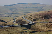
and for its many bends. It is extremely popular with motorcyclists, and is regularly classed as the most dangerous road in the UK.
Route
The road can be considered to start in Buxton at the junction of the A53 and A5004 Long Hill road just north of the Buxton Opera HouseBuxton Opera House
Buxton Opera House is in The Square, Buxton, Derbyshire, England. It is a 902-seat opera house that hosts the annual Buxton Festival and International Gilbert and Sullivan Festival, among others, as well as pantomime at Christmas, musicals and other entertainments year-round. Hosting live...
. It follows the A53 through the western outskirts of Buxton until a right turn onto the A54 at Ladmanlow. It then climbs out of Buxton in a series of sharp bends onto the flat moorland
Moorland
Moorland or moor is a type of habitat, in the temperate grasslands, savannas, and shrublands biome, found in upland areas, characterised by low-growing vegetation on acidic soils and heavy fog...
of Goyt’s Moss, where it runs along the A537 in a fairly straight line until reaching the Cat and Fiddle Inn
Cat and Fiddle Inn
The Cat and Fiddle Inn is the second-highest inn or public house in England . The inn is situated on the eastern fringes of Cheshire in the Peak District National Park on the A537 road just west of the Derbyshire/Cheshire county boundary, on the western side of Axe Edge Moor...
at an altitude of 1690 feet (515.1 m). From the Cat and Fiddle Inn it descends to Macclesfield via a continuous series of sharp, and often blind, bends.
Usage
It is one of the only two roads into Macclesfield from the east, and as such carries long distance as well as local traffic, including heavy goods vehicles. It is also carries tourist traffic into the Peak District National Park including bicycles and walkers. It also forms part of the well-known ‘Cat and Fiddle – Long Hill – HighwaymanB5470 road
The B5470 is a road in England, running from Chapel-en-le-Frith, Derbyshire to Macclesfield, Cheshire via Whaley Bridge, Derbyshire. The hilly and winding section between Whaley Bridge and Macclesfield is often called ‘The Highwayman’ after a prominent roadside pub...
’ triangle, which is particularly attractive to motorcyclists because of the frequency and severity of the bends. Given this mixture of usage, the number and sharpness of the bends and the fact that it is not uncommon to encounter straying livestock on the road, it is necessary to employ a great deal of caution. Bad winter weather can additionally make the road very hazardous.
Road safety initiatives
Mobile speed camera
A mobile speed camera is speed limit enforcement device used in the United Kingdom to refer to a road vehicle fitted with speed camera equipment which can park at the side of the road, or on overbridges to monitor the speed of passing traffic....
is used most weekends during the summer. A police aircraft is often used in conjunction with these to enforce the speed limit.
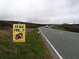
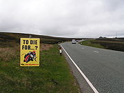
In June 2008 the road was yet again named as the most dangerous road in Britain by the Road Safety Foundation. This single-carriageway route was the location for 21 fatal and serious crashes, and was rated in the EuroRAP report as Black, the highest risk rating. This is in spite of a number of countermeasures installed by the road authority, including motorcycle-friendly barriers. The Foundation attributes this high number of accidents to road-user behaviour; indeed, when motorcycle-related collisions are removed from the results the road becomes one of the safest in the country.
Cheshire County Council also point the finger at motorcyclists' behaviour: "The fact is that it’s an attractive road to motorcyclists – they see it as a challenge to ride with its hairpin bends, limited views, downhill descent and uphill ascent.
"The thing that angers us most is not the fact that it’s dangerous, but that there are a group of people on that road who knowingly push the boundaries.
"We have tried to get the message across, that it is the emergency services that have to pick these people up off the road and have the duty of telling their families that they have killed themselves."
Having already spent £500,000 on a number of safety measures (including reducing the speed limit, installing high-friction surfacing, barriers and signs, widening the carriageway, and using mobile speed cameras , in January 2009 it was revealed that Cheshire Council, on behalf of Cheshire Safer Roads Partnership and Derbyshire Partnership for Road Safety, intended to spend a further £1.2 million on installing average-speed cameras along this road. Installation of these cameras began in February 2010.
However, the initial operation of the camera did not go smoothly, because along the full route of the camera's operation there are a number of shortcuts which have the full national speed (60 mph) and also decrease the overall distance of the route. These two factors, when combined, can give false reading to the speed cameras.
The average-speed camera scheme is a joint initiative between the Cheshire Safer Roads Partnership (including Cheshire East Council); Derby and Derbyshire Road Safety Partnership; and the Department for Transport, and enables the average speed of vehicles along the 50 mph route to be measured between any two cameras. Cameras will be installed along the A537 and A54 and will be rear-facing.
Lee Murphy, Cheshire Safer Roads Partnership Manager, says: “Major resources have been committed to the Cat and Fiddle road since 2000, including reducing the speed limit; high friction surfacing; high visibility warning signs; red warnings painted on the road; motorcycle-friendly safety barriers; enforcement signs; carriageway widening; mobile safety cameras; and police operations. Even without police costs, we estimate that more than £500,000 has been spent on the road in Cheshire alone. Despite all this work, casualties remain high."
Of the 264 casualties on the road since 2001, approximately 70% of those killed or seriously injured were motorcyclists, with the main causes being poor cornering/manoeuvring; exceeding the speed limit; and failing to judge another vehicle’s speed/distance. “The information and statistics show that it is riding behaviour not the road condition that causes the majority of collisions. We don’t have a problem with other road users not seeing bikes, because the majority of collisions are single vehicles,” adds Murphy.
In June 2010, the road was named as the UK's most dangerous in a survey by the Road Safety Foundation, with the report claiming that fatalities on the road rose from 15 in the three years to 2005 to 34 between 2006 and 2008.