
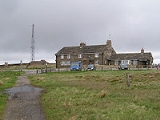
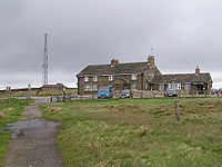
Cat and Fiddle Inn
Encyclopedia
Public house
A public house, informally known as a pub, is a drinking establishment fundamental to the culture of Britain, Ireland, Australia and New Zealand. There are approximately 53,500 public houses in the United Kingdom. This number has been declining every year, so that nearly half of the smaller...
in England
England
England is a country that is part of the United Kingdom. It shares land borders with Scotland to the north and Wales to the west; the Irish Sea is to the north west, the Celtic Sea to the south west, with the North Sea to the east and the English Channel to the south separating it from continental...
(the Tan Hill Inn
Tan Hill, Yorkshire
Tan Hill is a high point on the Pennine Way in North Yorkshire, England north of the village of Keld, near the borders with County Durham and Cumbria and close to the northern boundary of the Yorkshire Dales National Park.-Tan Hill Inn:...
being the highest). The inn is situated on the eastern fringes of Cheshire
Cheshire
Cheshire is a ceremonial county in North West England. Cheshire's county town is the city of Chester, although its largest town is Warrington. Other major towns include Widnes, Congleton, Crewe, Ellesmere Port, Runcorn, Macclesfield, Winsford, Northwich, and Wilmslow...
in the Peak District
Peak District
The Peak District is an upland area in central and northern England, lying mainly in northern Derbyshire, but also covering parts of Cheshire, Greater Manchester, Staffordshire, and South and West Yorkshire....
National Park
National park
A national park is a reserve of natural, semi-natural, or developed land that a sovereign state declares or owns. Although individual nations designate their own national parks differently A national park is a reserve of natural, semi-natural, or developed land that a sovereign state declares or...
on the A537 road
A537 road
The A537 is a road linking Knutsford, Cheshire and Buxton, Derbyshire. Part of the route includes the Cat and Fiddle Road, one of the most dangerous in Great Britain.-Route:...
just west of the Derbyshire
Derbyshire
Derbyshire is a county in the East Midlands of England. A substantial portion of the Peak District National Park lies within Derbyshire. The northern part of Derbyshire overlaps with the Pennines, a famous chain of hills and mountains. The county contains within its boundary of approx...
/Cheshire county
County
A county is a jurisdiction of local government in certain modern nations. Historically in mainland Europe, the original French term, comté, and its equivalents in other languages denoted a jurisdiction under the sovereignty of a count A county is a jurisdiction of local government in certain...
boundary, on the western side of Axe Edge Moor
Axe Edge Moor
Axe Edge Moor is the major moorland west of Buxton in the Peak District. It is mainly gritstone . Its highest point is at . This is slightly lower than Shining Tor .The moor is the source of the River Dove, River Manifold, River Dane, River Wye and River Goyt...
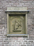
. It is at an elevation of 1689 feet (514.8 m) above sea level (although a recent measurement commissioned by the landlord suggested a figure of 1772 feet (540.1 m), which would surpass that of the Tan Hill Inn). The Ordnance Survey have fixed an accurately measured flush-bracket benchmark
Benchmark (surveying)
The term bench mark, or benchmark, originates from the chiseled horizontal marks that surveyors made in stone structures, into which an angle-iron could be placed to form a "bench" for a leveling rod, thus ensuring that a leveling rod could be accurately repositioned in the same place in the future...
to the front wall of the pub. The height of this flush bracket is 515.1984m, and the flush bracket is 0.4m above the ground level, which casts doubt over the validity of the landlord's survey.
There are a number of pubs of this name in the United Kingdom. Various etymologies
Etymology
Etymology is the study of the history of words, their origins, and how their form and meaning have changed over time.For languages with a long written history, etymologists make use of texts in these languages and texts about the languages to gather knowledge about how words were used during...
are claimed: some believe it is a corruption of le chat fidele ('the faithful cat'); others (including Brewer's Dictionary of Phrase and Fable
Brewer's Dictionary of Phrase and Fable
Brewer's Dictionary of Phrase and Fable, sometimes referred to simply as Brewer's, is a reference work containing definitions and explanations of many famous phrases, allusions and figures, whether historical or mythical.-History:...
) that it comes from 'Caton le Fidele' (a former governor of Calais
Calais
Calais is a town in Northern France in the department of Pas-de-Calais, of which it is a sub-prefecture. Although Calais is by far the largest city in Pas-de-Calais, the department's capital is its third-largest city of Arras....
); a third theory is that it derives from 'Catherine la Fidele' (Catherine of Aragon
Catherine of Aragon
Catherine of Aragon , also known as Katherine or Katharine, was Queen consort of England as the first wife of King Henry VIII of England and Princess of Wales as the wife to Arthur, Prince of Wales...
).
The inn is the last on the 45 miles (72.4 km) Four Inns Walk
Four Inns Walk
The Four Inns Walk is a hiking event held annually over the high moorlands of the Northern Peak District. It takes place mainly in Derbyshire , in northern England. It is organised by the Scout Association...
, held annually in spring, mainly over the high moorland to the north.
Cat and Fiddle Road
The inn gives its name to the Cat and Fiddle RoadCat and Fiddle Road
The Cat and Fiddle is a road in England running between Buxton, Derbyshire and Macclesfield, Cheshire, named after the public house at its summit. Formed by parts of the A537, A54 and A53 it is famous for its scenic views across the Greater Manchester conurbation, Peak District National Park and...
: a stretch of the A537 road
A537 road
The A537 is a road linking Knutsford, Cheshire and Buxton, Derbyshire. Part of the route includes the Cat and Fiddle Road, one of the most dangerous in Great Britain.-Route:...
, linking Macclesfield
Macclesfield
Macclesfield is a market town within the unitary authority of Cheshire East, the county palatine of Chester, also known as the ceremonial county of Cheshire, England. The population of the Macclesfield urban sub-area at the time of the 2001 census was 50,688...
to the west with Buxton
Buxton
Buxton is a spa town in Derbyshire, England. It has the highest elevation of any market town in England. Located close to the county boundary with Cheshire to the west and Staffordshire to the south, Buxton is described as "the gateway to the Peak District National Park"...
to the east, which features many sharp corners. This road became notorious for the high number of accidents, particularly among motorcyclists for whom the road is often regarded as an exhilarating technical challenge; an AA
The Automobile Association
The Automobile Association , a British motoring association founded in 1905 was demutualised in 1999 to become a private limited company which currently provides car insurance, driving lessons, breakdown cover, loans and motoring advice, and other services...
survey in 2003 named it as the most dangerous stretch of road in the United Kingdom.