
A54 road
Encyclopedia
The A54 road is a road linking Chester
in Cheshire
, England
with Buxton
in Derbyshire
. The road follows the route:
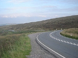
According to a report done by the Road Safety Foundation for the European Road Assessment Programme (EuroRAP), the A54 is one of the most dangerous roads in the UK, second only to the A682 in Lancashire
.
Again in 2008 the road was rated as one of the highest risk roads in Great Britain by EuroRAP
with a risk rating of Medium to High on its most dangerous stretch between Buxton and Congleton. This 24 km stretch of single carriageway road suffered 18 fatal and serious injury accidents between 2003 and 2005, 26% of which were accidents at junctions
Chester
Chester is a city in Cheshire, England. Lying on the River Dee, close to the border with Wales, it is home to 77,040 inhabitants, and is the largest and most populous settlement of the wider unitary authority area of Cheshire West and Chester, which had a population of 328,100 according to the...
in Cheshire
Cheshire
Cheshire is a ceremonial county in North West England. Cheshire's county town is the city of Chester, although its largest town is Warrington. Other major towns include Widnes, Congleton, Crewe, Ellesmere Port, Runcorn, Macclesfield, Winsford, Northwich, and Wilmslow...
, England
England
England is a country that is part of the United Kingdom. It shares land borders with Scotland to the north and Wales to the west; the Irish Sea is to the north west, the Celtic Sea to the south west, with the North Sea to the east and the English Channel to the south separating it from continental...
with Buxton
Buxton
Buxton is a spa town in Derbyshire, England. It has the highest elevation of any market town in England. Located close to the county boundary with Cheshire to the west and Staffordshire to the south, Buxton is described as "the gateway to the Peak District National Park"...
in Derbyshire
Derbyshire
Derbyshire is a county in the East Midlands of England. A substantial portion of the Peak District National Park lies within Derbyshire. The northern part of Derbyshire overlaps with the Pennines, a famous chain of hills and mountains. The county contains within its boundary of approx...
. The road follows the route:
- Chester
- WinsfordWinsfordWinsford is a town and civil parish within the unitary authority of Cheshire West and Chester and the ceremonial county of Cheshire, England. It lies on the River Weaver south of Northwich and west of Middlewich, and grew around the salt mining industry after the river was canalised in the...
- MiddlewichMiddlewichMiddlewich is a market town in the unitary authority of Cheshire East and the ceremonial county of Cheshire, England. It is east of the city of Chester, east of Winsford, southeast of Northwich and northwest of Sandbach....
- Holmes ChapelHolmes ChapelHolmes Chapel is a village and civil parish in the unitary authority of Cheshire East and the ceremonial county of Cheshire, England. Until 1974 the parish was known as Church Hulme.At the 2001 Census the population of the village was recorded as 5,669...
- CongletonCongletonCongleton is a town and civil parish in the unitary authority of Cheshire East and the ceremonial county of Cheshire, England, on the banks of the River Dane, to the west of the Macclesfield Canal and 21 miles south of Manchester. It has a population of 25,750.-History:The first settlements in...
- Buxton
According to a report done by the Road Safety Foundation for the European Road Assessment Programme (EuroRAP), the A54 is one of the most dangerous roads in the UK, second only to the A682 in Lancashire
Lancashire
Lancashire is a non-metropolitan county of historic origin in the North West of England. It takes its name from the city of Lancaster, and is sometimes known as the County of Lancaster. Although Lancaster is still considered to be the county town, Lancashire County Council is based in Preston...
.
Again in 2008 the road was rated as one of the highest risk roads in Great Britain by EuroRAP
EuroRAP
European Road Assessment Programme is a non-profit road safety organisation which aims to reduce death and serious injury on Europe's roads...
with a risk rating of Medium to High on its most dangerous stretch between Buxton and Congleton. This 24 km stretch of single carriageway road suffered 18 fatal and serious injury accidents between 2003 and 2005, 26% of which were accidents at junctions