
Carnarvon National Park
Encyclopedia
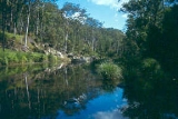
Carnarvon National Park is located in the Southern Brigalow Belt bioregion in Central Queensland
(Australia
), 593 km northwest of Brisbane
. It began life as a 26,304-hectare reserve gazetted in 1932 to protect Carnarvon Gorge
for its outstanding scenic values, its indigenous and non-indigenous cultural heritage, and its geological significance.
, Carnarvon National Park preserves and presents significant elements of Queensland
's geological history including two sedimentary basin
s, the Bowen
and the Surat
, and the Buckland Volcanic Province. The youngest rocks in the area are the igneous basalt rocks of the Buckland volcanic Province, which were laid down between 35 and 27 million years ago. Since that time, water and wind have eroded the park's landscapes into a network of sandy plains, valleys, and gorges separated by basalt-capped tablelands and ranges.
The park is rich in groundwater
, numerous springs
. The elevated areas protected within Carnarvon National Park have high value for above-ground catchments as well. Five major river systems rise within the park's boundary: the Comet
, Dawson, Maranoa
, Nogoa
, and Warrego
. The Warrego and Maranoa lie inland of the Great Dividing Range on the northern boundary of the Murray-Darling Basin
.
s are known to exist within the park and nine of them are listed as endangered, due to large-scale land clearing
within the region. Twenty-three species of flora listed as rare and threatened (Under Queensland
legislation) have been found in the park, including the iconic Livistona
nitida (Carnarvon Fan Palm, Carnarvon Gorge section), Cadellia pentastylis (Ooline, Moolayember section), and Stemmacantha australis (Austral Cornflower, Mount Moffatt section).
Several plants occur in disjunct populations, or reach the limits of their distribution, within the Park such as the isolated colony of Angiopteris evecta
(King Fern) found in Wards Canyon, Carnarvon Gorge
. Artesian spring
s in the Salvator Rosa section of the park are considered amongst the most biodiverse in the state.
s with at least twenty known to be there. The Ornithorhyncus anatinus, the platypus, is at its western limit of habitation in Queensland within this National Park, along with most of the park's gliding possums. Carnarvon Gorge has commercial night tours that take visitors into the park in search of gliders and other nocturnal life.
At least 90 species of reptiles call this park home, over half of which are either skink
s or gecko
es, and 35 species have their State distributional limits here. Twenty-two species of amphibians have been found in the park, including isolated populations of Litoria fallax (eastern Sedgefrog) and Adelotus brevis (Tusked Frog).
Over ten species of fish inhabit the park's waterways, the largest of which is Anguilla reinhardtii
(long-finned eel). The park's invertebrate fauna is thought to be extremely diverse, and at least nine species are considered to be endemic to the Carnarvon Range
, including two species of dragonfly, two species of stonefly, a dobson fly, and four species of land snail.
Feral
animals are present within the National Park, the ones presenting the most serious problems being Brumbies
and pigs. In 2007, culling of both species began by riflemen in helicopter
s or airplanes. In 2008 the third phase of an aerial culling of Brumbies took place, by shooting 700 horses from a helicopter, in Carnarvon National Park. Such aerial culling is a contentious issue to some members of the public. However, there is little doubt that both species cause considerable alteration to the values the park is designed to protect. Through their grazing
and their repetitious patterns of movement, feral horses alter the composition of the ground cover, and this can accelerate erosion through over-grazing and excessive hoof traffic. Feral pigs are thought to be responsible for the localised extinction of the Australian Brush-Turkey from some areas of this National Park.
In expanding the National Park, the Queensland National Parks and Wildlife Service have sought to enhance the reserves catchment value and increase the diversity of regional ecosystems protected within its boundaries. The park's regional conservation
importance is significant as its 298,000 hectares represents over half the total landmass of protected areas within the Southern Brigalow Belt bioregion.
cultural connection in rock art sites, burial places and occupation sites. Kenniff Cave, in the Mount Moffatt section, was the first Australian archaeological site to return carbon dates on occupational evidence that pushed human occupation of the continent into the Late Pleistocene
at 19,500 years before present. Prior to D.J. Mulvaney's excavation of Kenniff Cave, it was thought that Australia had only been occupied during the Holocene
, less than 10,000 years before present.
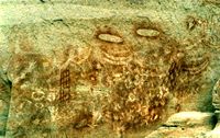 The indigenous stencil
artists of Central Queensland, such as those who created sites such as the Art Gallery and Cathedral Cave in Carnarvon Gorge
, are regarded by some researchers as the best in the world. It appears they developed complex stencilling techniques that have not been replicated elsewhere. Only one full adult body stencil is known to exist in the world; it can be seen publicly at the Tombs site in the Mount Moffatt section of the park. It is the largest known stencil, and a good example of the heights to which this form of human expression was taken in Central Queensland.
Contemporary indigenous culture in the park is much changed from that of pre-colonial Central Queensland; however strong Indigenous links to the landscapes within Carnarvon National Park are maintained through traditional owner involvement in the protection and preservation of the Park's cultural sites.
The first European to traverse the future park was Thomas Mitchell, in the 1840s. He named the Carnarvon Range after a location in Wales. Settlers followed in the footsteps of the explorers, lured by reports of the region's permanent water. Altercations with local Indigenous groups soon broke out and escalated into a state of mutual aggression that was maintained until the 1870s.
The remoteness of the area during early settlement attracted some interesting local characters, some of whom came to the area to avoid unwanted official scrutiny. The Ward brothers hunted fur in the Carnarvons year round at a time when there were restricted open seasons, and the Kenniff brothers (Kenniff Cave's namesakes) became notorious local horse thieves, and later murderers.
Today, tourism, recreation, and conservation are the main human activities conducted on the park. The most popular section of the park is the Carnarvon Gorge section which receives an estimated 65,000 visitors per year. Mount Moffatt is the next most visited section, followed by Salvator Rosa and Ka Ka Mundi. The remaining sections of the park receive virtually no visitation at all, and are consequently high in wilderness values.
Carnarvon National Park offers a variety of recreational activities including four-wheel driving, wildlife watching, hiking along maintained tracks, and bush walking into remote areas. A ninety-kilometre-long trail is currently underway that will allow bush walkers to circumnavigate Carnarvon Gorge in around five days.
or Injune
along the Carnarvon Highway
. The Mount Moffatt section is accessible from either Injune
or Mitchell
. The Salvator Rosa and Ka Ka Mundi sections are accessible via the Tambo Road from either Tambo
or Springsure
.
Central Queensland
Central Queensland is an ambiguous geographical division of Queensland that centres on the eastern coast, around the Tropic of Capricorn. Its major regional centre is Rockhampton and the Capricorn Coast and the area extends west to the Central Highlands at Emerald, north to the Mackay Regional...
(Australia
Australia
Australia , officially the Commonwealth of Australia, is a country in the Southern Hemisphere comprising the mainland of the Australian continent, the island of Tasmania, and numerous smaller islands in the Indian and Pacific Oceans. It is the world's sixth-largest country by total area...
), 593 km northwest of Brisbane
Brisbane
Brisbane is the capital and most populous city in the Australian state of Queensland and the third most populous city in Australia. Brisbane's metropolitan area has a population of over 2 million, and the South East Queensland urban conurbation, centred around Brisbane, encompasses a population of...
. It began life as a 26,304-hectare reserve gazetted in 1932 to protect Carnarvon Gorge
Carnarvon Gorge
Carnarvon Gorge is located in the Southern Brigalow Belt bioregion in Central Queensland , 593 km northwest of Brisbane. Primarily created by water erosion, Carnarvon Gorge is around 30 kilometres long, and six hundred metres deep at the mouth...
for its outstanding scenic values, its indigenous and non-indigenous cultural heritage, and its geological significance.
Rocks and landscapes
Situated within the Central Queensland Sandstone Belt, and straddling the Great Dividing RangeGreat Dividing Range
The Great Dividing Range, or the Eastern Highlands, is Australia's most substantial mountain range and the third longest in the world. The range stretches more than 3,500 km from Dauan Island off the northeastern tip of Queensland, running the entire length of the eastern coastline through...
, Carnarvon National Park preserves and presents significant elements of Queensland
Queensland
Queensland is a state of Australia, occupying the north-eastern section of the mainland continent. It is bordered by the Northern Territory, South Australia and New South Wales to the west, south-west and south respectively. To the east, Queensland is bordered by the Coral Sea and Pacific Ocean...
's geological history including two sedimentary basin
Sedimentary basin
The term sedimentary basin is used to refer to any geographical feature exhibiting subsidence and consequent infilling by sedimentation. As the sediments are buried, they are subjected to increasing pressure and begin the process of lithification...
s, the Bowen
Bowen Basin
The Bowen Basin contains the largest coal reserves in Australia. This major coal producing region contains one of the world's largest deposits of bituminous coal. The Basin contains much of the known Permian coal resources in Queensland including virtually all of the known mineable prime coking coal...
and the Surat
Surat Basin
The Surat Basin is a part of the Great Artesian Basin of Australia. The Surat Basin extends across an area of 270,000 square kilometres and the southern third of the basin occupies a large part of northern New South Wales, the remainder is in Queensland. It comprises Jurassic through to Cretaceous...
, and the Buckland Volcanic Province. The youngest rocks in the area are the igneous basalt rocks of the Buckland volcanic Province, which were laid down between 35 and 27 million years ago. Since that time, water and wind have eroded the park's landscapes into a network of sandy plains, valleys, and gorges separated by basalt-capped tablelands and ranges.
The park is rich in groundwater
Groundwater
Groundwater is water located beneath the ground surface in soil pore spaces and in the fractures of rock formations. A unit of rock or an unconsolidated deposit is called an aquifer when it can yield a usable quantity of water. The depth at which soil pore spaces or fractures and voids in rock...
, numerous springs
Spring (hydrosphere)
A spring—also known as a rising or resurgence—is a component of the hydrosphere. Specifically, it is any natural situation where water flows to the surface of the earth from underground...
. The elevated areas protected within Carnarvon National Park have high value for above-ground catchments as well. Five major river systems rise within the park's boundary: the Comet
Comet River
The Comet River is a river in Central Queensland that starts to the south of Rolleston. It then flows north through Comet towards a confluence with the Nogoa River where they both become known as the Mackenzie River...
, Dawson, Maranoa
Maranoa River
The Maranoa River is a large river situated in south west Queensland. The Maranoa passes through Mitchell and flows south towards St George. It is a tributary of the Balonne River which eventually flows into the Darling River , so it contributes to the Murray-Darling Basin.The river rises on the...
, Nogoa
Nogoa River
The Nogoa River rises on the Carnarvon Range in the Carnarvon National Park in Central Queensland and flows in a north easterly direction. The river ends where it meets the Comet River north of Comet. From this point the river is called the Mackenzie River....
, and Warrego
Warrego River
The Warrego River is situated in south west Queensland and north west New South Wales, Australia. It is the northernmost tributary of the Darling River....
. The Warrego and Maranoa lie inland of the Great Dividing Range on the northern boundary of the Murray-Darling Basin
Murray-Darling Basin
The Murray-Darling basin is a large geographical area in the interior of southeastern Australia, whose name is derived from its two major rivers, the Murray River and the Darling River. It drains one-seventh of the Australian land mass, and is currently by far the most significant agricultural...
.
Flora
Forty regional ecosystemEcosystem
An ecosystem is a biological environment consisting of all the organisms living in a particular area, as well as all the nonliving , physical components of the environment with which the organisms interact, such as air, soil, water and sunlight....
s are known to exist within the park and nine of them are listed as endangered, due to large-scale land clearing
Land clearing in Australia
Land clearing in Australia describes the removal of native vegetation and deforestation and in Australia. Land clearing involves the removal of native vegetation and habitats, including the bulldozing of native bushlands, forests, savannah, woodlands and native grasslands and the draining of...
within the region. Twenty-three species of flora listed as rare and threatened (Under Queensland
Queensland
Queensland is a state of Australia, occupying the north-eastern section of the mainland continent. It is bordered by the Northern Territory, South Australia and New South Wales to the west, south-west and south respectively. To the east, Queensland is bordered by the Coral Sea and Pacific Ocean...
legislation) have been found in the park, including the iconic Livistona
Livistona
Livistona is a genus of 36 species of palms , native to southern and southeastern Asia, Australasia, and the Horn of Africa...
nitida (Carnarvon Fan Palm, Carnarvon Gorge section), Cadellia pentastylis (Ooline, Moolayember section), and Stemmacantha australis (Austral Cornflower, Mount Moffatt section).
Several plants occur in disjunct populations, or reach the limits of their distribution, within the Park such as the isolated colony of Angiopteris evecta
Angiopteris evecta
Angiopteris evecta, commonly known as the Giant Fern, is a rare plant occurring in eastern and northern Australia. Also found growing in nearby islands such as New Guinea and various places in Polynesia and Melanesia. Listed as endangered by extinction in New South Wales, where it has been recorded...
(King Fern) found in Wards Canyon, Carnarvon Gorge
Carnarvon Gorge
Carnarvon Gorge is located in the Southern Brigalow Belt bioregion in Central Queensland , 593 km northwest of Brisbane. Primarily created by water erosion, Carnarvon Gorge is around 30 kilometres long, and six hundred metres deep at the mouth...
. Artesian spring
Artesian aquifer
An artesian aquifer is a confined aquifer containing groundwater under positive pressure. This causes the water level in a well to rise to a point where hydrostatic equilibrium has been reached. This type of well is called an artesian well...
s in the Salvator Rosa section of the park are considered amongst the most biodiverse in the state.
Fauna
Over 210 bird species have been recorded within Carnarvon National Park, along with about 60 species of mammals. This park is particularly rich in species of batBat
Bats are mammals of the order Chiroptera "hand" and pteron "wing") whose forelimbs form webbed wings, making them the only mammals naturally capable of true and sustained flight. By contrast, other mammals said to fly, such as flying squirrels, gliding possums, and colugos, glide rather than fly,...
s with at least twenty known to be there. The Ornithorhyncus anatinus, the platypus, is at its western limit of habitation in Queensland within this National Park, along with most of the park's gliding possums. Carnarvon Gorge has commercial night tours that take visitors into the park in search of gliders and other nocturnal life.
At least 90 species of reptiles call this park home, over half of which are either skink
Skink
Skinks are lizards belonging to the family Scincidae. Together with several other lizard families, including Lacertidae , they comprise the superfamily or infraorder Scincomorpha...
s or gecko
Gecko
Geckos are lizards belonging to the infraorder Gekkota, found in warm climates throughout the world. They range from 1.6 cm to 60 cm....
es, and 35 species have their State distributional limits here. Twenty-two species of amphibians have been found in the park, including isolated populations of Litoria fallax (eastern Sedgefrog) and Adelotus brevis (Tusked Frog).
Over ten species of fish inhabit the park's waterways, the largest of which is Anguilla reinhardtii
Speckled longfin eel
The speckled longfin eel, Australian long-finned eel or marbled eel, Anguilla reinhardtii, is one of 15 species of eel in the family Anguillidae. It has a long snake-like cylindrical body with its dorsal, tail and anal fins joined to form one long fin. It usually has a brownish green or olive green...
(long-finned eel). The park's invertebrate fauna is thought to be extremely diverse, and at least nine species are considered to be endemic to the Carnarvon Range
Carnarvon Range
The Carnarvon Range is a mountain range in Central Queensland, Australia. It is a plateau section of the Great Dividing Range. The Carnarvon Range is 160 km in length. It was first explored by Ludwig Leichhardt but named by Thomas Mitchell after the 4th Earl of Carnarvon.North eastern parts of...
, including two species of dragonfly, two species of stonefly, a dobson fly, and four species of land snail.
Feral
Feral
A feral organism is one that has changed from being domesticated to being wild or untamed. In the case of plants it is a movement from cultivated to uncultivated or controlled to volunteer. The introduction of feral animals or plants to their non-native regions, like any introduced species, may...
animals are present within the National Park, the ones presenting the most serious problems being Brumbies
Brumby
A Brumby is a free-roaming feral horse in Australia. Although found in many areas around the country, the best-known brumbies are found in the Australian Alps region in south-eastern Australia. Today, most of them are found in the Northern Territory, with the second largest population in Queensland...
and pigs. In 2007, culling of both species began by riflemen in helicopter
Helicopter
A helicopter is a type of rotorcraft in which lift and thrust are supplied by one or more engine-driven rotors. This allows the helicopter to take off and land vertically, to hover, and to fly forwards, backwards, and laterally...
s or airplanes. In 2008 the third phase of an aerial culling of Brumbies took place, by shooting 700 horses from a helicopter, in Carnarvon National Park. Such aerial culling is a contentious issue to some members of the public. However, there is little doubt that both species cause considerable alteration to the values the park is designed to protect. Through their grazing
Grazing
Grazing generally describes a type of feeding, in which a herbivore feeds on plants , and also on other multicellular autotrophs...
and their repetitious patterns of movement, feral horses alter the composition of the ground cover, and this can accelerate erosion through over-grazing and excessive hoof traffic. Feral pigs are thought to be responsible for the localised extinction of the Australian Brush-Turkey from some areas of this National Park.
History
Carnarvon National Park has grown significantly since its inception, and Carnarvon Gorge is now but one of its seven sections.- Goodlife
- Salvator Rosa
- Ka Ka Mundi
- Buckland Tableland
- Mount Moffatt
- Carnarvon Gorge
- Moolayember
In expanding the National Park, the Queensland National Parks and Wildlife Service have sought to enhance the reserves catchment value and increase the diversity of regional ecosystems protected within its boundaries. The park's regional conservation
Conservation ethic
Conservation is an ethic of resource use, allocation, and protection. Its primary focus is upon maintaining the health of the natural world: its, fisheries, habitats, and biological diversity. Secondary focus is on materials conservation and energy conservation, which are seen as important to...
importance is significant as its 298,000 hectares represents over half the total landmass of protected areas within the Southern Brigalow Belt bioregion.
Human history
Carnarvon National Park is significant to Bidjara, Karingbal, and Kara Kara people of Central Queensland. The park contains many reminders of indigenousIndigenous Australians
Indigenous Australians are the original inhabitants of the Australian continent and nearby islands. The Aboriginal Indigenous Australians migrated from the Indian continent around 75,000 to 100,000 years ago....
cultural connection in rock art sites, burial places and occupation sites. Kenniff Cave, in the Mount Moffatt section, was the first Australian archaeological site to return carbon dates on occupational evidence that pushed human occupation of the continent into the Late Pleistocene
Late Pleistocene
The Late Pleistocene is a stage of the Pleistocene Epoch. The beginning of the stage is defined by the base of the Eemian interglacial phase before the final glacial episode of the Pleistocene 126,000 ± 5,000 years ago. The end of the stage is defined exactly at 10,000 Carbon-14 years BP...
at 19,500 years before present. Prior to D.J. Mulvaney's excavation of Kenniff Cave, it was thought that Australia had only been occupied during the Holocene
Holocene
The Holocene is a geological epoch which began at the end of the Pleistocene and continues to the present. The Holocene is part of the Quaternary period. Its name comes from the Greek words and , meaning "entirely recent"...
, less than 10,000 years before present.
Stencil
A stencil is a thin sheet of material, such as paper, plastic, or metal, with letters or a design cut from it, used to produce the letters or design on an underlying surface by applying pigment through the cut-out holes in the material. The key advantage of a stencil is that it can be reused to...
artists of Central Queensland, such as those who created sites such as the Art Gallery and Cathedral Cave in Carnarvon Gorge
Carnarvon Gorge
Carnarvon Gorge is located in the Southern Brigalow Belt bioregion in Central Queensland , 593 km northwest of Brisbane. Primarily created by water erosion, Carnarvon Gorge is around 30 kilometres long, and six hundred metres deep at the mouth...
, are regarded by some researchers as the best in the world. It appears they developed complex stencilling techniques that have not been replicated elsewhere. Only one full adult body stencil is known to exist in the world; it can be seen publicly at the Tombs site in the Mount Moffatt section of the park. It is the largest known stencil, and a good example of the heights to which this form of human expression was taken in Central Queensland.
Contemporary indigenous culture in the park is much changed from that of pre-colonial Central Queensland; however strong Indigenous links to the landscapes within Carnarvon National Park are maintained through traditional owner involvement in the protection and preservation of the Park's cultural sites.
The first European to traverse the future park was Thomas Mitchell, in the 1840s. He named the Carnarvon Range after a location in Wales. Settlers followed in the footsteps of the explorers, lured by reports of the region's permanent water. Altercations with local Indigenous groups soon broke out and escalated into a state of mutual aggression that was maintained until the 1870s.
The remoteness of the area during early settlement attracted some interesting local characters, some of whom came to the area to avoid unwanted official scrutiny. The Ward brothers hunted fur in the Carnarvons year round at a time when there were restricted open seasons, and the Kenniff brothers (Kenniff Cave's namesakes) became notorious local horse thieves, and later murderers.
Today, tourism, recreation, and conservation are the main human activities conducted on the park. The most popular section of the park is the Carnarvon Gorge section which receives an estimated 65,000 visitors per year. Mount Moffatt is the next most visited section, followed by Salvator Rosa and Ka Ka Mundi. The remaining sections of the park receive virtually no visitation at all, and are consequently high in wilderness values.
Carnarvon National Park offers a variety of recreational activities including four-wheel driving, wildlife watching, hiking along maintained tracks, and bush walking into remote areas. A ninety-kilometre-long trail is currently underway that will allow bush walkers to circumnavigate Carnarvon Gorge in around five days.
Access
The Carnarvon Gorge section is accessible from either RollestonRolleston, Queensland
Rolleston is a small town on the Comet River in Central Queensland. It is located in the Central Highlands Regional Council local government area, west of Gladstone and northwest of Brisbane. Springsure, the nearest town lies south-east. Rolleston lies on the junction of the Carnarvon, Gregory...
or Injune
Injune, Queensland
Injune is a small town in western Queensland, Australia. The town is located on the Carnarvon Highway, north of the regional centre of Roma. A railway connected Injune with Roma from 1920 until 1966...
along the Carnarvon Highway
Carnarvon Highway
The Carnarvon Highway is a state highway of Queensland, linking Moree south of the NSW/QLD border, via the town of St George, eventually to the township of Rolleston. North of Roma it is known as the Carnarvon Developmental Road. National Route 46 runs from Moree to St George...
. The Mount Moffatt section is accessible from either Injune
Injune, Queensland
Injune is a small town in western Queensland, Australia. The town is located on the Carnarvon Highway, north of the regional centre of Roma. A railway connected Injune with Roma from 1920 until 1966...
or Mitchell
Mitchell, Queensland
Mitchell is a town in the Western Downs region of Queensland, Australia. It is on the Warrego Highway, 587 kilometres west of Brisbane and 176 kilometres east of Charleville. At the 2006 census, Mitchell had a population of 944....
. The Salvator Rosa and Ka Ka Mundi sections are accessible via the Tambo Road from either Tambo
Tambo, Queensland
Tambo is a town located in central western Queensland, Australia, on the banks of the Barcoo River. Tambo is southeast of the town of Blackall via the Landsborough Highway, and approximately north west of the state capital, Brisbane. At the 2006 census, Tambo had a population of 345.The town was...
or Springsure
Springsure, Queensland
Springsure is a small town in Queensland, 66 km south of Emerald on the Gregory Highway. It is 765 km northwest of Brisbane. At the 2006 census, Springsure had a population of 829.-History:...
.