
Cabeceiras
Encyclopedia
-
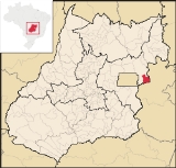
Cabeceiras State Goiás GoiásGoiás is a state of Brazil, located in the central part of the country. The name Goiás comes from the name of an indigenous community...Geographical coordinates: 15°47′45"S 46°55′37"W Area: 1,117.4 km² Population: 6,610 (IBGE 2005) Elevation: 926 m above sea level Postcode (CEP): 73870-000 IBGE statistical microregion: Entorno de Brasília Became a city: 1958 Mayor: Antônio de Almeida Nogueira Neto Distance to Goiânia Goiânia-Climate:The city has a tropical wet and dry climate with an average temperature of . There's a wet season, from October to April, and a dry one, from May to September. Annual rainfall is around 1,520 mm....
:344 km. Website: none
Town
A town is a human settlement larger than a village but smaller than a city. The size a settlement must be in order to be called a "town" varies considerably in different parts of the world, so that, for example, many American "small towns" seem to British people to be no more than villages, while...
and municipality
Municipality
A municipality is essentially an urban administrative division having corporate status and usually powers of self-government. It can also be used to mean the governing body of a municipality. A municipality is a general-purpose administrative subdivision, as opposed to a special-purpose district...
in east-central Goiás
Goiás
Goiás is a state of Brazil, located in the central part of the country. The name Goiás comes from the name of an indigenous community...
state, Brazil
Brazil
Brazil , officially the Federative Republic of Brazil , is the largest country in South America. It is the world's fifth largest country, both by geographical area and by population with over 192 million people...
. It is fast becoming a major producer of agricultural products using center pivot irrigation
Center pivot irrigation
Center-pivot irrigation , also called circle irrigation, is a method of crop irrigation in which equipment rotates around a pivot...
.
Location and Highway Connections
Cabeceiras is located directly east of BrasíliaBrasília
Brasília is the capital city of Brazil. The name is commonly spelled Brasilia in English. The city and its District are located in the Central-West region of the country, along a plateau known as Planalto Central. It has a population of about 2,557,000 as of the 2008 IBGE estimate, making it the...
and is 38 km. south of the important BR-020 highway.
The municipal boundaries are with:
- North and West: FormosaFormosa, GoiásFormosa is a city and municipality located in the state of Goiás, Brazil, approximately 80 kilometers east of Brasília. The population was 90,247 in a total area of 5,806.89 km² . Formosa is known for its waterfalls and natural beauty...
- South and East: BuritisBuritisBuritis is a small city and municipality in northern Minas Gerais state, Brazil. It is located just south of the Urucuia River, which is a tributary of the São Francisco River.-Highway connections:...
, UnaíUnaíUnaí is a city and municipality in northern Minas Gerais state, Brazil, postal code 38610-000.-Location:Unaí is located southeast of Brasília and the Federal District and is linked to that important urban nucleus by highway BR 251, which also connects with BR 040 at Paracatu...
and Cabeceira GrandeCabeceira GrandeCabeceira Grande is a municipality in northern part of the Brazilian state of Minas Gerais. It is located just south of the boundary with the Federal District and the national capital Brasília. The population was 6,294 in a total area of 1,026 km²...
, all being in Minas GeraisMinas GeraisMinas Gerais is one of the 26 states of Brazil, of which it is the second most populous, the third richest, and the fourth largest in area. Minas Gerais is the Brazilian state with the largest number of Presidents of Brazil, the current one, Dilma Rousseff, being one of them. The capital is the...
.
The distance to the state capital, Goiânia
Goiânia
-Climate:The city has a tropical wet and dry climate with an average temperature of . There's a wet season, from October to April, and a dry one, from May to September. Annual rainfall is around 1,520 mm....
, is 344 km. Highway connections are made from Goiânia
Goiânia
-Climate:The city has a tropical wet and dry climate with an average temperature of . There's a wet season, from October to April, and a dry one, from May to September. Annual rainfall is around 1,520 mm....
by BR-153 / Anápolis
Anápolis
Anápolis is the third largest city in the State of Goiás in Brazil. It lies in the center of a rich agricultural region and has become a leader in food processing and pharmaceutical plants.-Location and population:...
/ Alexânia
Alexânia
Alexânia is a small town and municipality in central Goiás state, Brazil. Alexânia is known for its alleged extraterrestrial sightings in the late sixties and early seventies. The Areias River passes through the municipality.-Location:...
/ BR-060 / Planaltina
Planaltina
Planaltina is one of the administrative districts of the Federal District of Brazil, with an area of 1,534 kmª and a population of 147,114 in 2000, of whom 134,663 were classified as urban and 12,451 as rural...
(DF) / Formosa
Formosa, Goiás
Formosa is a city and municipality located in the state of Goiás, Brazil, approximately 80 kilometers east of Brasília. The population was 90,247 in a total area of 5,806.89 km² . Formosa is known for its waterfalls and natural beauty...
/ BR-020 / BR-030 / GO-34.
The most important rivers and streams in its territory are the Bezerra, Urucuia, Ribeirão Taboca, Ribeirão da Morte, Córregos Fundo, Cachoeira, Capoeira, Roncador and Salobro; and the lakes of Mato Grande, Roncador, Moirões, Formosa, Penha and Prata.
Districts, Villages, and Hamlets
- Hamlets: Cabeceira da Mata, Lagoa do Mato Grande and Olaria.
Demographics
- Population density: 5.86 inhab/km² (2007)
- Population in 1980: 4,993
- Population in 2007: 6,610
- Urban Population in 2007: 5,261
- Rural Population: 1,349
- Population growth rate: 0.93% 1996/2007
The economy
Once a poor area dependent on subsistence farming and extensive but poorly managed cattle raising, the municipality concentrates the base of its economy on agriculture, which is now one of the most dynamic in the state. With a large number of farmers from the south of the country, especially Rio Grande do SulRio Grande do Sul
Rio Grande do Sul is the southernmost state in Brazil, and the state with the fifth highest Human Development Index in the country. In this state is located the southernmost city in the country, Chuí, on the border with Uruguay. In the region of Bento Gonçalves and Caxias do Sul, the largest wine...
, agriculture is characterized by use of technology for planting and preparation of the soil, which has given it a high productivity. There is great production of irrigated corn (8,300 hectares), soybeans (32,000 hectares), beans, sorghum, and even wheat.
Motor vehicles
- Automobiles: 534
- Pickup trucks: 76
- Number of inhabitants per motor vehicle: 10.8
Agricultural data 2006
- Farms: 328
- Total area: 80,030 ha.
- Area of permanent crops: 648 ha.
- Area of perennial crops: 26,168 ha. (soybeans, corn, sorghum)
- Area of pasture: 37.371 ha.
- Area of woodland and forests: 14.616 ha.
- Cattle herd: 27,983
Health and education
- Infant mortality in 2000: 33.49
- Hospitals: 01 with 14 beds (2007)
- Literacy rate in 2000: 84.2
- Higher education: none (2007)
- Human Development IndexHuman Development IndexThe Human Development Index is a composite statistic used to rank countries by level of "human development" and separate "very high human development", "high human development", "medium human development", and "low human development" countries...
: 0.695 - State ranking: 213 (out of 242 municipalities)
- National ranking: 3068 (out of 5507 municipalities)
History
Cabeceiras began in 1942 with the construction of a house by Antônio Ribeiro de Andrade, nicknamed "o Bahiano", who in turn built a chapel honoring Santa Rosa de Lima, along the banks of a stream called Taboquinha. New families arrived and the name of Cabeceiras was given due to its location near the source (cabeceiras) of the stream. In 1952 the village (povoado) was elevated to the status of district (distrito). In 1958 it was dismembered from the municipality of FormosaFormosa
Formosa or Ilha Formosa is a Portuguese historical name for Taiwan , literally meaning, "Beautiful Island". The term may also refer to:-Places:* Formosa Strait, another name for the Taiwan Strait...
.