

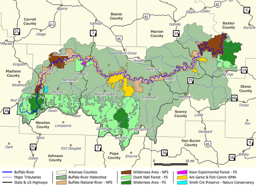
Buffalo National River
Encyclopedia
Arkansas
Arkansas is a state located in the southern region of the United States. Its name is an Algonquian name of the Quapaw Indians. Arkansas shares borders with six states , and its eastern border is largely defined by the Mississippi River...
, was the first National River to be designated in the United States
United States
The United States of America is a federal constitutional republic comprising fifty states and a federal district...
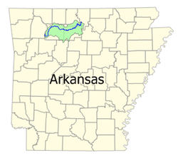
. The Buffalo River is slightly more than 150 miles (241.4 km) in length, with the lower 135 miles (217.3 km) flowing within the boundaries of an area managed by the National Park Service
National Park Service
The National Park Service is the U.S. federal agency that manages all national parks, many national monuments, and other conservation and historical properties with various title designations...
, where it is designated the Buffalo National River. The river flows through Newton
Newton County, Arkansas
Newton County is a county located in the U.S. state of Arkansas. As of 2010, the population is 8,330. The county seat is Jasper. Newton County is Arkansas's 46th county, formed on December 14, 1842, and named for Thomas W. Newton, an Arkansas Congressman...
, Searcy, Marion, and Baxter
Baxter County, Arkansas
Baxter County is a county located in the U.S. state of Arkansas. It is in the northern part of the state, and shares a border with Missouri. It is commonly referred to as the Twin Lakes Area because it is bordered by two of Arkansas' largest lakes, Bull Shoals Lake and Norfork Lake...
Counties, from west to east. The river originates in the highest part of Boston Mountains
Boston Mountains
The Boston Mountains area is a high and deeply dissected plateau located in northern Arkansas and eastern Oklahoma. The Oklahoma portion of the range is locally referred to as the Cookson Hills. The rocks of the region are essentially little disturbed, flat-lying sedimentary layers of the Paleozoic...
of the Ozarks, flows out onto the Springfield Plateau near the historic community of Erbie, and finally crosses the Salem Plateau just before joining the White River
White River (Arkansas)
The White River is a 722-mile long river that flows through the U.S. states of Arkansas and Missouri.-Course:The source of the White River is in the Boston Mountains of northwest Arkansas, in the Ozark-St. Francis National Forest southeast of Fayetteville...
. The Park is home to the state's only elk
Elk
The Elk is the large deer, also called Cervus canadensis or wapiti, of North America and eastern Asia.Elk may also refer to:Other antlered mammals:...
herd. The upper section of the river in the Ozark National Forest is managed by the U.S. Forest Service and is designated as a National Scenic River and a National Wild River
National Wild and Scenic River
National Wild and Scenic River is a designation for certain protected areas in the United States.The National Wild and Scenic Rivers Act was an outgrowth of the recommendations of a Presidential commission, the Outdoor Recreation Resources Review Commission...
.
The Buffalo National River was established by an Act of Congress
Act of Congress
An Act of Congress is a statute enacted by government with a legislature named "Congress," such as the United States Congress or the Congress of the Philippines....
on March 1, 1972, ending the recurring plans of the U.S. Army Corps of Engineers to construct one or more dams on the river. The National River designation protects natural rivers from industrial uses, impoundments and other obstructions that may change the natural character of the river or disrupt the natural habitat for the flora and fauna that live in or near the river.
At a point about 15 miles (24.1 km) above the Park boundary in Newton County, Arkansas
Newton County, Arkansas
Newton County is a county located in the U.S. state of Arkansas. As of 2010, the population is 8,330. The county seat is Jasper. Newton County is Arkansas's 46th county, formed on December 14, 1842, and named for Thomas W. Newton, an Arkansas Congressman...
, the Buffalo River begins as the Main Prong of Big Buffalo Creek. On 1:24,000 scale United States Geological Survey
United States Geological Survey
The United States Geological Survey is a scientific agency of the United States government. The scientists of the USGS study the landscape of the United States, its natural resources, and the natural hazards that threaten it. The organization has four major science disciplines, concerning biology,...
topographic maps, the Buffalo River is shown to form at the confluence of Reeves Fork and Big Buffalo Creek north of Fallsville, Arkansas. The river flows north through Boxley to Ponca, where it then begins an eastward trek across northern Arkansas to its confluence with the White River
White River (Arkansas)
The White River is a 722-mile long river that flows through the U.S. states of Arkansas and Missouri.-Course:The source of the White River is in the Boston Mountains of northwest Arkansas, in the Ozark-St. Francis National Forest southeast of Fayetteville...
on the Marion-Baxter County line. Advanced canoeists and kayakers often refer to the 15 miles (24.1 km) section upriver from Boxley, Arkansas as the Hailstone River. This extremely challenging section of the river is floatable only during periods of high water and should be attempted only by those with solid whitewater skills.
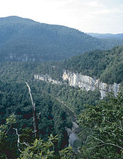
Along the upper river, the gradient is steep and the water is fast, leveling and slowing as the river runs its course. The upper section has most of the whitewater rapids to be found along the river, and features dramatic topography including sink holes and cave
Cave
A cave or cavern is a natural underground space large enough for a human to enter. The term applies to natural cavities some part of which is in total darkness. The word cave also includes smaller spaces like rock shelters, sea caves, and grottos.Speleology is the science of exploration and study...
s, springs
Spring (hydrosphere)
A spring—also known as a rising or resurgence—is a component of the hydrosphere. Specifically, it is any natural situation where water flows to the surface of the earth from underground...
, and waterfall
Waterfall
A waterfall is a place where flowing water rapidly drops in elevation as it flows over a steep region or a cliff.-Formation:Waterfalls are commonly formed when a river is young. At these times the channel is often narrow and deep. When the river courses over resistant bedrock, erosion happens...
s, over 500 feet (152.4 m) tall sandstone
Sandstone
Sandstone is a sedimentary rock composed mainly of sand-sized minerals or rock grains.Most sandstone is composed of quartz and/or feldspar because these are the most common minerals in the Earth's crust. Like sand, sandstone may be any colour, but the most common colours are tan, brown, yellow,...
and limestone
Limestone
Limestone is a sedimentary rock composed largely of the minerals calcite and aragonite, which are different crystal forms of calcium carbonate . Many limestones are composed from skeletal fragments of marine organisms such as coral or foraminifera....
bluffs, and many interesting rock
Rock (geology)
In geology, rock or stone is a naturally occurring solid aggregate of minerals and/or mineraloids.The Earth's outer solid layer, the lithosphere, is made of rock. In general rocks are of three types, namely, igneous, sedimentary, and metamorphic...
formations. At one point, a 0.65 miles (1 km) hike from the river up a narrow, boxed canyon leads to a 209 feet (63.7 m) waterfall, Hemmed-In-Hollow Falls
Hemmed-In-Hollow Falls
Hemmed-In-Hollow Falls is a single drop waterfall located within the Ponca Wilderness Area of the Buffalo National River in northern Arkansas. The height of the falls is 209 feet...
, the highest of its kind between the Southern Appalachians and the Rockies
Rocky Mountains
The Rocky Mountains are a major mountain range in western North America. The Rocky Mountains stretch more than from the northernmost part of British Columbia, in western Canada, to New Mexico, in the southwestern United States...
. The river's ancient current also gives life to well over 300 species of fish
Fish
Fish are a paraphyletic group of organisms that consist of all gill-bearing aquatic vertebrate animals that lack limbs with digits. Included in this definition are the living hagfish, lampreys, and cartilaginous and bony fish, as well as various extinct related groups...
, insect
Insect
Insects are a class of living creatures within the arthropods that have a chitinous exoskeleton, a three-part body , three pairs of jointed legs, compound eyes, and two antennae...
s, freshwater mussel
Mussel
The common name mussel is used for members of several families of clams or bivalvia mollusca, from saltwater and freshwater habitats. These groups have in common a shell whose outline is elongated and asymmetrical compared with other edible clams, which are often more or less rounded or oval.The...
s, and aquatic plant
Plant
Plants are living organisms belonging to the kingdom Plantae. Precise definitions of the kingdom vary, but as the term is used here, plants include familiar organisms such as trees, flowers, herbs, bushes, grasses, vines, ferns, mosses, and green algae. The group is also called green plants or...
s.
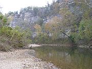
The Buffalo National River is a popular camping, canoeing
Canoeing
Canoeing is an outdoor activity that involves a special kind of canoe.Open canoes may be 'poled' , sailed, 'lined and tracked' or even 'gunnel-bobbed'....
, and fishing
Fishing
Fishing is the activity of trying to catch wild fish. Fish are normally caught in the wild. Techniques for catching fish include hand gathering, spearing, netting, angling and trapping....
destination. Visitors may bring their own canoes or rent from several independent concessioners. Camping is generally allowed throughout the park with the following exceptions: the Hemmed-in-Hollow area, on Big Bluff, in historical structures, on private property within the park, or within 100 feet (30.5 m) of any trail or watercourse. Camping is, however, permitted on gravel bars and sand bars along the river. In addition, the National Park Service has a number of "developed" campgrounds along the river.
The National Park Service headquarters for the Buffalo National River is located in Harrison, Arkansas
Harrison, Arkansas
Harrison is a city in Boone County, Arkansas, United States. It is the county seat. According to 2007 Census Bureau estimates, the population of the city was 13,108. Boone County was organized in 1869, during reconstruction after the civil war. Harrison was platted and made the county seat. It is...
.
Major access areas
- Boxley Bridge – located on the upper end of the river along Arkansas 21. Boxley provides access to the Upper Buffalo Wilderness Area, a joint area with the Ozark National Forest and the National Riverway. Provides river access
- Lost Valley - located on Arkansas 43 between Arkansas 21 and Ponca.
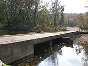
- Ponca – Location of Beaver Jim Villines Boyhood Home. Ponca retains one of the old ‘low water’ bridges over the Buffalo. All boaters must portage over this barrier. Provides river access
- Steel Creek – is located on the upstream side of the Ponca Wilderness Area. Provides river access
- Kyles Landing – is located on the downstream side and across the river from the Ponca Wilderness area. Provides river access
- Erbie - Provides river access
- Ozark - Provides river access
- Pruitt Ranger Station – is on Arkansas 7 at the top of the hill overlooking the picnic area and foot access to the river. For boat access, you need to cross the high bridge on Arkansas 7 and use Pruitt Landing.
- Pruitt Landing – is located just downstream from Pruitt Ranger Station. Provides river access
- Hasty – located on Arkansas 123, Hasty is the second ‘low water’ bridge along the river coming down stream. Provides river access
- Carver – located on the paved road between Hasty on Arkansas 123 and Piercetown on Arkansas 74. Provides river access
- Mount Hersey – is accessible from unimproved roads. From this access point, ‘Tha Nars’ (Narrows) and Skull Bluff are reached downstream. Provides river access
- Woolum - Provides river access
- Tyler Bend Visitor Center – is the primary public contact area. It’s just off of U.S. 65. There is a full service visitor center, picnic area, campground and ranger station. Provides river access Additionally, the ‘Colliers Homestead’ preserves a record of life in the mountains
- Grinders Ferry – is located at the Highway 65 Bridge over the Buffalo River. Provides river access
- Gilbert – is at the end of Arkansas 333 a short 4 miles (6.4 km) off U.S. 65. Provides river access
- Maumee North – is on the north side of the river and west of Maumee South. It is accessed by an unimproved road. Provides river access
- Maumee South – is on the south side of the river and is accessed from an unimproved road beyond the end of the pavement on County Road 49.
- Dillards Ferry – is located on Arkansas 14 at the bridge over the Buffalo River. Provides river access
- Buffalo Point Ranger Station – is at the end of the pavement on Arkansas 268. Provides river access
- Rushland – is reached by an unimproved road beyond the end of the pavement on County 26. It provides access across the river to the Lower Buffalo Wilderness Area a joint wild area with the Ozark National Forest’s Leatherwood Wilderness Area. Provides river access
- Buffalo City – is located outside the National River at the junction of the Buffalo River with its parent the White RiverWhite River (Arkansas)The White River is a 722-mile long river that flows through the U.S. states of Arkansas and Missouri.-Course:The source of the White River is in the Boston Mountains of northwest Arkansas, in the Ozark-St. Francis National Forest southeast of Fayetteville...
. Buffalo City is located off the US 62-412 in Mountain Home on State road 126 South, about 12 miles from Mountain Home. Provides river access, primarily as the last take out for the Buffalo River along with boat rentals, camping and cabins.
See also
- Buffalo River TrailBuffalo River TrailThe Buffalo River Trail is a hiking and backpacking trail that follows the path of the Buffalo National River in Arkansas. The trail is thirty-seven miles long, and runs from Boxley Valley, Arkansas to Pruitt, Arkansas....
- Buffalo River State Park Historic DistrictBuffalo River State Park (Arkansas)Buffalo River State Park was an Arkansas state park, established in 1938, that was absorbed into Buffalo National River when the Federal park was established in 1972. The area is now known as Buffalo Point...
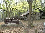
- Big Buffalo Valley Historic DistrictBig Buffalo Valley Historic DistrictThe Big Buffalo Valley Historic District, also known as the Boxley Valley Historic District, is notable as a cultural landscape in Buffalo National River. It comprises the Boxley Valley in northern Arkansas, near the town of Boxley. The valley includes a number of family-operated farms, primarily...
- Rush Historic DistrictRush Historic DistrictThe Rush Historic District is a zinc mining region of the Ozark Mountains in Arkansas. Now located within Buffalo National River, the district includes ruins dating from 1880 to 1940...
- Parker-Hickman Farm Historic DistrictParker-Hickman Farm Historic DistrictThe Parker-Hickman Farm includes the oldest standing log structure in Buffalo National River. The farm was homesteaded in the 1840's by settlers from Tennessee. It embodies an agricultural landscape with farmstead, extant fields , fencerows, roads, cattle gates, garden and orchard plots, wooded...
Further reading
- The Buffalo River in Black and White. University of Arkansas Press, 1998. ISBN 0-912456-21-3
- The Buffalo Flows: The Story of Our First National River. University of Arkansas Press, 2009.