

Buckskin Gulch
Encyclopedia
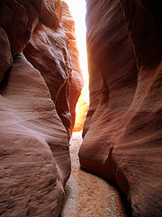
The Buckskin Gulch, a canyon
Canyon
A canyon or gorge is a deep ravine between cliffs often carved from the landscape by a river. Rivers have a natural tendency to reach a baseline elevation, which is the same elevation as the body of water it will eventually drain into. This forms a canyon. Most canyons were formed by a process of...
in southern Utah
Utah
Utah is a state in the Western United States. It was the 45th state to join the Union, on January 4, 1896. Approximately 80% of Utah's 2,763,885 people live along the Wasatch Front, centering on Salt Lake City. This leaves vast expanses of the state nearly uninhabited, making the population the...
, is one of the main tributaries of the Paria River
Paria River
The Paria River is a tributary of the Colorado River, approximately long, in southern Utah and northern Arizona in the United States. It drains a rugged and arid region northwest of the Colorado, flowing through roadless slot canyons along part of its course....
, which is itself a minor tributary
Tributary
A tributary or affluent is a stream or river that flows into a main stem river or a lake. A tributary does not flow directly into a sea or ocean...
of the Colorado River. It is the longest and deepest slot canyon
Slot canyon
A slot canyon is a narrow canyon, formed by the wear of water rushing through rock. A slot canyon is significantly deeper than it is wide. Some slot canyons can measure less than one metre across at the top but drop more than 30 m to the floor of the canyon.Most slot canyons are formed in...
in the southwest United States
United States
The United States of America is a federal constitutional republic comprising fifty states and a federal district...
and may very well be the longest in the world. As such it is one of the premier destinations for slot canyon hikers, and receives a high amount of foot traffic.
At over 13 miles (20.9 km) in length it is often visited in conjunction with the longer Paria Canyon, although some prefer to make a long day trip out of the hike. With a distance of 20 miles (32.2 km), hiking this canyon in one day is possible but not easy. Wire Pass, a short tributary to the Buckskin, is an ideal alternative for a short day hike that still takes hikers through the narrow, curving features that are the hallmark of slot canyons.
Access
Buckskin Gulch is reached via US Highway 89 or U.S. Highway 89A, and is approximately half way between the towns of Kanab, UtahKanab, Utah
Kanab is a city in and the county seat of Kane County, Utah, United States. The area was first settled in 1864 and the town was founded in 1870 when ten Mormon families moved into the area. The population was 3,564 at the 2000 census...
and Page, Arizona
Page, Arizona
Page is a city in Coconino County, Arizona, United States, near the Glen Canyon Dam and Lake Powell. According to 2005 Census Bureau estimates, the population of the city is 6,794.-Geography:Page is located at ....
. There is a ranger station right near the bridge over the intermittently-flowing Paria River, and the dirt road to the Gulch is approximately 2 miles (3.2 km) west of the station. You then go 8.4 miles (13.5 km) down the dirt road to the jump-off point. The Wire Pass entrance shares the same trailhead
Trailhead
A trailhead is the point at which a trail begins, where the trail is often intended for hiking, biking, horseback riding, or off-road vehicles...
, Wire Pass Trailhead
Wire Pass Trailhead
Wire Pass Trailhead is the gateway to some spectacular scenery and hiking, including The Wave and Buckskin Gulch. The trailhead is located in the beautiful and rugged Paria Canyon-Vermilion Cliffs Wilderness Area of southern Utah and northern Arizona about halfway between Kanab, Utah and Page,...
, with the equally spectacular Coyote Buttes
Coyote Buttes
Coyote Buttes is a section of the Paria Canyon-Vermilion Cliffs Wilderness managed by the Bureau of Land Management , spanning extreme South Central Utah and North Central Arizona, just south of US 89 halfway between Kanab, Utah and Page, Arizona....
, home to The Wave
The Wave, Arizona
The Wave is a sandstone rock formation located in the United States of America near the Arizona and Utah border on the slopes of the Coyote Buttes, in the Paria Canyon-Vermilion Cliffs Wilderness, on the Colorado Plateau...
, a famous sandstone
Sandstone
Sandstone is a sedimentary rock composed mainly of sand-sized minerals or rock grains.Most sandstone is composed of quartz and/or feldspar because these are the most common minerals in the Earth's crust. Like sand, sandstone may be any colour, but the most common colours are tan, brown, yellow,...
rock formation.
Regulations
Permits are required by law for both day hiking and overnight backpacking in the Buckskin Gulch-Paria Canyon-Vermilion Cliffs Wilderness Area. Permits can be obtained from the Bureau of Land ManagementBureau of Land Management
The Bureau of Land Management is an agency within the United States Department of the Interior which administers America's public lands, totaling approximately , or one-eighth of the landmass of the country. The BLM also manages of subsurface mineral estate underlying federal, state and private...
office online. Only twenty overnight permits per day are allowed and group sizes are limited to ten persons. The overnight fee is $5.00 per person per day while day use permits are $6.00 per person per day. There is also a $5 fee per dog, per day. Due to the popularity of the canyon, permits typically sell out several months in advance. Campfires are prohibited and human waste cannot be buried and must be packed out in order to preserve the pristine condition of the area. Buckskin Gulch lies within the Grand Staircase-Escalante National Monument
Grand Staircase-Escalante National Monument
The Grand Staircase-Escalante National Monument contains 1.9 million acres of land in southern Utah, the United States. There are three main regions: the Grand Staircase, the Kaiparowits Plateau, and the Canyons of the Escalante. President Bill Clinton designated the area as a U.S. National...
and Paria Canyon-Vermilion Cliffs Wilderness Area
Paria Canyon-Vermilion Cliffs Wilderness
The Paria Canyon-Vermilion Cliffs Wilderness is a wilderness area located in northern Arizona and southern Utah, USA, within the arid Colorado Plateau region. The wilderness is composed of broad plateaus, tall escarpments, and deep canyons....
of the Bureau of Land Management
Bureau of Land Management
The Bureau of Land Management is an agency within the United States Department of the Interior which administers America's public lands, totaling approximately , or one-eighth of the landmass of the country. The BLM also manages of subsurface mineral estate underlying federal, state and private...
.
Hazards
Wire Pass and Buckskin Gulch generally do not require rappelling equipment, but there may be a few pour-offs or the necessity to wade in ankle- to chest-high water and/or mud. Hiking Buckskin Gulch is extremely challenging. Be prepared with extra clothes to wear for warmth after wading through cold, stagnant pools of water, rather than depending on campfires, which are prohibited in this confined environment. Additionally, the lack of sun-light in the canyon can make it much colder than the surrounding exposed desert. At one point along the route, there is a 15 feet (4.6 m) drop-off that usually has rope, but it is a good idea to bring at least 30 feet (9.1 m) of rope to navigate some of the pour-offs. Also along the route, small areas of quicksandQuicksand
Quicksand is a colloid hydrogel consisting of fine granular matter , clay, and water.Water circulation underground can focus in an area with the optimal mixture of fine sands and other materials such as clay. The water moves up and then down slowly in a convection-like manner throughout a column...
can be found.
Slot canyons are particularly dangerous due to the risk of flash floods. Storms more than 50 miles (80.5 km) away can send 100 feet (30.5 m) walls of water down the narrow canyons and hikers have been killed in such events. Hikers should check conditions carefully and not rely on seeing the sky to judge the weather. If there is even a slight chance of rain, do not enter slot canyons.
External links
- Paria Canyon-Vermillion Cliffs Wilderness
- http://climb-utah.com/Escalante/buckskin.htm Buckskin Gulch at climb-Utah.com, a detailed description of the hike from Wire Pass, with GPS waypoints.
- Buckskin Gulch GPS map Buckskin Gulch at Wikiloc.com. See the trail on Google Maps and Google Earth.