

Brimley Road
Encyclopedia

Scarborough, Ontario
Scarborough is a dissolved municipality within the city of Toronto, Ontario, Canada. Geographically, it comprises the eastern part of Toronto. It is bordered on the south by Lake Ontario, on the west by Victoria Park Avenue, on the north by Steeles Avenue East, and on the east by the Rouge River...
and York Region, Ontario
Ontario
Ontario is a province of Canada, located in east-central Canada. It is Canada's most populous province and second largest in total area. It is home to the nation's most populous city, Toronto, and the nation's capital, Ottawa....
, Canada. The road carries 32000 vehicles daily as of May 2007 and is classified as a major arterial road
Arterial road
An arterial road, or arterial thoroughfare, is a high-capacity urban road. The primary function of an arterial road is to deliver traffic from collector roads to freeways, and between urban centres at the highest level of service possible. As such, many arteries are limited-access roads, or feature...
by the city of Toronto.
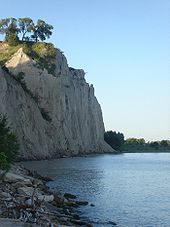
Beginning at Scarborough Bluffs
Scarborough Bluffs
The Scarborough Bluffs is an escarpment in Scarborough, Toronto, Ontario, Canada. Forming much of the eastern portion of Toronto's waterfront, it is located along the shoreline of Lake Ontario. At its highest point, the escarpment rises above its foot and spans a length of...
by Lake Ontario
Lake Ontario
Lake Ontario is one of the five Great Lakes of North America. It is bounded on the north and southwest by the Canadian province of Ontario, and on the south by the American state of New York. Ontario, Canada's most populous province, was named for the lake. In the Wyandot language, ontarío means...
, Brimley weaves through Scarborough, past Steeles Avenue
Steeles Avenue
Steeles Avenue is an east-west street that forms the northern city limit of Toronto and the southern limit of York Region, Ontario, Canada. It stretches across the western Greater Toronto Area from Milborough Townline in Halton Region east to the Scarborough-Pickering limit. It runs for within...
and ends at 14th Avenue in Markham
Markham, Ontario
Markham is a town in the Regional Municipality of York, located within the Greater Toronto Area of Southern Ontario, Canada. The population was 261,573 at the 2006 Canadian census...
. The Scarborough portion is mainly residential with small strip plaza
Strip mall
A strip mall is an open-area shopping center where the stores are arranged in a row, with a sidewalk in front. Strip malls are typically developed as a unit and have large parking lots in front...
s along the way. North of Finch Avenue
Finch Avenue
Finch Avenue is an arterial thoroughfare and concession road which travels east–west through the city of Toronto. The road also has short extensions into Peel and Durham Regions as Peel Regional Road 2 and Durham Regional Road 37.-History:...
is Brimley forest, a small patch of what the area once looked like. Past Steeles, Brimley weaves through the residential areas of the Milliken
Milliken, Ontario
Milliken or Milliken Mills is a neighbourhood in the city of Toronto and Markham, Ontario. It is located in the North East section of Scarborough and South East section of Markham...
community of Markham.
History
The corner of Brimley Road and Sheppard AvenueSheppard Avenue
Sheppard Avenue is an east-west principal arterial road in Toronto, Ontario, Canada. A small portion of a continuation of the road in Pickering, Ontario is also called Sheppard Avenue.-History:...
marks the central location around which the community of Agincourt was formed during the mid-19th century. The road has also come to border the neighbourhood Kennedy Park
Kennedy Park
Scarborough Junction is a neighbourhood in the Scarborough district of Toronto, Ontario, Canada. It is bordered by Birchmount Road, Brimley Road, Eglinton Avenue, and St. Clair Avenue.-History:...
and the electoral districts Scarborough—Agincourt
Scarborough—Agincourt
Scarborough—Agincourt is a federal electoral district in Toronto, Ontario, Canada that has been represented in the Canadian House of Commons since 1988.It covers the northwest of the Scarborough part of Toronto...
and Scarborough—Rouge River
Scarborough—Rouge River
Scarborough—Rouge River is a federal electoral district in Ontario, Canada, that has been represented in the Canadian House of Commons since 1988....
.
A museum off Brimley north of Lawrence Avenue East
Lawrence Avenue
Lawrence Avenue is a major east-west thoroughfare in Toronto, Ontario, Canada. It is divided into east and west portions by Yonge Street, the dividing line of east-west streets in Toronto....
in Thomson Park
Thomson Memorial Park
Thomson Memorial Park is a mid size park in Scarborough, Ontario, and is the site of the Scarborough Historical Museum and includes historical houses of the founding family of the former city, the Thomson's, from the 1790s; more Thomson houses are found on the northern edge of the park on St....
pays tribute to the founding family of the former Township of Scarborough; West Highland Creek
West Highland Creek
West Highland Creek is a river in Scarborough, part of Toronto, Ontario, Canada, a tributary of Highland Creek in the Lake Ontario drainage basin...
, a tributary of the Highland Creek, runs through the park.
401 overpass
The section south of Sheppard was once interrupted at Highway 401. An CA$Canadian dollar
The Canadian dollar is the currency of Canada. As of 2007, the Canadian dollar is the 7th most traded currency in the world. It is abbreviated with the dollar sign $, or C$ to distinguish it from other dollar-denominated currencies...
11 million overpass and partial interchange of the freeway was built and opened on October 18, 1987 over the objections of many area residents on concerns over increased traffic volume. In an attempt to address these concerns, it was initially restricted to transit buses and emergency vehicles. After a few months of widely-reported public pressure, Scarborough City Council voted February 18, 1988 to open the overpass to general traffic.
Cars on eastbound Highway 401 can directly exit onto southbound of Brimley Road but cars can also exit on to Progress Road that leads to the intersection of Brimley Road. Cars then could travel either northbound or southbound on to Brimley Road. No exit is provided for cars on westbound Highway 401. These westbound cars must use either the exits at Kennedy Road or McCowan Road to get to Brimley Road. Cars on Brimley Road northbound can use the onramp towards westbound Highway 401. No onramps are provided for northbound traffic onto eastbound Highway 401 and all southbound traffic on Brimley Road.
Public transit
The main Toronto Transit CommissionToronto Transit Commission
-Island Ferry:The ferry service to the Toronto Islands was operated by the TTC from 1927 until 1962, when it was transferred to the Metro Parks and Culture department. Since 1998, the ferry service is run by Toronto Parks and Recreation.-Gray Coach:...
bus route on Brimley Road is the 21 Brimley, which runs from Steeles Avenue
Steeles Avenue
Steeles Avenue is an east-west street that forms the northern city limit of Toronto and the southern limit of York Region, Ontario, Canada. It stretches across the western Greater Toronto Area from Milborough Townline in Halton Region east to the Scarborough-Pickering limit. It runs for within...
to Eglinton Avenue
Eglinton Avenue
Eglinton Avenue, originally known as the Richview Sideroad within Etobicoke, is an east-west arterial thoroughfare in Toronto and Mississauga, in the Canadian province of Ontario. Within Toronto, Eglinton Avenue is the only road which crosses through all six former boroughs...
, stopping on the way through the Scarborough Centre
Scarborough Centre (TTC)
Scarborough Centre is a station on the Scarborough RT line of the Toronto subway and RT. It is located north of Ellesmere Road between Brimley and McCowan Roads, just south of Highway 401...
RT station. At Eglinton, it turns west to the Kennedy
Kennedy (TTC)
Kennedy is the terminal subway station of the Bloor-Danforth and Scarborough RT lines of the Toronto subway and RT. It is located at 2455 Eglinton Avenue East, just east of Kennedy Road. The station opened in 1980 in what was then the Borough of Scarborough with the Bloor-Danforth platform, and the...
subway station. The old route of 128 Brimley North, which originally ran from Scarborough Centre to Steeles through McCowan Road and Sheppard Avenue
Sheppard Avenue
Sheppard Avenue is an east-west principal arterial road in Toronto, Ontario, Canada. A small portion of a continuation of the road in Pickering, Ontario is also called Sheppard Avenue.-History:...
, had started when the RT opened in 1985 and merged with the 21 in 1999. Prior to 1985, TTC service on Brimley north of Sheppard was served by a branch of the 57 Midland route.
The 131E Nugget Express runs on Brimley between Scarborough Centre and Eglinton during peak hours, stopping only at Lawrence Avenue
Lawrence Avenue
Lawrence Avenue is a major east-west thoroughfare in Toronto, Ontario, Canada. It is divided into east and west portions by Yonge Street, the dividing line of east-west streets in Toronto....
. The 12B Kingston Road serves Brimley from Kingston Road
Kingston Road (Toronto)
Kingston Road is the southernmost major road along the eastern portion of Toronto, specifically in the districts of East York and Scarborough. Until 1998, it formed a significant portion of Highway 2...
to Eglinton during peak hours as well. South of Kingston Road, Brimley Road South has served as the off-street loop for a number of routes since the 1950s, with the 12 Kingston Road doing this since 1968.
In 2002, the TTC examined the feasibility of building a Scarborough RT station at Brimley Road. It concluded that demands are not enough, and instead a pedestrian walkway was built towards Scarborough Centre
Scarborough Centre (TTC)
Scarborough Centre is a station on the Scarborough RT line of the Toronto subway and RT. It is located north of Ellesmere Road between Brimley and McCowan Roads, just south of Highway 401...
station. In 2007, it was stated that the issue will be re-examined when significant land developments take place west of Brimley Road near the proposed location of Brimley station. In February 2008 the TTC made a motion that the current study should include the addition of a station where the existing line crosses Brimley Road.
Landmarks
- Brimley Woods Park
- Chartwell Plaza
- Oriental Centre
- C.O. Bick Police College
- Scarborough Town CentreScarborough Town CentreThe Scarborough Town Centre is an upscale shopping mall in the Scarborough district of Toronto, Ontario, Canada. Central to the Scarborough City Centre, it is adjacent to the Scarborough Centre RT station and Scarborough Centre Bus Terminal. It was constructed by Oxford Properties and opened in...
- Bluffer's ParkScarborough BluffsThe Scarborough Bluffs is an escarpment in Scarborough, Toronto, Ontario, Canada. Forming much of the eastern portion of Toronto's waterfront, it is located along the shoreline of Lake Ontario. At its highest point, the escarpment rises above its foot and spans a length of...
- Thomson Memorial ParkThomson Memorial ParkThomson Memorial Park is a mid size park in Scarborough, Ontario, and is the site of the Scarborough Historical Museum and includes historical houses of the founding family of the former city, the Thomson's, from the 1790s; more Thomson houses are found on the northern edge of the park on St....
and Scarborough Memorial Museum - Historical Cemeteries
- Resthaven Memorial Gardens; west side between St Clair and Kingston Road.
- St Andrew's Cemetery, east of Brimley on St Andrew's Road.
- Ebenezer United (formerly Methodist) Church, northwest corner of Steeles and Brimley in Markham.
External links
- Brimley Road at Google MapsGoogle MapsGoogle Maps is a web mapping service application and technology provided by Google, free , that powers many map-based services, including the Google Maps website, Google Ride Finder, Google Transit, and maps embedded on third-party websites via the Google Maps API...