
Borah Peak
Encyclopedia
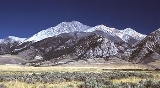
Borah Peak is the highest mountain in the U.S. state
of Idaho
. It is located in the central section of the Lost River Range
, within the Challis National Forest in eastern Custer County
. The peak is named for William Borah
(1865–1940), a prominent U.S. Senator
from Idaho (1907–40).
struck the Borah Peak area at 8:06 am MDT.
The earthquake lifted Borah Peak over 7 feet (2.13 m). The peak was scarred on the western side and, as of July 2010, the mark is still visible. Two children in Challis
were the only fatalities of the quake, struck by falling masonry while walking to elementary school.
just before the main summit crest. This point is known as Chickenout Ridge as many people will abort the attempt once they see the hazards up close. In the cooler seasons this dangerous crossing involves a traverse over snow, with steeply slanting slopes on either side. An ice axe
is strongly recommended for this section. Parties should turn back if there is any doubt about being able to make the crossing.
Borah Peak's north face is one of Idaho's only year-round snow climbs and provides a much greater challenge than the normal route. The face features a number of grade II class 5 routes on mixed terrain.
Three climbers have died on Borah Peak. Two climbers ascending the northwest ridge in 1977 were killed in an avalanche
. Another climber in 1987 lost his life on a glissade
during descent.

U.S. state
A U.S. state is any one of the 50 federated states of the United States of America that share sovereignty with the federal government. Because of this shared sovereignty, an American is a citizen both of the federal entity and of his or her state of domicile. Four states use the official title of...
of Idaho
Idaho
Idaho is a state in the Rocky Mountain area of the United States. The state's largest city and capital is Boise. Residents are called "Idahoans". Idaho was admitted to the Union on July 3, 1890, as the 43rd state....
. It is located in the central section of the Lost River Range
Lost River Range
The Lost River Range is a group of high mountains located in central Idaho, in the northwestern United States. It runs southeast for approximately 75 miles from the Salmon River near the community of Challis to the Snake River Valley near Arco...
, within the Challis National Forest in eastern Custer County
Custer County, Idaho
Custer County is a rural mountain county located in the center of the U.S. state of Idaho. Established in 1881, it was named for the General Custer Mine, where gold was discovered five years earlier . The population was 4,342 at the 2000 census; it is estimated to have fallen to 4,166 by 2007...
. The peak is named for William Borah
William Edgar Borah
William Edgar Borah was a prominent Republican attorney and longtime United States Senator from Idaho noted for his oratorical skills and isolationist views. One of his nicknames later in life was "The Lion of Idaho."...
(1865–1940), a prominent U.S. Senator
United States Senate
The United States Senate is the upper house of the bicameral legislature of the United States, and together with the United States House of Representatives comprises the United States Congress. The composition and powers of the Senate are established in Article One of the U.S. Constitution. Each...
from Idaho (1907–40).
1983 earthquake
On Friday, October 28, 1983, a magnitude 7.3 earthquake1983 Borah Peak earthquake
The 1983 Borah Peak earthquake occurred on October 28, 1983, in the Lost River Range at Borah Peak in central Idaho, United States. The most significant earthquake recorded in the state, it occurred on a Friday morning at 8:06 am MDT. The earthquake was a magnitude 7.3, and 6.9 on the Richter scale...
struck the Borah Peak area at 8:06 am MDT.
The earthquake lifted Borah Peak over 7 feet (2.13 m). The peak was scarred on the western side and, as of July 2010, the mark is still visible. Two children in Challis
Challis, Idaho
Challis is a city in Custer County, Idaho, United States. The population was 909 at the 2000 census. The city is the county seat of Custer County.-History:...
were the only fatalities of the quake, struck by falling masonry while walking to elementary school.
Climbing
The normal route involves ascending 5,262 vertical feet (1604 m) from the trailhead to the summit in just over 3.5 miles (5.6 km). This route on the southwest ridge, the most popular route, is a strenuous hike for the most part until one reaches a Class 4 arêteArete (landform)
thumb|right|[[Clouds Rest]] in [[Yosemite National Park]] is an arete.An arête is a thin, almost knife-like, ridge of rock which is typically formed when two glaciers erode parallel U-shaped valleys. The arête is a thin ridge of rock that is left separating the two valleys...
just before the main summit crest. This point is known as Chickenout Ridge as many people will abort the attempt once they see the hazards up close. In the cooler seasons this dangerous crossing involves a traverse over snow, with steeply slanting slopes on either side. An ice axe
Ice axe
An ice axe, is a multi-purpose ice and snow tool used by mountaineers both in the ascent and descent of routes which involve frozen conditions. It can be held and employed in a number of different ways, depending on the terrain encountered...
is strongly recommended for this section. Parties should turn back if there is any doubt about being able to make the crossing.
Borah Peak's north face is one of Idaho's only year-round snow climbs and provides a much greater challenge than the normal route. The face features a number of grade II class 5 routes on mixed terrain.
Three climbers have died on Borah Peak. Two climbers ascending the northwest ridge in 1977 were killed in an avalanche
Avalanche
An avalanche is a sudden rapid flow of snow down a slope, occurring when either natural triggers or human activity causes a critical escalating transition from the slow equilibrium evolution of the snow pack. Typically occurring in mountainous terrain, an avalanche can mix air and water with the...
. Another climber in 1987 lost his life on a glissade
Glissade (climbing)
Glissading is the act of descending a steep snow- or scree-covered slope via a controlled slide on one's feet or buttocks. It is an alternative to other descent methods such as plunge stepping, and may be used to expedite a descent, or simply for the thrill....
during descent.
See also
- List of U.S. states by elevation
- Mountain peaks of North AmericaMountain peaks of North AmericaThis article comprises three sortable tables of major mountain peaks of greater North America.This article defines greater North America as the portion of the continental landmass of the Americas extending northward from Panama plus the islands surrounding that landmass...
- Mountain peaks of the Rocky MountainsMountain peaks of the Rocky MountainsThis article comprises three sortable tables of major mountain peaks of the Rocky Mountains of North America.Topographic elevation is the vertical distance above the reference geoid, a precise mathematical model of the Earth's sea level as an equipotential gravitational surface...
- Mountain peaks of the United StatesMountain peaks of the United StatesThis article comprises three sortable tables of the major mountain peaks of the United States of America.Topographic elevation is the vertical distance above the reference geoid, a precise mathematical model of the Earth's sea level as an equipotential gravitational surface...
- 1983 Borah Peak earthquake1983 Borah Peak earthquakeThe 1983 Borah Peak earthquake occurred on October 28, 1983, in the Lost River Range at Borah Peak in central Idaho, United States. The most significant earthquake recorded in the state, it occurred on a Friday morning at 8:06 am MDT. The earthquake was a magnitude 7.3, and 6.9 on the Richter scale...
External links
- Mount Borah Climbing Guide - photos of the normal route
- Borah Peak Trip Report