
Bohol Island
Encyclopedia
Bohol Island boʊˈhɔːl is the main island of Bohol Province in the Visayas
. It lies southeast from Cebu Island
across Cebu Strait
(in some references called Bohol Strait) and southwest from Leyte Island
, separated by the Camotes Sea
and Canigao Channel
. Bohol is also located north of Mindanao
with Bohol Sea
between them.
With a land area of 3269 km² and a coastline 261 km long, Bohol is the tenth largest island of the Philippines. The main island is surrounded by about 70 smaller islands, the largest of which are Panglao Island
facing Tagbilaran City
in the southwest and Lapining Island in the northeast.
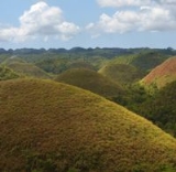
The Chocolate Hills
are considered one of Philippine's natural wonders and Bohol is often referred to as the Jewel of the Philippines. They are hills made of limestone leftover from coral reefs during the ice age when the island was submerged. They turn brown during the summer, hence their name.
Most beaches are of white sand. The sand is often of such high quality that it is exported to other beaches in the world. The most well known of these beaches are in Panglao Island
, and there, numerous islets have similar, yet untouched and pristine beaches.
There are four main rivers that run through Bohol with Loboc River
being the most famous for its river cruises, running from the center of the island to the southeastern coast. The largest, Inabanga River, runs in the northwestern part of the province. The Abatan River in the southwest, and Ipil river in the north.
Numerous waterfalls and caves are scattered across the island, including the beautiful Mag-Aso falls in Antequera. Mag-Aso means smoke in the native tongue. The water is cool and often creates a mist in humid mornings which can hide the falls.
 Location. Bohol is an island province in the Visayas
. It lies southeast from Cebu
across Bohol Strait and southwest from Leyte, separated by the Camotes Sea
and Canigao Channel
. Bohol is also located north of Mindanao
with Bohol Sea
between them.
Features. With a land area of 3269 km² and a coastline 261 km long, Bohol is the tenth largest island of the Philippines. The main island is surrounded by about 70 smaller islands, the largest of which are Panglao Island
facing Tagbilaran City
in the southwest and Lapinig Island in the northeast.
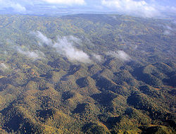
The terrain of Bohol is basically rolling and hilly and about half the island is covered in limestone
. Near the outer areas of the island are low mountain ranges. The interior is a large plateau
with irregular landforms.
Near Carmen
can be found the major tourist draw of the province, the Chocolate Hills. The more than 1,200 uniformly cone-shaped limestone hills were named that way because in the summer, the grass growing on the hills turn brown, making the landscape look like it had chocolate mounds all over. The Chocolate Hills is found on the provincial seal of Bohol.
and the northern part of Visayas
, Bohol is mostly unaffected by the numerous typhoons that hit the country. The weather is mostly mild all year round. When typhoons do hit the island, they usually cross quickly and are no longer powerful, their energy dissipated by the mountains in Leyte and Samar.
From November to April, the northeast monsoon (amihan
) prevails. Except for a rare shower, this is the mildest time of the year. Daytime temperatures average 28°C, cooling down at night to around 25°C. The summer season from May to July brings higher temperatures and very humid days. From August to October is the southwest monsoon (habagat). The weather during this season is not very predictable, with weeks of calm weather alternating with rainy days. It can rain any day of the year, but you wil have more chance for a heavy shower from November to January. If you want to see the Chocolate Hills in their "Chocolate" color, you will have to go there during the "Summer".
Visayas
The Visayas or Visayan Islands and locally known as Kabisay-an gid, is one of the three principal geographical divisions of the Philippines, along with Mindanao and Luzon. It consists of several islands, primarily surrounding the Visayan Sea, although the Visayas are considered the northeast...
. It lies southeast from Cebu Island
Cebu Island
Cebu is an island of the Philippines. It is the main island of Cebu Province at the center of the Visayan Islands, south of Manila.It lies to the east of Negros Island; to the east is Leyte and to the southeast is Bohol Island. It is flanked on both sides by the Cebu Strait and Tañon Strait...
across Cebu Strait
Cebu Strait
Cebu Strait, sometimes called Bohol Strait, is a strait in the Philippines that separates the island provinces of Cebu and Bohol. The Cebu Strait connects the western part of Bohol Sea with Camotes Sea, and is a major sea-lane connecting Cebu City on its northern end with port cities in the south...
(in some references called Bohol Strait) and southwest from Leyte Island
Leyte Island
Leyte is an island in the Visayas group of the Philippines.The island measures about 180 km north-south and about 65 km at its widest point. In the north it nearly joins Samar, separated by the San Juanico Strait, which becomes as narrow as 2 km in some places...
, separated by the Camotes Sea
Camotes Sea
The Camotes Sea is a small sea within the Philippine archipelago, between the Eastern Visayas and the Central Visayas. It is bordered by the islands of Leyte to the north and east, Bohol to the south, and Cebu to the west. The sea is connected to the Visayan Sea to the northwest, and to the Bohol...
and Canigao Channel
Canigao Channel
Canigao Channel is a body of water in the Philippines that connects the Bohol Sea with the Camotes Sea. It lies between Bohol Island and Leyte Island....
. Bohol is also located north of Mindanao
Mindanao
Mindanao is the second largest and easternmost island in the Philippines. It is also the name of one of the three island groups in the country, which consists of the island of Mindanao and smaller surrounding islands. The other two are Luzon and the Visayas. The island of Mindanao is called The...
with Bohol Sea
Bohol Sea
The Bohol Sea, also called the Mindanao Sea, is located between Visayas and Mindanao in the Philippines. It lies south of Bohol and Leyte and north of Mindanao...
between them.
With a land area of 3269 km² and a coastline 261 km long, Bohol is the tenth largest island of the Philippines. The main island is surrounded by about 70 smaller islands, the largest of which are Panglao Island
Panglao Island
Panglao is an island in the Philippines located in the Central Visayas, with an area of 80.5 sq. kilometers. Politically, it is divided into two municipalities: Dauis and Panglao, part of Bohol Province...
facing Tagbilaran City
Tagbilaran City
Tagbilaran City is a 2nd class component city in the island province of Bohol, Philippines and serves as its capital. Tagbilaran lies on the southwestern part of the province, and has a total land area of 32.7 km², with about 13 km of coastline...
in the southwest and Lapining Island in the northeast.
Geography
The Island of Bohol is oval-shaped mainland surrounded with 73 smaller islands, having a gently rolling terrain, ideal for commercial and industrial site development. Bohol's mountainous interior is home to rare and endangered flora and fauna. At certain points, hills drop steeply to the coast from a maximum elevation of 870 meters above sea level. The interior uplands are fit for agro-forestry and high value agricultural production. The central and northern lowlands have also fertile grounds and abundant water supply. Over a hundred caves have been identified, the biggest of which is found in the eastern part which makes Bohol ideal for spelunking adventures.The Chocolate Hills
Chocolate Hills
The Chocolate Hills is an unusual geological formation in Bohol province, Philippines. According to the latest accurate survey done, there are 1,776 hills spread over an area of more than . They are covered in green grass that turns brown during the dry season, hence the name.The Chocolate Hills...
are considered one of Philippine's natural wonders and Bohol is often referred to as the Jewel of the Philippines. They are hills made of limestone leftover from coral reefs during the ice age when the island was submerged. They turn brown during the summer, hence their name.
Most beaches are of white sand. The sand is often of such high quality that it is exported to other beaches in the world. The most well known of these beaches are in Panglao Island
Panglao Island
Panglao is an island in the Philippines located in the Central Visayas, with an area of 80.5 sq. kilometers. Politically, it is divided into two municipalities: Dauis and Panglao, part of Bohol Province...
, and there, numerous islets have similar, yet untouched and pristine beaches.
There are four main rivers that run through Bohol with Loboc River
Loboc River
The Loboc River is a river on Bohol Island, the Philippines. It is one of the major tourist destinations of Bohol, local and foreigners alike. The winding river plays host to cruises on board of small bancas or floating restaurants...
being the most famous for its river cruises, running from the center of the island to the southeastern coast. The largest, Inabanga River, runs in the northwestern part of the province. The Abatan River in the southwest, and Ipil river in the north.
Numerous waterfalls and caves are scattered across the island, including the beautiful Mag-Aso falls in Antequera. Mag-Aso means smoke in the native tongue. The water is cool and often creates a mist in humid mornings which can hide the falls.
Physical
Visayas
The Visayas or Visayan Islands and locally known as Kabisay-an gid, is one of the three principal geographical divisions of the Philippines, along with Mindanao and Luzon. It consists of several islands, primarily surrounding the Visayan Sea, although the Visayas are considered the northeast...
. It lies southeast from Cebu
Cebu Island
Cebu is an island of the Philippines. It is the main island of Cebu Province at the center of the Visayan Islands, south of Manila.It lies to the east of Negros Island; to the east is Leyte and to the southeast is Bohol Island. It is flanked on both sides by the Cebu Strait and Tañon Strait...
across Bohol Strait and southwest from Leyte, separated by the Camotes Sea
Camotes Sea
The Camotes Sea is a small sea within the Philippine archipelago, between the Eastern Visayas and the Central Visayas. It is bordered by the islands of Leyte to the north and east, Bohol to the south, and Cebu to the west. The sea is connected to the Visayan Sea to the northwest, and to the Bohol...
and Canigao Channel
Canigao Channel
Canigao Channel is a body of water in the Philippines that connects the Bohol Sea with the Camotes Sea. It lies between Bohol Island and Leyte Island....
. Bohol is also located north of Mindanao
Mindanao
Mindanao is the second largest and easternmost island in the Philippines. It is also the name of one of the three island groups in the country, which consists of the island of Mindanao and smaller surrounding islands. The other two are Luzon and the Visayas. The island of Mindanao is called The...
with Bohol Sea
Bohol Sea
The Bohol Sea, also called the Mindanao Sea, is located between Visayas and Mindanao in the Philippines. It lies south of Bohol and Leyte and north of Mindanao...
between them.
Features. With a land area of 3269 km² and a coastline 261 km long, Bohol is the tenth largest island of the Philippines. The main island is surrounded by about 70 smaller islands, the largest of which are Panglao Island
Panglao Island
Panglao is an island in the Philippines located in the Central Visayas, with an area of 80.5 sq. kilometers. Politically, it is divided into two municipalities: Dauis and Panglao, part of Bohol Province...
facing Tagbilaran City
Tagbilaran City
Tagbilaran City is a 2nd class component city in the island province of Bohol, Philippines and serves as its capital. Tagbilaran lies on the southwestern part of the province, and has a total land area of 32.7 km², with about 13 km of coastline...
in the southwest and Lapinig Island in the northeast.
The terrain of Bohol is basically rolling and hilly and about half the island is covered in limestone
Limestone
Limestone is a sedimentary rock composed largely of the minerals calcite and aragonite, which are different crystal forms of calcium carbonate . Many limestones are composed from skeletal fragments of marine organisms such as coral or foraminifera....
. Near the outer areas of the island are low mountain ranges. The interior is a large plateau
Plateau
In geology and earth science, a plateau , also called a high plain or tableland, is an area of highland, usually consisting of relatively flat terrain. A highly eroded plateau is called a dissected plateau...
with irregular landforms.
Near Carmen
Carmen, Bohol
Carmen is a 2nd class municipality located in the heart of the province of Bohol, Philippines. It is composed of 29 barangays with an area of 23,245 sq. kilometers. It was founded in the year 1869. According to the 2007 census, it has a population of 43,153 people.The Chocolate Hills is the main...
can be found the major tourist draw of the province, the Chocolate Hills. The more than 1,200 uniformly cone-shaped limestone hills were named that way because in the summer, the grass growing on the hills turn brown, making the landscape look like it had chocolate mounds all over. The Chocolate Hills is found on the provincial seal of Bohol.
Climate
Unlike LuzonLuzon
Luzon is the largest island in the Philippines. It is located in the northernmost region of the archipelago, and is also the name for one of the three primary island groups in the country centered on the Island of Luzon...
and the northern part of Visayas
Visayas
The Visayas or Visayan Islands and locally known as Kabisay-an gid, is one of the three principal geographical divisions of the Philippines, along with Mindanao and Luzon. It consists of several islands, primarily surrounding the Visayan Sea, although the Visayas are considered the northeast...
, Bohol is mostly unaffected by the numerous typhoons that hit the country. The weather is mostly mild all year round. When typhoons do hit the island, they usually cross quickly and are no longer powerful, their energy dissipated by the mountains in Leyte and Samar.
From November to April, the northeast monsoon (amihan
Amihan
Amihan is a bird in the Philippine mythology. According to the Tagalog folklore, Amihan is the first creature to inhabit the universe, along with the gods called Bathala and Aman Sinaya. In the legend Amihan is described as a bird who saves the first human beings, Malakas and Maganda from a bamboo...
) prevails. Except for a rare shower, this is the mildest time of the year. Daytime temperatures average 28°C, cooling down at night to around 25°C. The summer season from May to July brings higher temperatures and very humid days. From August to October is the southwest monsoon (habagat). The weather during this season is not very predictable, with weeks of calm weather alternating with rainy days. It can rain any day of the year, but you wil have more chance for a heavy shower from November to January. If you want to see the Chocolate Hills in their "Chocolate" color, you will have to go there during the "Summer".