

Blue Mountains
Encyclopedia
The Blue Mountains is a mountainous region in New South Wales
, Australia
. It borders on Sydney
's metropolitan area, its foothills starting approximately 50 kilometres west of the state capital
. The area begins on the west side of the Nepean River
and extends westward as far as Coxs River. Geologically, it is situated in the central parts of the Sydney basin
.
Consisting mainly of a sandstone plateau
, the area is dissected by gorges up to 760 metres deep. The highest point of the range is Mount Werong at 1,215 metres above sea level
. A large part of the Blue Mountains is incorporated into the Greater Blue Mountains Area
World Heritage Site
, consisting of seven national park areas and a conservation reserve.
The Blue Mountains area includes the local government areas of the City of Blue Mountains
, the City of Hawkesbury
, the City of Lithgow
and Oberon
.
The Gundungurra creation story of the Blue Mountains tells that Dreamtime creatures Mirigan and Garangatch, half fish and half reptile, fought an epic battle which scarred the landscape into the Jamison Valley.
The Gundungurra Tribal Council is a not for profit organisation representing the Gundungurra traditional owners, promoting heritage and culture and providing a support for Gundungurra people connecting back to Country. The Gundungurra web site in the links section below has a virtual video tour of the Upper Blue Mountains.
Gundungurra Tribal Council Aboriginal Corporation has a registered Native Title Claim since 1995 over their traditional lands, which include the Blue Mountains and surrounding areas.
Examples of Aboriginal habitation can be found in many places. In the Red Hands Cave, a rock shelter near Glenbrook
, the walls contain hand stencils from adults and children. On the southern side of Queen Elizabeth Drive, at Wentworth Falls
, a rocky knoll has a large number of grinding grooves created by rubbing stone implements on the rock to shape and sharpen them. There are also carved images of animal tracks and an occupation cave. The site is known as Kings Tableland Aboriginal Site and dates back 22,000 years.
, the first governor of New South Wales, first glimpsed the extent of the Blue Mountains from a ridge at the site of today's Oakhill College, Castle Hill. He named them the Carmarthen Hills, 'some forty to sixty miles distant..." and he reckoned that the ground was "most suitable for government stock". This is the location where Gidley King in 1799 established a prison town for political prisoners from Ireland
and Scotland
. The same view that Arthur Phillip enjoyed in his day can be enjoyed today.
The native Aborigines knew two routes across the mountains: Bilpin Ridge, which is now the location of Bells Line of Road between Richmond
and Bell
, and the Coxs River, a tributary of the Nepean River. It could be followed upstream to the open plains of the Kanimbla Valley, the type of country that farmers prize.
European settlers initially considered that fertile lands lay beyond the mountains, as was China in the belief of many convicts, but that this didn't matter much, since the mountains were impassable. This idea was, to some extent, convenient for local authorities. An "insurmountable" barrier would deter convicts from trying to escape in that direction.
A former convict, John Wilson, may have been the first European to cross the Blue Mountains. It is also believed that Mathew Everingham, 1795, may have also been partly successful based on letters he wrote at the time which came to light in the late 1980s. Wilson arrived with the First Fleet in 1788 and was freed in 1792. He settled in the bush, living with the Aborigines and even functioning as an intermediary between them and the settlers. In 1797 he returned to Sydney, claiming to have explored up to a hundred miles in all directions around Sydney, including across the mountains. His descriptions and observations were generally accurate, and it is possible that he had crossed the mountains via the southern aspect at the Coxs River corridor, guided by the Aborigines.
Governor Hunter was impressed by Wilson's skills and sent him on an expedition with John Price and others in January 1798. The party crossed the Nepean River and moved southwest towards the present site of Mittagong. There they turned west and found a route along the ridge where today the Wombeyan Caves Road is located. In the process they found a way to go west of the mountains, by going around them instead of across them. In March of the same year, Wilson and Price ventured to the Camden area, and then continued further south until they discovered Thirlmere Lakes, finally almost reaching the present site of Goulburn.
It is possible that the accomplishments of this expedition were suppressed by Hunter, who may not have wanted convicts to know that there was a relatively easy way out of Sydney. Wilson was killed by Aborigines after abducting one of their women for his personal use, but he had accomplished much as an explorer. He was never recognised as the first person to cross the mountains, possibly because his Coxs River journey could not be verified, while his route west of Mittagong may have been the "long way around" for a colony that had its eyes fixed on the sandstone fortress west of the Nepean.
 Between 1798 and 1813, many people explored various parts of the mountains, from the Bilpin Ridge to the southern regions, today the site of the Kanangra-Boyd National Park
. Still, they did not find a definite route across the mountains.
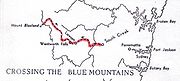
Official credit for crossing the Blue Mountains was eventually given to Gregory Blaxland
, William Lawson and William Charles Wentworth
. Following an exploratory trip in 1811, Blaxland, who wanted more grazing land, reasoned that the mountains could be crossed by following the ridges (thus creating the myth that the ridges were the easy way, when the easy way was in fact Coxs River). Accompanied by Lawson and Wentworth, he set out on 11 May 1813, and the party succeeded in crossing the mountains by 31 May. They ventured as far as to what is now Mount Blaxland, just west of Cox's River. On their return to Sydney, Governor Lachlan Macquarie
granted them 1000 acres (4 km²) of land each as a reward for their accomplishment.
In November 1813, Macquarie sent the surveyor George Evans
on an expedition to confirm the discoveries made by Blaxland and his party. He was also told to see if there existed enough arable land to justify settlement. The issue had become more urgent because the colony was in the grips of a drought.
Evans and his party reached the Fish
and Macquarie Rivers, and the site of Bathurst
. On 7 July 1814, construction of a road across the mountains was begun by William Cox
. The work was at the behest of Governor Macquarie. 30 convict labourers and 8 guards completed the road on 14 January 1815 after 27 weeks of hard work.
Since the Blue Mountains are rich in coal and shale, mining for these resources began in Hartley Vale in 1865. J.B. North ran a shale mine in the Jamison Valley in the 19th century, and other operations were set up in several places. Locations for mining activities included the Jamison Valley
, the upper Grose Valley, Newnes, Glen Davis
and the Asgard Swamp area near Mount Victoria
. Shale mining failed in the long run because it was not financially viable.
in 1788. The Carmarthen Hills were in the north of the region and the Lansdowne Hills were in the south. The name Blue Mountains, however, was preferred and is derived from the blue tinge the range takes on when viewed from a distance. The tinge is believed to be caused by mie scattering
which occurs when incoming ultraviolet radiation
is scattered by particles within the atmosphere creating a blue-greyish colour to any distant objects, including mountains and clouds. Volatile terpenoids emitted in large quantities by the abundant eucalyptus trees in the Blue Mountains may cause mie scattering and thus the blue haze for which the mountains were named.
Annual rainfall is about 1,050 mm in the Upper Blue Mountains with many misty days.
s. There are also many hanging swamps with button grass reeds and thick, deep black soil. Wollemia nobilis, the "Wollemi pine", a relict
of earlier vegetation of Gondwana
, is found in remote and isolated valleys of the Wollemi National Park
.
The main natural disasters to afflict the area are bushfires and severe storms. In recent years the lower mountains has been subjected to a series of bushfires which have caused great loss of property but relatively little loss of life. The upper mountains had not had a major fire for some decades until December 2002 (the Blackheath Glen Fire) and November 2006 when an extensive blaze in the Grose Valley threatened several communities including Bell
and Blackheath
(the Lawson Long Alley Fire). This latest fire burned for almost a month but was extinguished without loss of human life
or property. A program of winter burning seems to have been quite successful in reducing fires in the upper mountains.
The reason why this site was chosen to be included on the World Heritage list is quoted below:
, the yellow-bellied glider
and long-nosed potoroo
. There are also some rare reptiles, like the Blue Mountains water skink. There are also some dingo
s in the area, which form the top predators and hunt for grey kangaroos
.
New South Wales
New South Wales is a state of :Australia, located in the east of the country. It is bordered by Queensland, Victoria and South Australia to the north, south and west respectively. To the east, the state is bordered by the Tasman Sea, which forms part of the Pacific Ocean. New South Wales...
, Australia
Australia
Australia , officially the Commonwealth of Australia, is a country in the Southern Hemisphere comprising the mainland of the Australian continent, the island of Tasmania, and numerous smaller islands in the Indian and Pacific Oceans. It is the world's sixth-largest country by total area...
. It borders on Sydney
Sydney
Sydney is the most populous city in Australia and the state capital of New South Wales. Sydney is located on Australia's south-east coast of the Tasman Sea. As of June 2010, the greater metropolitan area had an approximate population of 4.6 million people...
's metropolitan area, its foothills starting approximately 50 kilometres west of the state capital
City of Sydney
The City of Sydney is the Local Government Area covering the Sydney central business district and surrounding inner city suburbs of the greater metropolitan area of Sydney, Australia...
. The area begins on the west side of the Nepean River
Nepean River
The Nepean River is a river in the coastal region of New South Wales, Australia.The headwaters of the Nepean River rise near Robertson, about 100 kilometres south of Sydney and about 15 kilometres from the coast. The river flows north in an unpopulated water catchment area into Nepean Dam, which...
and extends westward as far as Coxs River. Geologically, it is situated in the central parts of the Sydney basin
Sydney Basin
The Sydney Basin is a sedimentary basin on the east coast of New South Wales, Australia consisting of Permian and Triassic sedimentary rocks...
.
Consisting mainly of a sandstone plateau
Plateau
In geology and earth science, a plateau , also called a high plain or tableland, is an area of highland, usually consisting of relatively flat terrain. A highly eroded plateau is called a dissected plateau...
, the area is dissected by gorges up to 760 metres deep. The highest point of the range is Mount Werong at 1,215 metres above sea level
Sea level
Mean sea level is a measure of the average height of the ocean's surface ; used as a standard in reckoning land elevation...
. A large part of the Blue Mountains is incorporated into the Greater Blue Mountains Area
Greater Blue Mountains Area
The Greater Blue Mountains Area is a World Heritage Site in the Blue Mountains of New South Wales, Australia. It was inscribed on the World Heritage List at the 24th Session of the World Heritage Committee, held in Cairns from 27 November to 2 December 2000...
World Heritage Site
World Heritage Site
A UNESCO World Heritage Site is a place that is listed by the UNESCO as of special cultural or physical significance...
, consisting of seven national park areas and a conservation reserve.
The Blue Mountains area includes the local government areas of the City of Blue Mountains
City of Blue Mountains
The City of Blue Mountains is a local government area of New South Wales, Australia, governed by the Blue Mountains City Council. The city is located in the Blue Mountains range west of Sydney.-Demographics:...
, the City of Hawkesbury
City of Hawkesbury
The City of Hawkesbury is a Local Government Area of New South Wales, Australia, part of which is at the fringe of the Sydney metropolitan area, about 50 kilometres north-west of the Sydney central business district...
, the City of Lithgow
City of Lithgow
Lithgow is a Local Government Area in New South Wales, Australia that includes Lithgow and its surrounding area. It is on the Great Western Highway and the Main Western railway line.- Demographics :According to the , there:...
and Oberon
Oberon, New South Wales
-See also:*Oberon Correctional Centre*Mount Trickett*Mount Bindo*Shooters Hill-External links:***...
.
Aboriginal inhabitants
When Europeans arrived in Australia, the Blue Mountains had already been inhabited for several millennia by the Gundungurra people, now represented by the Gundungurra Tribal Council Aboriginal Corporation based in Katoomba.The Gundungurra creation story of the Blue Mountains tells that Dreamtime creatures Mirigan and Garangatch, half fish and half reptile, fought an epic battle which scarred the landscape into the Jamison Valley.
The Gundungurra Tribal Council is a not for profit organisation representing the Gundungurra traditional owners, promoting heritage and culture and providing a support for Gundungurra people connecting back to Country. The Gundungurra web site in the links section below has a virtual video tour of the Upper Blue Mountains.
Gundungurra Tribal Council Aboriginal Corporation has a registered Native Title Claim since 1995 over their traditional lands, which include the Blue Mountains and surrounding areas.
Examples of Aboriginal habitation can be found in many places. In the Red Hands Cave, a rock shelter near Glenbrook
Glenbrook, New South Wales
Glenbrook is a suburb of the Lower Blue Mountains of New South Wales, Australia. It is located 70 kilometres west of Sydney in the local government area of the City of Blue Mountains. At the 2006 census, Glenbrook had a population of 5,138 people....
, the walls contain hand stencils from adults and children. On the southern side of Queen Elizabeth Drive, at Wentworth Falls
Wentworth Falls, New South Wales
Wentworth Falls is a town in the Blue Mountains, New South Wales located 100 kilometres west of Sydney, and about 8 kilometres east of Katoomba, Australia on the Great Western Highway, with a Wentworth Falls railway station on the Main Western line. The town is situated at an elevation of...
, a rocky knoll has a large number of grinding grooves created by rubbing stone implements on the rock to shape and sharpen them. There are also carved images of animal tracks and an occupation cave. The site is known as Kings Tableland Aboriginal Site and dates back 22,000 years.
European history
Arthur PhillipArthur Phillip
Admiral Arthur Phillip RN was a British admiral and colonial administrator. Phillip was appointed Governor of New South Wales, the first European colony on the Australian continent, and was the founder of the settlement which is now the city of Sydney.-Early life and naval career:Arthur Phillip...
, the first governor of New South Wales, first glimpsed the extent of the Blue Mountains from a ridge at the site of today's Oakhill College, Castle Hill. He named them the Carmarthen Hills, 'some forty to sixty miles distant..." and he reckoned that the ground was "most suitable for government stock". This is the location where Gidley King in 1799 established a prison town for political prisoners from Ireland
Ireland
Ireland is an island to the northwest of continental Europe. It is the third-largest island in Europe and the twentieth-largest island on Earth...
and Scotland
Scotland
Scotland is a country that is part of the United Kingdom. Occupying the northern third of the island of Great Britain, it shares a border with England to the south and is bounded by the North Sea to the east, the Atlantic Ocean to the north and west, and the North Channel and Irish Sea to the...
. The same view that Arthur Phillip enjoyed in his day can be enjoyed today.
The native Aborigines knew two routes across the mountains: Bilpin Ridge, which is now the location of Bells Line of Road between Richmond
Richmond, New South Wales
Richmond is a town in New South Wales, north-west of Sydney, in the Local Government Area of the City of Hawkesbury. It is located at a latitude of 33° 35' 54" South and a longitude of 150°45' 04" east, 19 metres above sea level on the alluvial Hawkesbury River flats, at the foot of the Blue...
and Bell
Bell, New South Wales
Bell is a small rural/residential village in the Blue Mountains with an elevation of approximately 1100 metres above sea level. Bell is approximately 125 km west of Sydney, Australia by road or 137 km by rail, some 20 km east of Lithgow and 10 km north of Mount Victoria. It is a...
, and the Coxs River, a tributary of the Nepean River. It could be followed upstream to the open plains of the Kanimbla Valley, the type of country that farmers prize.
European settlers initially considered that fertile lands lay beyond the mountains, as was China in the belief of many convicts, but that this didn't matter much, since the mountains were impassable. This idea was, to some extent, convenient for local authorities. An "insurmountable" barrier would deter convicts from trying to escape in that direction.
A former convict, John Wilson, may have been the first European to cross the Blue Mountains. It is also believed that Mathew Everingham, 1795, may have also been partly successful based on letters he wrote at the time which came to light in the late 1980s. Wilson arrived with the First Fleet in 1788 and was freed in 1792. He settled in the bush, living with the Aborigines and even functioning as an intermediary between them and the settlers. In 1797 he returned to Sydney, claiming to have explored up to a hundred miles in all directions around Sydney, including across the mountains. His descriptions and observations were generally accurate, and it is possible that he had crossed the mountains via the southern aspect at the Coxs River corridor, guided by the Aborigines.
Governor Hunter was impressed by Wilson's skills and sent him on an expedition with John Price and others in January 1798. The party crossed the Nepean River and moved southwest towards the present site of Mittagong. There they turned west and found a route along the ridge where today the Wombeyan Caves Road is located. In the process they found a way to go west of the mountains, by going around them instead of across them. In March of the same year, Wilson and Price ventured to the Camden area, and then continued further south until they discovered Thirlmere Lakes, finally almost reaching the present site of Goulburn.
It is possible that the accomplishments of this expedition were suppressed by Hunter, who may not have wanted convicts to know that there was a relatively easy way out of Sydney. Wilson was killed by Aborigines after abducting one of their women for his personal use, but he had accomplished much as an explorer. He was never recognised as the first person to cross the mountains, possibly because his Coxs River journey could not be verified, while his route west of Mittagong may have been the "long way around" for a colony that had its eyes fixed on the sandstone fortress west of the Nepean.
Kanangra-Boyd National Park
Kanangra-Boyd is a national park in New South Wales, Australia, 100 km west of Sydney. It lies to the southwest of and is contiguous with the Blue Mountains National Park, and is part of the Greater Blue Mountains Area World Heritage Site ....
. Still, they did not find a definite route across the mountains.
Official credit for crossing the Blue Mountains was eventually given to Gregory Blaxland
Gregory Blaxland
Gregory Blaxland was a pioneer farmer and explorer in Australia.- Early life :Gregory Blaxland was born 17 June 1778 at Fordwich, Kent, England, the fourth son of John Blaxland, mayor from 1767 to 1774, whose family had owned estates nearby for generations, and Mary, daughter of Captain Parker,...
, William Lawson and William Charles Wentworth
William Wentworth
William Charles Wentworth was an Australian poet, explorer, journalist and politician, and one of the leading figures of early colonial New South Wales...
. Following an exploratory trip in 1811, Blaxland, who wanted more grazing land, reasoned that the mountains could be crossed by following the ridges (thus creating the myth that the ridges were the easy way, when the easy way was in fact Coxs River). Accompanied by Lawson and Wentworth, he set out on 11 May 1813, and the party succeeded in crossing the mountains by 31 May. They ventured as far as to what is now Mount Blaxland, just west of Cox's River. On their return to Sydney, Governor Lachlan Macquarie
Lachlan Macquarie
Major-General Lachlan Macquarie CB , was a British military officer and colonial administrator. He served as the last autocratic Governor of New South Wales, Australia from 1810 to 1821 and had a leading role in the social, economic and architectural development of the colony...
granted them 1000 acres (4 km²) of land each as a reward for their accomplishment.
In November 1813, Macquarie sent the surveyor George Evans
George Evans (explorer)
George William Evans was a surveyor and early explorer in the colony of New South Wales. Evans was born in Warwick, England, migrating to Australia in October 1802.-Early Career:...
on an expedition to confirm the discoveries made by Blaxland and his party. He was also told to see if there existed enough arable land to justify settlement. The issue had become more urgent because the colony was in the grips of a drought.
Evans and his party reached the Fish
Fish River (New South Wales)
- Rivers :There are two rivers in New South Wales called the Fish River.The Fish River rises on the plateau south east of Oberon, New South Wales, and flows generally to the north-west, becoming the main headwater of the Macquarie River just east of Bathurst, New South Wales. There is a reservoir...
and Macquarie Rivers, and the site of Bathurst
Bathurst, New South Wales
-CBD and suburbs:Bathurst's CBD is located on William, George, Howick, Russell, and Durham Streets. The CBD is approximately 25 hectares and surrounds two city blocks. Within this block layout is banking, government services, shopping centres, retail shops, a park* and monuments...
. On 7 July 1814, construction of a road across the mountains was begun by William Cox
William Cox (pioneer)
William Cox was an English soldier, known as an explorer, road builder and pioneer in the early period of British settlement in Australia.-Early life:...
. The work was at the behest of Governor Macquarie. 30 convict labourers and 8 guards completed the road on 14 January 1815 after 27 weeks of hard work.
Since the Blue Mountains are rich in coal and shale, mining for these resources began in Hartley Vale in 1865. J.B. North ran a shale mine in the Jamison Valley in the 19th century, and other operations were set up in several places. Locations for mining activities included the Jamison Valley
Jamison Valley
The Jamison Valley forms part of the Coxs River canyon system in the Blue Mountains of New South Wales, Australia. It is situated approximately 100 kilometres west of Sydney, capital of New South Wales, and a few kilometres south of Katoomba, the main town in the Blue Mountains.-History:The...
, the upper Grose Valley, Newnes, Glen Davis
Glen Davis, New South Wales
Glen Davis is a village in the Central Tablelands of New South Wales, Australia. The village is located in the local government area of the City of Lithgow. It is located 250 km north-west of Sydney and approximately 80 kilometres north of Lithgow...
and the Asgard Swamp area near Mount Victoria
Mount Victoria, New South Wales
Mount Victoria is a small township in the Blue Mountains of New South Wales, Australia. It is the westernmost village in the City of Blue Mountains, located approximately 120 kilometres via road from Sydney and 1043 metres above sea-level...
. Shale mining failed in the long run because it was not financially viable.
Etymology
Following European settlement of the Sydney area, the area was named the Carmarthen and Lansdowne Hills by Arthur PhillipArthur Phillip
Admiral Arthur Phillip RN was a British admiral and colonial administrator. Phillip was appointed Governor of New South Wales, the first European colony on the Australian continent, and was the founder of the settlement which is now the city of Sydney.-Early life and naval career:Arthur Phillip...
in 1788. The Carmarthen Hills were in the north of the region and the Lansdowne Hills were in the south. The name Blue Mountains, however, was preferred and is derived from the blue tinge the range takes on when viewed from a distance. The tinge is believed to be caused by mie scattering
Mie theory
The Mie solution to Maxwell's equations describes the scattering of electromagnetic radiation by a sphere...
which occurs when incoming ultraviolet radiation
Ultraviolet
Ultraviolet light is electromagnetic radiation with a wavelength shorter than that of visible light, but longer than X-rays, in the range 10 nm to 400 nm, and energies from 3 eV to 124 eV...
is scattered by particles within the atmosphere creating a blue-greyish colour to any distant objects, including mountains and clouds. Volatile terpenoids emitted in large quantities by the abundant eucalyptus trees in the Blue Mountains may cause mie scattering and thus the blue haze for which the mountains were named.
Physiography
The Blue Mountains area is a distinct physiographic section of the larger Hunter-Hawkesbury Sunkland province. This is in turn a part of the larger East Australian Cordillera physiographic division.Climate
The climate varies with altitude. At Katoomba (1,010 m) summer daytime temperatures are usually in the 20s with a few days extending into the 30s (Celsius). Night-time temperatures are usually in the teens. During the winter the temperature is typically around 12 to 13°C in the daytime with −3°C or so on clear nights and 2 to 3°C on cloudy nights. There are two to three snowfalls per year. In the lower mountains, however, the climate is significantly warmer.Annual rainfall is about 1,050 mm in the Upper Blue Mountains with many misty days.
Geography
The predominant natural vegetation of the higher ridges is eucalyptus forest. Heath-like vegetation is present on plateau edges above cliffs. The sheltered gorges often contain temperate rainforestRainforest
Rainforests are forests characterized by high rainfall, with definitions based on a minimum normal annual rainfall of 1750-2000 mm...
s. There are also many hanging swamps with button grass reeds and thick, deep black soil. Wollemia nobilis, the "Wollemi pine", a relict
Relict
A relict is a surviving remnant of a natural phenomenon.* In biology a relict is an organism that at an earlier time was abundant in a large area but now occurs at only one or a few small areas....
of earlier vegetation of Gondwana
Gondwana
In paleogeography, Gondwana , originally Gondwanaland, was the southernmost of two supercontinents that later became parts of the Pangaea supercontinent. It existed from approximately 510 to 180 million years ago . Gondwana is believed to have sutured between ca. 570 and 510 Mya,...
, is found in remote and isolated valleys of the Wollemi National Park
Wollemi National Park
Wollemi National Park is the second largest national park in New South Wales, and contains most of the largest wilderness area, the Wollemi Wilderness...
.
The main natural disasters to afflict the area are bushfires and severe storms. In recent years the lower mountains has been subjected to a series of bushfires which have caused great loss of property but relatively little loss of life. The upper mountains had not had a major fire for some decades until December 2002 (the Blackheath Glen Fire) and November 2006 when an extensive blaze in the Grose Valley threatened several communities including Bell
Bell, New South Wales
Bell is a small rural/residential village in the Blue Mountains with an elevation of approximately 1100 metres above sea level. Bell is approximately 125 km west of Sydney, Australia by road or 137 km by rail, some 20 km east of Lithgow and 10 km north of Mount Victoria. It is a...
and Blackheath
Blackheath, New South Wales
Blackheath is a small town located near the top of the Blue Mountains in New South Wales, Australia, 120 kilometres west north west of Sydney and 11 kilometres northwest of Katoomba. In 2006, Blackheath had a population of 4,177 people...
(the Lawson Long Alley Fire). This latest fire burned for almost a month but was extinguished without loss of human life
Human
Humans are the only living species in the Homo genus...
or property. A program of winter burning seems to have been quite successful in reducing fires in the upper mountains.
World Heritage listing
The Greater Blue Mountains Area was unanimously listed as a World Heritage Area by UNESCO on 29 November 2000, becoming the fourth area in New South Wales to be listed. The area totals roughly 10,000 square kilometres, including the Blue Mountains, Kanangra-Boyd, Wollemi, Gardens of Stone, Yengo, Nattai and Thirlmere Lakes National Parks, plus the Jenolan Caves Karst Conservation Reserve.The reason why this site was chosen to be included on the World Heritage list is quoted below:
Fauna
The Greater Blue Mountains Area is inhabited by over 400 different forms of animals. Among them are rare mammal species like spotted-tailed quoll, the koalaKoala
The koala is an arboreal herbivorous marsupial native to Australia, and the only extant representative of the family Phascolarctidae....
, the yellow-bellied glider
Yellow-bellied Glider
The Yellow-bellied Glider is an arboreal and nocturnal gliding possum that lives in a narrow range of native eucalypt forests down eastern Australia, reaching from northern Queensland to Victoria.-Habitat:...
and long-nosed potoroo
Long-nosed Potoroo
The Long-nosed Potoroo is a species of Australian potoroo. It is listed as Endangered in Victoria , Vulnerable in Queensland and nationally , although the IUCN lists it as Lower Risk.At first glance the Long-nosed Potoroo with its...
. There are also some rare reptiles, like the Blue Mountains water skink. There are also some dingo
Dingo
The Australian Dingo or Warrigal is a free-roaming wild dog unique to the continent of Australia, mainly found in the outback. Its original ancestors are thought to have arrived with humans from southeast Asia thousands of years ago, when dogs were still relatively undomesticated and closer to...
s in the area, which form the top predators and hunt for grey kangaroos
Eastern Grey Kangaroo
The Eastern Grey Kangaroo is a marsupial found in southern and eastern Australia, with a population of several million. It is also known as the Great Grey Kangaroo and the Forester Kangaroo...
.
Tourist attractions
- The Edge Cinema offers visitors a panoramic view of the Blue Mountains.
- The Giant Staircase walking track runs down a cliff into the Jamison Valley, near the Three SistersThree Sisters (Australia)The Three Sisters is a rock formation in the Blue Mountains of New South Wales, Australia. They are close to the town of Katoomba and are one of the Blue Mountains' best known sites, towering above the Jamison Valley. Their names are Meehni , Wimlah , and Gunnedoo .-Geology:The Sisters were formed...
, providing access to nature walks through the valley. - Jenolan CavesJenolan CavesThe Jenolan Caves are caves in the Blue Mountains, New South Wales, Australia; 175 kilometres west of Sydney. They are the most celebrated of several similar groups in the limestone of the country being the oldest discovered open caves in the world...
, a series of limestone caves south west of Katoomba. - The Katoomba Scenic Railway, was said to be the steepest railway in the world according to the Guinness Book of Records, and originally part of the Katoomba mining tramways constructed between 1878 and 1900. The cable railway line descends 415 metres through sandstone cliffs, via a rock tunnel with a maximum gradient of 52 degrees. Also, at this location is the Scenic Skyway, a glass-bottom aerial cable car that traverses an arm of the Jamison Valley, and the Scenic Cableway, the steepest aerial cable car in Australia.
- The Norman Lindsay Gallery and MuseumNorman Lindsay Gallery and MuseumThe Norman Lindsay Gallery and Museum is based in Faulconbridge in the Blue Mountains, Australia. The property is a stone cottage on a 42 acre block of land which was originally owned by the Australian artist and writer Norman Lindsay...
at Faulconbridge, operated by The National Trust of AustraliaNational Trust of AustraliaThe Australian Council of National Trusts is the peak body for community-based, non-government organisations committed to promoting and conserving Australia's indigenous, natural and historic heritage....
and is located inside the former Norman LindsayNorman LindsayNorman Alfred William Lindsay was an Australian artist, sculptor, writer, editorial cartoonist, scale modeler, and boxer. He was born in Creswick, Victoria....
homestead, Springwood. - The Toy Museum at Leura.
- Valley Heights Locomotive Depot Heritage MuseumValley Heights Locomotive Depot Heritage MuseumThe Valley Heights Locomotive Depot Heritage Museum is a railway museum located in Valley Heights, New South Wales, Australia. It is operated by the Blue Mountains Division of the New South Wales Rail Transport Museum....
. - The Zig Zag RailwayZig Zag RailwayThe Zig Zag Railway is a heritage railway at Lithgow in New South Wales, Australia on the site of the famous Great or Lithgow Zig Zag which operated between 1869 and 1910. As built, the line formed part of the Main West line from Sydney across the Blue Mountains and served to lower the line from...
: A steam-powered railway near LithgowLithgow, New South WalesLithgow is a city in the Central Tablelands of New South Wales, Australia and is the centre of the local political division City of Lithgow. It is located in a mountain valley named Lithgow's Valley by John Oxley in honour of William Lithgow, the first Auditor-General of New South Wales.Lithgow is...
. - A popular way to visit the Blue Mountains is by coach.
- The last remaining apple orchard on the Shipley PlateauShipley PlateauShipley Plateau is located south of Blackheath, New South Wales in the Blue Mountains of New South Wales, Australia. Faced with sandstone escarpments, the plateau is accessible by road and some of the land area is planted with fruit orchards...
.
Panorama
See also
- Aboriginal sites of New South WalesAboriginal sites of New South WalesAboriginal sites of New South Wales consist of a large number of places in the Australian state of New South Wales where it is still possible to see visible signs of the activities and culture of the Australian Aborigines—or Indigenous Australians—who occupied these areas before the arrival of...
(includes Blue Mountains) - List of mountains of Australia
External links
- Blue Mountains virtual video tour
- Gundungurra Blue Mountains Aboriginal traditional owners
- Blue Mountains, NSW, Australia - Aerial video footage of Katoomba, Leura and Wentworth Falls
- Blue Mountains on WikiTravel
- Various Blue Mountains info, based in Katoomba
- Official Blue Mountains National Park Web site
- Blue Mountains Family History Society