
Sydney Basin
Encyclopedia

Sedimentary basin
The term sedimentary basin is used to refer to any geographical feature exhibiting subsidence and consequent infilling by sedimentation. As the sediments are buried, they are subjected to increasing pressure and begin the process of lithification...
on the east coast of New South Wales
New South Wales
New South Wales is a state of :Australia, located in the east of the country. It is bordered by Queensland, Victoria and South Australia to the north, south and west respectively. To the east, the state is bordered by the Tasman Sea, which forms part of the Pacific Ocean. New South Wales...
, Australia
Australia
Australia , officially the Commonwealth of Australia, is a country in the Southern Hemisphere comprising the mainland of the Australian continent, the island of Tasmania, and numerous smaller islands in the Indian and Pacific Oceans. It is the world's sixth-largest country by total area...
consisting of Permian
Permian
The PermianThe term "Permian" was introduced into geology in 1841 by Sir Sir R. I. Murchison, president of the Geological Society of London, who identified typical strata in extensive Russian explorations undertaken with Edouard de Verneuil; Murchison asserted in 1841 that he named his "Permian...
and Triassic
Triassic
The Triassic is a geologic period and system that extends from about 250 to 200 Mya . As the first period of the Mesozoic Era, the Triassic follows the Permian and is followed by the Jurassic. Both the start and end of the Triassic are marked by major extinction events...
sedimentary rocks. It is named for the city of Sydney
Sydney
Sydney is the most populous city in Australia and the state capital of New South Wales. Sydney is located on Australia's south-east coast of the Tasman Sea. As of June 2010, the greater metropolitan area had an approximate population of 4.6 million people...
which is centred within it and stretches from Newcastle
Newcastle, New South Wales
The Newcastle metropolitan area is the second most populated area in the Australian state of New South Wales and includes most of the Newcastle and Lake Macquarie Local Government Areas...
in the north to Batemans Bay
Batemans Bay, New South Wales
- Media :Radio Stations*East Coast Radio 2EC *Power FM NSW South Coast - POWER FM from Nowra can also be received in parts of Batemans Bay on FM 94.9....
in the south, and west to the Blue Mountains towards Lithgow, and up until the edges of Mudgee in midwestern New South Wales.
The basin is also home to the major centres of the Newcastle
Newcastle, New South Wales
The Newcastle metropolitan area is the second most populated area in the Australian state of New South Wales and includes most of the Newcastle and Lake Macquarie Local Government Areas...
and Wollongong
Wollongong, New South Wales
Wollongong is a seaside city located in the Illawarra region of New South Wales, Australia. It lies on the narrow coastal strip between the Illawarra Escarpment and the Pacific Ocean, 82 kilometres south of Sydney...
, and contains economically significant reserves of coal
Coal
Coal is a combustible black or brownish-black sedimentary rock usually occurring in rock strata in layers or veins called coal beds or coal seams. The harder forms, such as anthracite coal, can be regarded as metamorphic rock because of later exposure to elevated temperature and pressure...
. Sydney’s famous harbour
Port Jackson
Port Jackson, containing Sydney Harbour, is the natural harbour of Sydney, Australia. It is known for its beauty, and in particular, as the location of the Sydney Opera House and Sydney Harbour Bridge...
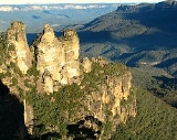
and the sculptured cliffs of the Blue Mountains are signature formations of relatively hard upper strata of sandstone
Sandstone
Sandstone is a sedimentary rock composed mainly of sand-sized minerals or rock grains.Most sandstone is composed of quartz and/or feldspar because these are the most common minerals in the Earth's crust. Like sand, sandstone may be any colour, but the most common colours are tan, brown, yellow,...
.
Topography
The Sydney Basin sits on the east coast of Australia. It's made up of a basinBasin
Basin may refer to:* Basin , a poem about Charlemagne's childhood* basin , the area of a drydock which can be flooded and drained* basin of attraction , an area of a nonlinear system with an attractor...
filled with near horizontal sandstones and shales of Permian to Triassic age that overlie older basement rocks of the Lachlan Fold Belt. The sedimentary rocks have been subject to uplift with gentle folding and minor faulting during the formation of the Great Dividing Range
Great Dividing Range
The Great Dividing Range, or the Eastern Highlands, is Australia's most substantial mountain range and the third longest in the world. The range stretches more than 3,500 km from Dauan Island off the northeastern tip of Queensland, running the entire length of the eastern coastline through...
.
Erosion by coastal streams have created a landscape of deep cliffed gorges and remains of plateaus across. The Sydney Basin Bioregion includes coastal landscapes of cliffs, beaches and estuaries.
Geology
Sydney is mostly Triassic rock, with a some recent igneous dykes and the volcanic neck. The Hawkesbury sandstoneSandstone
Sandstone is a sedimentary rock composed mainly of sand-sized minerals or rock grains.Most sandstone is composed of quartz and/or feldspar because these are the most common minerals in the Earth's crust. Like sand, sandstone may be any colour, but the most common colours are tan, brown, yellow,...
is some 200 metres (600 feet) thick, with shale lenses and fossil riverbeds dotted throughout it.
On separate ridges, a capping of Wianamatta shale
Shale
Shale is a fine-grained, clastic sedimentary rock composed of mud that is a mix of flakes of clay minerals and tiny fragments of other minerals, especially quartz and calcite. The ratio of clay to other minerals is variable. Shale is characterized by breaks along thin laminae or parallel layering...
makes richer soil, and below the sandstone, assorted shales, mudstones and other sedimentary layers go all the way down to the Permian
Permian
The PermianThe term "Permian" was introduced into geology in 1841 by Sir Sir R. I. Murchison, president of the Geological Society of London, who identified typical strata in extensive Russian explorations undertaken with Edouard de Verneuil; Murchison asserted in 1841 that he named his "Permian...
coal measures, deep below Sydney.
At some time in the past, the whole Sydney area was worn down to a flat plain
Plain
In geography, a plain is land with relatively low relief, that is flat or gently rolling. Prairies and steppes are types of plains, and the archetype for a plain is often thought of as a grassland, but plains in their natural state may also be covered in shrublands, woodland and forest, or...
, close to sea level. The land then rose up, the rivers and streams cut down into the rock. This flow produced a fern-leaf pattern of drainage that cut deeply between the tough sandstone which survived in ridges, high above the water, and in cliffs, where pieces of rock fell away, whenever a shale lens or a softer sandstone bed was eaten out, and a joint in the sandstone was eroded.
In recent times, the sea levels rose again, filling the river valleys. The Blue Mountains are the same sandstone, raised up in the past, except for a few ancient volcanic remnants like Mount Wilson
Mount Wilson
Mount Wilson can refer to several things:* Mount Wilson ** Mount Wilson Observatory* Mount Wilson, New South Wales, a mountain with a small hamlet in Australia* One of a list of peaks named Mount Wilson...
, and Mount Tomah, where the Mount Tomah Gardens are located.
The city has been shaped by its geology
Geology
Geology is the science comprising the study of solid Earth, the rocks of which it is composed, and the processes by which it evolves. Geology gives insight into the history of the Earth, as it provides the primary evidence for plate tectonics, the evolutionary history of life, and past climates...
. Almost all of the rocks exposed around Sydney will be sandstone. The sand
Sand
Sand is a naturally occurring granular material composed of finely divided rock and mineral particles.The composition of sand is highly variable, depending on the local rock sources and conditions, but the most common constituent of sand in inland continental settings and non-tropical coastal...
that was to become this sandstone was laid down in the Triassic period, about two hundred million years ago, a time when plants were ferns, reptiles were becoming dinosaurs, and mammals were only just being thought about.
There are some remnants of more recent volcanoes around, but almost everything seen in Sydney is a good old-fashioned sedimentary rock
Sedimentary rock
Sedimentary rock are types of rock that are formed by the deposition of material at the Earth's surface and within bodies of water. Sedimentation is the collective name for processes that cause mineral and/or organic particles to settle and accumulate or minerals to precipitate from a solution....
, lying in almost horizontal layers.
Shaping of Sydney
The sandstone that characterises Sydney was laid down almost 200 million years ago. The sand was washed from Broken Hill, and laid down in a bed that is about 200 metres thick. Currents washed through it, leaching out most of the minerals and leaving a very poor rock that made an insipid soil. They washed out channels in some places, while in others, the currents formed sand banks that show a characteristic current bedding or cross-bedding that can often be seen in cuttings.At a time in the past, monocline
Monocline
A monocline is a step-like fold in rock strata consisting of a zone of steeper dip within an otherwise horizontal or gently-dipping sequence.-Formation:Monoclines may be formed in several different ways...
formed to the west of Sydney. The monocline is a sloping bend that raises the sandstone well above where it is expected to be seen, and this is why the whole of the visible top of the Blue Mountains is made of sandstone.
The basin is bordered to the south and west by an older sequence of largely low-grade metamorphic and granitic rocks of the Lachlan Fold Belt
Lachlan Fold Belt
The Lachlan Fold Belt or Lachlan Orogen is a geological subdivision of the east part of Australia. It is a zone of folded and faulted rocks of similar age. It dominates New South Wales and Victoria, also extending into Tasmania, the Australian Capital Territory and Queensland. It was formed in...
. To the north, the rocks of the Sydney Basin pass into the Hunter Valley
Hunter Valley
The Hunter Region, more commonly known as the Hunter Valley, is a region of New South Wales, Australia, extending from approximately to north of Sydney with an approximate population of 645,395 people. Most of the population of the Hunter Region lives within of the coast, with 55% of the entire...
sequence that is transitional between the Sydney Basin and New England Fold Belt. To the north-west, the Sydney Basin sequence passes into the Gunnedah Basin. To the east, the Sydney Basin sequence continues offshore to the edge of the continental shelf
Continental shelf
The continental shelf is the extended perimeter of each continent and associated coastal plain. Much of the shelf was exposed during glacial periods, but is now submerged under relatively shallow seas and gulfs, and was similarly submerged during other interglacial periods. The continental margin,...
. The total maximum thickness
Thickness
Thickness may refer to:Thickness may refer to:* Thickness in graph theory* Thickness of layers in Geology* Thickness The difference in height between two atmospheric pressure levels* Thickness planer a woodworking machine...
of the Sydney Basin is in the range of some 5000 metres.
Post-Triassic sedimentation
Since rise of the basin in the Triassic period, up to around 600m of sediment has been put upon on parts of the continental shelf north of Sydney. Significant thicknesses of sediment (up to 80 m) have assembled in coastal depressions such as Botany BayBotany Bay
Botany Bay is a bay in Sydney, New South Wales, a few kilometres south of the Sydney central business district. The Cooks River and the Georges River are the two major tributaries that flow into the bay...
and Lake Macquarie
Lake Macquarie
The City of Lake Macquarie is a Local Government Area in New South Wales, Australia, approximately north of Sydney. It is immediately adjacent to the city of Newcastle and was proclaimed as a city from 7 September 1984.-The City of Lake Macquarie:...
. Most of this unconsolidated material is Cenozoic
Cenozoic
The Cenozoic era is the current and most recent of the three Phanerozoic geological eras and covers the period from 65.5 mya to the present. The era began in the wake of the Cretaceous–Tertiary extinction event at the end of the Cretaceous that saw the demise of the last non-avian dinosaurs and...
(i.e. less than 60 million years) or Quaternary
Quaternary
The Quaternary Period is the most recent of the three periods of the Cenozoic Era in the geologic time scale of the ICS. It follows the Neogene Period, spanning 2.588 ± 0.005 million years ago to the present...
(i.e. less than 2 million years) in age.
The Cumberland Plain
Cumberland Plain
The Cumberland Plain is a region in the Sydney Basin of New South Wales, Australia. The plain extends from 10 kilometres north of Windsor in the north, to Picton in the south; and...
was probably formed about 80 million years ago, associated with the opening of the Tasman Rift off eastern Australia, and this stopped the old stream patterns and largely resulted in the geography that we see today.
At times during the Cenozoic, more humid conditions existed than today, resulting in the formation of lateritic soils (i.e. iron
Iron
Iron is a chemical element with the symbol Fe and atomic number 26. It is a metal in the first transition series. It is the most common element forming the planet Earth as a whole, forming much of Earth's outer and inner core. It is the fourth most common element in the Earth's crust...
and aluminium
Aluminium
Aluminium or aluminum is a silvery white member of the boron group of chemical elements. It has the symbol Al, and its atomic number is 13. It is not soluble in water under normal circumstances....
rich soils). Present-day weathering
Weathering
Weathering is the breaking down of rocks, soils and minerals as well as artificial materials through contact with the Earth's atmosphere, biota and waters...
has resulted in new profiles being developed on these much older fossil soil profiles.
The rock sequences of the Sydney Basin have undergone only a little folding and faulting since they first formed. The only large-scale folds are those of the Lapstone Monocline (which extends in a north-south direction for over 150 km) at the eastern foothills of the Blue Mountains, and further west, the Tomah Monocline.
With more thorough and larger-scale excavations in the Sydney region in recent times, faults are becoming much more widely known, though nearly all appear to have been not active for at least the last 90 million years.
Igneous activity
Small amount of igneous activity has happened in the Early JurassicEarly Jurassic
The Early Jurassic epoch is the earliest of three epochs of the Jurassic period...
(i.e. 210 million years ago), Late Mesozoic
Mesozoic
The Mesozoic era is an interval of geological time from about 250 million years ago to about 65 million years ago. It is often referred to as the age of reptiles because reptiles, namely dinosaurs, were the dominant terrestrial and marine vertebrates of the time...
(i.e. 100-90 million years ago) and Cenozoic periods (i.e. 65 million years ago). The Early Jurassic activity resulted in the formation of the Prospect dolerite intrusion near Parramatta.
There are number of basaltic dykes of Jurassic age within the Sydney region. These are well exposed along the coastal cliffs and rock platforms, mostly trending in an east-south-east direction. A number of mainly Jurassic basaltic and doleritic dykes also occur at Long Reef, La Perouse
La Perouse
La Perouse may refer to* Jean-François de Galaup, comte de Lapérouse, a French naval officer and explorer,and the following places which were named after him:* La Perouse, New South Wales, a suburb of Sydney...
, Hunters Hill and Port Kembla.
Late Mesozoic activity resulted in the formation of many coastal basaltic dykes such as those along the New South Wales central coast, and Newcastle. Cenozoic activity was mainly in the form of isolated basalt flows that now form cappings to Mount Banks
Mount Banks
Mount Banks is a mountain in the Blue Mountains National Park, New South Wales, Australia. It is located approximately one hundred kilometres west of Sydney and eight kilometres from the nearest residential area, Mount Tomah.-Geography:...
and Mount Wilson in the Blue Mountains, and Peats Ridge on the central coast of New South Wales.
Geography
The Sydney basin extends through approximately 350 kilometres of coastline from Newcastle in the north to Durras Lake (near Batemans BayBatemans Bay, New South Wales
- Media :Radio Stations*East Coast Radio 2EC *Power FM NSW South Coast - POWER FM from Nowra can also be received in parts of Batemans Bay on FM 94.9....
) in the south. From Durras Lake the western boundary continues in a line through Lithgow
Lithgow, New South Wales
Lithgow is a city in the Central Tablelands of New South Wales, Australia and is the centre of the local political division City of Lithgow. It is located in a mountain valley named Lithgow's Valley by John Oxley in honour of William Lithgow, the first Auditor-General of New South Wales.Lithgow is...
to around Ulan (near Mudgee). To the north the boundary extends 120 kilometers along the Liverpool Range
Liverpool Range
The Liverpool Range is a mountain range and a lava-field province in New South Wales, Australia.The Liverpool Range starts from the volcanic plateau known as the Barrington Tops and runs for about 100 km westwards, forming the northern boundary of the Hunter Valley district...
to a point 80 kilometers north of Muswellbrook
Muswellbrook, New South Wales
Muswellbrook, a corruption of 'Muscle Brook', is a town and Local Government Area in New South Wales, Australia. The original spelling and etymology of the town's name is a matter of some debate...
, and then runs 200 kilometres back to the coast at Newcastle. To the east the basin continues to the edge of the continental shelf
Continental shelf
The continental shelf is the extended perimeter of each continent and associated coastal plain. Much of the shelf was exposed during glacial periods, but is now submerged under relatively shallow seas and gulfs, and was similarly submerged during other interglacial periods. The continental margin,...
.
The total area of the basin is approximately 44,000 square kilometres onshore plus 5,000 kilometres offshore.
The centre of the basin is located around 30 kilometres west of the Sydney CBD at Fairfield
Fairfield, New South Wales
Fairfield is a western suburb of Sydney, in the state of New South Wales, Australia. Fairfield is located 29 kilometres west of the Sydney central business district and is the administrative centre for the local government area of the City of Fairfield and is also partly in the local government...
.
See also
- Geology of AustraliaGeology of AustraliaAustralia is a continent situated on the Indo-Australian Plate.The geology of Australia includes virtually all known rock types and from all geological time periods spanning over 3.8 billion years of the Earth's history.-Components:...
- Narrabeen groupNarrabeen groupThe Narrabeen group of sedimentary rocks occurs in the Sydney Basin in eastern Australia. This series of rocks was formed in the triassic period....
- Cumberland PlainCumberland PlainThe Cumberland Plain is a region in the Sydney Basin of New South Wales, Australia. The plain extends from 10 kilometres north of Windsor in the north, to Picton in the south; and...
- Sydney sandstoneSydney sandstoneSydney sandstone is the common name for Sydney Basin Hawkesbury Sandstone, historically known as Yellowblock, is a sedimentary rock named after the Hawkesbury River north of Sydney, where this sandstone is particularly common....
- Wianamatta shaleWianamatta shaleWianamatta Shale is the uppermost outcropping unit in the Sydney Basin in New South Wales, Australia. It dates from the Triassic Period and generally comprises fine grained sedimentary rocks such as shales and laminites with less common sandstone units...
- Mittagong formationMittagong FormationThe Mittagong Formation is a type of sedimentary rock occurring in the Sydney Basin in eastern Australia. Formed in the triassic period. It may be seen as a narrow band of fine grained sandstone between the shale and the Hawkesbury sandstone . The maximum thickness is ten metres.In northern Sydney...