
Bitterroot Valley
Encyclopedia
Montana
Montana is a state in the Western United States. The western third of Montana contains numerous mountain ranges. Smaller, "island ranges" are found in the central third of the state, for a total of 77 named ranges of the Rocky Mountains. This geographical fact is reflected in the state's name,...
in the northwestern United States
United States
The United States of America is a federal constitutional republic comprising fifty states and a federal district...
. It extends over 100 miles (160 km) from remote Horse Creek Pass north to a point near the city of Missoula. To the west is the Bitterroot Range
Bitterroot Range
The Bitterroot Range runs along the border of Montana and Idaho in the northwestern United States. The range spans an area of 62,736 square kilometers and is named after the bitterroot , a small pink flower that is the state flower of Montana.- History :In 1805, the Corps of Discovery,...
and the large Selway-Bitterroot Wilderness Area
Selway-Bitterroot Wilderness
The Selway-Bitterroot Wilderness is a protected wilderness area in the states of Idaho and Montana, in the northwestern United States.At 1.3 million acres , it is one of the largest designated wilderness areas in the United States . It spans the Bitterroot Mountain Range, on the border between...
, and to the east is the smaller Sapphire Mountains
Sapphire Mountains
The Sapphire Mountains are a range of mountains located in southwestern Montana in the northwestern United States. From a point near the Clark Fork River and the city of Missoula, they run in a southerly direction for a distance of approximately 60 miles , making up much of the border between...
and the Anaconda-Pintler Wilderness Area
Anaconda-Pintler Wilderness
The Anaconda-Pintler Wilderness is located in southwestern Montana, in the northwestern United States. It runs for 40 miles along both sides of the crest of the Anaconda Range, covering almost 250 square miles . To the north are the Sapphire Mountains, and to the south is the Big Hole Valley...
.
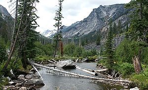
The southern end of the valley is split into the East and West Forks, and the northern end drains into the Clark Fork River. Connecting with the west side of the valley are numerous deeply-carved granite canyons, including scenic Blodgett Canyon
Blodgett Canyon
Blodgett Canyon is located in southwestern Montana in the northwestern United States. It is one of more than two dozen scenic canyons deeply carved into the eastern flanks of the Bitterroot Range in Bitterroot National Forest. Starting from a group of peaks at over 8500 feet along the...
and the valley formed by Lolo Creek. Highway 93
U.S. Route 93
U.S. Route 93 is a major north–south United States highway in the western United States. The southern terminus is at U.S. Route 60 in Wickenburg, Arizona. The northern terminus is at the Canadian border north of Eureka in Lincoln County, Montana, where the roadway continues into Roosville,...
runs through the center of the valley, exiting to the south over 7014 foot (2140 m) Lost Trail Pass.

Lolo, Montana
Lolo is a census-designated place in Missoula County, Montana, United States. It is part of the 'Missoula, Montana Metropolitan Statistical Area'. The population was 3,388 at the 2000 census. It is home to Travelers' Rest State Park, a site where Lewis and Clark camped in 1805 and again in 1806...
(in Missoula County
Missoula County, Montana
-National protected areas:*Bitterroot National Forest *Flathead National Forest *Lolo National Forest *Rattlesnake National Recreation Area-Demographics:...
), Florence
Florence, Montana
Florence is a census-designated place in Ravalli County, Montana, United States. The population was 901 at the 2000 census.-Geography:Florence is located at ....
, Stevensville
Stevensville, Montana
Stevensville is a town in Ravalli County, Montana, United States. The population was 1,553 at the 2000 census.-History:Stevensville is officially recognized as the first permanent settlement in the state of Montana...
, Victor
Victor, Montana
Victor is a census-designated place in Ravalli County, Montana, United States. The population was 859 at the 2000 census.-Geography:Victor is located at ....
, Corvallis
Corvallis, Montana
Corvallis is a census-designated place in Ravalli County, Montana, United States. The population was 443 at the 2000 census.-Geography:Corvallis is located at ....
, Hamilton
Hamilton, Montana
Hamilton is a city in and the county seat of Ravalli County, Montana, United States. The population was 3,705 at the 2000 census. Significant outlying population growth is shown in the area; the ZIP Code Tabulation Area for Hamilton's ZIP Code, 59840, had a population of 12,327at the 2000 census.-...
, Darby
Darby, Montana
Darby is a town in Ravalli County, Montana, United States. The population was 710 at the 2000 census. Darby is located near the southwestern border of Montana and Idaho, along the Continental Divide...
, Conner, and Sula, the latter being within present-day Ravalli County
Ravalli County, Montana
-National protected areas:*Bitterroot National Forest *Lee Metcalf National Wildlife Refuge*Lolo National Forest -Demographics:As of the census of 2000 , there were 36,070 people, 14,289 households, and 10,188 families residing in the county. The population density was 15 people per square mile...
. Hamilton, the largest town and the county seat of Ravalli County, is located at 46°14.8'N and 114°09.6'W at an elevation of 3570 ft (1090 m).
Historically, the valley was the long-term home of the Salish
Bitterroot Salish (tribe)
The Bitterroot Salish are one of three tribes of the Confederated Salish and Kootenai Tribes of the Flathead Nation in Montana. The Flathead Reservation is home to the Kootenai and Pend d'Oreilles tribes also.-Language:...
tribe of the Flathead
Confederated Salish and Kootenai Tribes of the Flathead Nation
The Confederated Salish and Kootenai Tribes of the Flathead Reservation are the Bitterroot Salish, Kootenai and Pend d'Oreilles Tribes. The Flatheads lived between the Cascade Mountains and Rocky Mountains. The Salish initially lived entirely east of the Continental Divide but established their...
nation. In early September 1805, the Lewis and Clark Expedition
Lewis and Clark Expedition
The Lewis and Clark Expedition, or ″Corps of Discovery Expedition" was the first transcontinental expedition to the Pacific Coast by the United States. Commissioned by President Thomas Jefferson and led by two Virginia-born veterans of Indian wars in the Ohio Valley, Meriwether Lewis and William...
crossed Lost Trail Pass from present-day Idaho in order to connect with the overland route through the Rocky Mountains
Rocky Mountains
The Rocky Mountains are a major mountain range in western North America. The Rocky Mountains stretch more than from the northernmost part of British Columbia, in western Canada, to New Mexico, in the southwestern United States...
. Passing down Camp Creek and the East Fork, they followed the Bitterroot River
Bitterroot River
The Bitterroot River is a tributary of the Clark Fork River in southwestern Montana, USA. It runs for about 75 miles south-to-north through the Bitterroot Valley, from the confluence of its West and East forks near Conner to the Clark Fork near Missoula.Ravalli County and Missoula County...
northward to the point where it connects with the Nez Perce Trail and Lolo Creek. Before continuing their difficult journey to the west, they named their camp Traveler's Rest. Returning to this site in early July of the following year, they split their Corps of Discovery, furthering their explorations both to the northeast (Lewis) and to the south (Clark).
The first white settlement in the valley was the founding in 1841 of St. Mary's Mission, near present-day Stevensville, by Father DeSmet. Fort Owen was established nearby in 1850, and difficult relations occurred between the white settlers and the Salish until 1891, when the native tribes were relocated to the north. In 1877 Chief Joseph
Chief Joseph
Hin-mah-too-yah-lat-kekt, popularly known as Chief Joseph, or Young Joseph was the leader of the Wal-lam-wat-kain band of Nez Perce during General Oliver O. Howard's attempt to forcibly remove his band and the other "non-treaty" Nez Perce to a reservation in Idaho...
and the Nez Perce tribe passed south through the Bitterroot Valley, fleeing the U.S. Army. They exited the East Fork via Gibbons Pass, near where they fought at the Battle of the Big Hole
Battle of the Big Hole
The Battle of the Big Hole was a costly battle in the Montana Territory between the Nez Percé and United States army during the Nez Perce War of 1877.-Background:...
.
Settlement has continued since that time. The population of Ravalli County in the 2000 census was 36,070. The major industries are ranching, agriculture, forestry, and tourism.
External links
- A virtual aerial image, looking northwest across all of the Bitterroot Range and the Bitterroot Valley, can be viewed at this external link.
- Bitterroot Valley Chamber of Commerce