
Binubulauan
Encyclopedia
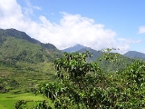
Binubulauan is a remote stratovolcano
, part of the volcanic Cordillera Central
mountain range.
Binubulauan is in the province
of Kalinga
, in the Cordillera Administrative Region
, one of the regions of the Philippines
, in the central north of the island of Luzon
, in the Philippines
.
PHIVOLCS also lists Ambalatungan at almost the same location.
The Smithsonian Institution's Global Volcanism Program
does not list Binubulauan separately but includes Binuluan as a cone subfeature in the listing for Ambalatungan:
Locals regard Binubulauan as THE volcano.
There has been some geological surveying related to the Batong Buhay gold mining activities, but the locals say no-one has ever climbed or surveyed Binubulauan because it is "too far away", "there's no reason to go there", "it is too difficult climbing that", and "even the geologists didn't bother".
Groundwork in 2007 and 2008 as part of a comprehensive systematic survey, shows volcanic related activity to the NW, W, SW, S, SE, E, around Binubulauan, with the peak of Binubulauan in the centre of the half-ring of activity.
Groundwork in the drier season in 2009 had to be abandoned due to tribal conflcits on the SW flank (Tinglayan-Tulgao tribal conflict), and unrelated inter-tribal conflicts on the NW and NE flanks (Upper Uma-Lubuagan conflict).
with volcanic activity.
Ground expeditions with GPS geomapping and photography show that the areas described as craters in the Smithsonian listing are not craters in the usual or volcanological sense of the word.
It seems the description 'a cluster of volcanoes' in the Smithsonian's listing is based on the use of the word 'crater', which is inappropriate. It therefore appears that the description 'cluster of volcanoes' is similarly inappropriate here.
Because there does not appear to be a cluster of volcanoes, the use of the word group
to describe the volcanic forms here also appears inaccurate.
Satellite terrain maps indicate Binubulauan could be the prehistorical primary with perhaps some daughter vents associated.
Binubulauan is usually covered in cloud or mist and so photographs from the few vantage points are difficult to obtain. But when Binubulauan does appear, an argument for daughter cones on the northwestern flank seems tenable. The village of Bangtitan in Upper Uma is a good vantage point for views and photography of Binubulauan on the rare occasions when the primary peak is not mist-enshrouded.
Sugo-oc is on the southern flank and is largely inaccessible from the northern and western flanks of Binubulauan. Also Sugo-oc is not mentioned by name or description in the Smithsonian's listing. If information about the 'eruption' had been originally obtained from the Pasil River valley people, there could have been some difficulty in explaining to non-Kalingan people the precise location of the fatalities and their cause in a different, unconnected, valley.
In 2007 and 2008, people in southern Kalinga around Binubulauan spoke of an 'eruption' at Sugo-oc in 1986 or 1987. During the Abra earthquake at 20:16 hours on Sunday 13 January 2008, buildings in Tinglayan shook and windows rattled for about 10 seconds. When speaking in English, the locals there at the time called this an 'eruption'. Gentle questioning of locals over months led to the conclusion that there are difficulties in communicating the difference between an eruption and an earthquake.
Further inquiries in southern Kalinga in December 2008 - January 2009 resulted in reports that there was an earthquake in 1986 which was felt throughout Labuagan Municipality and Tinglayan Municipality, and at the same time there was an eruption at Sugo-oc resulting in the ejection of ash and rock from Sugo-oc. Three people in Dananao village were killed by ejected rock during this eruption. Because of the eruption and deaths, there was a large migration out of Dananao village with the Dananao people taking possession of land on the Tubuk to Aurora road in eastern Kalinga and resettling there. Further details will be sought during a field expedition to Dananao and Sugo-oc when current intertribal unrest decreases.
Details about the eruption in 1952 are still scant. There may have been an eruption or there may have been a lahar at the Sugo-oc sulfur fumarole field located near the villages of Dananao and Sumadel, with loss of some dwellings and about 12 lives. There was a projectile eruption at the same location in 1986 killing three people.
In 2009, the Sugo-oc fumarole field is still active.
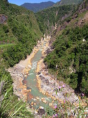
The linked photos http://commons.wikimedia.org/wiki/Image:Bu-ot80420cgb.jpg show this is a steep area. It is located at approximately 17 degrees 21.078 minutes N, 121 degrees, 05.676 minutes E, at an elevation of about 754 meters above sea level. It is beside the Pasil River on the steep western valley wall, with the path to Balatoc village immediately to the right of the fume hole field. When the photos were taken on 20 April 2008, there were two active steam vents with yellow water flowing from the vents, as well as from some other locations in the field, down to the Pasil River. The rocks of the Pasil River are heavily stained orange-yellow both upstream http://commons.wikimedia.org/wiki/Image:PasilRiver80420acg.jpg and downstream from the Bu-ot fume hole field.
Bu-ot is steep-sided but is not a crater.
In 2008, residents of Balatoc did not know of any place called Ambalatungan. However, it is suggested Bu-ot is the area the Smithsonian description calls Ambalatungan. Primary reason for suggesting this is because of the location of the other two fumarole fields in the valley in relation to this field, and the absence of any other fume hole field in the relevant area.
Bum-bag is on the eastern side of the Pasil river valley at an elevation of about 1437 metres above sea level.
It takes its name from the Bum-bag rice terraces (see pic) which one walks through at an elevation of about 1182 metres, on the way to the fume hole fields.
Field 1 http://commons.wikimedia.org/wiki/Image:Bum-bag1stFumaroleFieldacg80420.jpg is located about 100 metres north of field 2, had 11 separate fumarole vents, covered about 2 Ha, and was the most active of Fields 1, 2 and 3, as at April 2008.
Field 2 http://commons.wikimedia.org/wiki/Image:Bum-bag2ndFumaroleFieldbcg80420.jpg is located at N 17 degrees 19.590 minutes, E 121 degrees 05.016 minutes, had 16 separate
fumarole vents, and covered about 2 Ha, in April 2008
Field 3 http://commons.wikimedia.org/wiki/Image:Bum-bag3rdFumaroleField80420acg.jpg is located about 250 metres south of field 2. It was not examined closely in April 2008 because of some disagreement between the 5 guides and the landowner who belongs to a different tribe.
Field 4 is said to be located about 1 kilometre SE of field 2. On 20 April 2008, on site, Mr Carlon Baling-gao, co-owner of the fields (with his brother Alfred), said field 4 has the largest surface deposit of sulfur of all the fields and is the most active. He said the rattling, banging, and explosions, which used to go on underground stopped 'years ago', but he could not be any more specific as to time, and was not specific about which particular field.
There were broad swathes of bare ground between the numbered fields where all vegetation was absent except broken scorched trunks of mature pine tree. Whether these areas were former fields which blocked up, or areas which had recently been heated to a degree where all vegetation was crisped, or some other factor(s), was not clear in 2008.
There could be a further field over the ridge to the north of field 1. The owner and the guides compellingly warned against investigation there, but would not give any scientifically credible reason.
Bum-bag Fumarole Fields 1, 2 and 3, are steep-sided, but none is a crater.
Fields 1, 2 and 3 would appear to be consistent with the Smithsonian's 'Bumabag Volcano'.
Field 4 may be consistent with the Smithsonian's 'Podakan Volcano', though this needs further field investigation.
An on-site investigation was planned for the dryer season in April-May 2009, with access through Sumadel rather than Tulgao or Dananao, but had to be abandoned due to an escalation in the border dispute between the Tinglayan tribe and the Tulgao tribe.
Bu-ot fume hole field, Bum-bag fume hole fields, and Sugu-oc fume hole field, all have hot sulfurous water springs.
Along the Pasil River upstream from Bu-ot, 6 hot sulfurous water springs are said to be located. One of these is said to be a fume hole.
Downstream from Bu-ot on the Sun-ut River below the village of Ag-agama, is the Sun-ut hot sulfur water spring. The local priest in Ag-agama says there used to be a natural bowl on the banks of the Sun-ut River into which the spring flowed and in which the people of Ag-agama bathed daily. But a typhoon induced flooding of the Sun-ut river washed away the bowl and now the spring flows directly into the river. The spring is located on private property, the owner living in Ag-agama.
Along the Bunog River, downstream from Bunog Falls below Tulgao West, are 'numerous' hot sulfurous springs. The first is in sight of Bunog Falls 100 metres downstream from the Bunog Falls hot fresh water springs. Tulgao and Tinglayan locals say there is a hot salt water spring on the Bunog River which used to be harvested and the water 'cooked' to produce salt, before the Cordillera Highway was first blazed. They also say one of the springs has 'poison water' which kills animals and birds which drink from it. There is no path along the Bunog River, so systematic investigation will be difficult.
Further information from locals may disclose other hot water springs in tributaries off the Pasil River upstream from Bu-ot.
Unfortunately detailed satellite telemetry is not available. Available satellite mapping is too low in resolution to show likely fumarole fields in the remote jungles and higher elevation pine forests around Binubulauan.
Locals in Tinglayan and Lubuagan do not know of any hot sulfur water springs in the Chico River or its tributaries other than the Bunog River.
Active
Potentially Active
Inactive
It could appear that Binubulauan has been mislisted by Phivolcs.
It exhibits a number of the features of an active volcano. There are a number of sites with strong steam emission, fumarolic activity, surface sulfur deposits, hot fresh water springs, hot sulfurous water springs, sulfur staining of riverine systems, poisonous gas emissions, recent volcanic gas related deaths (>100 in last 20 years at Batong Buhay mines alone), heat destruction of vegetation, poisonous water, fumarole fields with new and shifting activity. Plus there was the explosive eruption at Sugu-oc fumarole field in 1986.
province, on northern Luzon
, in the Philippines
.
From Manila one can travel to Tabuk by car or coach - a journey of about 10 hours at night or longer by day, or one can travel from Manila to Bontoc by bus or 4 wheel drive, about 10 hours at night.
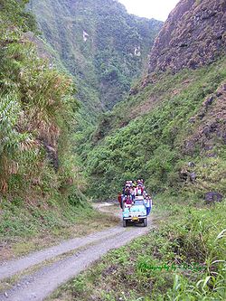
From Tabuk, capital of Kalinga province, one jeepney (see pic) leaves about 7am for Batong Buhay, in the Pasil River Valley (see pic). If there is sufficient demand a second jeepney may leave about 8am. Travelling this way from the north is about 5 hours. 4 wheel drive and high clearance is required for any private vehicle. There are no signposts and local knowledge is needed. There is no western style accommodation anywhere in the Pasil River Valley. Alight at Ag-agama drop-off to see the Sun-ut hot sulfur water spring http://commons.wikimedia.org/wiki/Image:Sun-utSulfurSpring81017acg.jpg. Alight at Balatoc drop-off to walk to Balatoc seeing the Bu-ot fume hole field on the way, and the orange-yellow stained rocks of the Pasil River. At Balatoc you might be able to arrange a local guide to take you to Bum-bag fume holes. Most of the walk is on tribal lands or private property. Walk from Balatoc to Bum-bag is only for the fit and takes about 5 hours one way. There is no accommodation at Bum-bag fume holes although there are some very basic huts at the Bum-bag rice terraces. Bum-bag fume holes are located on private property and permission is required from the owner. This might take up to a week to obtain because of the complete absence of modern communication in the area.
From Bontoc, capital of Mountain Province
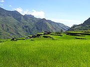
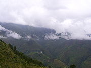
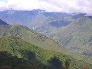
, a bus leaves for Tabuk at about 9am, and jeepneys also leave in the morning. Travelling this way from the south, after about 4 hours exit the bus at Tinglayan, in the Chico River Valley (see pic). A reliable local guide from Tinglayan (where reasonable accommodation is available) can take you to either Tulgao or Sumadel by foot - about 3 hours hike. Most of the year there is rain or mist along these paths and appropriate warm waterproof clothing is necessary. Along the Bunog River from Tulgao to Tinglayan are a number of hot clean water springs http://commons.wikimedia.org/wiki/Image:BunogFallsHotSpring71020acg.jpg, hot sulfurous water springs, and some poison water springs. In Tulgao or Sumadel you need to negotiate to find a local guide willing to take you to the Sugo-oc fumarole field. The trek from the village to the fumarole field is steep, difficult, at higher elevation, along carabao (buffalo) tracks. Tourists do not visit Sugo-oc and special arrangements need to be made. There is no western style accommodation in the villages of Tulgao or Sumadel, and no accommodation at all at Sugo-oc. There is a little used foot track from Sumadel to the plateau on the southern flank of Binubulauan but requires some months of planning and negotiation and a high level of fitness.
It is not known if Binubulauan itself has ever been climbed.
The terrain is rugged and undeveloped. Most usual transport is by foot, with jeepneys along the few roads.
Kalinga is a tribal area and is often subjected to inter-tribal conflict which can quickly escalate to armed warfare with many deaths. Most tribes have peace pacts with other tribes, but some tribes refuse to enter into the peace pact system. Tribal law (customary law) is recognised by the Republic Government and takes precedence over republic law. A person who trespasses, damages property, hurts another person, or kills another person, is likely to be dealt with under tribal law, which can allow revenge killings under some circumstances.
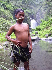
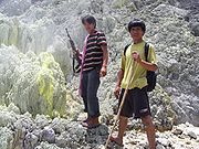
Foreigners and lowlanders are not covered by the peace pact process and need to be extremely careful if entering any of the lands around Binubulauan. Local guides/guards are needed at all times (see pic).
The Armed Forces of the Philippines (AFP) are not covered by the peace pact process, and if any soldier kills a Kalinga person, whether deliberately or accidentally, the family of the killed is obliged to make a revenge killing of the soldiers involved. When this happens, the army then usually escalates the problem, by itself undertaking reprisal killings - 'anti-subversive operations', against the citizens of the area in which the soldiers were executed. Foreigners need to keep away from these activities as the soldiers often shoot and kill first and ask questions later.
In second half 2008 elements from the AFP told the locals that all of Binubulauan, plus many other areas, are prohibited areas, which civilians may not enter and where the army will shoot anyone on sight.
Stratovolcano
A stratovolcano, also known as a composite volcano, is a tall, conical volcano built up by many layers of hardened lava, tephra, pumice, and volcanic ash. Unlike shield volcanoes, stratovolcanoes are characterized by a steep profile and periodic, explosive eruptions...
, part of the volcanic Cordillera Central
Cordillera Central, Luzon
The Cordillera Central is a massive mountain range situated in the northern central part of the island of Luzon, in the Philippines. Several provinces bound it, namely Benguet, Abra, Kalinga, Apayao, Mountain Province, Ifugao, and Baguio, a chartered city located entirely within Benguet...
mountain range.
Binubulauan is in the province
Provinces of the Philippines
The Provinces of the Philippines are the primary political and administrative divisions of the Philippines. There are 80 provinces at present, further subdivided into component cities and municipalities. The National Capital Region, as well as independent cities, are autonomous from any provincial...
of Kalinga
Kalinga
Kalinga is a landlocked province of the Philippines in the Cordillera Administrative Region in Luzon. Its capital is Tabuk and borders Mountain Province to the south, Abra to the west, Isabela to the east, Cagayan to the northeast, and Apayao to the north...
, in the Cordillera Administrative Region
Cordillera Administrative Region
The Cordillera Administrative Region is a region in the Philippines composed of the provinces of Abra, Apayao, Benguet, Ifugao, Kalinga and Mountain Province, as well as Baguio City, the regional center. The Cordillera Administrative Region encompasses most of the areas within the Cordillera...
, one of the regions of the Philippines
Regions of the Philippines
In the Philippines, regions are administrative divisions that serve primarily to organize the provinces of the country for administrative convenience. Currently, the archipelagic republic of the Philippines is divided into 17 regions...
, in the central north of the island of Luzon
Luzon
Luzon is the largest island in the Philippines. It is located in the northernmost region of the archipelago, and is also the name for one of the three primary island groups in the country centered on the Island of Luzon...
, in the Philippines
Philippines
The Philippines , officially known as the Republic of the Philippines , is a country in Southeast Asia in the western Pacific Ocean. To its north across the Luzon Strait lies Taiwan. West across the South China Sea sits Vietnam...
.
Current Listings
The Philippines Institute of Volcanology and Seismology (PHIVOLCS) lists Binubulauan (under a variant spelling) as one of the Philippines' inactive volcanoes. Details given on the PHIVOLCS website are:- Name Binuluan, Co-ordinates N 17°15' E 121°08', Province Kalinga-Apayo, Region Cordillera Administrative Region, Elevation 2329 meters ASL.
PHIVOLCS also lists Ambalatungan at almost the same location.
The Smithsonian Institution's Global Volcanism Program
Global Volcanism Program
The Smithsonian Institution's Global Volcanism Program documents Earth's volcanoes and their eruptive history over the past 10,000 years. The GVP reports on current eruptions from around the world as well as maintaining a database repository on active volcanoes and their eruptions. In this way, a...
does not list Binubulauan separately but includes Binuluan as a cone subfeature in the listing for Ambalatungan:
- A little-known cluster of volcanoes in the Cordillera Central of northern Luzon is known as Ambalatungan by Alvir (1956) and the Philippine Commission of Volcanology (1981) and as Mount Binuluan by Wolfe (1982, pers. comm.). The dacitic Ambalatungan Group was described as consisting of three volcanoes constructed along a roughly E-W line. Ambalatungan volcano proper contains a steep-walled crater with hot springs and vigorous sulfur-encrusted fumarolic vents that produce loud noises. Bumabag volcano, 3 km east of Ambalatungan, has two craters that also show strong fumarolic activity. Podakan volcano, 1 km SE of Bumabag, also has a large steam vent. A possible steam eruption was reported from 2329-m-high Mount Binuluan (whose relationship to the previously mentioned volcanoes is unclear) in 1952, during which a sulfur-rich debris flow killed a dozen people.
Ambalatungan
Locals living in the surrounding barangays in the Pasil River valley in 2007 and 2008 were unfamiliar with the name Ambalatungan. Reasons for the original appellation need further investigation.Binubulauan
The highest peak in the area is Binubulauan, pronounced Bin-oo-boo-LAH-wahn (Lubuaganyen dialect), with 'oo' as in look.Locals regard Binubulauan as THE volcano.
There has been some geological surveying related to the Batong Buhay gold mining activities, but the locals say no-one has ever climbed or surveyed Binubulauan because it is "too far away", "there's no reason to go there", "it is too difficult climbing that", and "even the geologists didn't bother".
Groundwork in 2007 and 2008 as part of a comprehensive systematic survey, shows volcanic related activity to the NW, W, SW, S, SE, E, around Binubulauan, with the peak of Binubulauan in the centre of the half-ring of activity.
Groundwork in the drier season in 2009 had to be abandoned due to tribal conflcits on the SW flank (Tinglayan-Tulgao tribal conflict), and unrelated inter-tribal conflicts on the NW and NE flanks (Upper Uma-Lubuagan conflict).
Craters and Cluster
2007 and 2008 groundwork indicated that the Smithsonian's description of 'craters' is unsatisfactory. Ground expeditions and discussions with local elders in a 10 kilometre radius around Binubulauan in 2007 and 2008, did not disclose any cratersVolcanic crater
A volcanic crater is a circular depression in the ground caused by volcanic activity. It is typically a basin, circular in form within which occurs a vent from which magma erupts as gases, lava, and ejecta. A crater can be of large dimensions, and sometimes of great depth...
with volcanic activity.
Ground expeditions with GPS geomapping and photography show that the areas described as craters in the Smithsonian listing are not craters in the usual or volcanological sense of the word.
It seems the description 'a cluster of volcanoes' in the Smithsonian's listing is based on the use of the word 'crater', which is inappropriate. It therefore appears that the description 'cluster of volcanoes' is similarly inappropriate here.
Because there does not appear to be a cluster of volcanoes, the use of the word group
Volcanic group
A volcanic group is a collection of related volcanoes or volcanic landforms. Note that the term is also used in a different sense when it denotes a suite of associated rock strata largely of volcanic origin; see group for details.-Notable volcanic groups:-See also:*Complex...
to describe the volcanic forms here also appears inaccurate.
Satellite terrain maps indicate Binubulauan could be the prehistorical primary with perhaps some daughter vents associated.
Binubulauan is usually covered in cloud or mist and so photographs from the few vantage points are difficult to obtain. But when Binubulauan does appear, an argument for daughter cones on the northwestern flank seems tenable. The village of Bangtitan in Upper Uma is a good vantage point for views and photography of Binubulauan on the rare occasions when the primary peak is not mist-enshrouded.
Eruption
In 2007 and 2008, ninety and one hundred year old elders in Tinglayan and Tulgao said the loss of life in 1952 was caused by an eruption during a typhoon with the collapse of a natural earth bank below Sugo-oc fumarole field, high on the northern side of the Bunog River valley, with the consequent mudslide burying a few houses below and killing maybe 12 people or thereabouts.Sugo-oc is on the southern flank and is largely inaccessible from the northern and western flanks of Binubulauan. Also Sugo-oc is not mentioned by name or description in the Smithsonian's listing. If information about the 'eruption' had been originally obtained from the Pasil River valley people, there could have been some difficulty in explaining to non-Kalingan people the precise location of the fatalities and their cause in a different, unconnected, valley.
In 2007 and 2008, people in southern Kalinga around Binubulauan spoke of an 'eruption' at Sugo-oc in 1986 or 1987. During the Abra earthquake at 20:16 hours on Sunday 13 January 2008, buildings in Tinglayan shook and windows rattled for about 10 seconds. When speaking in English, the locals there at the time called this an 'eruption'. Gentle questioning of locals over months led to the conclusion that there are difficulties in communicating the difference between an eruption and an earthquake.
Further inquiries in southern Kalinga in December 2008 - January 2009 resulted in reports that there was an earthquake in 1986 which was felt throughout Labuagan Municipality and Tinglayan Municipality, and at the same time there was an eruption at Sugo-oc resulting in the ejection of ash and rock from Sugo-oc. Three people in Dananao village were killed by ejected rock during this eruption. Because of the eruption and deaths, there was a large migration out of Dananao village with the Dananao people taking possession of land on the Tubuk to Aurora road in eastern Kalinga and resettling there. Further details will be sought during a field expedition to Dananao and Sugo-oc when current intertribal unrest decreases.
Details about the eruption in 1952 are still scant. There may have been an eruption or there may have been a lahar at the Sugo-oc sulfur fumarole field located near the villages of Dananao and Sumadel, with loss of some dwellings and about 12 lives. There was a projectile eruption at the same location in 1986 killing three people.
In 2009, the Sugo-oc fumarole field is still active.
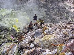
Bu-ot Fumarole Field
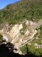
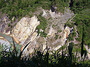
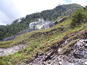
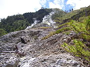
The Bu-ot Fumarole Field (Balatoc dialect) is located on the western valley side above the Pasil River, immediately below the village of Balatoc, on Balatoc tribal land.The linked photos http://commons.wikimedia.org/wiki/Image:Bu-ot80420cgb.jpg show this is a steep area. It is located at approximately 17 degrees 21.078 minutes N, 121 degrees, 05.676 minutes E, at an elevation of about 754 meters above sea level. It is beside the Pasil River on the steep western valley wall, with the path to Balatoc village immediately to the right of the fume hole field. When the photos were taken on 20 April 2008, there were two active steam vents with yellow water flowing from the vents, as well as from some other locations in the field, down to the Pasil River. The rocks of the Pasil River are heavily stained orange-yellow both upstream http://commons.wikimedia.org/wiki/Image:PasilRiver80420acg.jpg and downstream from the Bu-ot fume hole field.
Bu-ot is steep-sided but is not a crater.
In 2008, residents of Balatoc did not know of any place called Ambalatungan. However, it is suggested Bu-ot is the area the Smithsonian description calls Ambalatungan. Primary reason for suggesting this is because of the location of the other two fumarole fields in the valley in relation to this field, and the absence of any other fume hole field in the relevant area.
Bum-bag Fumarole Fields
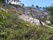
Bum-bag fumarole fields (Balatoc dialect), (or Djum-ag in Upper Uma dialect), are located approximately 3 kilometres east of Bu-ot, on Batong Buhay tribal land. Pronunciation is closest to boom-bug in English, with boom pronounced like look.Bum-bag is on the eastern side of the Pasil river valley at an elevation of about 1437 metres above sea level.
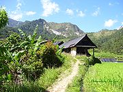
It takes its name from the Bum-bag rice terraces (see pic) which one walks through at an elevation of about 1182 metres, on the way to the fume hole fields.
Field 1 http://commons.wikimedia.org/wiki/Image:Bum-bag1stFumaroleFieldacg80420.jpg is located about 100 metres north of field 2, had 11 separate fumarole vents, covered about 2 Ha, and was the most active of Fields 1, 2 and 3, as at April 2008.
Field 2 http://commons.wikimedia.org/wiki/Image:Bum-bag2ndFumaroleFieldbcg80420.jpg is located at N 17 degrees 19.590 minutes, E 121 degrees 05.016 minutes, had 16 separate
fumarole vents, and covered about 2 Ha, in April 2008
Field 3 http://commons.wikimedia.org/wiki/Image:Bum-bag3rdFumaroleField80420acg.jpg is located about 250 metres south of field 2. It was not examined closely in April 2008 because of some disagreement between the 5 guides and the landowner who belongs to a different tribe.
Field 4 is said to be located about 1 kilometre SE of field 2. On 20 April 2008, on site, Mr Carlon Baling-gao, co-owner of the fields (with his brother Alfred), said field 4 has the largest surface deposit of sulfur of all the fields and is the most active. He said the rattling, banging, and explosions, which used to go on underground stopped 'years ago', but he could not be any more specific as to time, and was not specific about which particular field.
There were broad swathes of bare ground between the numbered fields where all vegetation was absent except broken scorched trunks of mature pine tree. Whether these areas were former fields which blocked up, or areas which had recently been heated to a degree where all vegetation was crisped, or some other factor(s), was not clear in 2008.
There could be a further field over the ridge to the north of field 1. The owner and the guides compellingly warned against investigation there, but would not give any scientifically credible reason.
Bum-bag Fumarole Fields 1, 2 and 3, are steep-sided, but none is a crater.
Fields 1, 2 and 3 would appear to be consistent with the Smithsonian's 'Bumabag Volcano'.
Field 4 may be consistent with the Smithsonian's 'Podakan Volcano', though this needs further field investigation.
Sugo-oc Fumarole Field
In October 2007 the Sugo-oc fumarole field was sighted and photographed from the opposite (southern) side of the Bunog River valley, on the Tinglayan Tulgao road. Unfortunately mist, cloud, and intermittent rain precluded any clear photo, and heavy rain on the return journey the next day prevented all photographing.An on-site investigation was planned for the dryer season in April-May 2009, with access through Sumadel rather than Tulgao or Dananao, but had to be abandoned due to an escalation in the border dispute between the Tinglayan tribe and the Tulgao tribe.
Hot Springs
Numerous hot springs, both fresh water, and sulfurous water, exist in a wide half ring around the south and western sides of Binubulauan.Bu-ot fume hole field, Bum-bag fume hole fields, and Sugu-oc fume hole field, all have hot sulfurous water springs.
Along the Pasil River upstream from Bu-ot, 6 hot sulfurous water springs are said to be located. One of these is said to be a fume hole.
Downstream from Bu-ot on the Sun-ut River below the village of Ag-agama, is the Sun-ut hot sulfur water spring. The local priest in Ag-agama says there used to be a natural bowl on the banks of the Sun-ut River into which the spring flowed and in which the people of Ag-agama bathed daily. But a typhoon induced flooding of the Sun-ut river washed away the bowl and now the spring flows directly into the river. The spring is located on private property, the owner living in Ag-agama.
Along the Bunog River, downstream from Bunog Falls below Tulgao West, are 'numerous' hot sulfurous springs. The first is in sight of Bunog Falls 100 metres downstream from the Bunog Falls hot fresh water springs. Tulgao and Tinglayan locals say there is a hot salt water spring on the Bunog River which used to be harvested and the water 'cooked' to produce salt, before the Cordillera Highway was first blazed. They also say one of the springs has 'poison water' which kills animals and birds which drink from it. There is no path along the Bunog River, so systematic investigation will be difficult.
Further information from locals may disclose other hot water springs in tributaries off the Pasil River upstream from Bu-ot.
Unfortunately detailed satellite telemetry is not available. Available satellite mapping is too low in resolution to show likely fumarole fields in the remote jungles and higher elevation pine forests around Binubulauan.
Locals in Tinglayan and Lubuagan do not know of any hot sulfur water springs in the Chico River or its tributaries other than the Bunog River.
Classification
Phivolcs classifies volcanoes http://www.phivolcs.dost.gov.ph/index.php?option=com_content&task=view&id=50&Itemid=86 as:Active
- Eruption in historic times
- Historical record - 500 years
- C14 dating - 10,000 years
- Local seismic activity
- Oral / folkloric history
Potentially Active
- Solfataras / Fumaroles
- Geologically young (possibly erupted < 10,000 years and for calderas and large systems - possibly < 25,000 years).
- Young-looking geomorphology (thin soil cover/sparse vegetation; low degree of erosion and dissection; young vent features; +/- vegetation cover).
- Suspected seismic activity.
- Documented local ground deformation
- Geochemical indicators of magmatic involvement.
- Geophysical proof of magma bodies.
- Strong connection with subduction zones and external tectonic settings.
Inactive
- No record of eruption and its form is beginning to change by the agents of weathering and erosion via formation of deep and long gullies.
Reclassification
Phivolcs has listed Ambalatungan (Binubulauan) as inactive http://www.phivolcs.dost.gov.ph/index.php?option=com_content&task=view&id=59&Itemid=116.It could appear that Binubulauan has been mislisted by Phivolcs.
It exhibits a number of the features of an active volcano. There are a number of sites with strong steam emission, fumarolic activity, surface sulfur deposits, hot fresh water springs, hot sulfurous water springs, sulfur staining of riverine systems, poisonous gas emissions, recent volcanic gas related deaths (>100 in last 20 years at Batong Buhay mines alone), heat destruction of vegetation, poisonous water, fumarole fields with new and shifting activity. Plus there was the explosive eruption at Sugu-oc fumarole field in 1986.
Site difficulties
Access to the site is very difficult. It is located in KalingaKalinga
Kalinga is a landlocked province of the Philippines in the Cordillera Administrative Region in Luzon. Its capital is Tabuk and borders Mountain Province to the south, Abra to the west, Isabela to the east, Cagayan to the northeast, and Apayao to the north...
province, on northern Luzon
Luzon
Luzon is the largest island in the Philippines. It is located in the northernmost region of the archipelago, and is also the name for one of the three primary island groups in the country centered on the Island of Luzon...
, in the Philippines
Philippines
The Philippines , officially known as the Republic of the Philippines , is a country in Southeast Asia in the western Pacific Ocean. To its north across the Luzon Strait lies Taiwan. West across the South China Sea sits Vietnam...
.
From Manila one can travel to Tabuk by car or coach - a journey of about 10 hours at night or longer by day, or one can travel from Manila to Bontoc by bus or 4 wheel drive, about 10 hours at night.
From Tabuk, capital of Kalinga province, one jeepney (see pic) leaves about 7am for Batong Buhay, in the Pasil River Valley (see pic). If there is sufficient demand a second jeepney may leave about 8am. Travelling this way from the north is about 5 hours. 4 wheel drive and high clearance is required for any private vehicle. There are no signposts and local knowledge is needed. There is no western style accommodation anywhere in the Pasil River Valley. Alight at Ag-agama drop-off to see the Sun-ut hot sulfur water spring http://commons.wikimedia.org/wiki/Image:Sun-utSulfurSpring81017acg.jpg. Alight at Balatoc drop-off to walk to Balatoc seeing the Bu-ot fume hole field on the way, and the orange-yellow stained rocks of the Pasil River. At Balatoc you might be able to arrange a local guide to take you to Bum-bag fume holes. Most of the walk is on tribal lands or private property. Walk from Balatoc to Bum-bag is only for the fit and takes about 5 hours one way. There is no accommodation at Bum-bag fume holes although there are some very basic huts at the Bum-bag rice terraces. Bum-bag fume holes are located on private property and permission is required from the owner. This might take up to a week to obtain because of the complete absence of modern communication in the area.
From Bontoc, capital of Mountain Province
Mountain Province
Mountain Province is a landlocked province of the Philippines in the Cordillera Administrative Region in Luzon. Its capital is Bontoc and borders, clockwise from the south, Ifugao, Benguet, Ilocos Sur, Abra, Kalinga, and Isabela.Mountain Province is sometimes incorrectly named Mountain in some...
, a bus leaves for Tabuk at about 9am, and jeepneys also leave in the morning. Travelling this way from the south, after about 4 hours exit the bus at Tinglayan, in the Chico River Valley (see pic). A reliable local guide from Tinglayan (where reasonable accommodation is available) can take you to either Tulgao or Sumadel by foot - about 3 hours hike. Most of the year there is rain or mist along these paths and appropriate warm waterproof clothing is necessary. Along the Bunog River from Tulgao to Tinglayan are a number of hot clean water springs http://commons.wikimedia.org/wiki/Image:BunogFallsHotSpring71020acg.jpg, hot sulfurous water springs, and some poison water springs. In Tulgao or Sumadel you need to negotiate to find a local guide willing to take you to the Sugo-oc fumarole field. The trek from the village to the fumarole field is steep, difficult, at higher elevation, along carabao (buffalo) tracks. Tourists do not visit Sugo-oc and special arrangements need to be made. There is no western style accommodation in the villages of Tulgao or Sumadel, and no accommodation at all at Sugo-oc. There is a little used foot track from Sumadel to the plateau on the southern flank of Binubulauan but requires some months of planning and negotiation and a high level of fitness.
It is not known if Binubulauan itself has ever been climbed.
The terrain is rugged and undeveloped. Most usual transport is by foot, with jeepneys along the few roads.
Kalinga is a tribal area and is often subjected to inter-tribal conflict which can quickly escalate to armed warfare with many deaths. Most tribes have peace pacts with other tribes, but some tribes refuse to enter into the peace pact system. Tribal law (customary law) is recognised by the Republic Government and takes precedence over republic law. A person who trespasses, damages property, hurts another person, or kills another person, is likely to be dealt with under tribal law, which can allow revenge killings under some circumstances.
Foreigners and lowlanders are not covered by the peace pact process and need to be extremely careful if entering any of the lands around Binubulauan. Local guides/guards are needed at all times (see pic).
The Armed Forces of the Philippines (AFP) are not covered by the peace pact process, and if any soldier kills a Kalinga person, whether deliberately or accidentally, the family of the killed is obliged to make a revenge killing of the soldiers involved. When this happens, the army then usually escalates the problem, by itself undertaking reprisal killings - 'anti-subversive operations', against the citizens of the area in which the soldiers were executed. Foreigners need to keep away from these activities as the soldiers often shoot and kill first and ask questions later.
In second half 2008 elements from the AFP told the locals that all of Binubulauan, plus many other areas, are prohibited areas, which civilians may not enter and where the army will shoot anyone on sight.
See also
- Erupting volcanos in the Philippines
- Active volcanos in the Philippines
- Potentially active volcanos in the Philippines
- Inactive volcanos in the Philippines
- VolcanoVolcano2. Bedrock3. Conduit 4. Base5. Sill6. Dike7. Layers of ash emitted by the volcano8. Flank| 9. Layers of lava emitted by the volcano10. Throat11. Parasitic cone12. Lava flow13. Vent14. Crater15...