
Point Lookout, New South Wales
Encyclopedia
Point Lookout is the name of a mountain in the New England National Park
, near Ebor
, Australia
.
It is the second highest peak in the Snowy Range, a spur of the Great Dividing Range
which forms the highest part, and eastern edge of the Northern Tablelands
. During cold spells the mountain may receive a light dusting of snow.
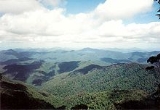
Point Lookout is also the name of the main visitor location in the New England National Park. The Point Lookout Road is accessed via Waterfall Way
and is 85 kilometres east of Armidale
and 75 km from Dorrigo. The lookouts have spectacular views east across the Bellinger River
valley, out to the more developed areas of the north coast of New South Wales and the Pacific Ocean
on a clear day.
On the escarpment only 10 minutes walk south is Banksia Point
. There are a number of cabins and a hut here. These are available from the National Parks and Wildlife Service
for short term stays in the park.
New England National Park
New England National Park is situated on the Northern Tablelands in the New England region of New South Wales, Australia, 560 km north of Sydney. It is about 10 km south of Waterfall Way, just 85 km east of Armidale and 65 km west of Coffs Harbour...
, near Ebor
Ebor, New South Wales
Ebor is a village on Waterfall Way on the Northern Tablelands, New South Wales, Australia. It is situated about east of Armidale and about a third of the way between Armidale and the coast. At the 2006 census, Ebor and the surrounding area had a population of 160...
, Australia
Australia
Australia , officially the Commonwealth of Australia, is a country in the Southern Hemisphere comprising the mainland of the Australian continent, the island of Tasmania, and numerous smaller islands in the Indian and Pacific Oceans. It is the world's sixth-largest country by total area...
.
It is the second highest peak in the Snowy Range, a spur of the Great Dividing Range
Great Dividing Range
The Great Dividing Range, or the Eastern Highlands, is Australia's most substantial mountain range and the third longest in the world. The range stretches more than 3,500 km from Dauan Island off the northeastern tip of Queensland, running the entire length of the eastern coastline through...
which forms the highest part, and eastern edge of the Northern Tablelands
Northern Tablelands, New South Wales
The Northern Tablelands, also known as the New England Tableland, is a plateau and a region of the Great Dividing Range in northern New South Wales, Australia. It includes the New England Range, the narrow highlands area of the New England region, stretching from the Moonbi Range in the south to...
. During cold spells the mountain may receive a light dusting of snow.
Point Lookout is also the name of the main visitor location in the New England National Park. The Point Lookout Road is accessed via Waterfall Way
Waterfall Way
The Waterfall Way is a road and State Highway 78 in New South Wales, Australia. It runs east-west from the Pacific Highway to the New England Highway at Armidale. The route passes through some of New South Wales' most scenic countryside and has become well known as New South Wales best and...
and is 85 kilometres east of Armidale
Armidale, New South Wales
Armidale is a city in the Northern Tablelands, New South Wales, Australia. Armidale Dumaresq Shire had a population of 19,485 people according to the 2006 census. It is the administrative centre for the Northern Tablelands region...
and 75 km from Dorrigo. The lookouts have spectacular views east across the Bellinger River
Bellinger River
The Bellinger River is a river on the mid north coast of New South Wales. Clement Hodgkinson was the first person to explore the area in March 1841....
valley, out to the more developed areas of the north coast of New South Wales and the Pacific Ocean
Pacific Ocean
The Pacific Ocean is the largest of the Earth's oceanic divisions. It extends from the Arctic in the north to the Southern Ocean in the south, bounded by Asia and Australia in the west, and the Americas in the east.At 165.2 million square kilometres in area, this largest division of the World...
on a clear day.
On the escarpment only 10 minutes walk south is Banksia Point
Banksia Point
Banksia Point is a point on a ridge overlooking the Bellinger River valley. It is located at 30° 29' S 152° 24' E, within the New England National Park on the Northern Tablelands in New South Wales, Australia....
. There are a number of cabins and a hut here. These are available from the National Parks and Wildlife Service
National Parks and Wildlife Service (New South Wales)
The National Parks and Wildlife Service is part of the Office of Environment and Heritage - the main government conservation agency in New South Wales, Australia....
for short term stays in the park.