

Belle Isle (Newfoundland and Labrador)
Encyclopedia
Labrador
Labrador is the distinct, northerly region of the Canadian province of Newfoundland and Labrador. It comprises the mainland portion of the province, separated from the island of Newfoundland by the Strait of Belle Isle...
and north of Newfoundland at the Atlantic entrance to the Strait of Belle Isle which takes its name. It lies on the shortest shipping lane between the Great Lakes
Great Lakes
The Great Lakes are a collection of freshwater lakes located in northeastern North America, on the Canada – United States border. Consisting of Lakes Superior, Michigan, Huron, Erie, and Ontario, they form the largest group of freshwater lakes on Earth by total surface, coming in second by volume...
and Europe
Europe
Europe is, by convention, one of the world's seven continents. Comprising the westernmost peninsula of Eurasia, Europe is generally 'divided' from Asia to its east by the watershed divides of the Ural and Caucasus Mountains, the Ural River, the Caspian and Black Seas, and the waterways connecting...
, and also on the main north-south shipping route to Hudson Bay
Hudson Bay
Hudson Bay , sometimes called Hudson's Bay, is a large body of saltwater in northeastern Canada. It drains a very large area, about , that includes parts of Ontario, Quebec, Saskatchewan, Alberta, most of Manitoba, southeastern Nunavut, as well as parts of North Dakota, South Dakota, Minnesota,...
and the Northwest Territories
Northwest Territories
The Northwest Territories is a federal territory of Canada.Located in northern Canada, the territory borders Canada's two other territories, Yukon to the west and Nunavut to the east, and three provinces: British Columbia to the southwest, and Alberta and Saskatchewan to the south...
.
Belle Isle rises to about 213 m (700 ft) at its highest point, 52 square kilometres in area, 16 km long and 5 km wide. It is nearly 24 km (15 mi) from either coast, though slightly closer to the Labrador side of the Strait of Belle Isle, and has a lighthouse (supported by flying buttresses) at both its northern and southern ends.
Officially uninhabited, there is some seasonal occupation during fishing season.
Belle Isle is the northernmost peak of the Appalachian Mountains
Appalachian Mountains
The Appalachian Mountains #Whether the stressed vowel is or ,#Whether the "ch" is pronounced as a fricative or an affricate , and#Whether the final vowel is the monophthong or the diphthong .), often called the Appalachians, are a system of mountains in eastern North America. The Appalachians...
, which extend in various shapes from Alabama
Alabama
Alabama is a state located in the southeastern region of the United States. It is bordered by Tennessee to the north, Georgia to the east, Florida and the Gulf of Mexico to the south, and Mississippi to the west. Alabama ranks 30th in total land area and ranks second in the size of its inland...
in the United States
United States
The United States of America is a federal constitutional republic comprising fifty states and a federal district...
over 2000 miles northeast to Newfoundland
Newfoundland and Labrador
Newfoundland and Labrador is the easternmost province of Canada. Situated in the country's Atlantic region, it incorporates the island of Newfoundland and mainland Labrador with a combined area of . As of April 2011, the province's estimated population is 508,400...
.
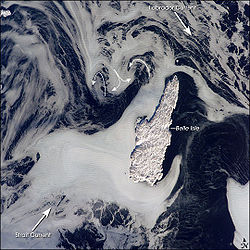
Ice patterns show that the island lies at the meeting point of two sea currents: The Labrador Current
Labrador Current
The Labrador Current is a cold current in the North Atlantic Ocean which flows from the Arctic Ocean south along the coast of Labrador and passes around Newfoundland, continuing south along the east coast of Nova Scotia...
flows from the northwest, and a smaller current, driven by dominant westerly winds, flows from the southwest. Flow lines in sea ice
Sea ice
Sea ice is largely formed from seawater that freezes. Because the oceans consist of saltwater, this occurs below the freezing point of pure water, at about -1.8 °C ....
give a sense of the movement of the ice. Ice floes embedded in the Labrador Current
Labrador Current
The Labrador Current is a cold current in the North Atlantic Ocean which flows from the Arctic Ocean south along the coast of Labrador and passes around Newfoundland, continuing south along the east coast of Nova Scotia...
appear as a relatively open pattern. Sea ice with a denser pattern enters from the strait, banking against the west side of Belle Isle. Tendrils flow around capes at either end of the island, with an ice-free "shadow" on the opposite, downstream side. Eddies off the western coast in the ice patterns (indicated by curved arrows in the photo) show where the currents interact north and west of the island.
The island was named by French explorer Jacques Cartier
Jacques Cartier
Jacques Cartier was a French explorer of Breton origin who claimed what is now Canada for France. He was the first European to describe and map the Gulf of Saint Lawrence and the shores of the Saint Lawrence River, which he named "The Country of Canadas", after the Iroquois names for the two big...
.
External links
- Strait of Belle Isle ecoregion
- http://www.heritage.nf.ca/exploration/chbelle_isle_500.htmlChart of The Strait of Belle Isle and Belle Isle by Captain James CookJames CookCaptain James Cook, FRS, RN was a British explorer, navigator and cartographer who ultimately rose to the rank of captain in the Royal Navy...
]