
Baxter Springs, Kansas
Encyclopedia
Town
A town is a human settlement larger than a village but smaller than a city. The size a settlement must be in order to be called a "town" varies considerably in different parts of the world, so that, for example, many American "small towns" seem to British people to be no more than villages, while...
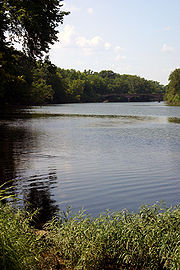
situated along the Spring River
Spring River (Missouri)
The Spring River is a waterway located in southwestern Missouri, southeastern Kansas, and northeastern Oklahoma. It begins in northern Barry County, Missouri south of Aurora, flows north of Verona and turns west across Lawrence and Jasper counties, passing through Carthage, before crossing into...
in the extreme southeastern part of Cherokee County
Cherokee County, Kansas
Cherokee County is a county located in Southeast Kansas, in the Central United States. As of the 2010 census, the county population was 21,603. Its county seat is Columbus, and its most populous city is Baxter Springs...
, located in southeast Kansas
Kansas
Kansas is a US state located in the Midwestern United States. It is named after the Kansas River which flows through it, which in turn was named after the Kansa Native American tribe, which inhabited the area. The tribe's name is often said to mean "people of the wind" or "people of the south...
, in the Central
Central United States
The Central United States is sometimes conceived as between the Eastern United States and Western United States as part of a three-region model, roughly coincident with the Midwestern United States plus the western and central portions of the Southern United States; the term is also sometimes used...
United States
United States
The United States of America is a federal constitutional republic comprising fifty states and a federal district...
. As of the 2010 census, the city population was 4,238. It is the most populous city of Cherokee County.
After the American Civil War
American Civil War
The American Civil War was a civil war fought in the United States of America. In response to the election of Abraham Lincoln as President of the United States, 11 southern slave states declared their secession from the United States and formed the Confederate States of America ; the other 25...
, in the late 1860s, the town developed as one of the first "cow towns" in Kansas, where thousands of heads of Texas
Texas
Texas is the second largest U.S. state by both area and population, and the largest state by area in the contiguous United States.The name, based on the Caddo word "Tejas" meaning "friends" or "allies", was applied by the Spanish to the Caddo themselves and to the region of their settlement in...
cattle were driven to market. It was a stopping place on their way to northern markets.
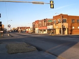
Baxter Springs downtown main street is part of the historic U.S. Route 66
U.S. Route 66
U.S. Route 66 was a highway within the U.S. Highway System. One of the original U.S. highways, Route 66 was established on November 11, 1926 -- with road signs erected the following year...
that passes through Kansas, established in 1926 and connecting Chicago
Chicago
Chicago is the largest city in the US state of Illinois. With nearly 2.7 million residents, it is the most populous city in the Midwestern United States and the third most populous in the US, after New York City and Los Angeles...
and Los Angeles
Los Ángeles
Los Ángeles is the capital of the province of Biobío, in the commune of the same name, in Region VIII , in the center-south of Chile. It is located between the Laja and Biobío rivers. The population is 123,445 inhabitants...
. For decades it was the Main Street of this part of the United States.
History
For thousands of years, indigenous peoplesIndigenous peoples
Indigenous peoples are ethnic groups that are defined as indigenous according to one of the various definitions of the term, there is no universally accepted definition but most of which carry connotations of being the "original inhabitants" of a territory....
had lived along the waterways throughout the west. The Osage
Osage Nation
The Osage Nation is a Native American Siouan-language tribe in the United States that originated in the Ohio River valley in present-day Kentucky. After years of war with invading Iroquois, the Osage migrated west of the Mississippi River to their historic lands in present-day Arkansas, Missouri,...
migrated west from the Ohio River
Ohio River
The Ohio River is the largest tributary, by volume, of the Mississippi River. At the confluence, the Ohio is even bigger than the Mississippi and, thus, is hydrologically the main stream of the whole river system, including the Allegheny River further upstream...
area of Kentucky
Kentucky
The Commonwealth of Kentucky is a state located in the East Central United States of America. As classified by the United States Census Bureau, Kentucky is a Southern state, more specifically in the East South Central region. Kentucky is one of four U.S. states constituted as a commonwealth...
, driven out by the Iroquois
Iroquois
The Iroquois , also known as the Haudenosaunee or the "People of the Longhouse", are an association of several tribes of indigenous people of North America...
. They settled in Kansas by the mid-17th century and competed with other tribes. By 1750 they dominated much of the region of Kansas, Missouri
Missouri
Missouri is a US state located in the Midwestern United States, bordered by Iowa, Illinois, Kentucky, Tennessee, Arkansas, Oklahoma, Kansas and Nebraska. With a 2010 population of 5,988,927, Missouri is the 18th most populous state in the nation and the fifth most populous in the Midwest. It...
and Oklahoma
Oklahoma
Oklahoma is a state located in the South Central region of the United States of America. With an estimated 3,751,351 residents as of the 2010 census and a land area of 68,667 square miles , Oklahoma is the 28th most populous and 20th-largest state...
. One of the largest Osage bands in present-day Oklahoma, led by Chief Black Dog (Manka - Chonka), made the Black Dog Trail before 1800. It started from their winter territory east of Baxter Springs and extended northwest to their hunting grounds at the Great Salt Plains
Salt Plains National Wildlife Refuge
The Salt Plains National Wildlife Refuge is part of the United States system of National Wildlife Refuges. It is located in Alfalfa County in northern Oklahoma, north of Jet The Salt Plains National Wildlife Refuge is part of the United States system of National Wildlife Refuges. It is located in...
in present-day Alfalfa County, Oklahoma
Alfalfa County, Oklahoma
Alfalfa County is a county located in the U.S. state of Oklahoma. As of 2000, the population is 6,105. Its county seat is Cherokee. Alfalfa County was formed in 1907 from Woods County. The county is named after William H...
. The Osage stopped at the springs for healing on their way to summer hunting grounds. They cleared the trail of brush and large rocks, and made ramps to the fords. Wide enough for eight horsemen to ride abreast, the trail was the first improved road in Kansas and Oklahoma.
During the American Civil War
American Civil War
The American Civil War was a civil war fought in the United States of America. In response to the election of Abraham Lincoln as President of the United States, 11 southern slave states declared their secession from the United States and formed the Confederate States of America ; the other 25...
, the United States government built several military posts at present-day Baxter Springs, fortifying what had been a trading post: Fort Baxter
Fort Baxter (Kansas)
Fort Baxter, also known as Fort Blair, was a small US Army post located in the southeast corner of Kansas near present-day Baxter Springs, Kansas. This was known as the Cherokee Strip. It was one of a few Kansas forts attacked by Confederate forces...
, Camp Ben Butler
Camp Ben Butler
In early May 1863 a temporary camp, Camp Hooker, was established at the site of what later became Baxter Springs, Kansas. This area was located in what was known as the Cherokee Strip . In late May while the camp commander, Col. James M. Williams, was in Fort Scott, the troops moved the camp...
and Camp Hunter
Camp Hunter
Camp Hunter was established in June 1862 or a bit earlier at what is now Baxter Springs, Kansas. It was established by Union troops. At the same time Indian Home Guard regiments established a camp nearby on Little Five Mile Creek....
. In October 1863 Confederate forces attacked Fort Baxter in the Battle of Baxter Springs
Battle of Baxter Springs
The Battle of Fort Blair, sometimes called the Fort Baxter Massacre, or the Battle of Fort Baxter was a minor battle of the American Civil War, fought on October 6, 1863, near the present-day town of Baxter Springs, Kansas....
.
The town had a cable ferry
Cable ferry
A cable ferry is guided and in many cases propelled across a river or other larger body of water by cables connected to both shores. They are also called chain ferries, floating bridges, or punts....
in use by 1867, which operated into the 1880s, when a bridge was built across the Spring River. Expansion of European-American cattle ranching led to the growth of Baxter Springs as the first cow town in Kansas. Around 1868 there was a great demand for beef in the North
The North
The North may refer to:* a geographical section of the world * the wealthy and technologically advanced nations of the world, as contrasted with the nations comprising the South...
. Texas
Texas
Texas is the second largest U.S. state by both area and population, and the largest state by area in the contiguous United States.The name, based on the Caddo word "Tejas" meaning "friends" or "allies", was applied by the Spanish to the Caddo themselves and to the region of their settlement in...
cattlemen and stock raisers drove large herds of cattle from the southern plains, and used Baxter Springs as a way point to the northern markets linking to railroads to the East. The town organized the Stockyards and Drovers Association to buy and sell cattle. They constructed corrals for up to 20,000 head of cattle, supplied with ample grazing lands and fresh water. Texas cattle trade stimulated the growth of related businesses, and Baxter Springs grew rapidly. At the same time that settlers were building schools and churches, the town was the rowdy gathering place of cowboys, with saloons, livery stables and hotels to support the seasonal business.
When Texas constructed railroads later in the century, cattlemen no longer needed Baxter Springs as a way station to the northern markets. The town had to create a new economy and became more limited as a regional trading center. In 1926 the downtown main street became part of the historic Route 66
U.S. Route 66
U.S. Route 66 was a highway within the U.S. Highway System. One of the original U.S. highways, Route 66 was established on November 11, 1926 -- with road signs erected the following year...
transcontinental highway connecting Chicago and Los Angeles. The designated highway was informally known as America's "Main Street" and had a prominent place in popular culture.
Geography
Baxter Springs is located at 37°1′23"N 94°44′5"W (37.023062, -94.734762). The city is situated along the western bank of the Spring RiverSpring River (Missouri)
The Spring River is a waterway located in southwestern Missouri, southeastern Kansas, and northeastern Oklahoma. It begins in northern Barry County, Missouri south of Aurora, flows north of Verona and turns west across Lawrence and Jasper counties, passing through Carthage, before crossing into...
at the edge of the Ozarks
The Ozarks
The Ozarks are a physiographic and geologic highland region of the central United States. It covers much of the southern half of Missouri and an extensive portion of northwestern and north central Arkansas...
. It is at the junction of U.S. Route 69
U.S. Route 69
U.S. Route 69 is a north–south United States highway. When it was first created, it was only long, but it has since been expanded into a Minnesota to Texas cross-country route. The highway's southern terminus is in Port Arthur, Texas at an intersection with State Highway 87...
Alternate and U.S. Route 166
U.S. Route 166
U.S. Route 166 is an east–west United States highway. This route and US-266 are the only two remaining spurs of historic U.S. Highway 66, since US-666 was renumbered in 2003....
, and U.S. Route 400
U.S. Route 400
U.S. Route 400 is a mostly east–west U.S. Highway, commissioned in 1994. Its route number is a "violation" of the usual AASHTO numbering scheme, as there is no US 0 or US 100....
bypasses the city to the northeast. The center of town is less than two miles (3 km) from the Kansas
Kansas
Kansas is a US state located in the Midwestern United States. It is named after the Kansas River which flows through it, which in turn was named after the Kansa Native American tribe, which inhabited the area. The tribe's name is often said to mean "people of the wind" or "people of the south...
-Oklahoma
Oklahoma
Oklahoma is a state located in the South Central region of the United States of America. With an estimated 3,751,351 residents as of the 2010 census and a land area of 68,667 square miles , Oklahoma is the 28th most populous and 20th-largest state...
state border though the incorporated area of the city extends to the border. It is also about 13 miles (20.9 km) west-southwest of Joplin
Joplin, Missouri
Joplin is a city in southern Jasper County and northern Newton County in the southwestern corner of the US state of Missouri. Joplin is the largest city in Jasper County, though it is not the county seat. As of the 2010 census, the city population was 50,150...
, Missouri
Missouri
Missouri is a US state located in the Midwestern United States, bordered by Iowa, Illinois, Kentucky, Tennessee, Arkansas, Oklahoma, Kansas and Nebraska. With a 2010 population of 5,988,927, Missouri is the 18th most populous state in the nation and the fifth most populous in the Midwest. It...
.
According to the United States Census Bureau
United States Census Bureau
The United States Census Bureau is the government agency that is responsible for the United States Census. It also gathers other national demographic and economic data...
, the city has a total area of 3.2 square miles (8.3 km²), of which 3.1 sq mi (8 km²). (8.1 km²) is land and 0.1 sq mi (0.258998811 km²). (0.2 km²), or 2.48%, is water.
Demographics
As of the census of 2000United States Census, 2000
The Twenty-second United States Census, known as Census 2000 and conducted by the Census Bureau, determined the resident population of the United States on April 1, 2000, to be 281,421,906, an increase of 13.2% over the 248,709,873 persons enumerated during the 1990 Census...
, there were 4,602 people, 1,860 households, and 1,246 families residing in the city. The population density
Population density
Population density is a measurement of population per unit area or unit volume. It is frequently applied to living organisms, and particularly to humans...
was 1,469.1 people per square mile (567.7/km²). There were 2,106 housing units at an average density of 672.3 per square mile (259.8/km²). The racial makeup of the city was 88.03% White, 0.98% Black or African American, 5.04% Native American, 0.20% Asian, 0.17% Pacific Islander, 0.48% from other races, and 5.11% from two or more races
Multiracial
The terms multiracial and mixed-race describe people whose ancestries come from multiple races. Unlike the term biracial, which often is only used to refer to having parents or grandparents of two different races, the term multiracial may encompass biracial people but can also include people with...
. Hispanic or Latino of any race were 1.30% of the population.
There were 1,860 household
Household
The household is "the basic residential unit in which economic production, consumption, inheritance, child rearing, and shelter are organized and carried out"; [the household] "may or may not be synonymous with family"....
s out of which 32.2% had children under the age of 18 living with them, 52.6% were married couples
Marriage
Marriage is a social union or legal contract between people that creates kinship. It is an institution in which interpersonal relationships, usually intimate and sexual, are acknowledged in a variety of ways, depending on the culture or subculture in which it is found...
living together, 10.4% had a female householder with no husband present, and 33.0% were non-families. 29.7% of all households were made up of individuals and 16.6% had someone living alone who was 65 years of age or older. The average household size was 2.44 and the average family size was 3.02.
In the city the population was spread out with 26.5% under the age of 18, 9.2% from 18 to 24, 26.7% from 25 to 44, 20.8% from 45 to 64, and 16.7% who were 65 years of age or older. The median age was 36 years. For every 100 females there were 89.5 males. For every 100 females age 18 and over, there were 85.4 males.
The median income for a household
Median household income
The median household income is commonly used to generate data about geographic areas and divides households into two equal segments with the first half of households earning less than the median household income and the other half earning more...
in the city was $28,876, and the median income for a family was $33,933. Males had a median income of $27,005 versus $19,038 for females. The per capita income
Per capita income
Per capita income or income per person is a measure of mean income within an economic aggregate, such as a country or city. It is calculated by taking a measure of all sources of income in the aggregate and dividing it by the total population...
for the city was $13,789. About 9.3% of families and 10.2% of the population were below the poverty line, including 13.5% of those under age 18 and 12.4% of those age 65 or over.
Notable people
- Hale IrwinHale IrwinHale S. Irwin is an American professional golfer. He is one of the few players in history to have won three U.S. Opens and was one of the world's leading golfers for much of the 1970s and 1980s. He has also developed a career as a golf course architect.Irwin was born in Joplin, Missouri, but was...
, (born 1945), PGAProfessional Golfers AssociationProfessional Golfers' Association, , is the usual term for a professional association in men's golf. It is often abbreviated to PGA...
golfer - Joe Don Rooney, (born 1975), lead guitarist for country pop trio Rascal FlattsRascal FlattsRascal Flatts is an American country music band that originated in Columbus, Ohio, United States of America. Since its inception, Rascal Flatts has been composed of three members: Gary LeVox , Jay DeMarcus and Joe Don Rooney...
- H. Lee Scott, Jr., (born 1949), former President and CEO of Wal-Mart.
External links
City- City of Baxter Springs
- Baxter Springs - Directory of Public Officials
- Baxter Springs Heritage Center and Museum
Maps
- 2008 Baxter Springs City Map, KDOT
- 2011 Cherokee County Map, KDOT