

Bass River (Massachusetts)
Encyclopedia
Estuary
An estuary is a partly enclosed coastal body of water with one or more rivers or streams flowing into it, and with a free connection to the open sea....
and village
Village
A village is a clustered human settlement or community, larger than a hamlet with the population ranging from a few hundred to a few thousand , Though often located in rural areas, the term urban village is also applied to certain urban neighbourhoods, such as the West Village in Manhattan, New...
in South Yarmouth, Massachusetts
Massachusetts
The Commonwealth of Massachusetts is a state in the New England region of the northeastern United States of America. It is bordered by Rhode Island and Connecticut to the south, New York to the west, and Vermont and New Hampshire to the north; at its east lies the Atlantic Ocean. As of the 2010...
, United States
United States
The United States of America is a federal constitutional republic comprising fifty states and a federal district...
. The estuary separates the towns of Yarmouth
Yarmouth, Massachusetts
Yarmouth is a New England town in Barnstable County, Massachusetts, United States, Barnstable County being coextensive with Cape Cod. The population was 24,807 at the 2000 census....
and Dennis
Dennis, Massachusetts
Dennis is a town in Barnstable County, Massachusetts, United States; located near the center of Cape Cod. The population was 14,207 at the 2010 census.The town encompasses five distinct villages, each of which has its own post office...
at the central, southern sections of the towns. At its widest and most southerly point, it opens to and meets Nantucket Sound
Nantucket Sound
Nantucket Sound is a roughly triangular area of the Atlantic Ocean offshore from the U.S. state of Massachusetts. It is long and wide, and is enclosed by Cape Cod on the north, Nantucket on the south, and Martha's Vineyard on the west. Between Cape Cod and Martha's Vineyard it is connected to the...
. Its brackish, northwestern end flows into Follins Pond
Follins Pond
Follins Pond is a brackish lake located on Cape Cod, separating the towns of Dennis, Massachusetts, and Yarmouth, Massachusetts. The lake is connected to Nantucket Sound via the Bass River.-Connection to Vinland:...
, from there winding further north as a brook
Stream
A stream is a body of water with a current, confined within a bed and stream banks. Depending on its locale or certain characteristics, a stream may be referred to as a branch, brook, beck, burn, creek, "crick", gill , kill, lick, rill, river, syke, bayou, rivulet, streamage, wash, run or...
, to Mill Pond then an underground stream that nearly bisects Cape Cod
Cape Cod
Cape Cod, often referred to locally as simply the Cape, is a cape in the easternmost portion of the state of Massachusetts, in the Northeastern United States...
.
The mouth of the river is between Smugglers Beach on the Yarmouth side and West Dennis Beach on the Dennis side. West Dennis beach has become a popular site for kite boarding
Kite boarding
Kite boarding is a sport based on kitesurfing and snowboarding. It involves the use of a snowboard, with the most obsessed riders buying or building slightly modified snowboards for greater impacts, creating, essentially, a sturdy snowboard, as well as the use of a kite similar to the kite used in...
in the past few years. In the same way Kalmus Beach in Hyannis
Hyannis
Hyannis may refer to a location in the United States:* Hyannis, Massachusetts* Hyannisport, Massachusetts* Hyannis, Nebraska...
has become popular for windsurfing
Windsurfing
Windsurfing or sailboarding is a surface water sport that combines elements of surfing and sailing. It consists of a board usually two to four metres long, powered by the orthogonal effect of the wind on a sail. The rig is connected to the board by a free-rotating universal joint and comprises a...
. Once inside the river, there is a large land mass covered with sea grass in the middle of which is a large bay
Bay
A bay is an area of water mostly surrounded by land. Bays generally have calmer waters than the surrounding sea, due to the surrounding land blocking some waves and often reducing winds. Bays also exist as an inlet in a lake or pond. A large bay may be called a gulf, a sea, a sound, or a bight...
. The island is called 'Marsh Island' by the locals.
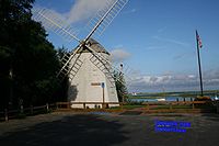
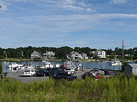
Marsh Island separates Bass River into two parts. The right side of the river, which is referred as the 'Old Field Channel' goes towards West Dennis and the Fingers development. The left side is the main channel of the river passing Windmill Beach, Bass River Yacht Club, Ship Shops Marina and the prestigious Bass River Marina and Yacht Club. After the marina, the river goes under the Route 28 bridge and winds 5 more miles deep into the cape. Bass River was once considered a viable location for a canal
Canal
Canals are man-made channels for water. There are two types of canal:#Waterways: navigable transportation canals used for carrying ships and boats shipping goods and conveying people, further subdivided into two kinds:...
traversing Cape Cod and is the largest river the Mid-Cape Highway spans.
Bass River is home to a friendly rivalry between West Dennis Yacht Club and the Bass River Yacht Club. These clubs also compete against Hyannis Yacht Club, Wianno Yacht Club, and others in the Southern Massachusetts Sailing Association team racing circuit. The Yarmouth shores are home to Bass River Golf Course, which is owned and operated by the town of Yarmouth.
There is another tidal inlet known as the Bass River in the city of Beverly
Beverly, Massachusetts
Beverly is a city in Essex County, Massachusetts, United States. The population was 39,343 on , which differs by no more than several hundred from the 39,862 obtained in the 2000 census. A resort, residential and manufacturing community on the North Shore, Beverly includes Beverly Farms and Prides...
.