
Dennis, Massachusetts
Encyclopedia
Dennis is a town
in Barnstable County
, Massachusetts
, United States
; located near the center of Cape Cod
. The population was 14,207 at the 2010 census.
The town encompasses five distinct villages, each of which has its own post office
. These constituent villages are Dennis
(including North Dennis), Dennis Port
, East Dennis
, South Dennis
, and West Dennis
.
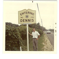
. The town officially separated and incorporated in 1793. It was named after resident minister, Josiah Dennis. There was not enough land for farming, so seafaring became the town's major industry in its early history, centered around the Shiverick Shipyard.
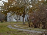
Currently, Dennis is a popular seaside resort town, notable for its stately colonial mansions along the northern Cape Cod Bay
coastline, and its picturesque, warm water beaches along the southern Nantucket Sound
.
The Cape Playhouse, in northern Dennis, is the oldest summer theatre in the United States, and among the best known. The actress Bette Davis
was 'discovered' there while working there as an usher. Other famous Dennis residents include the author Mary Higgins Clark
and actress Amy Jo Johnson
, who grew up in Dennis.
 According to the United States Census Bureau
, the town has a total area of 22.2 square miles (57.5 km²), of which, 20.6 square miles (53.4 km²) of it is land and 1.6 square miles (4.1 km²) of it (7.38%) is water.
The town of Dennis spans the width of Cape Cod
, with Cape Cod Bay
to the north, Brewster
to the northeast, Harwich
to the southeast, Nantucket Sound
to the south, and Yarmouth
to the west. The town is about ten miles (16 km) east of Barnstable
, twenty-four miles east of the Sagamore Bridge
, and seventy-eight miles southeast of Boston. The Town of Dennis comprises the villages of Dennis Port, Dennis Village (including North Dennis), East Dennis, South Dennis and West Dennis.
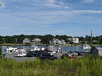
The town lies on the eastern banks of the Bass River, which nearly divides the cape in half. There are several small ponds and lakes in town, as well as Sesuit Harbor to the north and West Dennis Harbor to the south.
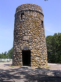
The area of Scargo Lake and Scargo Hill in Dennis are associated with ancient Native American folklore. The legend of the lake's creation was the inspiration for a children's book and an American folklore tale, the Legend of Scargo. When viewed from the tower atop Scargo Hill, Scargo lake appears to be in the shape of a fish.
Both the north and south shores have many beaches, as well as the Dennis Yacht Club in the north and West Dennis Yacht Club in the south.
While West Dennis is indeed west of Dennisport, it is south of South Dennis. East Dennis is north of South Dennis, and Dennis is on the western shore, to the west of East Dennis.
of 2000, there were 15,973 people, 7,504 households, and 4,577 families residing in the town. The census measures the year-round population; in the summer the population is estimated to be 63,000. The census population density
was 775.6 PD/sqmi. There were 14,105 housing units at an average density of 684.9 /sqmi. The racial makeup of the town was 94.99% White, 1.93% Black or African American
, 0.37% Native American, 0.37% Asian, 0.88% from other races
, and 1.46% from two or more races. Hispanic or Latino of any race were 1.65% of the population.
There were 7,504 households out of which 18.8% had children under the age of 18 living with them, 49.0% were married couples
living together, 9.2% had a female householder with no husband present, and 39.0% were non-families. 33.3% of all households were made up of individuals and 17.7% had someone living alone who was 65 years of age or older. The average household size was 2.11 and the average family size was 2.65.
In the town the population was spread out with 16.9% under the age of 18, 4.6% from 18 to 24, 22.2% from 25 to 44, 27.8% from 45 to 64, and 28.4% who were 65 years of age or older. The median age was 49 years. For every 100 females there were 85.6 males. For every 100 females age 18 and over, there were 82.7 males.
The median income for a household in the town was $41,598, and the median income for a family was $50,478. Males had a median income of $40,528 versus $29,153 for females. The per capita income
for the town was $25,428. About 5.4% of families and 7.0% of the population were below the poverty line, including 10.4% of those under age 18 and 4.8% of those age 65 or over.
Southside Beaches Include:
Glendon Beach, Haigis Beach, Inman Road Beach, Maycroft Beach, Metcalfe Memorial Beach, West Dennis Beach, South Village Beach
All the public beaches in Dennis are free to walk on. However, every beach (except those with a *) charges a non-resident parking fee of $20 per day or $75 per week. Residents (Dennis taxpayers) can buy beach parking stickers with proof of residency for $30 for the season.
Resident-only beaches*. Non-residents cannot park here. (Of course in the winter, nobody checks for beach stickers)
Mayflower Beach is a recreational beach in Dennis, Massachusetts. The beach faces Cape Cod Bay and is named after the Pilgrims' ship, The Mayflower.
, Route 6A
and Route 28
, as well as Route 134
, which crosses the town from Route 28 to Route 6A. East of the Route 134 exit, Route 6 (also known as the Mid-Cape Highway) downgrades from a four lane divided highway to a two lane highway, divided only by markers.
The Cape's Bay Colony Rail officially ends in the town. The ending point is also the starting point of the Cape Cod Rail Trail
, a bicycle trail which runs "down" the Cape to Wellfleet
along the former right-of-way of the rail. There are also several other bicycle trails in town. The nearest regional air service can be reached at the Barnstable Municipal Airport
, and the nearest national and international air service can be reached at Logan International Airport
in Boston.
as a part of the First Barnstable Districts. The town is represented in the Massachusetts Senate
as a part of the Cape and Islands Districts, which includes all of Cape Cod, Martha's Vineyard and Nantucket except the towns of Bourne, Falmouth, Sandwich and a portion of Barnstable. The town is patrolled by the Second (Yarmouth) Barracks of Troop D of the Massachusetts State Police
.
On the national level, Dennis is a part of Massachusetts's 10th congressional district
, and is currently represented by William Keating
. The state's senior (Class I) member of the United States Senate
, re-elected in 2008, is John Kerry
. The junior (Class II) Senator, elected January 19, 2010, is Scott Brown
.
The town of Dennis uses the open town meeting
form of government, and is led by an executive secretary and a board of selectmen
. The town has its own police department, and a fire department headquartered near the intersection of Routes 28 and 134 with a branch station off of Route 6A. There are post offices in each of the five villages, as are the town's libraries. The central library is located in Dennis Port, and all are a part of the Cape Libraries Automated Materials Sharing
library network. The town operates its own landfill, located southeast of the junction of Routes 6 and 134.
New England town
The New England town is the basic unit of local government in each of the six New England states. Without a direct counterpart in most other U.S. states, New England towns are conceptually similar to civil townships in other states, but are incorporated, possessing powers like cities in other...
in Barnstable County
Barnstable County, Massachusetts
Barnstable County is a county located in the U.S. state of Massachusetts, consisting of Cape Cod and associated islands. As of the 2010 census, the population was 216,902...
, Massachusetts
Massachusetts
The Commonwealth of Massachusetts is a state in the New England region of the northeastern United States of America. It is bordered by Rhode Island and Connecticut to the south, New York to the west, and Vermont and New Hampshire to the north; at its east lies the Atlantic Ocean. As of the 2010...
, United States
United States
The United States of America is a federal constitutional republic comprising fifty states and a federal district...
; located near the center of Cape Cod
Cape Cod
Cape Cod, often referred to locally as simply the Cape, is a cape in the easternmost portion of the state of Massachusetts, in the Northeastern United States...
. The population was 14,207 at the 2010 census.
The town encompasses five distinct villages, each of which has its own post office
Post office
A post office is a facility forming part of a postal system for the posting, receipt, sorting, handling, transmission or delivery of mail.Post offices offer mail-related services such as post office boxes, postage and packaging supplies...
. These constituent villages are Dennis
Dennis (CDP), Massachusetts
Dennis is a village and census-designated place in the town of Dennis in Barnstable County, Massachusetts, United States. The population was 2,798 at the 2000 census...
(including North Dennis), Dennis Port
Dennis Port, Massachusetts
Dennis Port is a census-designated place in the town of Dennis in Barnstable County, Cape Cod, Massachusetts. At the 2000 census, its population was 3,612....
, East Dennis
East Dennis, Massachusetts
East Dennis is a census-designated place in the town of Dennis in Barnstable County, Massachusetts, United States. The population was 3,299 at the 2000 census.-Geography:East Dennis is located at ....
, South Dennis
South Dennis, Massachusetts
South Dennis is a census-designated place in the town of Dennis in Barnstable County, Massachusetts, United States. The population was 3,679 at the 2000 census.-Geography:South Dennis is located at ....
, and West Dennis
West Dennis, Massachusetts
West Dennis is a census-designated place in the town of Dennis in Barnstable County, Massachusetts, United States. The population was 2,570 at the 2000 census.-Geography:West Dennis is located at ....
.
History
Dennis was first settled in 1639, by John Crowe (later Crowell) and Thomas Howes, as part of the town of YarmouthYarmouth, Massachusetts
Yarmouth is a New England town in Barnstable County, Massachusetts, United States, Barnstable County being coextensive with Cape Cod. The population was 24,807 at the 2000 census....
. The town officially separated and incorporated in 1793. It was named after resident minister, Josiah Dennis. There was not enough land for farming, so seafaring became the town's major industry in its early history, centered around the Shiverick Shipyard.
Currently, Dennis is a popular seaside resort town, notable for its stately colonial mansions along the northern Cape Cod Bay
Cape Cod Bay
Cape Cod Bay is a large bay of the Atlantic Ocean adjacent to the U.S. state of Massachusetts. Measuring below a line drawn from Brant Rock in Marshfield to Race Point in Provincetown, Massachusetts, it is enclosed by Cape Cod to the south and east, and Plymouth County, Massachusetts, to the west....
coastline, and its picturesque, warm water beaches along the southern Nantucket Sound
Nantucket Sound
Nantucket Sound is a roughly triangular area of the Atlantic Ocean offshore from the U.S. state of Massachusetts. It is long and wide, and is enclosed by Cape Cod on the north, Nantucket on the south, and Martha's Vineyard on the west. Between Cape Cod and Martha's Vineyard it is connected to the...
.
The Cape Playhouse, in northern Dennis, is the oldest summer theatre in the United States, and among the best known. The actress Bette Davis
Bette Davis
Ruth Elizabeth "Bette" Davis was an American actress of film, television and theater. Noted for her willingness to play unsympathetic characters, she was highly regarded for her performances in a range of film genres, from contemporary crime melodramas to historical and period films and occasional...
was 'discovered' there while working there as an usher. Other famous Dennis residents include the author Mary Higgins Clark
Mary Higgins Clark
Mary Theresa Eleanor Higgins Clark Conheeney , known professionally as Mary Higgins Clark, is an American author of suspense novels...
and actress Amy Jo Johnson
Amy Jo Johnson
Amy Jo Johnson is an American actress, singer, songwriter and musician.She is best known for her roles in the televison series as the constable Jules Callaghan in the Canadian CTV television series Flashpoint, the famous jockey Tina Sharp in the ABC Family's original show Wildfire, the rookie cop...
, who grew up in Dennis.
Geography
United States Census Bureau
The United States Census Bureau is the government agency that is responsible for the United States Census. It also gathers other national demographic and economic data...
, the town has a total area of 22.2 square miles (57.5 km²), of which, 20.6 square miles (53.4 km²) of it is land and 1.6 square miles (4.1 km²) of it (7.38%) is water.
The town of Dennis spans the width of Cape Cod
Cape Cod
Cape Cod, often referred to locally as simply the Cape, is a cape in the easternmost portion of the state of Massachusetts, in the Northeastern United States...
, with Cape Cod Bay
Cape Cod Bay
Cape Cod Bay is a large bay of the Atlantic Ocean adjacent to the U.S. state of Massachusetts. Measuring below a line drawn from Brant Rock in Marshfield to Race Point in Provincetown, Massachusetts, it is enclosed by Cape Cod to the south and east, and Plymouth County, Massachusetts, to the west....
to the north, Brewster
Brewster, Massachusetts
Brewster is a town in Barnstable County, Massachusetts, United States, Barnstable County being coextensive with Cape Cod. The population of Brewster was 9,820 at the 2010 census.Brewster is twinned with the town of Budleigh Salterton in the United Kingdom....
to the northeast, Harwich
Harwich, Massachusetts
Harwich is a New England town on Cape Cod, in Barnstable County in the state of Massachusetts in the United States. Barnstable County is coextensive with Cape Cod. The town is a popular vacation spot, located near the Cape Cod National Seashore. Harwich's beaches are on "the Sound side" of Cape...
to the southeast, Nantucket Sound
Nantucket Sound
Nantucket Sound is a roughly triangular area of the Atlantic Ocean offshore from the U.S. state of Massachusetts. It is long and wide, and is enclosed by Cape Cod on the north, Nantucket on the south, and Martha's Vineyard on the west. Between Cape Cod and Martha's Vineyard it is connected to the...
to the south, and Yarmouth
Yarmouth, Massachusetts
Yarmouth is a New England town in Barnstable County, Massachusetts, United States, Barnstable County being coextensive with Cape Cod. The population was 24,807 at the 2000 census....
to the west. The town is about ten miles (16 km) east of Barnstable
Barnstable, Massachusetts
Barnstable is a city, referred to as the Town of Barnstable, in the U.S. state of Massachusetts and the county seat of Barnstable County. Barnstable is the largest community, both in land area and population, on Cape Cod. The town contains seven villages within its boundaries...
, twenty-four miles east of the Sagamore Bridge
Sagamore Bridge
The Sagamore Bridge in Sagamore, Massachusetts carries U.S. Route 6 across the Cape Cod Canal, connecting Cape Cod with the rest of Massachusetts, USA....
, and seventy-eight miles southeast of Boston. The Town of Dennis comprises the villages of Dennis Port, Dennis Village (including North Dennis), East Dennis, South Dennis and West Dennis.
The town lies on the eastern banks of the Bass River, which nearly divides the cape in half. There are several small ponds and lakes in town, as well as Sesuit Harbor to the north and West Dennis Harbor to the south.
The area of Scargo Lake and Scargo Hill in Dennis are associated with ancient Native American folklore. The legend of the lake's creation was the inspiration for a children's book and an American folklore tale, the Legend of Scargo. When viewed from the tower atop Scargo Hill, Scargo lake appears to be in the shape of a fish.
Both the north and south shores have many beaches, as well as the Dennis Yacht Club in the north and West Dennis Yacht Club in the south.
While West Dennis is indeed west of Dennisport, it is south of South Dennis. East Dennis is north of South Dennis, and Dennis is on the western shore, to the west of East Dennis.
Demographics
As of the censusCensus
A census is the procedure of systematically acquiring and recording information about the members of a given population. It is a regularly occurring and official count of a particular population. The term is used mostly in connection with national population and housing censuses; other common...
of 2000, there were 15,973 people, 7,504 households, and 4,577 families residing in the town. The census measures the year-round population; in the summer the population is estimated to be 63,000. The census population density
Population density
Population density is a measurement of population per unit area or unit volume. It is frequently applied to living organisms, and particularly to humans...
was 775.6 PD/sqmi. There were 14,105 housing units at an average density of 684.9 /sqmi. The racial makeup of the town was 94.99% White, 1.93% Black or African American
Race (United States Census)
Race and ethnicity in the United States Census, as defined by the Federal Office of Management and Budget and the United States Census Bureau, are self-identification data items in which residents choose the race or races with which they most closely identify, and indicate whether or not they are...
, 0.37% Native American, 0.37% Asian, 0.88% from other races
Race (United States Census)
Race and ethnicity in the United States Census, as defined by the Federal Office of Management and Budget and the United States Census Bureau, are self-identification data items in which residents choose the race or races with which they most closely identify, and indicate whether or not they are...
, and 1.46% from two or more races. Hispanic or Latino of any race were 1.65% of the population.
There were 7,504 households out of which 18.8% had children under the age of 18 living with them, 49.0% were married couples
Marriage
Marriage is a social union or legal contract between people that creates kinship. It is an institution in which interpersonal relationships, usually intimate and sexual, are acknowledged in a variety of ways, depending on the culture or subculture in which it is found...
living together, 9.2% had a female householder with no husband present, and 39.0% were non-families. 33.3% of all households were made up of individuals and 17.7% had someone living alone who was 65 years of age or older. The average household size was 2.11 and the average family size was 2.65.
In the town the population was spread out with 16.9% under the age of 18, 4.6% from 18 to 24, 22.2% from 25 to 44, 27.8% from 45 to 64, and 28.4% who were 65 years of age or older. The median age was 49 years. For every 100 females there were 85.6 males. For every 100 females age 18 and over, there were 82.7 males.
The median income for a household in the town was $41,598, and the median income for a family was $50,478. Males had a median income of $40,528 versus $29,153 for females. The per capita income
Per capita income
Per capita income or income per person is a measure of mean income within an economic aggregate, such as a country or city. It is calculated by taking a measure of all sources of income in the aggregate and dividing it by the total population...
for the town was $25,428. About 5.4% of families and 7.0% of the population were below the poverty line, including 10.4% of those under age 18 and 4.8% of those age 65 or over.
Beaches
All the public beaches in Dennis are owned by the town. The Northside Beaches are located on Cape Cod Bay, while Southside Beaches are located on Nantucket Sound. Some of them have different names for different entrances. On the Northside, Corporation Beach and Howes Street Beach are on the same strip of public beach. The same goes for Mayflower Beach and Bayview* Beach, and Cold Storage* Beach and Sea Street Beach. Chapin Beach and Harborview* Beach are not paired with any other. On the Northside, the town also owns two beaches on Scargo Lake which are Scargo Beach and Princess Beach.Southside Beaches Include:
Glendon Beach, Haigis Beach, Inman Road Beach, Maycroft Beach, Metcalfe Memorial Beach, West Dennis Beach, South Village Beach
All the public beaches in Dennis are free to walk on. However, every beach (except those with a *) charges a non-resident parking fee of $20 per day or $75 per week. Residents (Dennis taxpayers) can buy beach parking stickers with proof of residency for $30 for the season.
Resident-only beaches*. Non-residents cannot park here. (Of course in the winter, nobody checks for beach stickers)
Mayflower Beach is a recreational beach in Dennis, Massachusetts. The beach faces Cape Cod Bay and is named after the Pilgrims' ship, The Mayflower.
Transportation
Dennis is crossed from east to west by Cape Cod's three main routes, U.S. Route 6U.S. Route 6
U.S. Route 6 , also called the Grand Army of the Republic Highway, a name that honors an American Civil War veterans association, is a main route of the U.S. Highway system, running east-northeast from Bishop, California to Provincetown, Massachusetts. Until 1964, it continued south from Bishop to...
, Route 6A
Route 6A (Massachusetts)
Route 6A is the name for parts of former U.S. Route 6 on Cape Cod. Most of "6A", as the locals call it, is also known as the Old King's Highway...
and Route 28
Route 28 (Massachusetts)
Route 28 is a nominally south–north route in the U.S. state of Massachusetts, running from the town of Orleans via Boston to the New Hampshire state line in Methuen. Following the route from its nominally southern end, Route 28 initially heads south to the town of Chatham then turns west to...
, as well as Route 134
Route 134 (Massachusetts)
Route 134 is a north–south highway entirely within the town of Dennis on Cape Cod. It is slightly over in length and has a full cloverleaf interchange at U.S. Route 6 . Except for its termini, Route 134 is almost entirely located within the village of South Dennis.-History:This highway has...
, which crosses the town from Route 28 to Route 6A. East of the Route 134 exit, Route 6 (also known as the Mid-Cape Highway) downgrades from a four lane divided highway to a two lane highway, divided only by markers.
The Cape's Bay Colony Rail officially ends in the town. The ending point is also the starting point of the Cape Cod Rail Trail
Cape Cod Rail Trail
The Cape Cod Rail Trail is a paved rail trail located on Cape Cod in Massachusetts.Operated by the Massachusetts Department of Conservation and Recreation, it occupies an abandoned Old Colony Railroad corridor and extends from Route 134 in South Dennis to LeCount Hollow Road in South Wellfleet.Its...
, a bicycle trail which runs "down" the Cape to Wellfleet
Wellfleet, Massachusetts
Wellfleet is a New England town in Barnstable County, Massachusetts, United States. Located halfway between the "tip" and "elbow" of Cape Cod, Massachusetts, the town had a population of 2,749 at the 2000 census, which swells nearly sixfold during the summer...
along the former right-of-way of the rail. There are also several other bicycle trails in town. The nearest regional air service can be reached at the Barnstable Municipal Airport
Barnstable Municipal Airport
Barnstable Municipal Airport , also known as Boardman/Polando Field, is a public airport located on Cape Cod, one mile north of the central business district of Hyannis, in Barnstable County, Massachusetts, United States. This airport is publicly owned by Town of Barnstable...
, and the nearest national and international air service can be reached at Logan International Airport
Logan International Airport
General Edward Lawrence Logan International Airport is located in the East Boston neighborhood of Boston, Massachusetts . It covers , has six runways, and employs an estimated 16,000 people. It is the 19th busiest airport in the United States.Boston serves as a focus city for JetBlue Airways...
in Boston.
Government
Dennis is represented in the Massachusetts House of RepresentativesMassachusetts House of Representatives
The Massachusetts House of Representatives is the lower house of the Massachusetts General Court, the state legislature of the Commonwealth of Massachusetts. It is composed of 160 members elected from single-member electoral districts across the Commonwealth. Representatives serve two-year terms...
as a part of the First Barnstable Districts. The town is represented in the Massachusetts Senate
Massachusetts Senate
The Massachusetts Senate is the upper house of the Massachusetts General Court, the bicameral state legislature of the Commonwealth of Massachusetts. The Senate comprises 40 elected members from 40 single-member senatorial districts in the state...
as a part of the Cape and Islands Districts, which includes all of Cape Cod, Martha's Vineyard and Nantucket except the towns of Bourne, Falmouth, Sandwich and a portion of Barnstable. The town is patrolled by the Second (Yarmouth) Barracks of Troop D of the Massachusetts State Police
Massachusetts State Police
The Massachusetts State Police is an agency of the Commonwealth of Massachusetts' Executive Office of Public Safety and Security responsible for criminal law enforcement and traffic vehicle regulation across the state...
.
On the national level, Dennis is a part of Massachusetts's 10th congressional district
Massachusetts's 10th congressional district
Massachusetts's 10th congressional district is a political constituency that includes parts of the South Shore of Massachusetts, and all of Cape Cod and the islands. With a population of 635,901 and a land area of , it is the most populous of Massachusetts's ten congressional districts and the...
, and is currently represented by William Keating
William R. Keating
William Richard "Bill" Keating is the U.S. Representative for . From 1999 to 2011 he was District Attorney of Norfolk County. He is a member of the Democratic Party and a former Massachusetts state representative and state senator....
. The state's senior (Class I) member of the United States Senate
United States Senate
The United States Senate is the upper house of the bicameral legislature of the United States, and together with the United States House of Representatives comprises the United States Congress. The composition and powers of the Senate are established in Article One of the U.S. Constitution. Each...
, re-elected in 2008, is John Kerry
John Kerry
John Forbes Kerry is the senior United States Senator from Massachusetts, the 10th most senior U.S. Senator and chairman of the Senate Foreign Relations Committee. He was the presidential nominee of the Democratic Party in the 2004 presidential election, but lost to former President George W...
. The junior (Class II) Senator, elected January 19, 2010, is Scott Brown
Scott Brown
Scott Brown is a United States senator.Scott Brown may also refer to:-Sportsmen:*Scott Brown , American college football coach of Kentucky State...
.
The town of Dennis uses the open town meeting
Open town meeting
An open town meeting is a form of town meeting in which all registered voters of a town may vote . This form of government is typical of smaller municipalities in the New England region of the United States....
form of government, and is led by an executive secretary and a board of selectmen
Board of selectmen
The board of selectmen is commonly the executive arm of the government of New England towns in the United States. The board typically consists of three or five members, with or without staggered terms.-History:...
. The town has its own police department, and a fire department headquartered near the intersection of Routes 28 and 134 with a branch station off of Route 6A. There are post offices in each of the five villages, as are the town's libraries. The central library is located in Dennis Port, and all are a part of the Cape Libraries Automated Materials Sharing
Cape Libraries Automated Materials Sharing
The Cape Libraries Automated Materials Sharing network is a non-profit, cooperative association of thirty-two member libraries and thirty-five locations located throughout Cape Cod, Martha's Vineyard, and Nantucket...
library network. The town operates its own landfill, located southeast of the junction of Routes 6 and 134.
Education
Dennis shares its school system with Yarmouth to form the Dennis-Yarmouth Regional School District. The town itself operates the Ezra H. Baker School, which serves students from pre-kindergarten through third grade, and the Nathaniel H. Wixon Middle School, which serves grades 4 to 8. High school students attend Dennis-Yarmouth Regional High School in Yarmouth. Students are not officially contracted to any vocational high schools; private schools can be found in each of the neighboring towns.Notable residents
Notable current and former residents of Dennis include:- Edward GelsthorpeEdward GelsthorpeEdward Gelsthorpe was an American marketing executive. He used his creative skills to build markets for new products such as Ban roll-on deodorant at Bristol-Myers, Cran-Apple juice for the Ocean Spray cooperative, and Manwich canned sloppy joe sauce for Hunt-Wesson.-Early life and...
, (1923–2009), marketing executive called "Cranapple Ed" for his best-known product launch. - Amy Jo JohnsonAmy Jo JohnsonAmy Jo Johnson is an American actress, singer, songwriter and musician.She is best known for her roles in the televison series as the constable Jules Callaghan in the Canadian CTV television series Flashpoint, the famous jockey Tina Sharp in the ABC Family's original show Wildfire, the rookie cop...
, actress - Gertrude LawrenceGertrude LawrenceGertrude Lawrence was an English actress, singer and musical comedy performer known for her stage appearances in the West End theatre district of London and on Broadway.-Early life:...
, actress - Mike ShermanMike ShermanMichael Francis "Mike" Sherman is the head coach of the Texas A&M Aggies football team. Prior to coaching the Aggies, he served as the head coach of the Green Bay Packers from the 2000–05 seasons. Sherman led the Packers to five consecutive winning seasons from 2000–04 and three divisional titles...
, former coach of the Green Bay Packers and current coach of the Texas A&M Aggies. - Chris Lambton, a former contestant on season sixThe Bachelorette (season 6)The Bachelorette 6 is the sixth season of ABC reality television series The Bachelorette. The show premiered on May 24, 2010, featuring Ali Fedotowsky dating 25 men...
of the show The BacheloretteThe BacheloretteThe Bachelorette is a spin-off of the American competitive reality dating game show The Bachelor. In its January 2003 debut on ABC, the first season featured Trista Rehn, the runner-up date from the first season of The Bachelor, offering the opportunity for Rehn to choose a husband among 25 bachelors...
.