
Baranof Cross-Island Trail
Encyclopedia
The Baranof Cross-Island Trail is an informal trail located across Baranof Island
, Alaska
from the community of Sitka
to Baranof Warm Springs
. The trail is popular among resident Sitkans, but also attracts out-of-town backpacker
s. From start to finish, the trail spans approximately 16 miles (25.7 km) long, but owing to the difficult terrain covered, the average crossing requires two to three days. Very-fit distance runners, however, can complete the trail in a day, the record being held by Sitka resident and ultra-endurance athlete Steve Reifenstuhl who has completed the trail in seven hours.
valley and continues up to Camp Lake
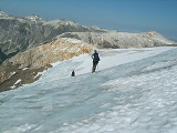
, a popular campsite due to the scenic views, abundant water for bathing and drinking, and a comfortable alpine meadow for camping. The trail the climbs up Mount Bassie
and crosses its western front and a small but crevasse
-ridden icefield. Especially in the late summer, when snow bridge
s have melted and blue ice
is prevalent, this portion of the route can be the most dangerous and difficult part of the trip. An orbicular ridge leads to the north after Mount Bassie and eventually curves east, splitting the Blue Lake
watershed on the western side of the island from the Baranof River
watershed on the eastern side of the island. The geology of the ridge (which also features basalt
dikes
) offers many flat locations to make camp with access to small pools for drinking water.
The ridge climbs to an unnamed peak and then descends to two separate roughly mile-long icefields that are locally known as the Indigo Glacier. These icefields are flat with a small rocky isthmus separating them (it is marked as one icefield on USGS
maps, however they have since receded into two). After the icefield the trail passes several alpine lakes and descends down to Baranof Lake
through a mix of temperate rainforest and cliffs. An informal trail leads from Baranof Lake
to the boardwalk of Baranof Warm Springs.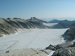
. It has increased opportunities for skiing in the winter. This route shares no common segments with the traditional route.
This route begins with the approach to Peak 5390
and continues down past Mount Furuhelm
and down to Warm Springs Bay. Once at Warm Springs Bay, a pick-up to shuttle is required to cross the bay to Baranof Warm Springs.
, including one near-death incident. The primary causes for complications on the trail are poor weather, poor decision-making after bad weather sets in, lack of equipment, and poor physical fitness.
Local guides are available informally. There are currently no commercial guides, although such a venture has been planned in the past (incidentally, the principal guide-to-be nearly perished while surveying the standard route).
s and crampons
are useful for traversing ice.
Baranof Island
Baranof Island, also sometimes called Baranov Island, Shee or Sitka Island, is an island in the northern Alexander Archipelago in the Alaska Panhandle, in Alaska. The name Baranof was given in 1805 by Imperial Russian Navy captain U. F. Lisianski to honor Alexander Andreyevich Baranov...
, Alaska
Alaska
Alaska is the largest state in the United States by area. It is situated in the northwest extremity of the North American continent, with Canada to the east, the Arctic Ocean to the north, and the Pacific Ocean to the west and south, with Russia further west across the Bering Strait...
from the community of Sitka
Sitka City and Borough, Alaska
The City and Borough of Sitka, originally called New Archangel under Russian Rule, is a unified city-borough located on Baranof Island and the southern half of Chichagof Island in the Alexander Archipelago of the Pacific Ocean , in the U.S...
to Baranof Warm Springs
Baranof Warm Springs, Alaska
Baranof Warm Springs is a small, primarily seasonally-occupied community in the U.S. state of Alaska, located on the eastern side of Baranof Island, from which it likely derives its name, in the Alexander Archipelago. It is occasionally referred to simply as Baranof...
. The trail is popular among resident Sitkans, but also attracts out-of-town backpacker
Backpacking (wilderness)
Backpacking combines the activities of hiking and camping for an overnight stay in backcountry wilderness...
s. From start to finish, the trail spans approximately 16 miles (25.7 km) long, but owing to the difficult terrain covered, the average crossing requires two to three days. Very-fit distance runners, however, can complete the trail in a day, the record being held by Sitka resident and ultra-endurance athlete Steve Reifenstuhl who has completed the trail in seven hours.
Route
The usual direction of passage is west to east, or Sitka to Baranof Warm Springs. Since Baranof Warm Springs has no permanent transportation options inbound or outbound, backpackers must either turn around and hike back to Sitka, or take a float plane or boat back if one is available. One can begin the trail either being dropped off at Medvejie Hatchery by boat or hiking from Herring Cove on the 3.5 miles (5.6 km) private road to Medvejie Hatchery. The trail begins in the Medvejie LakeMedvejie Lake
Medvejie Lake is a long, narrow, snow-fed lake on Baranof Island just south of Sitka, Alaska in the Alaskan Panhandle, which drains into Silver Bay, southeast of Sitka, on west coast of Baranof Island, Alexander Archipelago.- Etymology :...
valley and continues up to Camp Lake
Camp Lake (Alaska)
Camp Lake is a small snow-melt and rain-fed lake that feeds into the Blue Lake watershed on Baranof Island in the Alexander Archipelago in the Alaskan Panhandle. Camp Lake is a popular destination for the first night on the Baranof Cross-Island Trail due to its surrounding alpine meadow and the...
, a popular campsite due to the scenic views, abundant water for bathing and drinking, and a comfortable alpine meadow for camping. The trail the climbs up Mount Bassie
Mount Bassie
Mount Bassie is a large mountain in the center of Baranof Island, Alaska, United States, within the City and Borough of Sitka.Mount Bassie is a massive hulk of rock, its footprint covering nearly five square miles...
and crosses its western front and a small but crevasse
Crevasse
A crevasse is a deep crack in an ice sheet rhys glacier . Crevasses form as a result of the movement and resulting stress associated with the sheer stress generated when two semi-rigid pieces above a plastic substrate have different rates of movement...
-ridden icefield. Especially in the late summer, when snow bridge
Snow bridge
Snow bridge is an arc across a crevasse, a crack in rock, a creek, or some other opening in terrain. It is typically formed by snow drift, which first creates a cornice, which may gradually grow to reach the other side of the opening.-Dangers:...
s have melted and blue ice
Blue ice (glacial)
Blue ice occurs when snow falls on a glacier, is compressed, and becomes part of a glacier that winds its way toward a body of water . During its travels, air bubbles that are trapped in the ice are squeezed out, and the size of the ice crystals increases, making it clear...
is prevalent, this portion of the route can be the most dangerous and difficult part of the trip. An orbicular ridge leads to the north after Mount Bassie and eventually curves east, splitting the Blue Lake
Blue Lake
Blue Lake may refer to:Australia*Blue Lake *Blue Lake *Blue Lake National Park, Queensland, on North Stradbroke IslandCroatia*Blue Lake New Zealand...
watershed on the western side of the island from the Baranof River
Baranof River
Baranof River is a glacially-fed river on the eastern side of Baranof Island, in the Alexander Archipelago, in the Alaska Panhandle. The source of the river is from the unnamed icefields surrounding Peak 5390...
watershed on the eastern side of the island. The geology of the ridge (which also features basalt
Basalt
Basalt is a common extrusive volcanic rock. It is usually grey to black and fine-grained due to rapid cooling of lava at the surface of a planet. It may be porphyritic containing larger crystals in a fine matrix, or vesicular, or frothy scoria. Unweathered basalt is black or grey...
dikes
Dike (geology)
A dike or dyke in geology is a type of sheet intrusion referring to any geologic body that cuts discordantly across* planar wall rock structures, such as bedding or foliation...
) offers many flat locations to make camp with access to small pools for drinking water.
The ridge climbs to an unnamed peak and then descends to two separate roughly mile-long icefields that are locally known as the Indigo Glacier. These icefields are flat with a small rocky isthmus separating them (it is marked as one icefield on USGS
United States Geological Survey
The United States Geological Survey is a scientific agency of the United States government. The scientists of the USGS study the landscape of the United States, its natural resources, and the natural hazards that threaten it. The organization has four major science disciplines, concerning biology,...
maps, however they have since receded into two). After the icefield the trail passes several alpine lakes and descends down to Baranof Lake
Baranof Lake
Baranof Lake is a glacially-fed, horseshoe-shaped lake on the eastern side of Baranof Island, in Alaska. Baranof Lake borders the community of Baranof Warm Springs and also has a Forest Service cabin on the northwestern end of the lake...
through a mix of temperate rainforest and cliffs. An informal trail leads from Baranof Lake
Baranof Lake
Baranof Lake is a glacially-fed, horseshoe-shaped lake on the eastern side of Baranof Island, in Alaska. Baranof Lake borders the community of Baranof Warm Springs and also has a Forest Service cabin on the northwestern end of the lake...
to the boardwalk of Baranof Warm Springs.
Alternate route
An alternate route terminates on the southern side of Warm Springs BayWarm Springs Bay
Warm Springs Bay is a 2.4 mile-long bay located just outside of the small community of Baranof Warm Springs on Baranof Island in the Alexander Archipelago, Alaska. Warm Springs Bay receives the outflow of Baranof Lake and Baranof River. Warm Springs Bay is located at .It receives its name from...
. It has increased opportunities for skiing in the winter. This route shares no common segments with the traditional route.
This route begins with the approach to Peak 5390
Peak 5390
Peak 5390 is the highest peak on Baranof Island and the Alexander Archipelago which are located in southeast Alaska. Peak 5390 is an informal name, named after the peak's height in feet, but is unnamed by USGS maps. Peak 5390 ranks as the highest island-based peak in the U.S...
and continues down past Mount Furuhelm
Mount Furuhelm
Mount Furuhelm is a 3,620 foot peak located on Baranof Island just east and adjacent to Peak 5390 in Alaska. It is located at .Mount Furuhelm was named for Johan Hampus Furuhjelm , who was governor of Russian America from 1859 to 1863.Mount Furuhelm actually has both an east and west peak less...
and down to Warm Springs Bay. Once at Warm Springs Bay, a pick-up to shuttle is required to cross the bay to Baranof Warm Springs.
Safety
In the past ten years three separate parties have had to be rescued by the United States Coast GuardUnited States Coast Guard
The United States Coast Guard is a branch of the United States Armed Forces and one of the seven U.S. uniformed services. The Coast Guard is a maritime, military, multi-mission service unique among the military branches for having a maritime law enforcement mission and a federal regulatory agency...
, including one near-death incident. The primary causes for complications on the trail are poor weather, poor decision-making after bad weather sets in, lack of equipment, and poor physical fitness.
Local guides are available informally. There are currently no commercial guides, although such a venture has been planned in the past (incidentally, the principal guide-to-be nearly perished while surveying the standard route).
Equipment
Standard backpacking gear is required for a crossing, but also gear that accounts for alpine campsites exposed to high winds and severe weather elements. Ice axeIce axe
An ice axe, is a multi-purpose ice and snow tool used by mountaineers both in the ascent and descent of routes which involve frozen conditions. It can be held and employed in a number of different ways, depending on the terrain encountered...
s and crampons
Crampons
Crampons are traction devices used to improve mobility on snow and ice. There are three main attachment systems for footwear: step-in, hybrid, and strap bindings. The first two require boots with welts, the last adapt to any type....
are useful for traversing ice.
External links
- Anchorage Daily NewsAnchorage Daily NewsThe Anchorage Daily News is a daily newspaper based in Anchorage, Alaska, in the United States. It is often referred to colloquially as either "the Daily News" or "the ADN"...
overview of rescue