
Banyalbufar
Encyclopedia
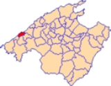
Banyalbufar is a municipality on the Spanish
Balearic
island of Majorca. The town of the same name is the administrative seat of the municipality. It borders the municipalities of Estellencs
, Puigpunyent, Esporles
, and Valldemossa
.
mountain off the C-710 along the road from Andratx
to Valldemossa
. The municipality also contains four smaller mountains, of which Mola de Planícia is the highest at 942 m, and Sa Talaia is the lowest at 309 m. Rainfall can occur all year round. The driest month is July with an average rainfall of 10.1 l/m². The heaviest rainfall is in October at 80.9 l/m². The heaviest rainfall in Banyalbufar occurred on 10 June 1975 at 170 l/m².
settlement established on the island in the 10th Century. The second component, Bahar, supposedly derives from the Catalan
la mar or sa mar (meaning "the sea"), or from the Latin
juxta mare (meaning "by the sea"). The original Moorish meaning of Banyalbufar is, therefore, "founded by the sea".
Following the Catalan conquest of Majorca in 1229, Banyalbufar came under control of Gilabert de Cruïlles and Ramon sa Clusa. During the Middle Ages
and up until the 15th Century, the valley was ruled under a practically absolutist government: the Barony of Banyalbufar. The baron maintained the civil and criminal jurisdiction over the entire population.
The inhabitants of Banyalbufar devoted themselves almost exclusively to agriculture. Fishing remained merely a secondary industry. Produce included wheat, barley, pulses, olives, flax, hemp, saffron and, above all, wine. The local Malvasier grape was highly prized. After a long period of decline, there are now efforts to revive this fruit. In previous times, the location was in reality a large vineyard. Around 2,000 steppes emanate from the peak of the location, which were once devoted exclusively to the production of Malvasier wine. The wine was highly favoured by the King of Aragon
, and was in no small part a motive for the conquest by James I
.
Today mostly tomatoes and other fruits are produced. Irrigation of the fields is inextricably linked to the production of wine. The solution presented to solve irrigatory problems in this region is impressive and prime example of the Moorish hydro-expertise on the island. The aqueducts, which provide vital cost-free water from the mountains for the agriculture, originate for the greater part from the Arabic period. The dry walls, constructed by the Moors from the stones in the fields, halt the flower of water, and the numerous water basins capture any excess water.
regions and only around 6% was foreigners. The highest population recorded was in 1920 at 894 inhabitants. The population dropped drastically in the next ten years, probably due to political unrest in the locality. In 1930, Banyalbufar had only 200 inhabitants.
In 1991 there were still illiterate people in Banyalbufar. The majority of the population receive either no formal education (111 persons), a basic education (99 persons) or a mid-stage education (86 persons), with only 47 persons undertaking the Bachillerato.
The population spread is a follows. Figures are accurate as of 1 January 2005 and do not include isolated communities (and thus do not comprise the total number of inhabitants of Algaida).
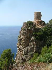 In the centre of the area lies an old manor-house known as La Baronía. The Cafe Bellavista lives up to its name; one can enjoy a beautiful view of the coast from the café. In order to protect themselves from Moorish pirates, the inhabitants constructed a watchtower outside of the municipality. The watchtower, known as the Torre de ses Animes, overlooks the sea and is today the most-visited point of interest in Majorca. The small bay-beach is accessible only by a steep stairway.
Spain
Spain , officially the Kingdom of Spain languages]] under the European Charter for Regional or Minority Languages. In each of these, Spain's official name is as follows:;;;;;;), is a country and member state of the European Union located in southwestern Europe on the Iberian Peninsula...
Balearic
Balearic Islands
The Balearic Islands are an archipelago of Spain in the western Mediterranean Sea, near the eastern coast of the Iberian Peninsula.The four largest islands are: Majorca, Minorca, Ibiza and Formentera. The archipelago forms an autonomous community and a province of Spain with Palma as the capital...
island of Majorca. The town of the same name is the administrative seat of the municipality. It borders the municipalities of Estellencs
Estellencs
Estellencs is a small municipality to the west of Majorca, one of the Balearic Islands, Spain.It lies between the Tramuntana mountain range, on the slopes of Mount Galatzo , and the Mediterranean sea.-External links:*...
, Puigpunyent, Esporles
Esporles
Esporles is a small municipality on Majorca, one of the Balearic Islands, Spain.Economy is mostly based on agriculture and animal husbandry....
, and Valldemossa
Valldemossa
Valldemossa or Valldemosa is a village and municipality on the island of Majorca, part of the Spanish autonomous community of the Balearic Islands....
.
Geography
The municipality of Banyalbufar has an area of 18.1 km² and lies next to the Serra de TramuntanaSerra de Tramuntana
The Serra de Tramuntana is a mountain range running southwest-northeast which forms the northern backbone of the Spanish island of Majorca. It is also the name given to the comarca of the same area...
mountain off the C-710 along the road from Andratx
Andratx
Andratx is a municipality on Majorca, one of the Balearic Islands, along the Mediterranean east coast of Spain. It is located on the southwest tip of the island.-History:...
to Valldemossa
Valldemossa
Valldemossa or Valldemosa is a village and municipality on the island of Majorca, part of the Spanish autonomous community of the Balearic Islands....
. The municipality also contains four smaller mountains, of which Mola de Planícia is the highest at 942 m, and Sa Talaia is the lowest at 309 m. Rainfall can occur all year round. The driest month is July with an average rainfall of 10.1 l/m². The heaviest rainfall is in October at 80.9 l/m². The heaviest rainfall in Banyalbufar occurred on 10 June 1975 at 170 l/m².
History
The original name Banyalbahar comprises two different components: banya and bahar. The first component, Banya, derives from the name of a MoorishMoors
The description Moors has referred to several historic and modern populations of the Maghreb region who are predominately of Berber and Arab descent. They came to conquer and rule the Iberian Peninsula for nearly 800 years. At that time they were Muslim, although earlier the people had followed...
settlement established on the island in the 10th Century. The second component, Bahar, supposedly derives from the Catalan
Catalan language
Catalan is a Romance language, the national and only official language of Andorra and a co-official language in the Spanish autonomous communities of Catalonia, the Balearic Islands and Valencian Community, where it is known as Valencian , as well as in the city of Alghero, on the Italian island...
la mar or sa mar (meaning "the sea"), or from the Latin
Latin
Latin is an Italic language originally spoken in Latium and Ancient Rome. It, along with most European languages, is a descendant of the ancient Proto-Indo-European language. Although it is considered a dead language, a number of scholars and members of the Christian clergy speak it fluently, and...
juxta mare (meaning "by the sea"). The original Moorish meaning of Banyalbufar is, therefore, "founded by the sea".
Following the Catalan conquest of Majorca in 1229, Banyalbufar came under control of Gilabert de Cruïlles and Ramon sa Clusa. During the Middle Ages
Middle Ages
The Middle Ages is a periodization of European history from the 5th century to the 15th century. The Middle Ages follows the fall of the Western Roman Empire in 476 and precedes the Early Modern Era. It is the middle period of a three-period division of Western history: Classic, Medieval and Modern...
and up until the 15th Century, the valley was ruled under a practically absolutist government: the Barony of Banyalbufar. The baron maintained the civil and criminal jurisdiction over the entire population.
The inhabitants of Banyalbufar devoted themselves almost exclusively to agriculture. Fishing remained merely a secondary industry. Produce included wheat, barley, pulses, olives, flax, hemp, saffron and, above all, wine. The local Malvasier grape was highly prized. After a long period of decline, there are now efforts to revive this fruit. In previous times, the location was in reality a large vineyard. Around 2,000 steppes emanate from the peak of the location, which were once devoted exclusively to the production of Malvasier wine. The wine was highly favoured by the King of Aragon
Aragon
Aragon is a modern autonomous community in Spain, coextensive with the medieval Kingdom of Aragon. Located in northeastern Spain, the Aragonese autonomous community comprises three provinces : Huesca, Zaragoza, and Teruel. Its capital is Zaragoza...
, and was in no small part a motive for the conquest by James I
James I of Aragon
James I the Conqueror was the King of Aragon, Count of Barcelona, and Lord of Montpellier from 1213 to 1276...
.
Today mostly tomatoes and other fruits are produced. Irrigation of the fields is inextricably linked to the production of wine. The solution presented to solve irrigatory problems in this region is impressive and prime example of the Moorish hydro-expertise on the island. The aqueducts, which provide vital cost-free water from the mountains for the agriculture, originate for the greater part from the Arabic period. The dry walls, constructed by the Moors from the stones in the fields, halt the flower of water, and the numerous water basins capture any excess water.
Demographics
Banyalbufar has 568 inhabitants (as of 2005) with a population density of 31 persons/km². In 1991, 85.7% of the inhabitants were Majorcan, 8.3% came from other SpanishSpain
Spain , officially the Kingdom of Spain languages]] under the European Charter for Regional or Minority Languages. In each of these, Spain's official name is as follows:;;;;;;), is a country and member state of the European Union located in southwestern Europe on the Iberian Peninsula...
regions and only around 6% was foreigners. The highest population recorded was in 1920 at 894 inhabitants. The population dropped drastically in the next ten years, probably due to political unrest in the locality. In 1930, Banyalbufar had only 200 inhabitants.
In 1991 there were still illiterate people in Banyalbufar. The majority of the population receive either no formal education (111 persons), a basic education (99 persons) or a mid-stage education (86 persons), with only 47 persons undertaking the Bachillerato.
The population spread is a follows. Figures are accurate as of 1 January 2005 and do not include isolated communities (and thus do not comprise the total number of inhabitants of Algaida).
- Banyalbufar (407 inhabitants)
- Es Port des Canonge (62 inhabitants)
- Son Coll (28 inhabitants)
Points of interest
Walking routes
One of the most beautiful walks around the island is the route to the Port des Canonge in Banyalbufar. Once a philosophers' path through the peaceful fishing bay, the route leads imperceptibly downhill through shaded pine forests. Further on, the route is bounded by bizarre rock formations and affords magnificent views of the coast. The far-flung bay of Port des Canonge, with its tiny gravel beaches comes alive only at weekends, when the local fisherman set their boats to the water. The endpoint of the walk is a curve in the road between km posts 85 and 86 east of Banyalbufar. The walk traverses an easy to moderately difficult, wide forest path to Port des Canonge. The path is marked at intervals with orange signs.Beaches
Playas y calas (beaches and swimming coves) within the community of Banyalbufar include Cala Banyalbufa, Es Corral Fals, Son Bunyola and Es Port des Canonge.Accommodation
There are 190 rooms across three hotels, Sa Baronia, Sa Coma and Mar i Vent, as well as the rural guesthouse, Ca'n Busquets.External links
- The Community of Banyalbufar — available in Catalan, Spanish, English and German.
- Informació de l'Institut Balear d'Estadística — data information from the Balearic Institute of Statistics.
- All Things Mallorca — General Information and Images on Banyalbufar.