

Back of the Wight
Encyclopedia
Back of the Wight is an area on the Isle of Wight
, England
that has a unique history and social background. Part of this stems from the fact that the area was and still is very cut off from the rest of the island and is made up of small villages strung out along the coast, such as Brighstone
, Shorwell
and Mottistone
.
18 miles long. The shore is edged by cliffs averaging around 300 feet high from Freshwater
to Compton, broken at two points, Grange Chine and Brook Chine, which provide the only easy, natural access to the sea through steep gorges. Stretching out from this coast are three ledges of resistant rock, the Brook, Brighstone and Atherfield
ledges, on which many ships have been wrecked over the years.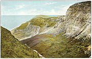 Past Compton and Brighstone, the coast is wild and there are only four access points inland, Whale, Walpen and Ladder Chine and the greatest of them all, Blackgang Chine
, which was once a home of smugglers. This shore is in constant threat of erosion.
The most obvious natural features on land are the downs that enclose the area and cut it off from the rest of the island; parts of these are protected as a Site of Special Scientific Interest
and large stretches owned by the National Trust
. Brighstone Forest
, which covers the top of Brighstone Down
, is the largest on the island.
At St. Catherine's Point the Back of the Wight changes into the Undercliff of Ventnor.
. The main settlements are:
in order to make use of the clean waters of the Buddle Brook
. During the 4th century the Empire broke up and the coast began to suffer from raids
by Vikings and Germanic tribes, which repeatedly laid waste to the area.
until the reign of King Arwald
, who died in battle when the kingdom of Wessex
invaded and converted the island at sword point by killing the inhabitants and re-settling it with Saxons. Saint Wilfred and the church were given large parts and converted the survivors. The island had been the last pagan part of England.
The Back of the Wight had a meagre and fragile economy at the time so this increased the hardships on the area by killing many of the population.
, Newtown
and Brading
. The people lived a harsh existence exposed to the elements and pirates. They scraped a livelihood from fishing, farming and salvage. Shipwrecks were a great help to these people and some say that the emphasis was on cargo not people. There has never been any proof of islanders wrecking
, but given how harsh their lives were it would not be surprising. In 1313 in a famous case the St Mary of Bayonne, from Gascony, ran ashore at Chale Bay
. The lord of Chale raised some men and demanded the 53 barrels of wine the ship was carrying. When King Edward II found out, he summoned them to Southampton and had them fined. The wine was destined for a monastery and the church cried sacrilege. As a result of this incident, the first lighthouse
on Wight was built at Chale, the St Catherine's Oratory
, where the lord's family paid for a light and prayers for his soul. This is the oldest medieval lighthouse in England. Its ruins are now known as the Pepperpot, and a half-built later lighthouse nearby is known as the Salt Shaker. From this period onwards the area lived in fear of French invasions.
between smugglers and Coastguard. In 1859 the first lifeboats were put in place at Brighstone and Brook
; they took part in many famous rescues and are commemorated in Brighstone Museum, which has many artefacts of the era.
When in 1892 the , a German liner, went aground on the Atherfield Ledge
, it took "virtually the whole of the sparse human population of the 'Back of the Wight' to get them to sea".
Also in the late 19th century, the area first became popular to visit and some noted figures established homes here, like Mottistone Manor
for the noted architects, the Seelys.
, HMS Pomone, HMS Assurance, .
, Vénus
, , the Sirenia and the Cedrine, whose timbers form part of Mottistone
church.
, Isle of Wight Pearl and the picture-postcard villages. The area hosts several events over the year including the Brighstone Christmas Tree Festival
, Brighstone Show and Chale Show.
The area is still poorly connected, particularly as erosion threatens the A3055 Military Road ("Millie" to locals), which runs along the coast connecting them. Compton bay and beach are popular with surfers due to waves that come across the Atlantic. Recent cuts have made the bus service more infrequent.
Isle of Wight
The Isle of Wight is a county and the largest island of England, located in the English Channel, on average about 2–4 miles off the south coast of the county of Hampshire, separated from the mainland by a strait called the Solent...
, England
England
England is a country that is part of the United Kingdom. It shares land borders with Scotland to the north and Wales to the west; the Irish Sea is to the north west, the Celtic Sea to the south west, with the North Sea to the east and the English Channel to the south separating it from continental...
that has a unique history and social background. Part of this stems from the fact that the area was and still is very cut off from the rest of the island and is made up of small villages strung out along the coast, such as Brighstone
Brighstone
Brighstone is a village and civil parish on the Isle of Wight, 6 miles southwest of Newport on the B3399 road. Brighstone was previously known as "Brixton"...
, Shorwell
Shorwell
Shorwell is a village and civil parish on the Isle of Wight, United Kingdom. It is located six kilometres from Newport in the southwest of the island. Shorwell was one of Queen Victoria's favourite places to visit on the Isle of Wight.-History:...
and Mottistone
Mottistone
Mottistone is a village on the Isle of Wight, it is located in the popular tourist area the Back of the Wight. It is located 8 Miles southwest of Newport in the southwest of the island. It is home to the National Trust's Mottistone Manor.-History:...
.
Geography
Roughly speaking the Back of the Wight is the land on the southern side of the downs in the West and the boundary following the curve of the downs till they meet the sea near St. Catherine's Point. The main part of the Back of the Wight is formed of a large bayBay
A bay is an area of water mostly surrounded by land. Bays generally have calmer waters than the surrounding sea, due to the surrounding land blocking some waves and often reducing winds. Bays also exist as an inlet in a lake or pond. A large bay may be called a gulf, a sea, a sound, or a bight...
18 miles long. The shore is edged by cliffs averaging around 300 feet high from Freshwater
Freshwater, Isle of Wight
Freshwater is a large village and civil parish at the western end of the Isle of Wight, England. Freshwater Bay is a small cove on the south coast of the Island which also gives its name to the nearby part of Freshwater....
to Compton, broken at two points, Grange Chine and Brook Chine, which provide the only easy, natural access to the sea through steep gorges. Stretching out from this coast are three ledges of resistant rock, the Brook, Brighstone and Atherfield
Atherfield Ledge
Atherfeild Ledge is a rocky outcrop extending from the coast of the Back of the Wight, Isle of Wight. This is a famous shipwreck location. Along with Brook Ledge and Brighstone Ledge it is one of the area's main shipping hazards.-Geography:...
ledges, on which many ships have been wrecked over the years.
Blackgang Chine
Blackgang Chine is the location of a now-destroyed chine in the soft Cretaceous cliffs about 6 miles from Ventnor at the southern tip of the Isle of Wight just below St Catherine's Down. Since 1843 it has been home to the Blackgang Chine amusement park, run by the Dabell family who also run the...
, which was once a home of smugglers. This shore is in constant threat of erosion.
The most obvious natural features on land are the downs that enclose the area and cut it off from the rest of the island; parts of these are protected as a Site of Special Scientific Interest
Site of Special Scientific Interest
A Site of Special Scientific Interest is a conservation designation denoting a protected area in the United Kingdom. SSSIs are the basic building block of site-based nature conservation legislation and most other legal nature/geological conservation designations in Great Britain are based upon...
and large stretches owned by the National Trust
National Trust for Places of Historic Interest or Natural Beauty
The National Trust for Places of Historic Interest or Natural Beauty, usually known as the National Trust, is a conservation organisation in England, Wales and Northern Ireland...
. Brighstone Forest
Brighstone Forest
Brighstone Forest is located in the southwest of the Isle of Wight. It is the largest forest on the Isle of Wight, being just a few hectares larger than Parkhurst Forest. It is spread over a number of hilly ridges which form the backbone of the Isle of Wight. From west to east the ridges are...
, which covers the top of Brighstone Down
Brighstone Down
Brighstone Down is a chalk down on the Isle of Wight. It is located close to the village of Brighstone, in the southwest of the island , and rises to 214 metres at its highest point, northeast of the village of Mottistone....
, is the largest on the island.
At St. Catherine's Point the Back of the Wight changes into the Undercliff of Ventnor.
Geology
The geology of the area is mainly chalk, a fact proved most dramatically by the cliffs near Freshwater and at Compton, where clay starts to occur as well, these formations are unique for the way the layers have been tilted exposing ancient, fossil bearing strata of the Vectis Formation overlaid with the Wessex Formation .Settlements
Most of the settlements in the area are villages or hamlets that have evolved around farms or water courses. Settlement in the area has never been great and the villages are mostly old in construction. Many exist because of medieval churches and manors such as Mottistone ManorMottistone Manor
Mottistone Manor is a National Trust property in the village of Mottistone on the Isle of Wight. It has popular gardens and is a listed building.It was first mentioned in documents related to the Domesday Book....
. The main settlements are:
- BrighstoneBrighstoneBrighstone is a village and civil parish on the Isle of Wight, 6 miles southwest of Newport on the B3399 road. Brighstone was previously known as "Brixton"...
, near the centre - BrookBrook, Isle of Wight-Background:It is situated on the south west coast of the Island between Brighstone and Freshwater, and borders a section of rugged coastline , the Back of the Wight, facing into the English Channel and towards the famous Needles and west Wight cliffs....
- ShorwellShorwellShorwell is a village and civil parish on the Isle of Wight, United Kingdom. It is located six kilometres from Newport in the southwest of the island. Shorwell was one of Queen Victoria's favourite places to visit on the Isle of Wight.-History:...
- MottistoneMottistoneMottistone is a village on the Isle of Wight, it is located in the popular tourist area the Back of the Wight. It is located 8 Miles southwest of Newport in the southwest of the island. It is home to the National Trust's Mottistone Manor.-History:...
- ChaleChaléChalé is a Brazilian municipality located in the state of Minas Gerais. The city belongs to the mesoregion of Zona da Mata and to the microregion of Manhuaçu.-See also:* List of municipalities in Minas Gerais-References:...
- FreshwaterFreshwater, Isle of WightFreshwater is a large village and civil parish at the western end of the Isle of Wight, England. Freshwater Bay is a small cove on the south coast of the Island which also gives its name to the nearby part of Freshwater....
, on the edge of the area
Pre-history
There is little evidence of the region having been settled in pre-history; apart from the Longstone at Mottistone there are few artifacts. That there were once dinosaurs is proved by the numerous types of bones and fossils that have been excavated from the cliffs, including some species unique to the island. At the time the fossils were laid down, between 125 and 110 million years ago, the island was at a latitude similar to that of North Africa.Romans
In AD 43 the Romans invaded the island, which they called Vectis. Although most of their presence was elsewhere, they did built a villa at Rock, BrighstoneBrighstone
Brighstone is a village and civil parish on the Isle of Wight, 6 miles southwest of Newport on the B3399 road. Brighstone was previously known as "Brixton"...
in order to make use of the clean waters of the Buddle Brook
Buddle Brook
Buddle Brook a small river on the Isle of Wight, England. The Brook drains water from the southern side of Brighstone Down and as far to the east as the village of Shorwell. Its flow is the greatest of the streams in the South-West of the Island...
. During the 4th century the Empire broke up and the coast began to suffer from raids
Raid (military)
Raid, also known as depredation, is a military tactic or operational warfare mission which has a specific purpose and is not normally intended to capture and hold terrain, but instead finish with the raiding force quickly retreating to a previous defended position prior to the enemy forces being...
by Vikings and Germanic tribes, which repeatedly laid waste to the area.
Saxons
In Saxon times the island was colonized by JutesJutes
The Jutes, Iuti, or Iutæ were a Germanic people who, according to Bede, were one of the three most powerful Germanic peoples of their time, the other two being the Saxons and the Angles...
until the reign of King Arwald
Arwald
Arwald was the last Jutish King of the Isle of Wight and last pagan king in Anglo-Saxon England until the Vikings in the 9th century. His name may have been "Arwald" or "Atwald" - Bede's script is often difficult to read...
, who died in battle when the kingdom of Wessex
Wessex
The Kingdom of Wessex or Kingdom of the West Saxons was an Anglo-Saxon kingdom of the West Saxons, in South West England, from the 6th century, until the emergence of a united English state in the 10th century, under the Wessex dynasty. It was to be an earldom after Canute the Great's conquest...
invaded and converted the island at sword point by killing the inhabitants and re-settling it with Saxons. Saint Wilfred and the church were given large parts and converted the survivors. The island had been the last pagan part of England.
The Back of the Wight had a meagre and fragile economy at the time so this increased the hardships on the area by killing many of the population.
Middle Ages
During medieval times the people of the Back of the Wight were very poor, particularly compared to the new prosperity of towns such as YarmouthYarmouth, Isle of Wight
Yarmouth is a port and civil parish in the western part of the Isle of Wight, off the southern coast of mainland England. The town is named for its location at the mouth of the small Western Yar river...
, Newtown
Newtown, Isle of Wight
Newtown is a small hamlet on the Isle of Wight, in England. In medieval times it was a thriving borough.Newtown is located on the large natural harbour on the Island's north-western coast, now mostly a National Nature Reserve owned and managed by the National Trust.The Caul Bourne stream running...
and Brading
Brading
The ancient 'Kynges Towne' of Brading is the main town of the civil parish of the same name. The ecclesiastical parish of Brading used to cover about a tenth of the Isle of Wight. The current civil parish now includes the town itself and Adgestone, Morton, Nunwell and other outlying areas between...
. The people lived a harsh existence exposed to the elements and pirates. They scraped a livelihood from fishing, farming and salvage. Shipwrecks were a great help to these people and some say that the emphasis was on cargo not people. There has never been any proof of islanders wrecking
Wrecking (shipwreck)
Wrecking is the practice of taking valuables from a shipwreck which has foundered near or close to shore. Often an unregulated activity of opportunity in coastal communities, wrecking has been subjected to increasing regulation and evolved into what is now known as marine salvage...
, but given how harsh their lives were it would not be surprising. In 1313 in a famous case the St Mary of Bayonne, from Gascony, ran ashore at Chale Bay
Chale Bay
Chale Bay is a bay on the south west coast of the Isle of Wight, England. It lies to the west of the village of Chale from which it takes its name. It faces south west towards the English Channel, its shoreline is 5km in length and is gently curving. It stretches from Artherfield Point in the north...
. The lord of Chale raised some men and demanded the 53 barrels of wine the ship was carrying. When King Edward II found out, he summoned them to Southampton and had them fined. The wine was destined for a monastery and the church cried sacrilege. As a result of this incident, the first lighthouse
Lighthouse
A lighthouse is a tower, building, or other type of structure designed to emit light from a system of lamps and lenses or, in older times, from a fire, and used as an aid to navigation for maritime pilots at sea or on inland waterways....
on Wight was built at Chale, the St Catherine's Oratory
St Catherine's Oratory
St. Catherine's Oratory is a medieval lighthouse on St. Catherine's Down near the southern coast of the Isle of Wight, the Back of the Wight. It was built by Lord of Chale Walter de Godeton as an act of penance for plundering wine from the wreck of St. Marie of Bayonne in Chale Bay on April 20,...
, where the lord's family paid for a light and prayers for his soul. This is the oldest medieval lighthouse in England. Its ruins are now known as the Pepperpot, and a half-built later lighthouse nearby is known as the Salt Shaker. From this period onwards the area lived in fear of French invasions.
18th century and beyond
In the 18th century there were a succession of stormy winters that increased the number of wrecks on the Back's coast. Salvage and theft were combined with thriving local smuggling. Many buildings in the area are formed of parts of these ships. The Coastguard were established on the Island at this time. They were hated because they fought the smuggling trade, although they were hardly saints; there is an interesting local tale about the commander of the Yarmouth station who "couldn't hear" the sounds of a raging gun battle going on at Alum BayAlum Bay
Alum Bay is a bay near the westernmost point of the Isle of Wight, England, within sight of the Needles. Of geological interest and a tourist attraction, the bay is noted for its multi-coloured sand cliffs.-Geology:...
between smugglers and Coastguard. In 1859 the first lifeboats were put in place at Brighstone and Brook
Brook, Isle of Wight
-Background:It is situated on the south west coast of the Island between Brighstone and Freshwater, and borders a section of rugged coastline , the Back of the Wight, facing into the English Channel and towards the famous Needles and west Wight cliffs....
; they took part in many famous rescues and are commemorated in Brighstone Museum, which has many artefacts of the era.
When in 1892 the , a German liner, went aground on the Atherfield Ledge
Atherfield Ledge
Atherfeild Ledge is a rocky outcrop extending from the coast of the Back of the Wight, Isle of Wight. This is a famous shipwreck location. Along with Brook Ledge and Brighstone Ledge it is one of the area's main shipping hazards.-Geography:...
, it took "virtually the whole of the sparse human population of the 'Back of the Wight' to get them to sea".
Also in the late 19th century, the area first became popular to visit and some noted figures established homes here, like Mottistone Manor
Mottistone Manor
Mottistone Manor is a National Trust property in the village of Mottistone on the Isle of Wight. It has popular gardens and is a listed building.It was first mentioned in documents related to the Domesday Book....
for the noted architects, the Seelys.
Noted shipwrecks
Several local books include detailed accounts of the lifeboat and coastguard rescues of the sailors of the many ships that have been wrecked on the area's dangerous coast. Some of the more high-profile vessels include:- Needles
, HMS Pomone, HMS Assurance, .
- The South West
, Vénus
French corvette Vénus (1794)
Vénus was a corvette of the French Navy that the British captured in 1800.French sources refer to her as a corvette of 28-guns, however in British service she was classified as a sloop...
, , the Sirenia and the Cedrine, whose timbers form part of Mottistone
Mottistone
Mottistone is a village on the Isle of Wight, it is located in the popular tourist area the Back of the Wight. It is located 8 Miles southwest of Newport in the southwest of the island. It is home to the National Trust's Mottistone Manor.-History:...
church.
Today
Today the region is popular with tourists with attractions such as Blackgang ChineBlackgang Chine
Blackgang Chine is the location of a now-destroyed chine in the soft Cretaceous cliffs about 6 miles from Ventnor at the southern tip of the Isle of Wight just below St Catherine's Down. Since 1843 it has been home to the Blackgang Chine amusement park, run by the Dabell family who also run the...
, Isle of Wight Pearl and the picture-postcard villages. The area hosts several events over the year including the Brighstone Christmas Tree Festival
Brighstone Christmas Tree Festival
Brighstone Christmas Tree Festival is a local event occurring in churches of the Brighstone parish on the Isle of Wight in England for the winter tourist season.This charitable event is used to raise money for maintenance of churches in the parish....
, Brighstone Show and Chale Show.
The area is still poorly connected, particularly as erosion threatens the A3055 Military Road ("Millie" to locals), which runs along the coast connecting them. Compton bay and beach are popular with surfers due to waves that come across the Atlantic. Recent cuts have made the bus service more infrequent.