

Babeldaob
Encyclopedia
Palau
Palau , officially the Republic of Palau , is an island nation in the Pacific Ocean, east of the Philippines and south of Tokyo. In 1978, after three decades as being part of the United Nations trusteeship, Palau chose independence instead of becoming part of the Federated States of Micronesia, a...
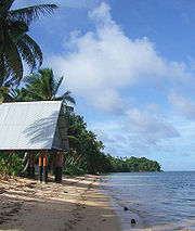
. Its area, 331 km² (128 mi²), makes up over 70% of the area of the entire country, and about 30% of the population, with about 6,000 people living there. Babeldoab is one of the most undeveloped populated islands in the Pacific.
Geography
Babeldaob is located northeast of KororKoror
Koror is the state comprising the main commercial centre of the Republic of Palau. It consists of several islands, the most prominent being Koror Island ....
and contains the site of the new national capital, Ngerulmud
Ngerulmud
Ngerulmud, a settlement in the State of Melekeok, is where the offices of the government of Palau are. The official capital is Melekeok. On 7 October 2006, government officials moved their offices in the former capital of Koror to Ngerulmud....
. Unlike most of the islands of Palau, Babeldaob is mountainous. It contains Palau's highest point, the 242 meter tall Mount Ngerchelchuus
Mount Ngerchelchuus
Mount Ngerchelchuus is the Republic of Palau's highest point, located at the border of the states of Ngardmau and Ngaremlengui, on the island of Babeldaob....
. Babeldaob's eastern coast has many sandy beaches, in particular north from Ngiwal to Ngaraard, and the island's western coast has a shoreline with many mangrove
Mangrove
Mangroves are various kinds of trees up to medium height and shrubs that grow in saline coastal sediment habitats in the tropics and subtropics – mainly between latitudes N and S...
shrubs and trees.
Palau's second-most populous state, Airai
Airai
Airai, located on the southern coast of Babeldaob island, is the second-most populous state of Palau. It contains the country's chief airport, Airai International Airport, and is connected by the Koror-Babeldaob Bridge to nearby Koror Island....
, makes up the southern end of the island. The Airai airport is the nation's principal airport. The Koror-Babeldaob Bridge
Koror-Babeldaob Bridge
The Koror-Babeldaob Bridge is a bridge in Palau that connects Koror and Babeldaob Islands. It is a reinforced concrete, portal frame, cable-stayed bridge with a total length of 413 m. It was built by the Kajima Corporation of Japan in 2002, to replace the former, collapsed bridge built by Socio...
links Airai to Koror.
Babeldaob encompasses 10 of the 16 states of Palau
States of Palau
Palau is divided into sixteen administrative regions, called states .-External links:**...
, which are:
- AimeliikAimeliikAimeliik is an administrative division of the island country of Palau. It is one of the Republic of Palau's 16 states. It has an area of 52 km² and a population of 270 . State capital is the village of Mongami....
- AiraiAiraiAirai, located on the southern coast of Babeldaob island, is the second-most populous state of Palau. It contains the country's chief airport, Airai International Airport, and is connected by the Koror-Babeldaob Bridge to nearby Koror Island....
- MelekeokMelekeokMelekeok is a town in the State of Melekeok . It is located on the east coast of Palau's largest island, Babeldaob...
- NgaraardNgaraardNgaraard is the eighth state of the Republic of Palau, and was originally named Kerradel. Ngaraard is located on the northern tip of Babeldaob directly adjacent to Ngarchelong state. There are five hamlets in Ngaraard, including Choll, Elab, Ngebuked, Ngkeklau and the state capital, Ulimang,...
- NgarchelongNgarchelongNgarchelong is the name of state of the country of Palau. Ngarchelong is at the northern most tip of the island of Babeldaob. Only the state of Kayangel is farther north. Ngarchelong is an important historical site and has undergone archeological excavation....
- NgardmauNgardmauNgardmau is one of Palau's sixteen states and is located on the west side of Babeldaob between the states of Ngaraard and Ngeremlengui. Its total area is . According to the last census, 221 persons live in Ngardmau. Their 46 households are situated in three hamlets: Ngetbong, Ngerutoi and Urdmau...
- NgatpangNgatpangNgatpang is one of Palau's sixteen states. It comprises an area of around 47 square kilometers in the west of Palau's largest island, Babeldaob, facing onto Ngeremeduu Bay. The state capital is Oikuul. It has a population of 464, making it Palau's 5th largest state in population.-External links:*...
- NgchesarNgchesarNgchesar is one of the sixteen states of the small pacific island nation of Palau. There are about 300 inhabitants, and its capital is Ngersuul...
- Ngeremlengui
- NgiwalNgiwalNgiwal is one of the sixteen states of Palau. It has a population of 223 and an area of 26 km². The administrative center is Ngerkeai....
History
Babeldaob was the location to which 426 members of the Sokehs tribe were banished by the German Empire following the Sokehs RebellionSokehs Rebellion
Sokehs Rebellion was an uprising of the Sokehs tribe against local German rule that started on Sokehs Island off the main island of Pohnpei in the Eastern Caroline Islands in 1910/1911...
on Sokehs Island and Pohnpei. Japan as mandatory power
League of Nations mandate
A League of Nations mandate was a legal status for certain territories transferred from the control of one country to another following World War I, or the legal instruments that contained the internationally agreed-upon terms for administering the territory on behalf of the League...
after World War I administered the return of the Sokehs in stages between 1917 and 1927.
During World War II
World War II
World War II, or the Second World War , was a global conflict lasting from 1939 to 1945, involving most of the world's nations—including all of the great powers—eventually forming two opposing military alliances: the Allies and the Axis...
the Japanese garrison
Garrison
Garrison is the collective term for a body of troops stationed in a particular location, originally to guard it, but now often simply using it as a home base....
was composed of 21,449 IJA
IJA
IJA can refer to:* Imperial Japanese Army* International Jugglers' Association* International Jousting Association* Instituto Justo Arosemena* The Internet Journal of Anesthesiology* International Judges Association* Empress Ija...
men under the command of Lieutenant-General Sadae Inoue and 8,286 IJN
IJN
The abbreviation IJN may refer to:* International Justice Network or IJNetwork, a Human Rights Organization* Imperial Japanese Navy, the navy of Japan from 1868 until it was dissolved in 1947* Institut Jean Nicod, a French interdisciplinary research center...
men under the command of Vice-Admiral Kenmi Itoh. Babeldaob was bypassed by the allied forces during the war.