
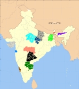
Aspirant states of India
Encyclopedia
Demands for the creation of new states have been a chronic feature of the India
India
India , officially the Republic of India , is a country in South Asia. It is the seventh-largest country by geographical area, the second-most populous country with over 1.2 billion people, and the most populous democracy in the world...
n polity since the inception of the republic. Such agitations typically base themselves on claims of neglect or discrimination meted out to them by the central or relevant state governments. Some such ongoing agitations are chronicled here.
Bodoland
The agitation for the creation of a separate BodolandBodoland
Bodoland is an area located in the north bank of Brahmaputra river in the state of Assam in north east region of India, by the foothills of Bhutan and Arunachal Pradesh; inhabited predominantly by the Bodo people. Currently the map of Bodoland includes the Bodoland Territorial Areas District ...
state resulted in an agreement between the Indian Government, the Assam
Assam
Assam , also, rarely, Assam Valley and formerly the Assam Province , is a northeastern state of India and is one of the most culturally and geographically distinct regions of the country...
state government and the Bodo Liberation Tigers Force
Bodo Liberation Tigers Force
Bodo Liberation Tigers Force , also called Bodo Liberation Tigers , was an armed group operating in the Bodo dominated regions of Assam which demanded a separate state for the Bodos to be carved out of Assam...
. Per that agreement of February 10, 2003, the Bodoland Territorial Council, an entity subordinate to the government of Assam, was created to govern four districts covering 3082 Bodo-majority villages in Assam.
The text of the agreement can be found here. Elections to the council were held on May 13, 2003, and Hagrama Mahillary was sworn in as chief of the 46-member council on June 4, 2003.
Delhi
Both DelhiDelhi
Delhi , officially National Capital Territory of Delhi , is the largest metropolis by area and the second-largest by population in India, next to Mumbai. It is the eighth largest metropolis in the world by population with 16,753,265 inhabitants in the Territory at the 2011 Census...
is an Union Territories
Union Territory
A Union Territory is a sub-national administrative division of India, in the federal framework of governance. Unlike the states of India, which have their own elected governments, union territories are ruled directly by the federal government; the President of India appoints an Administrator or...
with its own legislatures and chief ministers, but not yet full state. The previous National Democratic Alliance
National Democratic Alliance (India)
The National Democratic Alliance is a centre-right coalition of political parties in India. At the time of its formation in 1998, it was led by the Bharatiya Janata Party and had thirteen constituent parties. Its convenor is Sharad Yadav, and its honorary chairman is former prime minister Atal...
government introduced a bill in parliament to grant full statehood to Delhi, but the legislation has yet to be passed.
Gorkhaland
A violent struggle for a state of Gorkhaland by the Gorkha National Liberation FrontGorkha National Liberation Front
Gorkha National Liberation Front is a political party in the Darjeeling District of West Bengal, India...
in the 1980s resulted in the formation of the Darjeeling Gorkha Hill Council
Darjeeling Gorkha Hill Council
Darjeeling Gorkha Hill Council , also once known for a short period of time as Darjeeling Gorkha Autonomous Hill Council , is a semi-autonomous body that looks after the administration of the Darjeeling District in the state of West Bengal, India...
in 1988. However, the aspirations of the people of Darjeeling and the surrounding areas were not fulfilled and the demand for full statehood emerged once again in 2007 with the Gorkha Janmukti Morcha
Gorkha Janmukti Morcha
Gorkha Janmukti Morcha is a registered political party which campaigns for the creation of a separate state within India, out of districts in the north of West Bengal...
as its chief proponent. After the West Bengal state assembly election, 2011
West Bengal state assembly election, 2011
The West Bengal state assembly election, 2011 was held in six phases between 18 April and 10 May 2011 for all the 294 seats of the Vidhan Sabha in the state of West Bengal in India. The Trinamool Congress won an absolute majority of seats. Swami Ramdev backed Mamta and actively campaigned with his...
, the Gorkha Janmukti Morcha has signed an agreement with the state government to establish a Gorkhaland Territorial Administration
Gorkhaland Territorial Administration
Gorkhaland Territorial Administration is a semi-autonomous administrative body for the Darjeeling hills in West Bengal, India. The GTA will replace the Darjeeling Gorkha Hill Council, which was formed in 1988 and administered the Darjeeling hills for 23 years...
to replace the DGHC.
Harit Pradesh
There is a demand to carve out separate state of Harit PradeshHarit Pradesh
Harit Pradesh is a proposed new state of India comprising the western parts of Uttar Pradesh state. Braj Pradesh and Pashchim Pradesh are alternative names that have been proposed, because the region incorporates the historic region of Braj and is the western part of Uttar Pradesh...
out of Uttar Pradesh
Uttar Pradesh
Uttar Pradesh abbreviation U.P. , is a state located in the northern part of India. With a population of over 200 million people, it is India's most populous state, as well as the world's most populous sub-national entity...
. Harit Pradesh would comprise parts of Western Uttar Pradesh
Western Uttar Pradesh
Western Uttar Pradesh, sometimes simply referred to as West U.P., is a region in India that comprises the western districts of Uttar Pradesh state, including the areas of Rohilkhand and Braj. The region has some demographic, economic and cultural patterns which are distinct from other parts of...
. The proposed state would include 22 districts in Six divisions – Meerut, Saharanpur, Moradabad, Bareilly, Agra and Aligarh. Cultural and economical differences between Eastern and Western part of Uttar Pradesh are the main reason behind the demand of Harit Pradesh. At the village level, some commentators have observed that Western Uttar Pradesh
Western Uttar Pradesh
Western Uttar Pradesh, sometimes simply referred to as West U.P., is a region in India that comprises the western districts of Uttar Pradesh state, including the areas of Rohilkhand and Braj. The region has some demographic, economic and cultural patterns which are distinct from other parts of...
resembles Haryana and Rajasthan more than it does Eastern Uttar Pradesh.
The most prominent current-day advocate for the creation of the new state is Ajit Singh
Ajit Singh
Ajit Singh may refer to:* Dekh Bhai Dekh, music composer/singer* Chaudhary Ajit Singh, founder and chief of the political party Rashtriya Lok Dal in Uttar Pradesh, India...
, the leader of the Rashtriya Lok Dal
Rashtriya Lok Dal
Rashtriya Lok Dal is a political party in India. Ajit Singh is the party president. He is carrying on the political legacy of Charan Singh and the original Lok Dal..Ch. Charan Singh was a great farmer leader and was a former Prime Minister of India...
party. Mayawati
Mayawati
Mayawati is the Chief Minister of Uttar Pradesh, India. She heads the Bahujan Samaj Party, which represents the Bahujans or Dalits, the weakest strata of Indian society. This is her fourth term as Chief Minister of Uttar Pradesh...
also supported the formation of Harit Pradesh
Harit Pradesh
Harit Pradesh is a proposed new state of India comprising the western parts of Uttar Pradesh state. Braj Pradesh and Pashchim Pradesh are alternative names that have been proposed, because the region incorporates the historic region of Braj and is the western part of Uttar Pradesh...
in December, 2009.
Kosal
Kosal, also known as Dakhin Kosal,Kosala or Koshal, is the ancient name of present day’s Western Orissa and Chhattisgarh state, which is referenced many times in Indian epics like the Puranas, the Ramayana and the Mahabharata.Kosal was surrounded by Radha (comprising present day Mayurbhanj district in Orissa, and Midnapur and Hugli district of in West Bengal) on the east. River Brahmaniwas is its eastern border. On the west of Kosal, the Rashtrikas were ruling their kingdom. Maikhala range and River Sionath were the western borders of Kosal.River Godavari and Indravati were bordering Kosal on the south and separating it from the Andhra. In the north river Kanahar, the tributary of river Shon was separating Kosal from Magadh. In medieval period this western Orissa region was known as Hirakhand or Samalpur kingdom.The Chinese philosopher, Huen Tsang, has mentioned in his book that from Kalinga he went north- west for 1800 li to Kosal, a country which was more than 6000 li in circuit, and its capital was above 40 li in circuit. It is further been noted that the country was called “South Kosal“, apparently to distinguish from the Kosal in North.
The Kosal region in Orissa state lies between 19º 37’- 23º N latitude and 82º 28’- 85º 22’ E longitudes comprising the districts of Sundargad, Jharsuguda,Debgad, Samalpur, Bargad, Sonepur, Baud, Balangir, Nuapada, Kalahandi, Nabarangpur, Aathmallik sub-division of Angul district. and Kashipur block of Rayagad district. It is surrounded by Jharkhand state on the north, on the east by the dist of Kendujhar, Angul and Kandhamal; on the south by Rayagada, Koraput and on the west by Chhattisgarh state.
The total area of Kosal is 55,693.06 km2 (excluding the area of Athmallik sub-division of Angul district). It comprises 32.35% of the total area of Orissa state. The cultivable area in this part of state is 15,452 km2 and irrigated area is 2,199 km2.
Total population : 1,00, 30,999 (2001 census)
Rural population : 63.7% of the total population
Urban population : 36.3% of the population
Literacy : 55.50%
Male Female ratio : 1000:976
These districts occupy 32.35% of the total geographical area (excluding Athmallik as data is not available) and 24.55% of the total population of Orissa. British Commissioner Hunter Sahib had coined the term Western Orissa for the first time when it became part of newly formed Orissa division of East India Co in 1905 AD. This geographical area is also recognised by state government of Orissa as the area under Western Orissa development council (WODC).
Many of the common generalisations of history that are made about Orissa do not seem to be applied to this region. Its different historical background and geographical location has helped it to develop a distinct cultural identity, language, social behavior and practice of its own which makes it different from the rest of the state. The language spoken throughout this stretch is popularly known as “Samalpuri” or “Sambalpuri”, which is way apart from the state official language “Oriya” by means of vocabulary, grammar and pronunciation. People use Oriya as a medium of education in school where as for day to day life they use Samalpuri. It becomes very difficult for kids to learn and acquire a new language other than their mother tongue at an early stage. There is a consciousness growing among intellectual mass of Western Orissa to recognise this language in the 8th schedule of the Indian constitution as Kosli or Samalpuri.
Ex-Member of Parliament from Debgarh Mr SriBallbha Panigrahi and Ex-Member of Parliament from Sambalpurconstituency Sri Prasanna Acharya have raised their voice for this cause in two different instances in the Parliament (Lok Sabha).
The language is transforming rapidly from a speaking language to a full fledge one. So many poets, writers have already written many great epics in this language. This Kosli language has cross border presence and spoken widely in Saraipali, Basna, Sarangad, Raigad, Jaspore area of Chhattishgarh state and some part in Jharkhand state too. Within the Orissa state, it is spoken in some part of Keojhar, Nabarangpur districts, Niyamagiri area in Rayagada dist and also spoken by tribal of Daspalla region in Nayagarh dist other than the core Kosli belt such as Sundargad, Jharsuguda, Debgad, Samalpur, Bargad, Sonepur, Baudh, Balangir, Nuapada, Kalahandi and Athhamallik sub-division in Angul dist.
This region is famous for its world famous Sambalpuri handlooms and vibrant rhythmic folk music popularly known asSamalpuri geet or gana.
Mithila
The ongoing demand for Mithila state is more on the underdevelopment keeping the boundaries where Maithili is spoken as per the Linguistic Survey of India by GA Grierson in 1904-28 which included:the then districts of Muzaffarpur, Darbhanga, Bhagalpur, Monghyer, Purnea, Santhal Paragana which now after several bifurcations of districts consists of twenty four Maithili speaking districts currently in Bihar and six in Jharkhand (Mithila protagonists also claim East Champaran and West Champaran on epical reason when it was in Mithila and also on economic and agro-climatic reasons)."Grierson judged that Maithili and its dialects could fairly be characterized as the language of the entire population of Darbhanga and Bhagalpur districts and of a majority or a significant minority of the populations of Muzaffarpur, Monghyer, Purnea and Santhal Parganas.
The Mithila protagonists demand the above districts which presently are divided in many districts –
in Bihar states’ districts:-
Darbhanga is divided in – Darbhanga, Madhubani and Samastipur
Bhagalpur is divided in – Supaul, Saharasa, Madhepura, Bhagalpur, Banka
Muzaffarpur is divided in Muzaffarpur, Sheohar,Sitamarhi and Vaishali
Monghyer is divided in Monghyr,Begusarai, Khagaria, Lakhisarai, Sheikhpura and Jamui
Purnea is divided in Purnea, Araria, Kathihar and Kishanganj
- Jharkhand’s Santhal Parganas is divided in Godda, Devghar, Dumka, Jamtara, Sahibganj and Pakur.
People of all districts of the proposed Mithila state do speak Maithili
Maithili language
Maithili language is spoken in the eastern region of India and South-eastern region of Nepal. The native speakers of Maithili reside in Bihar, Jharkhand,parts of West Bengal and South-east Nepal...
. The fact is that parts of proposed Mithila, so-called Angika Language protagonists do claim Angika is spoken by the people, still Angika is not recognised as a separate language by the Sahitya Akademy,the apex body of literature in India and including George A. Grierson, the convention is to treat the speech as a dialect of Maithili. The other recognized language of proposed Mithila is Santhali in the south of Ganga. Maithili is only language of the region which has a vast treasure of literature, the earliest book is Varn ratnakar of 1224 AD.
During the 1950s at the time of the First State Reorganization Committee, Maithli was not put on the Indian Government schedule of recognized languages. Since then, there has been a strong push to see it reinstituted on the schedule. In 2003 the push was successful and Maithili was recognized on the VIII schedule of the Indian Constitution and once again given its proper status as a major Indian language.
In spite of the fact that only a part of the Mithila population were enumerated in the 2001 Indian Census, 12,179,122 Maithili speaking persons were identified making Maithli the thirteenth most popularly spoken language in India(vide website of the Census of India 2001). Of the 28 states of the Indian Union, 25 of them were established on the basis of language. Three of the newer states were established on the basis of economic backwardness and culture. A strong argument for a Mithila state can be made based on all three criteria; language, culture and economic need.
Purvanchal
PurvanchalPurvanchal
Purvanchal is a geographic region of north-central India, which comprises the eastern end of Uttar Pradesh state...
is a geographic region of north-central India
India
India , officially the Republic of India , is a country in South Asia. It is the seventh-largest country by geographical area, the second-most populous country with over 1.2 billion people, and the most populous democracy in the world...
, which comprises the eastern end of Uttar Pradesh
Uttar Pradesh
Uttar Pradesh abbreviation U.P. , is a state located in the northern part of India. With a population of over 200 million people, it is India's most populous state, as well as the world's most populous sub-national entity...
state. It is bounded by Nepal
Nepal
Nepal , officially the Federal Democratic Republic of Nepal, is a landlocked sovereign state located in South Asia. It is located in the Himalayas and bordered to the north by the People's Republic of China, and to the south, east, and west by the Republic of India...
to the north, Bihar
Bihar
Bihar is a state in eastern India. It is the 12th largest state in terms of geographical size at and 3rd largest by population. Almost 58% of Biharis are below the age of 25, which is the highest proportion in India....
state to the east, Bagelkhand
Bagelkhand
Bagelkhand or Baghelkhand, is a region in central India, in northeastern Madhya Pradesh state. It includes the Madhya Pradesh districts of Anuppur, Rewa, Satna, Shadol, Sidhi, and Umaria....
region of Madhya Pradesh
Madhya Pradesh
Madhya Pradesh , often called the Heart of India, is a state in central India. Its capital is Bhopal and Indore is the largest city....
state to the south, the Awadh
Awadh
Awadh , also known in various British historical texts as Oudh or Oude derived from Ayodhya, is a region in the centre of the modern Indian state of Uttar Pradesh, which was before independence known as the United Provinces of Agra and Oudh...
region of Uttar Pradesh to the west. Purvanchal comprises three divisions – Awadhi region in the west, Bhojpuri region in the east and the Baghelkhand region in the south.
The most commonly spoken language in Purvanchal is Bhojpuri
Bhojpuri language
Bhojpuri is a language spoken in parts of north-central and eastern India. It is spoken in the western part of state of Bihar, the northwestern part of Jharkhand, and the Purvanchal region of Uttar Pradesh , as well as adjoining parts of the Nepal Terai. Bhojpuri is also spoken in Guyana,...
.
Purvanchal area is represented by 23 Members of Parliament to the lower house of Indian Parliament, and 117 legislators in the 403 member Uttar Pradesh
Uttar Pradesh
Uttar Pradesh abbreviation U.P. , is a state located in the northern part of India. With a population of over 200 million people, it is India's most populous state, as well as the world's most populous sub-national entity...
state assebly or Vidhan Sabha
Vidhan Sabha
The Vidhan Sabha or the Legislative Assembly is the lower house or the sole house of the provincial legislature in the different states of India. The same name is also used for the lower house of the legislatures for two of the union territories, Delhi and Pondicherry...
.
Districts-Azamgarh
Azamgarh
Azamgarh is a town in the Indian state of Uttar Pradesh. It is headquarters of Azamgarh district and Azamgarh Division.-History:Azamgarh, one of the easternmost districts of the State, once formed a part of the ancient Kosala kingdom, except the north-eastern part of it which was included in the...
, Ballia
Ballia
Ballia is a city with a municipal board in the Indian state of Uttar Pradesh. The eastern boundary of the city lies at the junction of the Ganges and the Ghaghara...
, Chandoli, Deoria
Deoria
Deoria is a town in the state of Uttar Pradesh, India. It is one of 5 tehsils of Deoria district. The name of the Railway Station is Deoria Sadar.-Ancient:...
, Ghazipur
Ghazipur
Ghazipur , or Ghazipur City, previously spelt Ghazeepore, is a city/town and a municipal corporation and headquarter of Ghazipur district in the state of Uttar Pradesh, India. It is the administrative headquarters of Ghazipur Division and Sub-division...
, Gorakhpur
Gorakhpur
Gorakhpur is a city in the eastern part of the state of Uttar Pradesh in India, near the border with Nepal. It is the administrative headquarters of Gorakhpur District and Gorakhpur Division. Gorakhpur is one of the proposed capitals of the Purvanchal state which is yet to be formed...
, Jaunpur
Jaunpur
Jaunpur may refer to:* Jaunpur, Uttar Pradesh* Jaunpur district* Jaunpur Sultanate...
, Kushinagar
Kushinagar
Kushinagar , Kusinagar or Kusinara is a town and a nagar panchayat in Kushinagar district in the Indian state of Uttar Pradesh. It is an important Buddhist pilgrimage site, where Gautama Buddha is believed to have attained Parinirvana after his death.-Demographics: India census, Kushinagar had a...
, Maharajganj
Maharajganj
Maharajganj is a town and a notified area in Siwan district in the Indian state of Bihar.-Geography:Maharajganj is located at . It has an average elevation of 66 metres .-Demographics:...
, Mau
Mau
Mau , formerly Mau Nath Bhanjan , nearly 90 km from Varanasi is the powerhouse of textile weavers in Eastern UP, India. It is a small industrial town on the banks of Ghaghra . The Tamasa river flows through the city...
, Mirzapur
Mirzapur
Mirzapur is a city in the heart of North India, nearly 650 km between Delhi and Kolkata and also equidistant from Allahabad and Varanasi. Located in the state of Uttar Pradesh, Mirzapur has a population of a little over 205,264 and is renowned for its famous carpet and brassware industry...
, Sant Kabir Nagar, Sant Ravidas Nagar
Sant Ravidas Nagar
Sant Ravidas Nagar District -History:Sant Ravidas Nagar District was created on June 30, 1994 as 65th district of the state. The district is famous for its carpets in India and abroad.-Geography:...
, Siddharth Nagar
Siddharth Nagar
Siddharth Nagar may refer to:*Siddharthnagar district - India*Siddharth Nagar, Nepal...
, Varanasi
Varanasi
-Etymology:The name Varanasi has its origin possibly from the names of the two rivers Varuna and Assi, for the old city lies in the north shores of the Ganga bounded by its two tributaries, the Varuna and the Asi, with the Ganges being to its south...
.
As a fallout of Telangana
Telangana
Telangana is a region in the present state of Andhra Pradesh, India and formerly was part of Hyderabad state which was ruled by Nizam. It is bordered with the states of Maharashtra on the north and north-west, Karnataka on the west, Chattisgarh on the north-east and Orissa to the east...
creation movement, Mayawati
Mayawati
Mayawati is the Chief Minister of Uttar Pradesh, India. She heads the Bahujan Samaj Party, which represents the Bahujans or Dalits, the weakest strata of Indian society. This is her fourth term as Chief Minister of Uttar Pradesh...
proposed Dec 13th, 2009 to carve Purvanchal
Purvanchal
Purvanchal is a geographic region of north-central India, which comprises the eastern end of Uttar Pradesh state...
. out of Uttar Pradesh
Uttar Pradesh
Uttar Pradesh abbreviation U.P. , is a state located in the northern part of India. With a population of over 200 million people, it is India's most populous state, as well as the world's most populous sub-national entity...
.
Current movement for Purvanchal is spearheaded by famous politician Amar Singh
Amar Singh
Amar Singh may refer to:* Amar Singh , Indian test cricketer* Amar Singh , Indian politician* Amar Singh, son of Maharana Pratap...
.
Telangana
Telangana comprises the northern, non-coastal districts of Andhra PradeshAndhra Pradesh
Andhra Pradesh , is one of the 28 states of India, situated on the southeastern coast of India. It is India's fourth largest state by area and fifth largest by population. Its capital and largest city by population is Hyderabad.The total GDP of Andhra Pradesh is $100 billion and is ranked third...
, and includes the state capital, Hyderabad. The separate Telangana state movement started in 1950s when people unhappy with the merger with Andhra State expressed their discontent. In 1969, there was a full blown revolution by the students of Hyderabad that was controlled and 369 students were killed in police shootings. The demand has since been growing in people's hearts and became the tide-turner in all general elections from the year 2000. The Telangana Rashtra Samithi
Telangana Rashtra Samithi
Telangana Rashtra Samithi is a regional separatist political party in the southern Indian state of Andhra Pradesh.-Ideology:Telangana Rashtra Samithi's main aim is to separate Telangana region from Andhra Pradesh and to regain regional autonomy as it existed before the formation of Andhra Pradesh...
(TRS) is a political party formed on the single-point-agenda of formation of Telangana State. TRS in 2004, contested parliamentary elections in alliance with the Congress
Indian National Congress
The Indian National Congress is one of the two major political parties in India, the other being the Bharatiya Janata Party. It is the largest and one of the oldest democratic political parties in the world. The party's modern liberal platform is largely considered center-left in the Indian...
party and won 5 of 16 seats in the region. This rendered it a member of the coalition ruling India, and a carefully worded sentence about considering the demand for the creation of a new state "at an appropriate time" was duly included in the Common Minimum Programme
Common minimum programme
The Common Minimum Programme is a document outlining the minimum objectives of a coalition government in India. The document has acquired prominence since coalition governments have become the norm in India.-References:...
.
TRS chief K Chandrashekhar Rao sat for a fast-unto-death on 30th Nov, 2009 demanding formation of the state. On 9th Dec 2009, Home Minister P. Chidambaram announced an "resolution" for a Telangana state formation. But it has later put on hold due to pressures and causes from politicians and people from seemandhra ( costal and Rayalaseema) to prosper as united.
Tulu NaduTulu NaduTulu Nadu is a Tulu-speaking region spread over to parts of present Karnataka and Kerala States of India. It consists of the Dakshina Kannada and Udupi districts of Karnataka and the northern parts of the Kasaragod district of Kerala up to the Payaswini River...
The demand for creation of a separate state of Tulu NaduTulu Nadu
Tulu Nadu is a Tulu-speaking region spread over to parts of present Karnataka and Kerala States of India. It consists of the Dakshina Kannada and Udupi districts of Karnataka and the northern parts of the Kasaragod district of Kerala up to the Payaswini River...
, a prosperous region between Karnataka
Karnataka
Karnataka , the land of the Kannadigas, is a state in South West India. It was created on 1 November 1956, with the passing of the States Reorganisation Act and this day is annually celebrated as Karnataka Rajyotsava...
and Kerala
Kerala
or Keralam is an Indian state located on the Malabar coast of south-west India. It was created on 1 November 1956 by the States Reorganisation Act by combining various Malayalam speaking regions....
, is based on having a different language (Tulu
Tulu language
The Tulu language |?]]]) is a Dravidian language spoken by 1.95 million native speakers mainly in the southwest part of Indian state Karnataka known as Tulu Nadu. In India, 1.72 million people speak it as their mother tongue , increased by 10 percent over the 1991 census...
). Tuluvas are culturally distinct from the rest of Karnataka. Both the Karnataka and Kerala state governments have created Tulu Sahitya Academy- for the preservation and promotion of Tuluva culture, to quell separatis demands and to counter the accusation of cultural neglect.
Vidarbha
Vidarbha comprises the Amravati and Nagpur divisions in eastern Maharashtra. After British conquests from Mughals and Marathas in central India, Nagpur Province of British India was formed in 1853 with Nagpur as the capital. In 1861, "Central Province" was formed, with Nagpur as capital. In 1935, the Government of India Act, passed by British parliament, formed provincial assembly. Indian National Congress won a majority of seats and Narayan Bhaskar Khare became the first chief minister of Central Provinces in August 1937. In 1946 elections, Ravi Shankar Shukla became chief minister of Central Provinces and Berar, with Nagpur as capital. In the 1950 constitution of India, the state was renamed Madhya Pradesh. In 1953, the States Reorganisation Commission was formed by the Central Government of India, with Fazal Ali, Kavalam Madhava Panikkar, and Hridyanath Kunzru as members.The State Reorganization Act of 1956 was passed by the central government and Vidarbha became a part of Bombay state. Shortly after this, a plan to create a "Vidarbha state" with Nagpur as the capital was recommended by the state reorganization commission. Under pressure from the leaders of western Maharashtra, Maharashtra state was formed on 1 May 1960, thus continuing Vidarbha's dominance by the Maharashtra.
Support for a separate state of Vidarbha had been expressed by Loknayak Bapuji Aney and Pt Brijlal Biyani Vidarbha. The demand for the creation of a separate Vidarbha state is based in large part on these historical facts.
Allegations of neglect by the Maharashtra state government also are part of the issue. Jambuwantrao Dhote led a popular struggle for Vidarbha statehood in the 1970s. Two politicians, N.K.P. Salve and Vasant Sathe, have led 21st century attempts to bring about a state of Vidarbha.[10]
The demand has never enjoyed popularity as it was always raised by leaders of the Congress Party and Bharatiya Janata Party (BJP) from Vidharbha.
This situation has begun to change with a young leader from Nagpur, Nitin Gadkari becoming the president of the BJP, which is a staunch supporter of a separate Vidarbha state.
The other complex point is the inclusion of old Berar Province or the Amravati division comprising the districts of Amravati, Buldhana, Akola, Washim and Yavatmal districts. People in this western part of Vidharbha or the old Berar province are culturally, socially and politically more similar to Khandesh and Marathwada regions in Maharashtra. They were also part of the former Nizam's Hyderabad province, before being added to the former Central Provinces and Berar province.
[edit] Vindhya Pradesh
Vindhya Pradesh
Vindhya PradeshVindhya Pradesh
Vindhya Pradesh is a former state of India. It occupied an area of 23,603 sq. miles. It was created in 1948, shortly after Indian independence, from the territories of the princely states in the eastern portion of the former Central India Agency. It was named for the Vindhya Range, which runs...
is a region in Madhya Pradesh
Madhya Pradesh
Madhya Pradesh , often called the Heart of India, is a state in central India. Its capital is Bhopal and Indore is the largest city....
& former indian state of India
India
India , officially the Republic of India , is a country in South Asia. It is the seventh-largest country by geographical area, the second-most populous country with over 1.2 billion people, and the most populous democracy in the world...
. Area 23,185 sq. miles. It was created in 1948, shortly after Indian independence, from the territories of the princely state
Princely state
A Princely State was a nominally sovereign entitity of British rule in India that was not directly governed by the British, but rather by an Indian ruler under a form of indirect rule such as suzerainty or paramountcy.-British relationship with the Princely States:India under the British Raj ...
s in the eastern portion of the prev Central India Agency
Central India Agency
The Central India Agency was a political office of the British Indian Empire, which covered the northern half of present-day Madhya Pradesh state. The Central India Agency was made up entirely of princely states, which were under native rulers...
named after the Vindhya Range
Vindhya Range
The Vindhya Range is a range of older rounded mountains and hills in the west-central Indian subcontinent, which geographically separates the Indian subcontinent into northern India and Southern India.- Introduction :...
, located here. The capital of the Vindhya Pradesh was Rewa
Rewa, India
Rewa is formerly the capital of the princely state of Rewa and former state of Vindhya Pradesh in central India. It is an important city in the North Eastern part of Madhya Pradesh state of India bordering Allahabad, Mirzapur and Banda Districts of Uttar Pradesh and Satna and Sidhi Districts of...
. It lays between Uttar Pradesh
Uttar Pradesh
Uttar Pradesh abbreviation U.P. , is a state located in the northern part of India. With a population of over 200 million people, it is India's most populous state, as well as the world's most populous sub-national entity...
to the north and Chattisgarh to the south, and in the west surrounded by the state of Madhya Bharat
Madhya Bharat
Madhya Bharat , also known as Malwa Union was an Indian state in west-central India, created on 28 May 1948 from twenty-five princely states which until 1947 had been part of the Central India Agency, with Jivaji Rao Scindia as its Rajpramukh...
.
Recent Activities
In 2000, Sriniwas Tiwari, ex-speaker of the Madhya Pradesh assembly, advocated that nine districts be separated from Madhya Pradesh to re-create a new state of Vindhya Pradesh. Various organizations like Vindhaya Ekata Parishad, and Vidhya Punrodaya Samiti are actively working for the separate "Vindhya Pradesh".Hyderabad
There is a case for making Hyderabad a separate state. There is considerable disagreement between the aspirant TelanganaTelangana
Telangana is a region in the present state of Andhra Pradesh, India and formerly was part of Hyderabad state which was ruled by Nizam. It is bordered with the states of Maharashtra on the north and north-west, Karnataka on the west, Chattisgarh on the north-east and Orissa to the east...
state and the rest of Andhra Pradesh
Andhra Pradesh
Andhra Pradesh , is one of the 28 states of India, situated on the southeastern coast of India. It is India's fourth largest state by area and fifth largest by population. Its capital and largest city by population is Hyderabad.The total GDP of Andhra Pradesh is $100 billion and is ranked third...
about Hyderabrad. Both want it to be a part of their state, One proposed solution is to make it a separate state separate from both of them.
Others
- Andaman & Nicobar Islands
- Anga Pradesh Angika speaking state in Bihar. Angika has more than 30 Million speakers in India. Angika has its own traditional script- Anga LipiAnga Lipi-Etymology & History:Anga referred to a region in what is now Bihar, Jharkhand, West Bengal states of India, and Lipi meant script.Anga Script is mentioned in an ancient Sanskrit language Buddhist book "Lalitvistar" , which says Anga Lipi was one of the most important scripts among 64 other scripts...
. - AwadhAwadhAwadh , also known in various British historical texts as Oudh or Oude derived from Ayodhya, is a region in the centre of the modern Indian state of Uttar Pradesh, which was before independence known as the United Provinces of Agra and Oudh...
state consisting of Awadhi speaking districts of central Uttar PradeshUttar PradeshUttar Pradesh abbreviation U.P. , is a state located in the northern part of India. With a population of over 200 million people, it is India's most populous state, as well as the world's most populous sub-national entity...
. The population of proposed state would be approximately 5crores (50 million people) with an area of approximately 75,000 km2 and capital at LucknowLucknowLucknow is the capital city of Uttar Pradesh in India. Lucknow is the administrative headquarters of Lucknow District and Lucknow Division....
.http://www.livehindustan.com/news/talangana/bahas/239-241-86626.htmlhttp://www.prabhatkhabar.com/news/20871.aspx - Bhojpuri speaking state comprising Eastern Uttar PradeshUttar PradeshUttar Pradesh abbreviation U.P. , is a state located in the northern part of India. With a population of over 200 million people, it is India's most populous state, as well as the world's most populous sub-national entity...
and parts of BiharBiharBihar is a state in eastern India. It is the 12th largest state in terms of geographical size at and 3rd largest by population. Almost 58% of Biharis are below the age of 25, which is the highest proportion in India....
. Bhojpuri is a major language in India with over 150 million speakers and has a flourishing entertainment industry. - Braj PradeshBrajBraj is a region mainly in Uttar Pradesh of India, around Mathura-Vrindavan. Braj, though never a clearly defined political region in India but is very well demarcated culturally, is considered to be the land of Krishna and is derived from the Sanskrit word vraja...
consisting of Agra divisionAgra DivisionAgra Division is an administrative unit of Indian state of Uttar Pradesh. Agra Division consists of:-*Agra District*Firozabad District*Mainpuri District*Mathura District...
and Aligarh divisionAligarh DivisionAligarh division is an administrative unit of Indian state of Uttar Pradesh. Aligarh division consists of:-*Aligarh District*Etah District*Mahamayanagar District*Kanshiram Nagar District-See also:Districts of Uttar Pradesh...
from Uttar PradeshUttar PradeshUttar Pradesh abbreviation U.P. , is a state located in the northern part of India. With a population of over 200 million people, it is India's most populous state, as well as the world's most populous sub-national entity...
and districts of BharatpurBharatpur districtBharatpur District is a district of Rajasthan state in western India. The town of Bharatpur is the district headquarters.-History:When Bharatpur was a princely state, it was the only political entity ever to have a Chartreuse colored flag.-Demographics:...
and Gwalior from RajasthanRajasthanRājasthān the land of Rajasthanis, , is the largest state of the Republic of India by area. It is located in the northwest of India. It encompasses most of the area of the large, inhospitable Great Indian Desert , which has an edge paralleling the Sutlej-Indus river valley along its border with...
and Madhya PradeshMadhya PradeshMadhya Pradesh , often called the Heart of India, is a state in central India. Its capital is Bhopal and Indore is the largest city....
. The proposed capital would be in AgraAgraAgra a.k.a. Akbarabad is a city on the banks of the river Yamuna in the northern state of Uttar Pradesh, India, west of state capital, Lucknow and south from national capital New Delhi. With a population of 1,686,976 , it is one of the most populous cities in Uttar Pradesh and the 19th most...
.http://economictimes.indiatimes.com/features/the-sunday-et/dateline-india/Demand-for-separate-Braj-Pradesh-gains-momentum/articleshow/5382856.cms So far, BrajBrajBraj is a region mainly in Uttar Pradesh of India, around Mathura-Vrindavan. Braj, though never a clearly defined political region in India but is very well demarcated culturally, is considered to be the land of Krishna and is derived from the Sanskrit word vraja...
has remained as a historical and cultural region, rather than a political entity. Language of Braj is Braj Bhasha. - GondwanaGondwana (India)Gondwana is a region of India. Named after the Gondi people who live there , the name of the ancient continent of Gondwanaland was derived from Gondwana, because some of the earliest rock formations of this continent were first investigated in part of the region, in modern Orissa.As Gonds are...
, which would include portions of Andhra PradeshAndhra PradeshAndhra Pradesh , is one of the 28 states of India, situated on the southeastern coast of India. It is India's fourth largest state by area and fifth largest by population. Its capital and largest city by population is Hyderabad.The total GDP of Andhra Pradesh is $100 billion and is ranked third...
, ChhattisgarhChhattisgarhChhattisgarh is a state in Central India, formed when the 16 Chhattisgarhi-speaking South-Eastern districts of Madhya Pradesh gained separate statehood on 1 November 2000....
, Madhya PradeshMadhya PradeshMadhya Pradesh , often called the Heart of India, is a state in central India. Its capital is Bhopal and Indore is the largest city....
, and MaharashtraMaharashtraMaharashtra is a state located in India. It is the second most populous after Uttar Pradesh and third largest state by area in India...
. - KamtapurKamtapurKamtapur is the name of a state proposed in north West Bengal and Assam by the Rajbongshi people. The proposed state comprises some districts of West Bengal and other contiguous districts of Assam. This statehood demand is mostly led by Kamtapur People's Party....
in northern parts of West BengalWest BengalWest Bengal is a state in the eastern region of India and is the nation's fourth-most populous. It is also the seventh-most populous sub-national entity in the world, with over 91 million inhabitants. A major agricultural producer, West Bengal is the sixth-largest contributor to India's GDP...
. The proposed state consists of the districts of Koch BeharCooch Behar DistrictCooch Behar district is a district of the state of West Bengal, India, as well as the district's namesake town. During the British Raj, the town of Cooch Behar was the seat of a princely state of Koch Bihar, ruled by the Koch dynasty....
, JalpaiguriJalpaiguriJalpaiguri is a city in the state of West Bengal, India. It is the headquarters of Jalpaiguri district, and the divisional headquarters of the North Bengal region.-History:...
, and southern plains of Darjeeling including SiliguriSiliguriSiliguri is a city in the Indian state of West Bengal. It is located in the Siliguri Corridor or Chicken's Neck - a very narrow strip of land linking mainland India to its north-eastern states. It is also the transit point for air, road and rail traffic to the neighbouring countries of Nepal,...
city. - KaraikalKaraikalKaraikal is a major port city of east coast of India and a municipality in Karaikal district in the Union Territory of Pondicherry, India. Several explanations are offered for the word 'Karaikal'. The imperial Gazetteer gives it the meaning 'fish pass'. According to Julien vinson the town is said...
, which include KaraikalKaraikalKaraikal is a major port city of east coast of India and a municipality in Karaikal district in the Union Territory of Pondicherry, India. Several explanations are offered for the word 'Karaikal'. The imperial Gazetteer gives it the meaning 'fish pass'. According to Julien vinson the town is said...
district of Pondicherry, demanding UT Statehood for Karaikal which is physically lying 150 km south of Puducherry. - MithilaMithilaMithila was a city in Ancient India, the capital of the Videha Kingdom. The name Mithila is also commonly used to refer to the Videha Kingdom itself, as well as to the modern-day territories that fall within the ancient boundaries of Videha...
or Mithilanchal a MaithiliMaithili languageMaithili language is spoken in the eastern region of India and South-eastern region of Nepal. The native speakers of Maithili reside in Bihar, Jharkhand,parts of West Bengal and South-east Nepal...
speaking state. Mailthili is an Indo-Aryan language with 45 million speakers. It has its own traditional script. Mathili speaking persons in Mithila are becoming in minority; due to under-numeration,Mathili is on the second position in no of speaking persons in Mithila. Interestingly, due to over-numeration HindiHindiStandard Hindi, or more precisely Modern Standard Hindi, also known as Manak Hindi , High Hindi, Nagari Hindi, and Literary Hindi, is a standardized and sanskritized register of the Hindustani language derived from the Khariboli dialect of Delhi...
is the first and Santhali is the third most speaking language in proposed Mithila as per census of 2001. - Saurashtra, Gujarat: No demands for statehood since quite a time. Situation peaceful as it remains an integral part of Gujarat
- SeemaAndhra. Coastal region of Andhra Pradesh & Rayalseema region. B.N.Srikrishna report's option 2, 4 & 5.