Armorican Massif
Encyclopedia
Massif
In geology, a massif is a section of a planet's crust that is demarcated by faults or flexures. In the movement of the crust, a massif tends to retain its internal structure while being displaced as a whole...
that covers a large area in the northwest of France
France
The French Republic , The French Republic , The French Republic , (commonly known as France , is a unitary semi-presidential republic in Western Europe with several overseas territories and islands located on other continents and in the Indian, Pacific, and Atlantic oceans. Metropolitan France...
, including Brittany
Brittany
Brittany is a cultural and administrative region in the north-west of France. Previously a kingdom and then a duchy, Brittany was united to the Kingdom of France in 1532 as a province. Brittany has also been referred to as Less, Lesser or Little Britain...
, the western part of Normandy
Normandy
Normandy is a geographical region corresponding to the former Duchy of Normandy. It is in France.The continental territory covers 30,627 km² and forms the preponderant part of Normandy and roughly 5% of the territory of France. It is divided for administrative purposes into two régions:...
and the Pays de la Loire
Pays de la Loire
Pays de la Loire is one of the 27 regions of France. It is one of the regions created in the late 20th century to serve as a zone of influence for its capital, Nantes, one of a handful so-called "balancing metropolises" ¹...
. Its name comes from the old Armorica
Armorica
Armorica or Aremorica is the name given in ancient times to the part of Gaul that includes the Brittany peninsula and the territory between the Seine and Loire rivers, extending inland to an indeterminate point and down the Atlantic coast...
, a Gaul
Gauls
The Gauls were a Celtic people living in Gaul, the region roughly corresponding to what is now France, Belgium, Switzerland and Northern Italy, from the Iron Age through the Roman period. They mostly spoke the Continental Celtic language called Gaulish....
area between the Loire and the Seine
Seine
The Seine is a -long river and an important commercial waterway within the Paris Basin in the north of France. It rises at Saint-Seine near Dijon in northeastern France in the Langres plateau, flowing through Paris and into the English Channel at Le Havre . It is navigable by ocean-going vessels...
rivers. The massif is composed of metamorphic
Metamorphic rock
Metamorphic rock is the transformation of an existing rock type, the protolith, in a process called metamorphism, which means "change in form". The protolith is subjected to heat and pressure causing profound physical and/or chemical change...
and magmatic rocks that were metamorphosed
Metamorphism
Metamorphism is the solid-state recrystallization of pre-existing rocks due to changes in physical and chemical conditions, primarily heat, pressure, and the introduction of chemically active fluids. Mineralogical, chemical and crystallographic changes can occur during this process...
and/or deformed during the Hercynian or Variscan orogeny
Variscan orogeny
The Variscan orogeny is a geologic mountain-building event caused by Late Paleozoic continental collision between Euramerica and Gondwana to form the supercontinent of Pangaea.-Naming:...
(400 to 280 million years ago) and the earlier Cadomian orogeny
Cadomian Orogeny
The Cadomian Orogeny was a tectonic event or series of events in the late Neoproterozoic, about 650-550 Ma, which probably included the formation of mountains. This occurred on the margin of the Gondwana continent, involving one or more collisions of island arcs and accretion of other material at a...
(650 to 550 million years ago). The region was uplifted
Tectonic uplift
Tectonic uplift is a geological process most often caused by plate tectonics which increases elevation. The opposite of uplift is subsidence, which results in a decrease in elevation. Uplift may be orogenic or isostatic.-Orogenic uplift:...
when the Bay of Biscay
Bay of Biscay
The Bay of Biscay is a gulf of the northeast Atlantic Ocean located south of the Celtic Sea. It lies along the western coast of France from Brest south to the Spanish border, and the northern coast of Spain west to Cape Ortegal, and is named in English after the province of Biscay, in the Spanish...
opened during the Cretaceous
Cretaceous
The Cretaceous , derived from the Latin "creta" , usually abbreviated K for its German translation Kreide , is a geologic period and system from circa to million years ago. In the geologic timescale, the Cretaceous follows the Jurassic period and is followed by the Paleogene period of the...
period. The Cantabrian Mountains
Cantabrian Mountains
The Cantabrian Mountains or Cantabrian Range are one of the main systems of mountain ranges in Spain.They extend for more than approximately 180 miles across northern Spain, from the western limit of the Pyrenees to the edges of the Galician Massif close to Galicia, along the coast of the...
and the Armorican Massif were then rift shoulders of the Bay of Biscay.
The competent
Competence (geology)
In geology competence refers to the degree of resistance of rocks to either erosion or deformation in terms of relative mechanical strength. In mining 'competent rocks' are those in which an unsupported opening can be made. Competent rocks are more commonly exposed at outcrop as they tend to form...
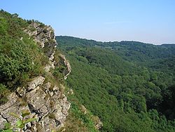
old rocks of the Armorican Massif have been eroded to a plateau
Plateau
In geology and earth science, a plateau , also called a high plain or tableland, is an area of highland, usually consisting of relatively flat terrain. A highly eroded plateau is called a dissected plateau...
like peneplain
Peneplain
A peneplain is a low-relief plain representing the final stage of fluvial erosion during times of extended tectonic stability. The existence of peneplains, and peneplanation as a geomorphological process, is not without controversy, due to a lack of contemporary examples and uncertainty in...
. The highest summit, the Mont des Avaloirs (Mayenne
Mayenne
Mayenne is a department in northwest France named after the Mayenne River.-History:Mayenne is one of the original 83 departments created during the French Revolution on March 4, 1790. The northern two thirds correspond to the western part of the former province of Maine...
département), is just 417 meters above sea level. The western part of the Armorican Massif (which covers Brittany) are the Monts d'Arrée
Monts d'Arrée
The Monts d'Arrée are an ancient mountain range in western Brittany which forms part of the Armorican massif. Historically it marked the border of the regions of Cornouaille and Léon....
.
Geology
During the NeoproterozoicNeoproterozoic
The Neoproterozoic Era is the unit of geologic time from 1,000 to 542.0 ± 1.0 million years ago. The terminal Era of the formal Proterozoic Eon , it is further subdivided into the Tonian, Cryogenian, and Ediacaran Periods...
, older parts of the Armorican Massif formed the northern margin of the paleocontinent Gondwana
Gondwana
In paleogeography, Gondwana , originally Gondwanaland, was the southernmost of two supercontinents that later became parts of the Pangaea supercontinent. It existed from approximately 510 to 180 million years ago . Gondwana is believed to have sutured between ca. 570 and 510 Mya,...
. During the Paleozoic
Paleozoic
The Paleozoic era is the earliest of three geologic eras of the Phanerozoic eon, spanning from roughly...
era
Era
An era is a commonly used word for long period of time. When used in science, for example geology, eras denote clearly defined periods of time of arbitrary but well defined length, such as for example the Mesozoic era from 252 Ma–66 Ma, delimited by a start event and an end event. When used in...
, the Armorican Massif was part of the microcontinent Armorica
Armorican terrane
The Armorican terrane, Armorican terrane assemblage, or simply Armorica, refers to a microcontinent or group of continental fragments that rifted away from Gondwana towards the end of the Silurian and collided with Laurussia towards the end of the Carboniferous during the Variscan orogeny...
, which probably also included terrane
Terrane
A terrane in geology is short-hand term for a tectonostratigraphic terrane, which is a fragment of crustal material formed on, or broken off from, one tectonic plate and accreted or "sutured" to crust lying on another plate...
s found in the Vosges
Vosges
Vosges is a French department, named after the local mountain range. It contains the hometown of Joan of Arc, Domrémy.-History:The Vosges department is one of the original 83 departments of France, created on February 9, 1790 during the French Revolution. It was made of territories that had been...
, Black Forest
Black Forest
The Black Forest is a wooded mountain range in Baden-Württemberg, southwestern Germany. It is bordered by the Rhine valley to the west and south. The highest peak is the Feldberg with an elevation of 1,493 metres ....
and Bohemian Massif
Bohemian Massif
The Bohemian Massif; or Český masiv; is in the geology of Central Europe a large massif stretching over central Czech republic, eastern Germany, southern Poland and northern Austria...
further east. Armorica rifted off the northern margin of Gondwana somewhere during the Ordovician
Ordovician
The Ordovician is a geologic period and system, the second of six of the Paleozoic Era, and covers the time between 488.3±1.7 to 443.7±1.5 million years ago . It follows the Cambrian Period and is followed by the Silurian Period...
or Silurian
Silurian
The Silurian is a geologic period and system that extends from the end of the Ordovician Period, about 443.7 ± 1.5 Mya , to the beginning of the Devonian Period, about 416.0 ± 2.8 Mya . As with other geologic periods, the rock beds that define the period's start and end are well identified, but the...
periods to move northward and collide with Laurussia during the Hercynian orogeny.
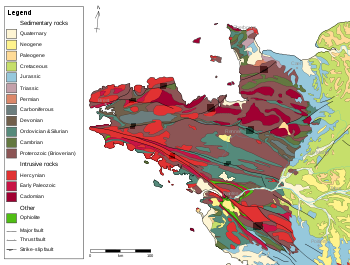
The oldest rocks of the massif are Neoproterozoic sediments of the Brioverian Supergroup which were deformed and metamorphosed during the Cadomian orogeny. These are overlain by lower Paleozoic (Cambrian
Cambrian
The Cambrian is the first geological period of the Paleozoic Era, lasting from Mya ; it is succeeded by the Ordovician. Its subdivisions, and indeed its base, are somewhat in flux. The period was established by Adam Sedgwick, who named it after Cambria, the Latin name for Wales, where Britain's...
to Devonian
Devonian
The Devonian is a geologic period and system of the Paleozoic Era spanning from the end of the Silurian Period, about 416.0 ± 2.8 Mya , to the beginning of the Carboniferous Period, about 359.2 ± 2.5 Mya...
) (meta-)sediments. The whole sequence was deformed, metamorphosed and intruded
Intrusion
An intrusion is liquid rock that forms under Earth's surface. Magma from under the surface is slowly pushed up from deep within the earth into any cracks or spaces it can find, sometimes pushing existing country rock out of the way, a process that can take millions of years. As the rock slowly...
by felsic
Felsic
The word "felsic" is a term used in geology to refer to silicate minerals, magma, and rocks which are enriched in the lighter elements such as silicon, oxygen, aluminium, sodium, and potassium....
magmas during the Hercynian orogeny.
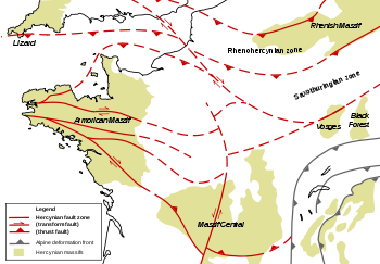
The massif is cut in three by two major late Hercynian southeast-northwest striking shear zone
Shear zone
A shear zone is a very important structural discontinuity surface in the Earth's crust and upper mantle. It forms as a response to inhomogeneous deformation partitioning strain into planar or curviplanar high-strain zones. Intervening blocks stay relatively unaffected by the deformation...
s (the North and South Armorican Shear Zones). The divisions are simply called the North, Center and South Armorican Zones. Generally the north was less deformed during the Hercynian orogeny than the south. The South Armorican Zone is considered part of the core of the Hercynian orogeny, comparable to the Moldanubian Zone
Moldanubian Zone
The Moldanubian Zone is in the regional geology of Europe a tectonic zone formed during the Variscan or Hercynian Orogeny...
of southern Germany
Germany
Germany , officially the Federal Republic of Germany , is a federal parliamentary republic in Europe. The country consists of 16 states while the capital and largest city is Berlin. Germany covers an area of 357,021 km2 and has a largely temperate seasonal climate...
and central Europe. Late Hercynian granitoid
Granitoid
A granitoid or granitic rock is a variety of coarse grained plutonic rock similar to granite which mineralogically are composed predominately of feldspar and quartz. Examples of granitoid rocks include granite, quartz monzonite, quartz diorite, syenite, granodiorite and trondhjemite. Many are...
bodies were intruded along the South Armorican Shear Zone. The northern parts of the Armorican Massif have less intrusive rocks, although a small zone in the northwest of Brittany (Léon Zone) forms an exception.