

Argyle, Manitoba
Encyclopedia
Argyle is a small hamlet located in the Canadian province of Manitoba
. Argyle is in Manitoba's Interlake Region, adjacent to the Rural Municipality of Rockwood
and approximately 30 km from Manitoba's capital, Winnipeg
. Nearby are the towns of Stonewall
, Balmoral, Teulon
, Grosse Isle
, Gunton
, Rosser
, Stony Mountain
and Selkirk
.(Note: This is the hamlet Argyle( not the Rural Municipality of Argyle which is located in Southern Manitoba, near Brandon.)
The major industry is agriculture,where mixed farming prevails. Many residents work in Winnipeg or surrounding towns. http://www.argylecountrylife.ca
of Canada, dividing Eastern
and Western Canada
also marked the division between the Argyle and Brant Districts, as well as the mark between neighboring Rockwood and Woodlands
Municipalities. As the local residents were living on either side of the Prime Meridian, several institutions derive their name by combining the words: Brant-Argyle.
Just North of the town, is the ancient Lake Agassiz beach ridge. About 10,000 years ago, this huge inland lake, the remnants of glaciers, began to drain in present day Manitoba. Left behind were the gravel and sand deposits that were once the beaches of the former lake. These ridges mark the northern edge of the Red River Valley, and offer a different geological atmosphere. Many local gravel pits are found in this region.
The Town is located approx 30 min north of Winnipeg off of highway 67 from Stonewall. Many farms and gravel companies thrive around this area. There is heavy forest and abundant wildlife everywhere.
. This land grant
was to encourage European farmers to fill up the vast prairies and secure the region between Ontario
and the Pacific Ocean
for Canada
.
The first settlers came from Argyllshire, Scotland
and named the district as Argyle in honor of their former home. The adjacent district was soon called Brant.
In 1878 the residents gathered in the Guthrie home to attend Presbyterian church services. In 1881 they built a small church on the East side of the Prime Meridian, called Brant-Argyle Presbyterian Church. The surrounding land was made into a cemetery. The earliest settlers buried their dead here.
Note:The church has since been converted into a home, with a porch.
It was also in 1878 that Thomas Guthrie established the first post office in the Argyle District. At first, Guthrie had to walk to Stonewall and later in 1882 he picked up the mail as it arrived in Marquette by rail. It is said that he received $50.00 annually for postmaster and an extra $12.00 per month for carrying the mail.
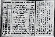
branched off the Oak Point Subdivision at Grosse Isle heading north. This first year, the railway reached a gravel pit, possibly to supply future or existing railbeds. The next year, this new local line reached through the Argyle and Brant Districts, ending at Woodroyd, Manitoba. Eventually, the line was built to Hodgson
, following a zig-zag formation to pass nearest the existing settlements.
When the railway came to the Argyle District, there was a church, post office, homes and farms. As they were spread across the country side, the nearest railstop was called Argyle Station. This was to distiquish the railway depot from the nearby post office.
With the arrival of the Canadian Northern Railway, a small store, blacksmith shop, station, elevator, stock yards, section master's house and the new post office were built. In the next few years, more homes were built and the new Brant Consolidated School (now Brant-Argyle School) was constructed (1914). This united the two small schools of the area. The railway made it easier to ship materials to and from the district.
It was truly the arrival of the Canadian Northern Railway that guaranteed the long term existence of Argyle.
The railway now serves as a recreational trail for hikers, bikers, and snowmobilers all across the Manitoba prairies.
In 2003, the Brant-Argyle School became a Provincial Historic Site. This is recognition that it is one of the last consolidated schools in the Province, and the best example of its style. see http://www.argylecountrylife.ca, and www.isd21.mb.ca.
There are many businesses that flourish in the community. Some of the oldest are the Argyle General Store, Meridian Trail General Store(Post Office), Argyle Memorial Community Hall, and the Argyle Curling Rink. All these facilities are used extensively by the community and surrounding area: see http://www.argylecountrylife.ca .
http://www.pioneerquest.caPioneer Quest: A Year in the Real West
(2000) was entirely filmed in the Argyle region. Two couples, the Logies and Treadways were the stars of this reality television series that aired on History Television. The homestead is located north east of the village and still offers tours of the 19th century pioneer settlement.
Manitoba
Manitoba is a Canadian prairie province with an area of . The province has over 110,000 lakes and has a largely continental climate because of its flat topography. Agriculture, mostly concentrated in the fertile southern and western parts of the province, is vital to the province's economy; other...
. Argyle is in Manitoba's Interlake Region, adjacent to the Rural Municipality of Rockwood
Rockwood, Manitoba
Rockwood is a rural municipality lying north of Winnipeg, Manitoba, Canada. It is part of the Winnipeg Capital Region and had a 2001 census population of 7,654. The towns of Stonewall and Teulon are both wholly located in Rockwood.-References:**...
and approximately 30 km from Manitoba's capital, Winnipeg
Winnipeg
Winnipeg is the capital and largest city of Manitoba, Canada, and is the primary municipality of the Winnipeg Capital Region, with more than half of Manitoba's population. It is located near the longitudinal centre of North America, at the confluence of the Red and Assiniboine Rivers .The name...
. Nearby are the towns of Stonewall
Stonewall, Manitoba
Stonewall is a town in the Canadian province of Manitoba with a population of 4,376 as of the 2006 census. The town is situated approximately north of Winnipeg on PTH 67. It is known for its limestone quarries. The local festival is the Quarry Days which is usually held over three days in August...
, Balmoral, Teulon
Teulon, Manitoba
Teulon is a community located approximately 60 kilometers north of Winnipeg, Manitoba, Canada, on Provincial Truck Highway 7. Located between Stonewall and Gimli, Teulon is commonly referred to as "The Gateway to the Interlake" and "The Petunia Capital of Manitoba"...
, Grosse Isle
Grosse Isle, Manitoba
Grosse Isle is a small rural community located 20 minutes north of Winnipeg, Manitoba. It is located in the Rural Municipality of Rockwood....
, Gunton
Gunton, Manitoba
Gunton is a small hamlet of about 50 people located 40 kilometers north of Winnipeg, Manitoba in the RM of Rockwood . It has no major industry as most residents work in Winnipeg or surrounding towns. Claims to fame include a bull test station and a long-abandoned quarry, recently seen in the 1997...
, Rosser
Rosser, Manitoba
Rosser, Manitoba is a rural municipality lying adjacent to the northwest side of Winnipeg at . It is part of the Winnipeg Capital Region. Its population as of the 2001 census was 1,412....
, Stony Mountain
Stony Mountain, Manitoba
Stony Mountain is a small community in Manitoba, Canada located approximately north of Winnipeg on Provincial Highway 7. The town is located in the Rural Municipality of Rockwood and is the location of Stony Mountain Ski Area...
and Selkirk
Selkirk, Manitoba
Selkirk is a city in the western Canadian province of Manitoba, located about 22 km northeast of the provincial capital Winnipeg on the Red River, near . As of the 2006 census, Selkirk had a population of 9,515....
.(Note: This is the hamlet Argyle( not the Rural Municipality of Argyle which is located in Southern Manitoba, near Brandon.)
The major industry is agriculture,where mixed farming prevails. Many residents work in Winnipeg or surrounding towns. http://www.argylecountrylife.ca
Geographical location
The Principal MeridianPrincipal meridian
A meridian is an imaginary line on the Earth's surface from the North Pole to the South Pole that connects all locations with a given longitude. Each is half of a great circle on the Earth's surface...
of Canada, dividing Eastern
Eastern Canada
Eastern Canada is generally considered to be the region of Canada east of Manitoba, consisting of the following provinces:* New Brunswick* Newfoundland and Labrador* Nova Scotia* Ontario* Prince Edward Island* Quebec...
and Western Canada
Western Canada
Western Canada, also referred to as the Western provinces and commonly as the West, is a region of Canada that includes the four provinces west of the province of Ontario.- Provinces :...
also marked the division between the Argyle and Brant Districts, as well as the mark between neighboring Rockwood and Woodlands
Woodlands, Manitoba
-External links:*...
Municipalities. As the local residents were living on either side of the Prime Meridian, several institutions derive their name by combining the words: Brant-Argyle.
Just North of the town, is the ancient Lake Agassiz beach ridge. About 10,000 years ago, this huge inland lake, the remnants of glaciers, began to drain in present day Manitoba. Left behind were the gravel and sand deposits that were once the beaches of the former lake. These ridges mark the northern edge of the Red River Valley, and offer a different geological atmosphere. Many local gravel pits are found in this region.
The Town is located approx 30 min north of Winnipeg off of highway 67 from Stonewall. Many farms and gravel companies thrive around this area. There is heavy forest and abundant wildlife everywhere.
Early settlers
Settled by European pioneers during the late 1870s, the newcomers were mostly those granted 160 acre (0.6474976 km²) of free land from the Canadian GovernmentGovernment of Canada
The Government of Canada, formally Her Majesty's Government, is the system whereby the federation of Canada is administered by a common authority; in Canadian English, the term can mean either the collective set of institutions or specifically the Queen-in-Council...
. This land grant
Land grant
A land grant is a gift of real estate – land or its privileges – made by a government or other authority as a reward for services to an individual, especially in return for military service...
was to encourage European farmers to fill up the vast prairies and secure the region between Ontario
Ontario
Ontario is a province of Canada, located in east-central Canada. It is Canada's most populous province and second largest in total area. It is home to the nation's most populous city, Toronto, and the nation's capital, Ottawa....
and the Pacific Ocean
Pacific Ocean
The Pacific Ocean is the largest of the Earth's oceanic divisions. It extends from the Arctic in the north to the Southern Ocean in the south, bounded by Asia and Australia in the west, and the Americas in the east.At 165.2 million square kilometres in area, this largest division of the World...
for Canada
Canada
Canada is a North American country consisting of ten provinces and three territories. Located in the northern part of the continent, it extends from the Atlantic Ocean in the east to the Pacific Ocean in the west, and northward into the Arctic Ocean...
.
The first settlers came from Argyllshire, Scotland
Argyll
Argyll , archaically Argyle , is a region of western Scotland corresponding with most of the part of ancient Dál Riata that was located on the island of Great Britain, and in a historical context can be used to mean the entire western coast between the Mull of Kintyre and Cape Wrath...
and named the district as Argyle in honor of their former home. The adjacent district was soon called Brant.
In 1878 the residents gathered in the Guthrie home to attend Presbyterian church services. In 1881 they built a small church on the East side of the Prime Meridian, called Brant-Argyle Presbyterian Church. The surrounding land was made into a cemetery. The earliest settlers buried their dead here.
Note:The church has since been converted into a home, with a porch.
It was also in 1878 that Thomas Guthrie established the first post office in the Argyle District. At first, Guthrie had to walk to Stonewall and later in 1882 he picked up the mail as it arrived in Marquette by rail. It is said that he received $50.00 annually for postmaster and an extra $12.00 per month for carrying the mail.
Brant Argyle School
In 1882 the local one-room schools were built for the settler's children. Brant, McLeod and Argyle schools were the original educational facilities that would eventually combine, making the Brant Consolidated School in 1914. It is Brant Argyle school is a 4 room brick school that is the only one of its kind in Manitoba that is still used as it was intended to - as a school for the local community children. The school is part of a Heratige agreement certificate which keeps it from being demolished or abbandonned. It will most likely become a museum one day. The school currently has about 60 students. It has a capacity of 100, and this multi grade environment hosts grades Kindergarten to grade 8. http://www.historicplaces.ca/visit-visite/com-ful_e.aspx?id=3486; http://www.isd21.mb.ca/argyle/; http://www.argylecountrylife.ca/school.html.Impact of the railway
In 1912, a small spur line built by the Canadian Northern RailwayCanadian Northern Railway
The Canadian Northern Railway is a historic Canadian transcontinental railway. At its demise in 1923, when it was merged into the Canadian National Railway , the CNoR owned a main line between Quebec City and Vancouver via Ottawa, Winnipeg, and Edmonton.-Manitoba beginnings:CNoR had its start in...
branched off the Oak Point Subdivision at Grosse Isle heading north. This first year, the railway reached a gravel pit, possibly to supply future or existing railbeds. The next year, this new local line reached through the Argyle and Brant Districts, ending at Woodroyd, Manitoba. Eventually, the line was built to Hodgson
Hodgson, Manitoba
Hodgson is a community in the Rural Municipality of Fisher in the Canadian province of Manitoba. It is located on Highway 325 in the north Interlake region of the province.-References:...
, following a zig-zag formation to pass nearest the existing settlements.
When the railway came to the Argyle District, there was a church, post office, homes and farms. As they were spread across the country side, the nearest railstop was called Argyle Station. This was to distiquish the railway depot from the nearby post office.
With the arrival of the Canadian Northern Railway, a small store, blacksmith shop, station, elevator, stock yards, section master's house and the new post office were built. In the next few years, more homes were built and the new Brant Consolidated School (now Brant-Argyle School) was constructed (1914). This united the two small schools of the area. The railway made it easier to ship materials to and from the district.
It was truly the arrival of the Canadian Northern Railway that guaranteed the long term existence of Argyle.
The railway now serves as a recreational trail for hikers, bikers, and snowmobilers all across the Manitoba prairies.
Present day Argyle
With the new millennium, Argyle celebrated the Homecoming 2000. This was a three day event in August that encompassed a parade, displays, social, breakfast and fellowship.In 2003, the Brant-Argyle School became a Provincial Historic Site. This is recognition that it is one of the last consolidated schools in the Province, and the best example of its style. see http://www.argylecountrylife.ca, and www.isd21.mb.ca.
There are many businesses that flourish in the community. Some of the oldest are the Argyle General Store, Meridian Trail General Store(Post Office), Argyle Memorial Community Hall, and the Argyle Curling Rink. All these facilities are used extensively by the community and surrounding area: see http://www.argylecountrylife.ca .
Films and television shows
The unique small town setting that Argyle has to offer has been captured in film. http://www.imdb.com/title/tt0790676/The Good Life (2007)starring Bill Paxton and Chris Klein was partially shot here. The Argyle General Store was the bus stop set.http://www.pioneerquest.caPioneer Quest: A Year in the Real West
Pioneer Quest: A Year in the Real West
Pioneer Quest: A Year in the Real West was Canadian documentary television series which aired on History Television and the Public Broadcasting Service in 2001. It is the first entry of producer Jamie Brown's "Quest series" which includes Quest for the Bay , Klondike: The Quest for Gold and Quest...
(2000) was entirely filmed in the Argyle region. Two couples, the Logies and Treadways were the stars of this reality television series that aired on History Television. The homestead is located north east of the village and still offers tours of the 19th century pioneer settlement.
External links
- Official Argyle Website
- http://www.isd21.mb.ca/argyle/ Brant-Argyle School
- http://www.geocities.com/argyleprairiemuseum/openingpage.html Argyle Prairie Museum