
.gif)
Aratus (crater)
Encyclopedia
Aratus is a small lunar
impact crater
located on the highland to the south and east of the rugged Montes Apenninus
range. It is a circular, cup-shaped crater with a relatively high albedo
. To the east is the Mare Serenitatis
, and to the southwest is the somewhat larger crater Conon
. North-northeast of Aratus is the landing site of the Apollo 15
mission, just beyond Mons Hadley Delta.
The following craters have been renamed by the IAU
.
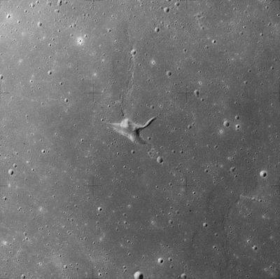
The three elongated depressions have been given individual names:
Two small craters in the vicinity of Aratus CA have also been assigned names:
Manuel is just beyond the eastern tip of Vallis Krishna, while Yoshi is just beyond the western tip of Vallis Christel. Manuel is very difficult to see, even on high-resolution photos.
The five names listed above first appeared on the Defense Mapping Agency's Topophotomaps 42A4/S1 and 42A4/S2 and were approved by the IAU in 1976. Because of a ban on the use of lettered crater names that was in effect at the time those maps were prepared, Aratus CA was given the provisional new name Lorca. The name Lorca was never approved by the IAU, despite notations to the contrary on Defense Mapping Agency maps LM-41 and LM-42, and the former name Aratus CA (which had first appeared on LAC-42, published in 1965 ) was officially re-adopted by the IAU in 2006.
Running to the north from this location is a wrinkle ridge in the surface that has been designated Dorsum Owen. To the east is a longer, parallel wrinkle-ridge named Dorsum von Cotta. Further to the north-northeast is Linné
, surrounded by a bright skirt of high-albedo
material. About the same distance to the southwest is the Montes Haemus
mountain range at the edge of the lunar mare
.
The selenographic colongitude of this grouping at dawn is 349°
Moon
The Moon is Earth's only known natural satellite,There are a number of near-Earth asteroids including 3753 Cruithne that are co-orbital with Earth: their orbits bring them close to Earth for periods of time but then alter in the long term . These are quasi-satellites and not true moons. For more...
impact crater
Impact crater
In the broadest sense, the term impact crater can be applied to any depression, natural or manmade, resulting from the high velocity impact of a projectile with a larger body...
located on the highland to the south and east of the rugged Montes Apenninus
Montes Apenninus
Montes Apenninus are a rugged mountain range on the northern part of the Moon's near side. They are named after the Apennine Mountains in Italy....
range. It is a circular, cup-shaped crater with a relatively high albedo
Albedo
Albedo , or reflection coefficient, is the diffuse reflectivity or reflecting power of a surface. It is defined as the ratio of reflected radiation from the surface to incident radiation upon it...
. To the east is the Mare Serenitatis
Mare Serenitatis
Mare Serenitatis is a lunar mare that sits just to the east of Mare Imbrium on the Moon.It is located within the Serenitatis basin, which is of the Nectarian epoch. The material surrounding the mare is of the Lower Imbrian epoch, while the mare material is of the Upper Imbrian epoch...
, and to the southwest is the somewhat larger crater Conon
Conon (crater)
Conon is a small but prominent lunar impact crater that lies in the eastern foothills of the Montes Apenninus mountain range. Just to the west of Conon is the long mountainous ridge named Mons Bradley...
. North-northeast of Aratus is the landing site of the Apollo 15
Apollo 15
Apollo 15 was the ninth manned mission in the American Apollo space program, the fourth to land on the Moon and the eighth successful manned mission. It was the first of what were termed "J missions", long duration stays on the Moon with a greater focus on science than had been possible on previous...
mission, just beyond Mons Hadley Delta.
Satellite craters
By convention these features are identified on lunar maps by placing the letter on the side of the crater mid-point that is closest to Aratus.| Aratus | Latitude | Longitude | Diameter |
|---|---|---|---|
| B | 24.2° N | 5.4° E | 7 km |
| C | 24.1° N | 9.5° E | 4 km |
| CA | 24.5° N | 11.2° E | 7 km |
| D | 24.3° N | 8.6° E | 4 km |
The following craters have been renamed by the IAU
International Astronomical Union
The International Astronomical Union IAU is a collection of professional astronomers, at the Ph.D. level and beyond, active in professional research and education in astronomy...
.
- Aratus A — See Galen (crater)Galen (crater)Galen is a small lunar impact crater that lies in the rugged region between the Montes Apenninus range to the west and the Montes Haemus in the east. It is located to the south-southeast of the crater Aratus, a slightly larger formation. Further to the west is the crater Conon, near the flanks of...
.
Aratus CA
This three-pronged feature is located in western Mare Serenitatis. It is formed from a merged group of depressions in the lunar surface, and may be a volcanic vent. The dimensions are 9.5 km × 3 km, and it is an estimated 0.4 km deep.The three elongated depressions have been given individual names:
| Feature | Coordinates Selenographic coordinates Selenographic coordinates are used to refer to locations on the surface of Earth's moon. Any position on the lunar surface can be referenced by specifying two numerical values, which are comparable to the latitude and longitude of Earth... |
Length Length In geometric measurements, length most commonly refers to the longest dimension of an object.In certain contexts, the term "length" is reserved for a certain dimension of an object along which the length is measured. For example it is possible to cut a length of a wire which is shorter than wire... |
Name source |
|---|---|---|---|
| Rima Sung-Mei | 24.6°N 11.3°E | 4.0 km | Chinese Chinese language The Chinese language is a language or language family consisting of varieties which are mutually intelligible to varying degrees. Originally the indigenous languages spoken by the Han Chinese in China, it forms one of the branches of Sino-Tibetan family of languages... masculine name |
| Vallis Christel | 24.5°N 11.0°E | 2.0 km | German German language German is a West Germanic language, related to and classified alongside English and Dutch. With an estimated 90 – 98 million native speakers, German is one of the world's major languages and is the most widely-spoken first language in the European Union.... female name |
| Vallis Krishna | 24.5°N 11.3°E | 3.0 km | Indian masculine name |
Two small craters in the vicinity of Aratus CA have also been assigned names:
| Crater | Coordinates Selenographic coordinates Selenographic coordinates are used to refer to locations on the surface of Earth's moon. Any position on the lunar surface can be referenced by specifying two numerical values, which are comparable to the latitude and longitude of Earth... |
Diameter Diameter In geometry, a diameter of a circle is any straight line segment that passes through the center of the circle and whose endpoints are on the circle. The diameters are the longest chords of the circle... |
Name source |
|---|---|---|---|
| Manuel | 24.5°N 11.3°E | 0.5 km | Spanish Spanish language Spanish , also known as Castilian , is a Romance language in the Ibero-Romance group that evolved from several languages and dialects in central-northern Iberia around the 9th century and gradually spread with the expansion of the Kingdom of Castile into central and southern Iberia during the... masculine name |
| Yoshi | 24.6°N 11.0°E | 1 km | Japanese Japanese language is a language spoken by over 130 million people in Japan and in Japanese emigrant communities. It is a member of the Japonic language family, which has a number of proposed relationships with other languages, none of which has gained wide acceptance among historical linguists .Japanese is an... masculine name |
Manuel is just beyond the eastern tip of Vallis Krishna, while Yoshi is just beyond the western tip of Vallis Christel. Manuel is very difficult to see, even on high-resolution photos.
The five names listed above first appeared on the Defense Mapping Agency's Topophotomaps 42A4/S1 and 42A4/S2 and were approved by the IAU in 1976. Because of a ban on the use of lettered crater names that was in effect at the time those maps were prepared, Aratus CA was given the provisional new name Lorca. The name Lorca was never approved by the IAU, despite notations to the contrary on Defense Mapping Agency maps LM-41 and LM-42, and the former name Aratus CA (which had first appeared on LAC-42, published in 1965 ) was officially re-adopted by the IAU in 2006.
Running to the north from this location is a wrinkle ridge in the surface that has been designated Dorsum Owen. To the east is a longer, parallel wrinkle-ridge named Dorsum von Cotta. Further to the north-northeast is Linné
Linné (crater)
Linné is a small lunar impact crater located in the western Mare Serenitatis. The mare around this feature is virtually devoid of other features of interest. The nearest named crater is Banting to the east-southeast....
, surrounded by a bright skirt of high-albedo
Albedo
Albedo , or reflection coefficient, is the diffuse reflectivity or reflecting power of a surface. It is defined as the ratio of reflected radiation from the surface to incident radiation upon it...
material. About the same distance to the southwest is the Montes Haemus
Montes Haemus
Montes Haemus is a curving range of mountains that forms the southwestern edge of the Mare Serenitatis basin on the Moon. They form a less prominent mirror image of the Montes Apenninus range to the west, and curve up to nearly join at the northern end. The eastern edge terminates with the...
mountain range at the edge of the lunar mare
Lunar mare
The lunar maria are large, dark, basaltic plains on Earth's Moon, formed by ancient volcanic eruptions. They were dubbed maria, Latin for "seas", by early astronomers who mistook them for actual seas. They are less reflective than the "highlands" as a result of their iron-rich compositions, and...
.
The selenographic colongitude of this grouping at dawn is 349°