

Angelino Dulcert
Encyclopedia
Angelino Dulcert probably also the same person known as Angelino de Dalorto (fl.
1320s), and who's real name was probably Angelino de Dulceto or Dulceti or possibly Angelí Dolcet, was an Italian
-Majorcan cartographer.
He is responsible for two notable 14th C. portolan chart
s, the "Dalorto" chart of 1325 and the "Dulcert" chart of 1339. The latter is the first portolan known to have been produced in Palma, and considered the founding piece of the Majorcan cartographic school
. He is also believed to be the author of a third undated and unsigned chart held in London.
, who trained in Genoa
and subsequently emigrated to Majorca some time in the 1320s or 1330s.
Angelino 'Dalorto' was once thought connected to the notable Genoese
"Dell' Orto" family. The latter were known to be active in the Black Sea
and the Asian trade
, e.g. in 1340, Pope Benedict XII
speaks of receiving a Petraneus da Lorto, former Genoese governor of Caffa and emissary of Uzbeg Khan
of the Golden Horde
. It was conjectured that Angelino Dalorto moved to Majorca, possibly as a commercial agent for his family's trading house, and took up the name 'Dulcert' as a more Catalan
-sounding version of his surname.
However, more recent readings claim the signatures on the maps have been previously misread, that the 'Dalorto' in the 1325 chart should be read as "Dulceto" and the "Dulcert" in the 1339 chart is in fact "Dulceti". This implies Angelino originates from Dulceto, or Dulcedo
, a small Italian town in Liguria
, a little down the coast from Genoa
. This reinforces the common assumption that he was an Italian immigrant who settled in Majorca. However, others have noted the existence of the "Dolcet" surname in earlier Majorcan records.
The identity and nationality of Angelino Dulceti/Dolcet/Dalorto/Dulcert has been a longstanding item of contention between scholars, often attenuated by nationalist sentiments. Scholars who seek to claim Dulcert to be wholly of Catalan
, nationality have tended to argue that Dalorto and Dulcert are two different men, that the Catalan Dulcert might simply have been "inspired" by the Genoese Dalorto. Pujades (2007), touching only briefly on the controversy, concludes
collection in Florence
. Its signature was traditionally read as "Hoc opus fecit Angelinus de Dalorto ano dñi MCCXXV de mense martii composuit hoc" (and since re-read as "Angelinus de Dulceto'" and "ano dñi MCCXXX", thus the revision of the name to "Dulceto" and the year to 1330).
In many ways, the 1325 Dalorto portolan marks a transition point in European portolans, between the Genoese and Majorcan cartographic schools. For the most part, Dalorto follows the restrained coast-focused Italian style, exemplified by the early portolans of his Genoese predecessor Pietro Vesconte
, but he also begins moving away from its sparseness by illustrating inland details, such as miniature cities, mountain ranges and rivers, a tendency will flourish in the later Majorcan school. Indeed, some of Dalorto's details here presage the standard Majorcan stylings (e.g. Red Sea
colored red, the Atlas Mountains
shaped like a palm tree, the chicken-foot Alps
, the Danube
's "hillocks").
Among its advances in geographic knowledge, the Dalorto map gives a better picture of northern Europe (particularly the Baltic Sea
) than its predecessors.
The Dalorto chart is also the first to depict the legendary island of Brasil, as circular disk-shaped island southwest of Ireland
. It is denoted by the caption "Insula de monotonis siue de brazile" ("isle of sheep (?) or of brasil").
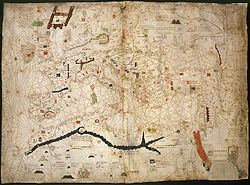 Angelino "Dulcert" is known for a portolan chart dated 1339 and held by the Bibliotheque Nationale de France
in Paris
, France (B.696). Its signature reads: "ano MCCCXXXVIIII mense Augusto Angelino Dulcert in civitate Maioricarum composuit". Unlike its predecessor, it is composed not on a single vellum
, but on two parchment
pages, joined together as a single map, measuring 75 × 102 cm.
Made in Palma, the Dulcert 1339 map is considered the founding piece of the Majorcan cartographic school
. Although some of its features were already presaged in the Dalorto map, it goes further in the inland illustrations, in particular including miniature illustrations of people.
In many ways, the Dulcert 1339 map is very similar to the 1325 Dalorto map. On the other hand, the portolan's keys and legends are written in Latin
, and it contains features not usually found on Genoese
or Venetian
portolans.
The 1339 Dulcert map is notable for giving the first modern depiction of the island of Lanzarote
, one of the Canary Islands
, as Insula de Lanzarotus Marocelus, a reference to the Genoese navigator Lancelotto Malocello
, and affixes a Genoese shield to mark the island (a custom which will be retained by future mapmakers).
Dulcert also introduces what seems like the Madeira
islands, named here as Capraria and Canaria (legendary names for two of the Fortunate Islands of classical antiquity
, as found in, e.g. Ptolemy
).
in London, UK (Add.MS.25691). It thought to have been composed sometime in the 1340s, although some scholars have suggested it may even precede the Dalorto 1325 map.
Floruit
Floruit , abbreviated fl. , is a Latin verb meaning "flourished", denoting the period of time during which something was active...
1320s), and who's real name was probably Angelino de Dulceto or Dulceti or possibly Angelí Dolcet, was an Italian
Italian people
The Italian people are an ethnic group that share a common Italian culture, ancestry and speak the Italian language as a mother tongue. Within Italy, Italians are defined by citizenship, regardless of ancestry or country of residence , and are distinguished from people...
-Majorcan cartographer.
He is responsible for two notable 14th C. portolan chart
Portolan chart
Portolan charts are navigational maps based on realistic descriptions of harbours and coasts. They were first made in the 14th century in Italy, Portugal and Spain...
s, the "Dalorto" chart of 1325 and the "Dulcert" chart of 1339. The latter is the first portolan known to have been produced in Palma, and considered the founding piece of the Majorcan cartographic school
Majorcan cartographic school
The Majorcan cartographic school is the term coined by historians to refer to the collection of cartographers, cosmographers and navigational instrument-makers that flourished in Majorca in the 14th and 15th Centuries. The label is usually inclusive of those who worked in mainland Catalonia...
. He is also believed to be the author of a third undated and unsigned chart held in London.
Background
Virtually nothing is known of Angelino Dulceti/Dolcet/Dalorto/Dulcert. A common assumption is that he was an Italian of LiguriaLiguria
Liguria is a coastal region of north-western Italy, the third smallest of the Italian regions. Its capital is Genoa. It is a popular region with tourists for its beautiful beaches, picturesque little towns, and good food.-Geography:...
, who trained in Genoa
Genoa
Genoa |Ligurian]] Zena ; Latin and, archaically, English Genua) is a city and an important seaport in northern Italy, the capital of the Province of Genoa and of the region of Liguria....
and subsequently emigrated to Majorca some time in the 1320s or 1330s.
Angelino 'Dalorto' was once thought connected to the notable Genoese
Republic of Genoa
The Most Serene Republic of Genoa |Ligurian]]: Repúbrica de Zêna) was an independent state from 1005 to 1797 in Liguria on the northwestern Italian coast, as well as Corsica from 1347 to 1768, and numerous other territories throughout the Mediterranean....
"Dell' Orto" family. The latter were known to be active in the Black Sea
Black Sea
The Black Sea is bounded by Europe, Anatolia and the Caucasus and is ultimately connected to the Atlantic Ocean via the Mediterranean and the Aegean seas and various straits. The Bosphorus strait connects it to the Sea of Marmara, and the strait of the Dardanelles connects that sea to the Aegean...
and the Asian trade
Pax Mongolica
The Pax Mongolica is a Latin phrase meaning "Mongol Peace" coined by Western scholars to describe the stabilizing effects of the conquests of the Mongol Empire on the social, cultural, and economic life of the inhabitants of the vast Eurasian territory that the Mongols conquered in the 13th and...
, e.g. in 1340, Pope Benedict XII
Pope Benedict XII
Pope Benedict XII , born Jacques Fournier, the third of the Avignon Popes, was Pope from 1334 to 1342.-Early life:...
speaks of receiving a Petraneus da Lorto, former Genoese governor of Caffa and emissary of Uzbeg Khan
Uzbeg Khan
Sultan Mohammed Öz-Beg, better known as Uzbeg or Ozbeg , was the longest-reigning khan of the Golden Horde, under whose rule the state reached its zenith...
of the Golden Horde
Golden Horde
The Golden Horde was a Mongol and later Turkicized khanate that formed the north-western sector of the Mongol Empire...
. It was conjectured that Angelino Dalorto moved to Majorca, possibly as a commercial agent for his family's trading house, and took up the name 'Dulcert' as a more Catalan
Catalan language
Catalan is a Romance language, the national and only official language of Andorra and a co-official language in the Spanish autonomous communities of Catalonia, the Balearic Islands and Valencian Community, where it is known as Valencian , as well as in the city of Alghero, on the Italian island...
-sounding version of his surname.
However, more recent readings claim the signatures on the maps have been previously misread, that the 'Dalorto' in the 1325 chart should be read as "Dulceto" and the "Dulcert" in the 1339 chart is in fact "Dulceti". This implies Angelino originates from Dulceto, or Dulcedo
Dulcedo
Dulcedo is a butterfly genus from the subfamily Satyrinae in the family Nymphalidae....
, a small Italian town in Liguria
Liguria
Liguria is a coastal region of north-western Italy, the third smallest of the Italian regions. Its capital is Genoa. It is a popular region with tourists for its beautiful beaches, picturesque little towns, and good food.-Geography:...
, a little down the coast from Genoa
Genoa
Genoa |Ligurian]] Zena ; Latin and, archaically, English Genua) is a city and an important seaport in northern Italy, the capital of the Province of Genoa and of the region of Liguria....
. This reinforces the common assumption that he was an Italian immigrant who settled in Majorca. However, others have noted the existence of the "Dolcet" surname in earlier Majorcan records.
The identity and nationality of Angelino Dulceti/Dolcet/Dalorto/Dulcert has been a longstanding item of contention between scholars, often attenuated by nationalist sentiments. Scholars who seek to claim Dulcert to be wholly of Catalan
Catalan people
The Catalans or Catalonians are the people from, or with origins in, Catalonia that form a historical nationality in Spain. The inhabitants of the adjacent portion of southern France are sometimes included in this definition...
, nationality have tended to argue that Dalorto and Dulcert are two different men, that the Catalan Dulcert might simply have been "inspired" by the Genoese Dalorto. Pujades (2007), touching only briefly on the controversy, concludes
Dalorto 1325 Map
Angelino "Dalorto" is known for a portolan chart commonly dated 1325 (now revised to 1330), privately held by the Prince CorsiniCorsini
Corsini is the name of a Florentine princely family.-History:The founder is said to be Neri Corsini, who came to prominence circa 1170. The family are likely to have originated from Corsica, during the time when the Republic of Pisa was ruling the island. Initially the family was known as Corso ...
collection in Florence
Florence
Florence is the capital city of the Italian region of Tuscany and of the province of Florence. It is the most populous city in Tuscany, with approximately 370,000 inhabitants, expanding to over 1.5 million in the metropolitan area....
. Its signature was traditionally read as "Hoc opus fecit Angelinus de Dalorto ano dñi MCCXXV de mense martii composuit hoc" (and since re-read as "Angelinus de Dulceto'" and "ano dñi MCCXXX", thus the revision of the name to "Dulceto" and the year to 1330).
In many ways, the 1325 Dalorto portolan marks a transition point in European portolans, between the Genoese and Majorcan cartographic schools. For the most part, Dalorto follows the restrained coast-focused Italian style, exemplified by the early portolans of his Genoese predecessor Pietro Vesconte
Pietro Vesconte
Pietro Vesconte was a Genoese cartographer and geographer. A pioneer of the field of the portolan chart, he influenced Italian and Catalan mapmaking throughout the fourteenth and fifteenth centuries. He appears to have been the first professional mapmaker to sign and date his works...
, but he also begins moving away from its sparseness by illustrating inland details, such as miniature cities, mountain ranges and rivers, a tendency will flourish in the later Majorcan school. Indeed, some of Dalorto's details here presage the standard Majorcan stylings (e.g. Red Sea
Red Sea
The Red Sea is a seawater inlet of the Indian Ocean, lying between Africa and Asia. The connection to the ocean is in the south through the Bab el Mandeb strait and the Gulf of Aden. In the north, there is the Sinai Peninsula, the Gulf of Aqaba, and the Gulf of Suez...
colored red, the Atlas Mountains
Atlas Mountains
The Atlas Mountains is a mountain range across a northern stretch of Africa extending about through Morocco, Algeria, and Tunisia. The highest peak is Toubkal, with an elevation of in southwestern Morocco. The Atlas ranges separate the Mediterranean and Atlantic coastlines from the Sahara Desert...
shaped like a palm tree, the chicken-foot Alps
Alps
The Alps is one of the great mountain range systems of Europe, stretching from Austria and Slovenia in the east through Italy, Switzerland, Liechtenstein and Germany to France in the west....
, the Danube
Danube
The Danube is a river in the Central Europe and the Europe's second longest river after the Volga. It is classified as an international waterway....
's "hillocks").
Among its advances in geographic knowledge, the Dalorto map gives a better picture of northern Europe (particularly the Baltic Sea
Baltic Sea
The Baltic Sea is a brackish mediterranean sea located in Northern Europe, from 53°N to 66°N latitude and from 20°E to 26°E longitude. It is bounded by the Scandinavian Peninsula, the mainland of Europe, and the Danish islands. It drains into the Kattegat by way of the Øresund, the Great Belt and...
) than its predecessors.
The Dalorto chart is also the first to depict the legendary island of Brasil, as circular disk-shaped island southwest of Ireland
Ireland
Ireland is an island to the northwest of continental Europe. It is the third-largest island in Europe and the twentieth-largest island on Earth...
. It is denoted by the caption "Insula de monotonis siue de brazile" ("isle of sheep (?) or of brasil").
Dulcert 1339 Map
Bibliothèque nationale de France
The is the National Library of France, located in Paris. It is intended to be the repository of all that is published in France. The current president of the library is Bruno Racine.-History:...
in Paris
Paris
Paris is the capital and largest city in France, situated on the river Seine, in northern France, at the heart of the Île-de-France region...
, France (B.696). Its signature reads: "ano MCCCXXXVIIII mense Augusto Angelino Dulcert in civitate Maioricarum composuit". Unlike its predecessor, it is composed not on a single vellum
Vellum
Vellum is mammal skin prepared for writing or printing on, to produce single pages, scrolls, codices or books. It is generally smooth and durable, although there are great variations depending on preparation, the quality of the skin and the type of animal used...
, but on two parchment
Parchment
Parchment is a thin material made from calfskin, sheepskin or goatskin, often split. Its most common use was as a material for writing on, for documents, notes, or the pages of a book, codex or manuscript. It is distinct from leather in that parchment is limed but not tanned; therefore, it is very...
pages, joined together as a single map, measuring 75 × 102 cm.
Made in Palma, the Dulcert 1339 map is considered the founding piece of the Majorcan cartographic school
Majorcan cartographic school
The Majorcan cartographic school is the term coined by historians to refer to the collection of cartographers, cosmographers and navigational instrument-makers that flourished in Majorca in the 14th and 15th Centuries. The label is usually inclusive of those who worked in mainland Catalonia...
. Although some of its features were already presaged in the Dalorto map, it goes further in the inland illustrations, in particular including miniature illustrations of people.
In many ways, the Dulcert 1339 map is very similar to the 1325 Dalorto map. On the other hand, the portolan's keys and legends are written in Latin
Latin
Latin is an Italic language originally spoken in Latium and Ancient Rome. It, along with most European languages, is a descendant of the ancient Proto-Indo-European language. Although it is considered a dead language, a number of scholars and members of the Christian clergy speak it fluently, and...
, and it contains features not usually found on Genoese
Genoa
Genoa |Ligurian]] Zena ; Latin and, archaically, English Genua) is a city and an important seaport in northern Italy, the capital of the Province of Genoa and of the region of Liguria....
or Venetian
Venice
Venice is a city in northern Italy which is renowned for the beauty of its setting, its architecture and its artworks. It is the capital of the Veneto region...
portolans.
The 1339 Dulcert map is notable for giving the first modern depiction of the island of Lanzarote
Lanzarote
Lanzarote , a Spanish island, is the easternmost of the autonomous Canary Islands, in the Atlantic Ocean, approximately 125 km off the coast of Africa and 1,000 km from the Iberian Peninsula. Covering 845.9 km2, it stands as the fourth largest of the islands...
, one of the Canary Islands
Canary Islands
The Canary Islands , also known as the Canaries , is a Spanish archipelago located just off the northwest coast of mainland Africa, 100 km west of the border between Morocco and the Western Sahara. The Canaries are a Spanish autonomous community and an outermost region of the European Union...
, as Insula de Lanzarotus Marocelus, a reference to the Genoese navigator Lancelotto Malocello
Lancelotto Malocello
Lancelotto Malocello was a Genoese navigator , who gave his name to the island of Lanzarote, one of the Canary Islands....
, and affixes a Genoese shield to mark the island (a custom which will be retained by future mapmakers).
Dulcert also introduces what seems like the Madeira
Madeira
Madeira is a Portuguese archipelago that lies between and , just under 400 km north of Tenerife, Canary Islands, in the north Atlantic Ocean and an outermost region of the European Union...
islands, named here as Capraria and Canaria (legendary names for two of the Fortunate Islands of classical antiquity
Classical antiquity
Classical antiquity is a broad term for a long period of cultural history centered on the Mediterranean Sea, comprising the interlocking civilizations of ancient Greece and ancient Rome, collectively known as the Greco-Roman world...
, as found in, e.g. Ptolemy
Ptolemy
Claudius Ptolemy , was a Roman citizen of Egypt who wrote in Greek. He was a mathematician, astronomer, geographer, astrologer, and poet of a single epigram in the Greek Anthology. He lived in Egypt under Roman rule, and is believed to have been born in the town of Ptolemais Hermiou in the...
).
London c.1340 map
In the 20th C., a third map has emerged, which is unsigned and which has become commonly attributed to Angelino Dulceti/Dolcet/Dalorto/Dulcert on account of its features. It is held by the British LibraryBritish Library
The British Library is the national library of the United Kingdom, and is the world's largest library in terms of total number of items. The library is a major research library, holding over 150 million items from every country in the world, in virtually all known languages and in many formats,...
in London, UK (Add.MS.25691). It thought to have been composed sometime in the 1340s, although some scholars have suggested it may even precede the Dalorto 1325 map.
External links
- Online copy of Dalorto 1325 chart at Internet Culturale
- www.cresquesproject.net --Translation in English of the works of Riera i Sans and Gabriel Llompart on the Jewish Majorcan Map-makers of the Late Middle Ages
Sources
- Beazley, C.R. (1906) The Dawn of Modern Geography. London. vol. 3
- Blázquez, Antonio (1906) "Estudio acerca de la cartografía española en la Edad Media, acompañado de varios mapas", Boletín Real de la Sociedad Geográfica, , vol. 48, p.190-237
- Campbell, T. (1987) "Portolan Charts from the Late Thirteenth Century to 1500". The History of Cartography. Volume 1. Chicago: University of Chicago Press, pp. 371–463.
- Campbell, T. (2011) "Complete chronological listing of works assigned to the period pre-1501 (with a note of high quality reproductions and place-name lists)" [ online]
- Caraci, G. (1959) Italiani e Catalani nella primitiva cartografia medievale, Rome: 'Universita degli studi.
- Caraci, G. (1960) "A Preliminary Reply to Herr Winter", Imago Mundi, Vol. 15, p. 113-14.
- Crone, G.R. (1962) "Origin of Early Marine Charts", The Geographical Journal", vol. 128 (1), p.114.
- Duro, Cesáreo Fernández (1892) "Los cartógrafos mallorquines: Angelino Dulceti, Jafudá Cresques", Boletín de la Sociedad Geográfica de Madrid, Vol.31, p.283-94
- Garcia Camarero, E. (1959) "La Escuela Cartografica de Mallorca", Revista General de Marina, vol. 157, p.10-22 online (PDF)
- Hinks. A.R. (1929) The portolan chart of Angellino de Dalorto, MCCCXXV, in the collection of Prince Corsini at Florence, London: Royal Geographical Society.
- Llabrés, Gabriel (1890) "Cartógrafos Mallorquines: ¿Fué mallorquin Angelinus Dulceti?", Boletín de la Sociedad Arqueológica Luliana,, November, p.347
- Magnaghi, A. (1899) "Il Mappamondo del Genovese Angellinus del Dalorto (1325): Contributo alla storia della cartografia mediovale", Atti del terzo Congresso geografico italiano tenuto in Firenze dal 12 al 17 aprile 1898, vol. 2, Florence: M. Ricci, p.506-
- Magnaghi, A. (1909) "Sulle origini del portolano normale nel Medio Evo e della Cartografia dell'Europa occidentale", in Memorie geografiche, vol. 4, no.8, p.115-80.
- Marcel, Gabriel (1887) "Note sur une carte catalane de Dulceri datée de 1339", Comptes rendus des séances de la Société de Géographie. (p.28-35) (Offprint published 1887, titled Note sur une carte catalane de Dulceri antérieure à l'Atlas Catalan de 1375, lue à la Société de Géographie de Paris dans la seance du 7 janvier 1887" Paris: Société de géographie.
- Fridtjof NansenFridtjof NansenFridtjof Wedel-Jarlsberg Nansen was a Norwegian explorer, scientist, diplomat, humanitarian and Nobel Peace Prize laureate. In his youth a champion skier and ice skater, he led the team that made the first crossing of the Greenland interior in 1888, and won international fame after reaching a...
(1911) In Northern Mists; Arctic exploration in early times. New York: F.A. Stokes. vol. 1, vol. 2
- Pujades i Bataller, Ramon J. (2007) Les cartes portolanes: la representació medieval d'una mar solcada. Barcelona.
- Petrus Amat di S. Filippo (1888) "Recenti Ritrovimenti di Carte Nautiche in Parigi in Londra ed in Firenze",Bollettino della Società geografica italiana, Vol. 25, p.268-
- Winter, Heinrich (1958) "Catalan Portolan Maps and their place in the total view of cartographic development", Imago Mundi, Vol.11, p. 1-12