
Amphoe Mueang Yasothon
Encyclopedia
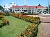
Mueang Yasothon is the capital district of the province of Yasothon
in northeastern Thailand
on the Chi River
. Subdistrict
Nai Mueang determines the city limits
of the town of Yasothon
.
, and several others set off to come live with the king in Champassak. Along the way they arrived at a jungle where spirits dwelt, and seeing that it was a good place, they built a village there next to the grounds of an abandoned wat
. They called it Wat Singh Tha , which remains to this day. The village they called Ban Singh Tha . Singh
is a mythical lion; Tha means pose.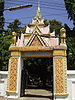 A Fine Arts Dept. marker for a chedi
erected by Wat Singh Tha says that, during the Thonburi
Era, grandson Kham Su called the settlement Ban Singh Thong . The wat
, which had been deserted with dense jungle blocking the way to the river landing, was re-built and renamed after the new village. The change from Thong (Gold) to Tha was influenced by two factors: Tha means port or landing and also means pose with many connotations. Thus the change in name to Singh Tha means Port Lion, and also Imposing Lion such as those posed on the Lion Gate, and on pedestals on the temple grounds.
In 1814, King Rama II renamed Ban Singh Tha to Yasothon and raised its status to mueang
.
, Kut Chum
, Pa Tio
and Kham Khuean Kaeo
of Yasothon Province, Phanom Phrai
and Selaphum
of Roi Et Province
.
), which are further subdivided into 190 village groups (muban
). The town (thesaban mueang) Yasothon
covers the whole tambon Nai Mueang. There are further 17 Tambon administrative organizations (TAO).
 The Yasothon District Office is located at:
Chaeng Sanit Road
T. Nai Mueang
A. Mueang Yasothon
Yasothon 35000
The secondary schools in Mueang Yasothon are:
College in Mueang Yasothon
, 2 joss house
s and 1 mosque
, along with 1 school/worship center of the Bahá'í Faith
, Roman Catholic, Church of Christ
, and The Church of Jesus Christ of Latter-day Saints.
is located west of the city proper in Ban Doet Tambon Doet, on Route 23 (Chaeng Sanit Road ). The camp has been home to the Royal Thai Army Sixteenth Infantry Regiment since 23 December 1985. The camp also hosts the Bodindecha Golf Club, which is open to the public. 15.907329°N 104.061321°W
Yasothon Province
Yasothon is one of the provinces of Thailand, located in the North-East of Thailand on the Chi River. Neighboring provinces are Mukdahan, Amnat Charoen, Ubon Ratchathani, Sisaket and Roi Et.-Geography:...
in northeastern Thailand
Isan
Isan is the northeastern region of Thailand. It is located on the Khorat Plateau, bordered by the Mekong River to the north and east, by Cambodia to the southeast and the Prachinburi mountains south of Nakhon Ratchasima...
on the Chi River
Chi River
The Chi River is the longest river in Thailand; it extends 765 km, but carries less water than the second longest river, the Mun. In the Isan dialect of this region, and also in the adjacent language Lao, the name of the river is actually pronounced "Nam Si" but the transliteration Chi...
. Subdistrict
Tambon
Tambon is a local government unit in Thailand. Below district and province , they form the third administrative subdivision level. As of the 2009 there are 7255 tambon, not including the 169 khwaeng of Bangkok, which are set at the same administrative level, thus every district contains 8-10 tambon...
Nai Mueang determines the city limits
City limits
The terms city limits and city boundary refer to the defined boundary or border of a city. The area within the city limits is sometimes called the city proper. The terms town limits/boundary and village limits/boundary mean the same as city limits/boundary, but apply to towns and villages...
of the town of Yasothon
Yasothon
Yasothon is a town on the Chi River in the northeastern region of Thailand. It is the capital and administrative center of Yasothon Province and seat of its City District. Within this district, subdistrict Nai Mueang comprises the bounds of the town proper, which had a population of 21,134 in 2005...
.
History
According to the chronicles of Mueang Yasothon, in 1795 Phra Chao Worawongsa (Phra Wo), Minister of VientianeVientiane
-Geography:Vientiane is situated on a bend of the Mekong river, which forms the border with Thailand at this point.-Climate:Vientiane features a tropical wet and dry climate with a distinct monsoon season and a dry season. Vientiane’s dry season spans from November through March. April marks the...
, and several others set off to come live with the king in Champassak. Along the way they arrived at a jungle where spirits dwelt, and seeing that it was a good place, they built a village there next to the grounds of an abandoned wat
Wat
A wat is a monastery temple in Cambodia, Thailand, or Laos. The word "wat" means "school".- Introduction :...
. They called it Wat Singh Tha , which remains to this day. The village they called Ban Singh Tha . Singh
Singh
Also see SinhaSingh is a common title, middle name, or surname in Northern India and South India used by sikhs warriors and kings. eg. Man Singh I, Maharana Pratap Singh. It is derived from the Sanskrit word Siṃha meaning "lion and used by Ahir kings of Nepal". It is also used in Sri Lanka by...
is a mythical lion; Tha means pose.
Stupa
A stupa is a mound-like structure containing Buddhist relics, typically the remains of Buddha, used by Buddhists as a place of worship....
erected by Wat Singh Tha says that, during the Thonburi
Thonburi
Thon Buri is an area of modern Bangkok. It was capital of Thailand from 1767 to 1782, during the reign of King Taksin, after the previous capital Ayutthaya was sacked by the Burmese. It is located on the opposite bank of Chao Phraya River to Bangkok...
Era, grandson Kham Su called the settlement Ban Singh Thong . The wat
Wat
A wat is a monastery temple in Cambodia, Thailand, or Laos. The word "wat" means "school".- Introduction :...
, which had been deserted with dense jungle blocking the way to the river landing, was re-built and renamed after the new village. The change from Thong (Gold) to Tha was influenced by two factors: Tha means port or landing and also means pose with many connotations. Thus the change in name to Singh Tha means Port Lion, and also Imposing Lion such as those posed on the Lion Gate, and on pedestals on the temple grounds.
In 1814, King Rama II renamed Ban Singh Tha to Yasothon and raised its status to mueang
Mueang
Mueang were historical semi-independent city-states or principalities in present-day Thailand, Laos, parts of northern Vietnam and the Shan State of Myanmar. Smaller Mueang were subordinate to more powerful neighboring Mueang, which in turn were subordinate to the central king, as described in...
.
Geography
Neighboring districts are (from the north clockwise) Sai MunAmphoe Sai Mun
-History:Sai Mun village was formerly a village of Amphoe Yasothon, when it was still part of Ubon Ratchathani Province. The village changed locations around the time of King Rama V when an epidemic caused villagers to abandon their homes and start a new village two kilometers away...
, Kut Chum
Amphoe Kut Chum
Kut Chum is a district of Yasothon Province in northeastern Thailand.-History:The village of Kut Chum was established in 1912. A minor district Kut Chum was established on August 1, 1961...
, Pa Tio
Amphoe Pa Tio
-History:Around 1889 there was an influx of Lao settlers into the Isan region after a large area of Thailand east of the Mekong River was ceded to the French. Among the villages established in this migration was Ban Pa Tio....
and Kham Khuean Kaeo
Amphoe Kham Khuean Kaeo
Kham Khuean Kaeo is a district of Yasothon Province in northeastern Thailand.-History:In 1917, the district was renamed to Lumphuk after its central subdistrict...
of Yasothon Province, Phanom Phrai
Amphoe Phanom Phrai
Phanom Phrai is a district in the southeastern part of Roi Et Province, northeastern Thailand.-Geography:Neighboring districts are Nong Hi, Suwannaphum, At Samat, Selaphum of Roi Et Province, Mueang Yasothon, Kham Khuean Kaeo, Maha Chana Chai of Yasothon Province and Sila Lat of Sisaket...
and Selaphum
Amphoe Selaphum
Selaphum is a district in the eastern part of Roi Et Province, northeastern Thailand.-Geography:Neighboring districts are Phanom Phrai, At Samat, Thung Khao Luang, Thawat Buri, Chiang Khwan, Pho Chai, Phon Thong and Nong Phok of Roi Et Province, Kut Chum, Sai Mun and Mueang Yasothon of Yasothon...
of Roi Et Province
Roi Et Province
Roi Et is one of the provinces of Thailand, located in the North-East of Thailand. Neighboring Provinces are Kalasin, Mukdahan, Yasothon, Sisaket, Surin and Maha Sarakham....
.
Administration
The district is subdivided into 18 subdistricts (tambonTambon
Tambon is a local government unit in Thailand. Below district and province , they form the third administrative subdivision level. As of the 2009 there are 7255 tambon, not including the 169 khwaeng of Bangkok, which are set at the same administrative level, thus every district contains 8-10 tambon...
), which are further subdivided into 190 village groups (muban
Muban
Muban is the lowest administrative subdivision of Thailand. Usually translated as village, they are the subdivision of tambon. As of 2008, there are 74944 administrative villages in Thailand. As of the 1990 census, the average village consisted of 144 households or 746 persons.A muban does not...
). The town (thesaban mueang) Yasothon
Yasothon
Yasothon is a town on the Chi River in the northeastern region of Thailand. It is the capital and administrative center of Yasothon Province and seat of its City District. Within this district, subdistrict Nai Mueang comprises the bounds of the town proper, which had a population of 21,134 in 2005...
covers the whole tambon Nai Mueang. There are further 17 Tambon administrative organizations (TAO).
|
|
District office
Chaeng Sanit Road
T. Nai Mueang
A. Mueang Yasothon
Yasothon 35000
Education
Private school in Mueang Yasothon:- Santitham Wittayakom Primary School (Thai) (Baha'IBahá'í FaithThe Bahá'í Faith is a monotheistic religion founded by Bahá'u'lláh in 19th-century Persia, emphasizing the spiritual unity of all humankind. There are an estimated five to six million Bahá'ís around the world in more than 200 countries and territories....
) โรงเรียนสันติธรรมวิทยาคม (บาไฮ)
The secondary schools in Mueang Yasothon are:
- Yasothon Phitthayakhom School (โรงเรียนยโสธรพิทยาคม) (Thai)
- Yasothon Phitthayasan School (โรงเรียนยโสธรพิทยาสรรค์) (Thai)
College in Mueang Yasothon
- Yasothon Technical College วิทยาลัยเทคนิคยโสธร (Thai-English)
Religion
Mueang Yasothon is home to 151 watWat
A wat is a monastery temple in Cambodia, Thailand, or Laos. The word "wat" means "school".- Introduction :...
, 2 joss house
Joss house
A Shenist temple or Chinese folk temple is a place for worshiping the variety of indigenous Chinese shen from Chinese folk religion and Chinese mythology....
s and 1 mosque
Islam in Thailand
Islam is a minority faith in Thailand with statistics suggesting a population of anywhere from 500,000 to 1.2 million Most Thai Muslims belong to the Sunni sect, although Thailand has a very diverse and developing population which includes immigrants from around the world.-Demographics &...
, along with 1 school/worship center of the Bahá'í Faith
Bahá'í Faith
The Bahá'í Faith is a monotheistic religion founded by Bahá'u'lláh in 19th-century Persia, emphasizing the spiritual unity of all humankind. There are an estimated five to six million Bahá'ís around the world in more than 200 countries and territories....
, Roman Catholic, Church of Christ
Church of Christ
Churches of Christ are autonomous Christian congregations associated with one another through common beliefs and practices. They seek to base doctrine and practice on the Bible alone, and seek to be New Testament congregations as originally established by the authority of Christ. Historically,...
, and The Church of Jesus Christ of Latter-day Saints.
Military
Camp BodindechaBodindecha
Chao Phraya Bodindecha was one of the most prominent political and military figures of the early Bangkok Rattanakosin Kingdom. Bodindecha was both chancellor and military general during the reign of King Rama III...
is located west of the city proper in Ban Doet Tambon Doet, on Route 23 (Chaeng Sanit Road ). The camp has been home to the Royal Thai Army Sixteenth Infantry Regiment since 23 December 1985. The camp also hosts the Bodindecha Golf Club, which is open to the public. 15.907329°N 104.061321°W
External links
- Official government page of Mueang Yasothon