
Amboy Crater
Encyclopedia
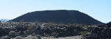
Amboy Crater and Lava Field is an extinct North America
n cinder cone
type of volcano
that rises above a 70 square kilometres (27 sq mi) lava field
in southern California
. They are located in the Mojave Desert
equidistant and about 75 miles (120.7 km) between Barstow
to the west and Needles
to the east, and 2.5 miles (4 km) southwest of historic U.S. Route 66
, in San Bernardino County, California
. Amboy Crater and Lava Field were designated the "Amboy Crater National Natural Landmark
" in May, 1973.
and the Route 66-National Trails Highway. The Bullion Mountains
are to the west, and Bristol Mountains
to the northeast.
crater is estimated to be around 6,000 years old and was formed in layers of mostly vesicular pahoehoe - possibly in the Holocene
geological period. The interior has a lava lake
. Lava flows as old as Amboy Crater itself blanket the surrounding area. According to the BLM interpretive sign the last eruption could have been as recently as 500 years ago.
The crater is 944 ft (288 m) above sea level, about 250 ft (76 m) above the surrounding basalt
lava plain
s. The scenic and solitary Amboy Crater was a popular sight and stop for travelers on U.S. Route 66 in California
before the opening of Interstate 40
in 1973. Other than a stretch of U.S. Route 66 in New Mexico
, Amboy Crater was one of few extinct volcanoes along the entire route, so generations of U.S. Route 66
travelers from the 1920s through the 1960s could boast that they had climbed a real volcano
. Visits decreased after I-40 opened, but have increased in recent years with the nearby Mitchell Caverns
, Mojave National Preserve
,
and renewed historical tourism interest in "old Route 66."
(BLM) recommends using the western Cone Trail to reach the volcano peak's rim, a steep and rocky hiking
trail
. The trailhead
is at the Amboy Crater day use parking area, along with shaded and open picnic
tables, and public restrooms
. Regular desert precautions apply here: being alert for rattlesnake
s and old military explosives, and having a hat, sunscreen, sturdy shoes, and abundant drinking water. Educational and organized groups are advised to contact the BLM
before heading out to Amboy Crater.
album Snakes & Arrows Live
.
North America
North America is a continent wholly within the Northern Hemisphere and almost wholly within the Western Hemisphere. It is also considered a northern subcontinent of the Americas...
n cinder cone
Cinder cone
According to the , Cinder Cone is the proper name of 1 cinder cone in Canada and 7 cinder cones in the United States:In Canada: Cinder Cone In the United States:...
type of volcano
Volcano
2. Bedrock3. Conduit 4. Base5. Sill6. Dike7. Layers of ash emitted by the volcano8. Flank| 9. Layers of lava emitted by the volcano10. Throat11. Parasitic cone12. Lava flow13. Vent14. Crater15...
that rises above a 70 square kilometres (27 sq mi) lava field
Lava plain
A lava plain, also called a lava field or lava bed, is a large expanse of nearly flat-lying lava flows. Such features are generally composed of highly-fluid basalt lava, and can extend for tens or even hundreds of miles across the underlying terrain...
in southern California
California
California is a state located on the West Coast of the United States. It is by far the most populous U.S. state, and the third-largest by land area...
. They are located in the Mojave Desert
Mojave Desert
The Mojave Desert occupies a significant portion of southeastern California and smaller parts of central California, southern Nevada, southwestern Utah and northwestern Arizona, in the United States...
equidistant and about 75 miles (120.7 km) between Barstow
Barstow, California
Barstow is a city in San Bernardino County, California, United States. The population was 22,639 at the 2010 census, up from 21,119 at the 2000 census. Barstow is located north of San Bernardino....
to the west and Needles
Needles, California
Needles is a city located in the Mojave Desert on the western banks of the Colorado River in San Bernardino County, California. It is located in the Mohave Valley, which straddles the California–Arizona border. The city is accessible via Interstate 40 and U.S. Route 95...
to the east, and 2.5 miles (4 km) southwest of historic U.S. Route 66
U.S. Route 66 in California
In the U.S. state of California, U.S. Route 66 is a former U.S. highway. All the portions were deleted by 1964 during the 1964 renumbering.-History:U.S...
, in San Bernardino County, California
San Bernardino County, California
San Bernardino County is a county in the U.S. state of California. As of the 2010 census, the population was 2,035,210, up from 1,709,434 as of the 2000 census...
. Amboy Crater and Lava Field were designated the "Amboy Crater National Natural Landmark
National Natural Landmark
The National Natural Landmark program recognizes and encourages the conservation of outstanding examples of the natural history of the United States. It is the only natural areas program of national scope that identifies and recognizes the best examples of biological and geological features in...
" in May, 1973.
Location
The Amboy Crater's location is 2.5 miles (4 km) southwest of the town of AmboyAmboy, California
Amboy is an unincorporated town in San Bernardino County, in California's Mojave Desert, west of Needles and east of Ludlow on historic Route 66. It is roughly 60 miles northeast of Twentynine Palms.-Geography:...
and the Route 66-National Trails Highway. The Bullion Mountains
Bullion Mountains
The Bullion Mountains are located in the Mojave Desert of California southeast of the city of Barstow. The mountain range stretches for approximately 50 miles in a northwest-southeasterly direction north of Joshua Tree and Twentynine Palms....
are to the west, and Bristol Mountains
Bristol Mountains
The Bristol Mountains are found in the Mojave Desert of California, USA, just west of Mojave National Preserve. The range, which reaches an elevation of 3,874 feet , is located in San Bernardino County, and crosses Interstate 40 between Ludlow and the Granite Mountains...
to the northeast.
Description
This Cinder coneCinder cone
According to the , Cinder Cone is the proper name of 1 cinder cone in Canada and 7 cinder cones in the United States:In Canada: Cinder Cone In the United States:...
crater is estimated to be around 6,000 years old and was formed in layers of mostly vesicular pahoehoe - possibly in the Holocene
Holocene
The Holocene is a geological epoch which began at the end of the Pleistocene and continues to the present. The Holocene is part of the Quaternary period. Its name comes from the Greek words and , meaning "entirely recent"...
geological period. The interior has a lava lake
Lava lake
Lava lakes are large volumes of molten lava, usually basaltic, contained in a volcanic vent, crater, or broad depression. The term is used to describe both lava lakes that are wholly or partly molten and those that are solidified...
. Lava flows as old as Amboy Crater itself blanket the surrounding area. According to the BLM interpretive sign the last eruption could have been as recently as 500 years ago.
The crater is 944 ft (288 m) above sea level, about 250 ft (76 m) above the surrounding basalt
Basalt
Basalt is a common extrusive volcanic rock. It is usually grey to black and fine-grained due to rapid cooling of lava at the surface of a planet. It may be porphyritic containing larger crystals in a fine matrix, or vesicular, or frothy scoria. Unweathered basalt is black or grey...
lava plain
Lava plain
A lava plain, also called a lava field or lava bed, is a large expanse of nearly flat-lying lava flows. Such features are generally composed of highly-fluid basalt lava, and can extend for tens or even hundreds of miles across the underlying terrain...
s. The scenic and solitary Amboy Crater was a popular sight and stop for travelers on U.S. Route 66 in California
U.S. Route 66 in California
In the U.S. state of California, U.S. Route 66 is a former U.S. highway. All the portions were deleted by 1964 during the 1964 renumbering.-History:U.S...
before the opening of Interstate 40
Interstate 40
Interstate 40 is the third-longest major east–west Interstate Highway in the United States, after I-90 and I-80. Its western end is at Interstate 15 in Barstow, California; its eastern end is at a concurrency of U.S. Route 117 and North Carolina Highway 132 in Wilmington, North Carolina...
in 1973. Other than a stretch of U.S. Route 66 in New Mexico
U.S. Route 66 in New Mexico
The historic U.S. Route 66 ran east–west across the central part of the U.S. state of New Mexico, along the path now taken by Interstate 40. However, until 1937, it took a longer route via Los Lunas, Albuquerque, and Santa Fe, now roughly NM 6, I-25, and US 84...
, Amboy Crater was one of few extinct volcanoes along the entire route, so generations of U.S. Route 66
U.S. Route 66
U.S. Route 66 was a highway within the U.S. Highway System. One of the original U.S. highways, Route 66 was established on November 11, 1926 -- with road signs erected the following year...
travelers from the 1920s through the 1960s could boast that they had climbed a real volcano
Volcano
2. Bedrock3. Conduit 4. Base5. Sill6. Dike7. Layers of ash emitted by the volcano8. Flank| 9. Layers of lava emitted by the volcano10. Throat11. Parasitic cone12. Lava flow13. Vent14. Crater15...
. Visits decreased after I-40 opened, but have increased in recent years with the nearby Mitchell Caverns
Mitchell Caverns
The Mitchell's Caverns, within the Mitchell Caverns Natural Preserve, are a trio of limestone caves, located on the east side of the Providence Mountains at an elevation of 4300 ft , within the Providence Mountains State Recreation Area...
, Mojave National Preserve
Mojave National Preserve
Mojave National Preserve is located in the Mojave Desert of San Bernardino County, California, USA, between Interstate 15 and Interstate 40. The preserve was established October 31, 1994 with the passage of the California Desert Protection Act by the US Congress...
,
and renewed historical tourism interest in "old Route 66."
Visiting
The Federal Bureau of Land ManagementBureau of Land Management
The Bureau of Land Management is an agency within the United States Department of the Interior which administers America's public lands, totaling approximately , or one-eighth of the landmass of the country. The BLM also manages of subsurface mineral estate underlying federal, state and private...
(BLM) recommends using the western Cone Trail to reach the volcano peak's rim, a steep and rocky hiking
Hiking
Hiking is an outdoor activity which consists of walking in natural environments, often in mountainous or other scenic terrain. People often hike on hiking trails. It is such a popular activity that there are numerous hiking organizations worldwide. The health benefits of different types of hiking...
trail
Trail
A trail is a path with a rough beaten or dirt/stone surface used for travel. Trails may be for use only by walkers and in some places are the main access route to remote settlements...
. The trailhead
Trailhead
A trailhead is the point at which a trail begins, where the trail is often intended for hiking, biking, horseback riding, or off-road vehicles...
is at the Amboy Crater day use parking area, along with shaded and open picnic
Picnic
In contemporary usage, a picnic can be defined simply as a pleasure excursion at which a meal is eaten outdoors , ideally taking place in a beautiful landscape such as a park, beside a lake or with an interesting view and possibly at a public event such as before an open air theatre performance,...
tables, and public restrooms
Toilet
A toilet is a sanitation fixture used primarily for the disposal of human excrement, often found in a small room referred to as a toilet/bathroom/lavatory...
. Regular desert precautions apply here: being alert for rattlesnake
Rattlesnake
Rattlesnakes are a group of venomous snakes of the genera Crotalus and Sistrurus of the subfamily Crotalinae . There are 32 known species of rattlesnake, with between 65-70 subspecies, all native to the Americas, ranging from southern Alberta and southern British Columbia in Canada to Central...
s and old military explosives, and having a hat, sunscreen, sturdy shoes, and abundant drinking water. Educational and organized groups are advised to contact the BLM
Bureau of Land Management
The Bureau of Land Management is an agency within the United States Department of the Interior which administers America's public lands, totaling approximately , or one-eighth of the landmass of the country. The BLM also manages of subsurface mineral estate underlying federal, state and private...
before heading out to Amboy Crater.
Media
The desert around Amboy Crater was featured on the cover art of the 2008 RushRush (band)
Rush is a Canadian rock band formed in August 1968, in the Willowdale neighbourhood of Toronto, Ontario. The band is composed of bassist, keyboardist, and lead vocalist Geddy Lee, guitarist Alex Lifeson, and drummer and lyricist Neil Peart...
album Snakes & Arrows Live
Snakes & Arrows Live
Snakes & Arrows Live is a live double CD by Canadian band Rush, released on April 14, 2008 in the UK and on April 15, 2008 around the world. The material was taken from two performances during the first leg of the Snakes & Arrows Tour, recorded at the Ahoy Arena in Rotterdam, Netherlands on October...
.
See also
- Lavic Lake volcanic fieldLavic Lake volcanic fieldThe Lavic Lake volcanic field is a volcanic field with extinct cinder cones in the Mojave Desert, in San Bernardino County, California, United States...
- Pisgah CraterPisgah CraterPisgah Crater, or Pisgah Volcano, is a young volcanic cinder cone rising above a lava plain in the Mojave Desert, between Barstow and Needles, California in San Bernardino County, California. The volcanic peak is around south of historic U.S...
- Pisgah Crater
- Cima Dome & Volcanic Field National Natural LandmarkCima Dome & Volcanic Field National Natural LandmarkThe Cima Dome & Volcanic Field National Natural Landmark, or Cinder Cones National Natural Landmark, includes the Cima Dome, Cima Volcanic Field, and Cima Volcanic Range, and is in the Mojave Desert within San Bernardino County, California, United States.The dome and volcanic field with cinder...
- Mojave National PreserveMojave National PreserveMojave National Preserve is located in the Mojave Desert of San Bernardino County, California, USA, between Interstate 15 and Interstate 40. The preserve was established October 31, 1994 with the passage of the California Desert Protection Act by the US Congress...
- Providence Mountains State Recreation AreaProvidence Mountains State Recreation AreaThe Providence Mountains State Recreation Area is located in the Providence Mountains, within the Mojave National Preserve in San Bernardino County, California...
- Mojave National Preserve
- Roy's Motel and CafeRoy's Motel and CafeRoy's Motel and Cafe is a defunct motel, cafe, gas station, auto repair shop on the National Trails Highway of U.S. Route 66 in the Mojave Desert town of Amboy in San Bernardino County, California...