

Abbottabad District
Encyclopedia
Abbottabad is a district
in the Khyber Pakhtunkhwa province of Pakistan
. The district covers an area of 1,969 km with the city of Abbottabad
being the principal town. Neighbouring districts are Mansehra
to the north, Muzaffarabad
to the east, Haripur
to the west, and Rawalpindi
to the south.
, between the Indus in the west and Kashmir in the east.
The current Abbottabad District was originally a tehsil
of Hazara, the Imperial Gazetteer of India described it as follows:
As Hazara District
covered a large area, the provincial government decided for administrative purposes to divide Hazara into Abbottabad, Mansehra
, Kohistan
, Haripur
and Batagram districts. In 1981 Hazara was divided and Abbottabad was formed as a district with two tehsils. In 1981 the total area of District Abbottabad was 3665 square miles (9,492.3 km²) with a population of 977,212. Tehsil Abbottabad (a sub division of the district) – had an area of 1802 square miles (4,667.2 km²) and a population of 667,328 including 51% of Circle Bakote. In 1990 the total population of the district was 1,425,032 including Circle Bakote 43%.
s, Tanoli
s, Awans
, Jadoon
s,Kashmiris, shilmani
, Sarrara
, Karrlals,Qureshi,mughals, Gujjar
s, Syed
and Satti
and Qalanderabad game reserve. Both areas cover only 6% of the landed area of the district.
, dolomite
, granite
, gypsum
, limestone
, magnesite
, marble
, phosphate
, red ochre and red oxide
.
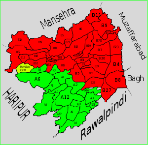 Abbottabad district is divided into two tehsil
s, Abbottabad
and Havelian
as well as one urban administration area – Nawanshehr
.
There are fifty-one Union Councils
in the district, 35 in Abbottabad tehsil and 16 in Havelian. These are:
|-----
| valign="top" |
| valign="top" |
| valign="top" |
|
A
|-----
| valign="top" |
| valign="top" |
|}dobather
{| class="wikitable"
|-
! Constituency
! MPA
! Party
|-
| PF-44 (Abbottabad-1)
| Inayatullah Khan Jadoon
| PML N
|-
| PF-45 (Abbottabad-2)
| Sardar Shamun Ahmed Khan
| PML N
|-
| PF-46 (Abbottabad-3)
| Haji Qalandar Khan Lodhi
| PML Q
|-
| PF-47 (Abbottabad-4)
| Sardar Aurangzeb Khan Nalotha
| PML N
|-
| PF-48 (Abbottabad-5)
| Muhammad Javed Abbasi
| PML N
|}
by two elected MNAs who represent the following constituencies:
{| class="wikitable"
|-
! Constituency
! MNA
! Party
|-
| NA-17 (Abbottabad-I)
| Sardar Mehtab Ahmed Khan Abbasi
| PML-N
|-
| NA-18 (Abbottabad-II)
| Murtaza Javed Abbasi
| PML-N 2nd
|}
, Army Burn Hall College
, Abbottabad Public School
, COMSATS,Peshawar university of Engineering and Technoly Abbottabad campus and Pakistan International Public School among others. The city also hosts a large number of public and private schools and colleges. It hosts the first private medical college for women in Pakistan, Women Medical College, established in 1999. Its literacy rate is higher than national average.
NEW CONCEPT OF LEARNING
galliat metropolitan institute bringing new concept of learning in hazara division with patnership with uk colleges and universities
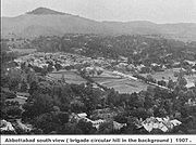
the capital city of the district was founded in 1853 by James Abbott, since then it has been an important military cantonment
and sanatorium
.
at Kohalla Bridge. The region is somewhere between 65 kilometres and 90 kilometres northwest of Islamabad
. "Bakote" means the "land of forts". The Kanhar and Jehlum rivers are the two main rivers in Circle Bakote. Famous hill stations in the area are Miran Jani, Mukeshpuri
, Thandiani, Pather Gali, Ayubia, Khanas Pur and Nathia Gali
. There are an emerging tourist point at near New Kohala Bridge on Karair Pull.
, Khairagali, Changlagali and Ghora Dhaka
, is called Ayubia and was named after former President Ayub Khan. The complex is spread over an area of 26 km. The central place has chair lifts.
. Nathiagali is 2493 meter above sea level and is surrounded by mountains.
. "Hullah" is about 2 km east of Thandiani where you can view a part of Muzaffarabad, Pattan sialkot lal.Haweli mohallah jabbri Pattan Kalan, Chamiali, Bandi, Battangi, and Kukmang and other adjioning area. Very beautiful place to visit in the summer time. Thandiani in on the way between Abbottabad and Pattn Kalan. The view of Pattan Kalan and other adjioning area can be seen from "Hullah" and part of Thandiani.
Districts of Pakistan
The Districts of Pakistan are the second order administrative divisions of Pakistan. Districts were the third order of administrative divisions, below provinces and "divisions", until the reforms of August 2000, when "divisions" were abolished...
in the Khyber Pakhtunkhwa province of Pakistan
Pakistan
Pakistan , officially the Islamic Republic of Pakistan is a sovereign state in South Asia. It has a coastline along the Arabian Sea and the Gulf of Oman in the south and is bordered by Afghanistan and Iran in the west, India in the east and China in the far northeast. In the north, Tajikistan...
. The district covers an area of 1,969 km with the city of Abbottabad
Abbottabad
Abbottabad is a city located in the Hazara region of the Khyber Pakhtunkhwa province, in Pakistan. The city is situated in the Orash Valley, northeast of the capital Islamabad and east of Peshawar at an altitude of and is the capital of the Abbottabad District...
being the principal town. Neighbouring districts are Mansehra
Mansehra District
Mansehra District is in the Khyber Pakhtunkhwa province of Pakistan, an area still unofficially known as the Northwest Frontier. Mansehra district and town are named after Man Singh, a leading general of Mughal Emperor Akbar...
to the north, Muzaffarabad
Muzaffarabad District
Muzaffarabad district of Azad Kashmir is located on the banks of the Jhelum and the Neelum rivers, and is very hilly. The district is bounded to Pakistan in the west and to Kupwara and Baramulla districts that comes under the Kashmir section which is part of the greater dispute between India and...
to the east, Haripur
Haripur District
Haripur is a district in the Hazara region of Khyber-Pukhtunkhwa, province of Pakistan with an altitude of around above sea level. Haripur District has the highest Human Development Index of all the districts in the Hazara....
to the west, and Rawalpindi
Rawalpindi District
Rawalpindi is a district of Pakistan in the north of the Punjab province which contains the city of Rawalpindi. The district has an area of . It was part of Rawalpindi Division, until the year 2000 when the division was abolished...
to the south.
History
Origin of name
The district is named after Major James Abbott, the first deputy commissioner of Hazara (1849–1853).Hazara
During British rule Abbottabad became the capital of Hazara division, which was named after and contained the Hazara valley, a small valley in the outermost HimalayasHimalayas
The Himalaya Range or Himalaya Mountains Sanskrit: Devanagari: हिमालय, literally "abode of snow"), usually called the Himalayas or Himalaya for short, is a mountain range in Asia, separating the Indian subcontinent from the Tibetan Plateau...
, between the Indus in the west and Kashmir in the east.
The current Abbottabad District was originally a tehsil
Tehsil
A Tehsil or Tahsil/Tahasil , also known as Taluk and Mandal, is an administrative division of some country/countries of South Asia....
of Hazara, the Imperial Gazetteer of India described it as follows:
As Hazara District
Hazara District
Hazara District was a district of Peshawar Division in the North-West Frontier Province of Pakistan until 1976.The Imperial Gazetteer of India described the district as follows..-Khatris and Khokhran:...
covered a large area, the provincial government decided for administrative purposes to divide Hazara into Abbottabad, Mansehra
Mansehra District
Mansehra District is in the Khyber Pakhtunkhwa province of Pakistan, an area still unofficially known as the Northwest Frontier. Mansehra district and town are named after Man Singh, a leading general of Mughal Emperor Akbar...
, Kohistan
Kohistan District (Pakistan)
Kohistan has two distinct meanings in Pakistan. In Persian "koh" means "peak" and "istaan" means "land of". In its usual modern sense Kohistan District is an administrative district within Pakistan's Khyber-Pakhtunkhwa Province covering an area of 7,492 sq.kilometres; it had a population of...
, Haripur
Haripur District
Haripur is a district in the Hazara region of Khyber-Pukhtunkhwa, province of Pakistan with an altitude of around above sea level. Haripur District has the highest Human Development Index of all the districts in the Hazara....
and Batagram districts. In 1981 Hazara was divided and Abbottabad was formed as a district with two tehsils. In 1981 the total area of District Abbottabad was 3665 square miles (9,492.3 km²) with a population of 977,212. Tehsil Abbottabad (a sub division of the district) – had an area of 1802 square miles (4,667.2 km²) and a population of 667,328 including 51% of Circle Bakote. In 1990 the total population of the district was 1,425,032 including Circle Bakote 43%.
Earthquake of 2005
In October 2005, the district was hit by an earthquake, nine Union Councils were badly hit, these were Dalola, Boi, Balakot, Pattan Kalan, Nambal, Berote, Kukmong, Palak and Beerangali located across the two rivers Jehlum and Kunhar.Demography and society
According to the 1998 census of Pakistan the population of the district was 0.88 million – and according to an estimate this had risen to 1.05 million in 2008.according to hazara gazzeter the main tribes are the DhundDhund
Dhund may refer to:*Dhond Abbasi, a tribe of northern Pakistan.*Dhund - a 1973 Indian film*Dhund - a 2003 Indian film...
s, Tanoli
Tanoli
The Tanoli are a Hazarewal tribe of the Tanawal valley, Hazara region of Khyber Pakhtunkhwa province of Pakistan. Although not usually acknowledged as Pashtuns, the Tanoli have to an extent assimilated many Pashtun cultural features and become Pashtunified. Tribally allied with the Pathans,. The...
s, Awans
Awans
Awans is a Belgian municipality located in the Walloon province of Liège. On January 1, 2006 Awans had a total population of 8,696. The total area is 27.16 km² which gives a population density of 320 inhabitants per km²....
, Jadoon
Jadoon
The Jadoons are one of the largest Pashtun tribes in Pakistan. They originate from Jallalabad and are now located in the southern Hazara Division area of Khyber Pakhtoonkhuwa, Pakistan, partly in Gadoon area in Swabi on the southern slopes of Mahaban Mountains, and partly in Abbottabad District...
s,Kashmiris, shilmani
Shilmani
The Shilmani or Shalmani شلمانى are a Sarbanri Pashtun tribe who are primarily concentrated in the Shalman valley in Khyber agency near Peshawar, North-West Frontier Province, Pakistan, the tribe is also present in different areas of Pakistan and Afghanistan.In Pakistan, they live in Swat, Upper...
, Sarrara
Sarrara
The Sarrara are a tribe found in the Hazara Division of Khyber-Pakhtunkhwa province of Pakistan.-History and origin:They connect themselves with the Dhund Abbasi and the Tanoli tribes, which also found in the Hazara Division. According to of their traditions,they say at some time they came from...
, Karrlals,Qureshi,mughals, Gujjar
Gujjar
The Gurjar are an ethnic group in India, Pakistan and Afghanistan. Alternative spellings include Gurjara, Gujar, Gurjjara and Gūrjara. The spelling Gurjara or Gurjar is preferable to the rest....
s, Syed
Syed
Syed is a masculine given name derived from the title Sayyid, it is not to be confused with the similar looking name Sayid...
and Satti
Parks and protected areas
Under the Khyber Pakhtunkhwa Wildlife (Protection, Preservation, Conservation and Management) Act of 1975, two areas have been designated with the district: Ayubia National ParkAyubia National Park
Ayubia National Park is a protected area of located in Abbottabad District, Khyber Pakhtunkhwa province, northern Pakistan. It was declared a national park in 1984. Ayubia was named after the late Muhammad Ayub Khan , second President of Pakistan...
and Qalanderabad game reserve. Both areas cover only 6% of the landed area of the district.
Neelan Vally
It is part of Mojohan Union Council and is located in an area that was affected by the 2005 earthquake. It is located on Lora Road. The views in this area are quite scenic due to the topography of the land. It is also known locally as the 'Queen of beautiful valleys, along this valley runs the Neelan stream. The origins of this stream are in the Nara Hills through which the streams seems to have cut the valley over time.The natural scenery is highly magnificent. It is actually famous for it scenic beauty, the lush green meadows, deep forests of oak, cedar and pine,vast tracts of unspoiled nature ranging from tropical forest, magnificent waterfalls, fog in Agust/Sept present a glory.In winter snowfall makes scene more attractive and beautiful.Government Of Pakistan Must Should take attention provision of basic infrastructural facilities, namely, good roads, water, electricity, communications and hotels, to centres of attraction, in order to accelerate their development for the purpose of exploiting fully their touristic value. In furtherance of this goal, the appropriate government agency responsible for tourism promotion and development, Must should establish and maintain this close Liaison with other government agencies responsible for the provision of the infrastructure. We would Like the Asian, Europeans and Americas tour companies to having tour offices in this region, It is advisable for the local visitor to make reservation during the holidays and weekends with a particularly busy season. Reservations can be made in Sarbon hotel Abbottabad. You can travel by road from Abbottabad to Havelian City,which is about 45-Min Drive,and visitors coming from Islamabad can travel directly from Hari Pur to Havelian City, where you can make an hour stay for lunch or for refreshment & then to Lora, as restaurants are not aveileble over there due to no development,it is about 40 -Min journey by car from Havelian to heart of queen Nillan vally over well-maintained road.Minerals
Some of the minerals mined within the district are bariteBarite
Baryte, or barite, is a mineral consisting of barium sulfate. The baryte group consists of baryte, celestine, anglesite and anhydrite. Baryte itself is generally white or colorless, and is the main source of barium...
, dolomite
Dolomite
Dolomite is a carbonate mineral composed of calcium magnesium carbonate CaMg2. The term is also used to describe the sedimentary carbonate rock dolostone....
, granite
Granite
Granite is a common and widely occurring type of intrusive, felsic, igneous rock. Granite usually has a medium- to coarse-grained texture. Occasionally some individual crystals are larger than the groundmass, in which case the texture is known as porphyritic. A granitic rock with a porphyritic...
, gypsum
Gypsum
Gypsum is a very soft sulfate mineral composed of calcium sulfate dihydrate, with the chemical formula CaSO4·2H2O. It is found in alabaster, a decorative stone used in Ancient Egypt. It is the second softest mineral on the Mohs Hardness Scale...
, limestone
Limestone
Limestone is a sedimentary rock composed largely of the minerals calcite and aragonite, which are different crystal forms of calcium carbonate . Many limestones are composed from skeletal fragments of marine organisms such as coral or foraminifera....
, magnesite
Magnesite
Magnesite is magnesium carbonate, MgCO3. Iron substitutes for magnesium with a complete solution series with siderite, FeCO3. Calcium, manganese, cobalt, and nickel may also occur in small amounts...
, marble
Marble
Marble is a metamorphic rock composed of recrystallized carbonate minerals, most commonly calcite or dolomite.Geologists use the term "marble" to refer to metamorphosed limestone; however stonemasons use the term more broadly to encompass unmetamorphosed limestone.Marble is commonly used for...
, phosphate
Phosphate
A phosphate, an inorganic chemical, is a salt of phosphoric acid. In organic chemistry, a phosphate, or organophosphate, is an ester of phosphoric acid. Organic phosphates are important in biochemistry and biogeochemistry or ecology. Inorganic phosphates are mined to obtain phosphorus for use in...
, red ochre and red oxide
Hematite
Hematite, also spelled as haematite, is the mineral form of iron oxide , one of several iron oxides. Hematite crystallizes in the rhombohedral system, and it has the same crystal structure as ilmenite and corundum...
.
Subdivisions
Tehsil
A Tehsil or Tahsil/Tahasil , also known as Taluk and Mandal, is an administrative division of some country/countries of South Asia....
s, Abbottabad
Abbottabad
Abbottabad is a city located in the Hazara region of the Khyber Pakhtunkhwa province, in Pakistan. The city is situated in the Orash Valley, northeast of the capital Islamabad and east of Peshawar at an altitude of and is the capital of the Abbottabad District...
and Havelian
Havelian
Havelian is the second largest municipality in Abbottabad District, in what used to be the Hazara District of the Khyber Pakhtunkhwa of Pakistan.-villages:...
as well as one urban administration area – Nawanshehr
Nawanshehr
Nawanshehr is a town in Abbottabad District in Khyber Pakthunkhwa of Pakistan. Nawanshehr's most famous place is Ilyasi Masjid which is the oldest and largest mosque of Abbottabad, there is also a small hill with walking tracks just behind the masjid. The weather is pleasant in summer, so people...
.
There are fifty-one Union Councils
Union Councils of Pakistan
A sherwan or village council in Pakistan is an elected local government body consisting of 21 councillors, and headed by a nazim and a naib nazim...
in the district, 35 in Abbottabad tehsil and 16 in Havelian. These are:
Abbottabad Tehsil
{|mangal|-----
| valign="top" |
- GHUMMAVA
- Abbottabad CentralAbbottabad CentralAbbottabad Central is one of the 51 union councils of Abbottabad District in the Khyber Pakhtunkhwa province of Pakistan. Located in Abbottabad city, the capital of the district, it borders the following union councils: Malikpura Urban to the north and west, by Salhad to the south and by Dhamtour...
- Bagh
- BagnotarBagnotarBagnotar is one of the 51 union councils of Abbottabad District in Khyber-Pakhtunkhwa province of Pakistan. Bagnator is situated on the Abbottabad-Nathi Gali Road some 20 kilometres away from Abbottabad.-Location:...
- BakotBakotBakot is one of the 51 union councils of Abbottabad District in Khyber-Pakhtunkhwa province of Pakistan. It has an average elevation of 645 metres...
- Baldheri
- Banda Pir KhanBanda Pir KhanBanda Pir Khan is one of the 51 union councils of Abbottabad District in Khyber-Pakhtunkhwa, Pakistan.It is located in the north of the district near the border with Mansehra District...
- BeerangaliBeerangaliBeeran Gali is a Union Council of Abbottabad District, in Khyber-Pakhtunkhwa province of Pakistan. located approximately 20 km from Abbottabad city.- History :...
- Berote KalanBerote KalanBirote Kalan or Birote is one of the 51 union councils of Abbottabad District in the Khyber-Pakhtunkhwa province of Pakistan.-Etymology:The name of the union council Birote means the land of wrestlers...
- Boi
- ChamhadChamhadChamad is one of the 51 Union Councils of Abbottabad District in the Khyber Pakhtunkhwa province of Pakistan.- Location :...
- DalolaDalolaDalola is one of the 51 union councils of Abbottabad District in Khyber-Pakhtunkhwa province of Pakistan.- Location :Dalola is located at 34°21'20N 73°23'50E and has an average elevation of 798 metres ....
- Dhamtour
| valign="top" |
- Jarral
- JhangiJhangiJhangi is one of the 51 union councils of Abbottabad District in Khyber-Pakhtunkhwa province of Pakistan. It is also known as Jhangi Syedan and Jhangi Qazia to the local population...
- Kakul Urban
- Kehal UrbanKehal UrbanKehal Urban is one of the 51 union councils of Abbottabad District in Khyber-Pakhtunkhwa province of Pakistan. It is located in the west of the district.-References:...
- KukmangKukmangKukmang is one of the 51 union councils of Abbottabad District in Khyber-Pakhtunkhwa province of Pakistan.- Location :Kukmang is located at 34°16'20N 73°25'30E and has an average elevation of 1208 metres...
- KuthialaKuthialaKuthiala is one of the 51 Union council of Abbottabad District in Khyber-Pakhtunkhwa province of Pakistan.-Subdivisions:Kuthiala Contain nearly 35 small villages i.e..Naka . Nalla .Doga .Jab . Gali Syedian...
- KuthwalKuthwalKuthwal is one of the 51 union councils of Abbottabad District in the Khyber-Pakhtunkhwa province of Pakistan. It is located to the north west of Abbottabad city .- Villages :...
- Malikpura UrbanMalikpura UrbanMalikpura Urban is one of the 51 union councils of Abbottabad District in Khyber-Pakhtunkhwa province of Pakistan. It is located in the west of the district....
- urban
- Mirpur
- Nagri BalaNagri BalaNagri Bala is one of the 51 union councils of Abbottabad District in the Hazara province of Pakistan.- Location :The union council of Nagri Bala is situated in the south central part of Abbottabad District, and lies to the south east of Abbottabad city - the capital city of the district...
- Nambal
- Namli MairaNamli MairaNamli Maira is one of the 51 union councils of Abbottabad District in Khyber Pakhtunkhwa province of Pakistan.- Location :Namli Maira is a mountainous rural area located in Abbottabad District . It takes its name from the two largest hamlets in the Union Council—Namli and Maira...
| valign="top" |
- Nathia GaliNathia GaliNathia Gali or Nathiagali is a mountain resort town or hill station in Hazara, Khyber Pakhtunkhwa, Pakistan. It is a part of the Galiaath which are termed such due to several hill-stations in that area ending with the word "gali", most of which are connected to one other...
- Nawansher UrbanNawansher UrbanNawansher Urban is one of the 51 union councils of Abbottabad District in Khyber-Pakhtunkhwa province of Pakistan . It is located in the north of the district. It is one of the oldest settlement in Abbottabad district....
- PalakPalakPalak is one of the 51 union councils of Abbottabad District in the Hazara province of Pakistan.- Location :Palak is located in the South eastern edge of Abbottabad district...
- Pattan KalanPattan KalanPattan Kalan is one of the 51 union councils of Abbottabad District in Khyber-Pakhtunkhwa province of Pakistan. It lies in an area that was affected by the 2005 earthquake, a total of 27 small camps were set up in Pattan Kalan following the quake.- Location :...
- Pawa
- PhalkotPhalkotPhalkot is one of the 51 union councils of Abbottabad District in Khyber-Pakhtunkhwa province of Pakistan . Most of the people are Awans with the Abbasies in a minority, the Union Council is led by the Nazim Malik Mushtaq Ahmed, most of the people are poor and lead a simple life.- Location :Phalkot...
- Pind Kargu KhanPind Kargu KhanPind Kargo Khan is one of the 51 union councils of Abbottabad District in Khyber-Pakhtunkhwa province of Pakistan it is located 30 km from Abbottabad city.-People, Culture & Economy:...
- SalhadSalhadSalhad is one of the 51 union councils of Abbottabad District in the Khyber-Pakhtunkhwa province of Pakistan.The Union Council of Salhad is named after what was the main village of the area, but has now effectively become a suburb of Abbottabad city.It is situated about two kilometres south of the...
- SarbhanaSarbhanaSarbhana is one of the 51 union councils of Abbottabad District in Khyber-Pakhtunkhwa province of Pakistan .- Location :Sarbhana is located in the west of the district, it is bounded by the following Union Councils, to the north by Kakul, Kuthwal and Beerangali, to the east by Phalkot, to the...
- Sheikh-ul-BandiSheikh-ul-BandiSheikh-ul-Bandi is one of the 51 union councils of Abbottabad District in Khyber-Pakhtunkhwa province of Pakistan. The Union council takes its name from a neighbourhood which is 3 km from the city of Abbottabad. It is in the valley toward the north-west of the Sarban Hills...
- Dobather
- SherwanSherwanSherwan is a Union council of Abbottabad District in Khyber-Pakhtunkhwa province of Pakistan, located 35 km west of Abbottabad.The population of Sherwan Town is over 25000.The local language is Hindko while Urdu is also understood and spoken by local people...
|
A
Havelian Tehsil
{||-----
| valign="top" |
- ChamnakaChamnakaChamnaka is a Modren village in Abbottabad District of Khyber Pakhtunkhwa province of Pakistan. It is part of Mojohan Union Council and is located in an area that was affected by the 2005 earthquake. It is located on Lora Road. The views in this area are quite scenic due to the topography of the...
- Banda Attai KhanBandi Atti KhanBandi Atai Khan is one of the 51 union councils of Abbottabad District in Khyber-Pakhtunkhwa province of Pakistan.- Location :...
- Sajikote
- Hairlan Sharif
- Satora
- Dewal ManalDewal ManalDewal Manal is one of the 51 union councils of Abbottabad District in the Khyber-Pakhtunkhwa province of Pakistan. The main tribe of this Union Council is the Karlal and awan the main subcaste is the Bolakial.-History:...
- Ghari PhulgranGhari PhulgranGarhi Phulgran is one of the 51 union councils of Abbottabad District in Khyber-Pakhtunkhwa province of Pakistan. -Subdivisions:...
- GoreeniGoreeniGoreeni is one of the 51 union councils of Abbottabad District in Khyber-Pakhtunkhwa province of Pakistan.-Location:Goreeni is located in the South of Abbottabad district and forms part of Khyber-Pakhtunkhwa's border with Punjab province where it borders Murree Tehsil of Rawalpindi...
- Havelian UrbanHaveliani UrbanHaveliani Urban is one of the 51 union councils of Abbottabad District in Khyber-Pakhtunkhwa province of Pakistan. It is located in the west of the district....
- JhangraJhangraJhangra is a small town and one of the 51 union councils of Abbottabad District in Khyber-Pakhtunkhwa province of Pakistan. It is located in the south west of the district.-Subdivisions:...
- Langra
- LangrialLangrialLangrial is one of the 51 union councils of Abbottabad District in Khyber-Pakhtunkhwa province of Pakistan. It is located in the south west of the district and borders Haripur District.-Subdivisions:...
| valign="top" |
- Lora
- MojohanMojohanMojohan is one of the 51 union councils of Abbottabad District in Khyber-Pakhtunkhwa province of Pakistan. Mojohan Union Council is located in an area that was affected by the 2005 earthquake. It is located on Lora Road. The views in this area are quite scenic due to the topography of the land...
- Nagri TotialNagri TotialNagri Tutial is one of the 51 union councils of Abbottabad District in Khyber-Pakhtunkhwa province of Pakistan .-Origins of Name:...
- Nara
- PhallahPhallahPhalla Union council takes it name from the chief village in the area. It is one of the most densely populated union councils of Abbottabad District in Khyber-Pakhtunkhwa province of Pakistan....
- Seer GharbiSeer GharbiSeer Gharbi,, is one of the 51 union councils of Abbottabad District in Khyber-Pakhtunkhwa province of Pakistan. It is located in the southeastern part of the province, bordering the Rawalpindi District of Punjab province ....
- Seer Sharqi BhattianSeer Sharqi BhattianSeer Sharqi Mera Rohmal is one of the 51 union councils of Abbottabad District in Khyber-Pakhtunkhwa province of Pakistan . It is located in the south of the district - to the south and east it borders Rawalpindi District, it also borders the following union councils within Abbottabad District, to...
- TajwalTajwalTajwal is one of the 51 union councils of Abbottabad District in Khyber-Pakhtunkhwa province of Pakistan.- Location :Tajwal is located in the south of the district and is in the north western part of Havelian Tehsil, it is bounded by the following union councils, Nathia Gali to the north, Palak to...
naqar qutbaal
- Danna Nooral
- Kiala Paine
- Faqir MohammadThathi Faqir SahibThathi Faqir Sahib is one of the 57 Union Councils of Abbottabad District in Khyber-Pakhtunkhwa province of Pakistan .- Location :The union council of Thathi Faqir Sahib is situated in the North West of Abbottabad district .Thathi Faqir Sahib is 34 km from the city of Abbottabad and is located in a...
- Karhakki
- BodlaBodlaBodla is a Punjabi tribe found along the banks of the Sutlej River in Pakistan.- History and origin :The Bodla are found in the lower and middle Sutlej valley in Pakistan. They were at one time an entirely pastoral tribe, and are said to have come from Multan through Bahawalpur to Sahiwal...
|}dobather
Provincial assembly
The district is represented in the provincial assembly by five elected MPAs who represent the following constituencies:{| class="wikitable"
|-
! Constituency
! MPA
! Party
|-
| PF-44 (Abbottabad-1)
| Inayatullah Khan Jadoon
| PML N
|-
| PF-45 (Abbottabad-2)
| Sardar Shamun Ahmed Khan
| PML N
|-
| PF-46 (Abbottabad-3)
| Haji Qalandar Khan Lodhi
| PML Q
|-
| PF-47 (Abbottabad-4)
| Sardar Aurangzeb Khan Nalotha
| PML N
|-
| PF-48 (Abbottabad-5)
| Muhammad Javed Abbasi
| PML N
|}
National assembly
The district is represented in the National AssemblyNational Assembly of Pakistan
The National Assembly of Pakistan is the lower house of the bicameral Majlis-e-Shura, which also compromises the President of Pakistan and Senate . The National Assembly and the Senate both convene at Parliament House in Islamabad...
by two elected MNAs who represent the following constituencies:
{| class="wikitable"
|-
! Constituency
! MNA
! Party
|-
| NA-17 (Abbottabad-I)
| Sardar Mehtab Ahmed Khan Abbasi
| PML-N
|-
| NA-18 (Abbottabad-II)
| Murtaza Javed Abbasi
| PML-N 2nd
|}
Election 2008
With the announcement by the Election commission of Pakistan that elections would be held on the 8th January, 2008 more than a dozen candidates filed their nomination papers in Abbottabad.Political Campaigns
Abbottabad was the centre of the Sooba Hazara movement that started after national assembly passed 18th amendment to change the name of province from North West Frontier Province (NWFP) or Sarhad to Khyber Pakhtunkhwa. The former govenor of the province has been vocal in this opposition to the new nameEducation
Abbottabad is home of some of the best educational institutes of the country, including Ayub Medical CollegeAyub Medical College
Ayub Medical College is one of several medical schools affiliated to Khyber Medical University located in Abbottabad, Khyber-Pakhtunkhwa, Pakistan. As of January 2011, AMC is home to 1350 students in the MBBS and BDS programs. The school has a large and experienced faculty to support its...
, Army Burn Hall College
Army Burn Hall College
Army Burn Hall College is situated in Abbottabad, Pakistan. There are separate wings for boys and girls. The girls section is located on Mall Road near the city center, the boys branch is in Mandian. Originally these were Junior Burn Hall and Senior Burn Hall Schools respectively...
, Abbottabad Public School
Abbottabad Public School
Abbottabad Public School, or APS or Railway Public School, is a public, all boys, boarding school for 7th to 12th grade students, located in Abbottabad, Pakistan...
, COMSATS,Peshawar university of Engineering and Technoly Abbottabad campus and Pakistan International Public School among others. The city also hosts a large number of public and private schools and colleges. It hosts the first private medical college for women in Pakistan, Women Medical College, established in 1999. Its literacy rate is higher than national average.
NEW CONCEPT OF LEARNING
galliat metropolitan institute bringing new concept of learning in hazara division with patnership with uk colleges and universities
- Khanka Mahboobabad Shareef Havelian
- Ilyasi Masjid
- Thandiyani
- Harnounee
- Shimla hill
- Galyaat
- Havelian Railway Station
- Neelan Velly
- Sajikote
- Hairlan
- Satora
Abbottabad
AbbottabadAbbottabad
Abbottabad is a city located in the Hazara region of the Khyber Pakhtunkhwa province, in Pakistan. The city is situated in the Orash Valley, northeast of the capital Islamabad and east of Peshawar at an altitude of and is the capital of the Abbottabad District...
the capital city of the district was founded in 1853 by James Abbott, since then it has been an important military cantonment
Cantonment
A cantonment is a temporary or semi-permanent military or police quarters. The word cantonment is derived from the French word canton meaning corner or district, as is the name of the Cantons of Switzerland. In South Asia, the term cantonment also describes permanent military stations...
and sanatorium
Sanatorium
A sanatorium is a medical facility for long-term illness, most typically associated with treatment of tuberculosis before antibiotics...
.
Bakote Circle
Bakote Circle or proposed Tehsil is a cluster of Union Councils in the eastern part of Abbottabad District in the Khyber Pakhtunkhwa province of Pakistan. Bakote Circle is located on the upper and west bank of the Jhelum RiverJhelum River
Jehlum River or Jhelum River , ) is a river that flows in India and Pakistan. It is the largest and most western of the five rivers of Punjab, and passes through Jhelum District...
at Kohalla Bridge. The region is somewhere between 65 kilometres and 90 kilometres northwest of Islamabad
Islamabad
Islamabad is the capital of Pakistan and the tenth largest city in the country. Located within the Islamabad Capital Territory , the population of the city has grown from 100,000 in 1951 to 1.7 million in 2011...
. "Bakote" means the "land of forts". The Kanhar and Jehlum rivers are the two main rivers in Circle Bakote. Famous hill stations in the area are Miran Jani, Mukeshpuri
Mukeshpuri
Mukeshpuri or Moshpuri is a high mountain in the Nathiagali Hills, in the Abbottabad District of the Khyber Pakhtunkhwa province in northern Pakistan. It is north of Islamabad, just above Dunga Gali in the Nathiagali area of Ayubia National Park...
, Thandiani, Pather Gali, Ayubia, Khanas Pur and Nathia Gali
Nathia Gali
Nathia Gali or Nathiagali is a mountain resort town or hill station in Hazara, Khyber Pakhtunkhwa, Pakistan. It is a part of the Galiaath which are termed such due to several hill-stations in that area ending with the word "gali", most of which are connected to one other...
. There are an emerging tourist point at near New Kohala Bridge on Karair Pull.
Ayubia Chair Lifts
Ayubia is 38 km east of Abbottabad. A cluster of four small hill stations of KhanspurKhanspur
Khanspur is one of the tourist mountain resort towns of the Galyat area of Pakistan. Khanspur is a settlement in the Ayubia area and is located in Abbottabad District in Khyber Pakhtunkhwa province of Pakistan...
, Khairagali, Changlagali and Ghora Dhaka
Ghora Dhaka
Ghora Dhaka, also known as Ghora Dakka, is one of the tourist mountain resort towns of the Galyat area in northeast Pakistan. It is part of the Ayubia area and is located in the Abbottabad District in the province of Khyber Pakhtunkhwa. It is located at 34°1'49N 73°24'30E and has an altitude of...
, is called Ayubia and was named after former President Ayub Khan. The complex is spread over an area of 26 km. The central place has chair lifts.
Dungagali
Dungagali is a small resort situated on the slopes of the Mukshpuri hill (2,376 m). It commands a view of a series of wooded spurs projecting towards the river Jhelum on the western side. From Dungagali one can climb the 2,813 metres peak of Mukhshpuri, which is the highest point in the range. Natural springs abound on the slopes. It is 34 km from Abbottabad.Nathiagali
Nathiagali is clad in pine, walnut, oak and maple trees. It can be approached both from Murree and Abbottabad. It is 32 km from Abbottabad as well as from MurreeMurree
Murree city is a popular hill station and a summer resort, especially for the residents of Rawalpindi/Islamabad, and for the cities of the province of Punjab, Pakistan...
. Nathiagali is 2493 meter above sea level and is surrounded by mountains.
Thandiani
Thandiani meaning “cold” in the local language, It is one of the highest places of district Abbottabad at an altitude of 2,700 m. It is 31 km from Abbottabad City. The drive takes more or less 80 minutes from Abbottabad with lovely views on both sides of the road. The road rises more than 1,219 metres above Abbottabad. En route from Abbottabad (23 km), the main settlement is the village of KalapaniKala Pani (Pakistan)
Kala Pani is a village in Abbottabad District of Khyber-Pakhtunkhwa, Pakistan. It is located 12km from Abbottabad city on the Abbottabad-Thandiani Road at 34°12'30N 73°19'20E and at an altitude of 1762 metres...
. "Hullah" is about 2 km east of Thandiani where you can view a part of Muzaffarabad, Pattan sialkot lal.Haweli mohallah jabbri Pattan Kalan, Chamiali, Bandi, Battangi, and Kukmang and other adjioning area. Very beautiful place to visit in the summer time. Thandiani in on the way between Abbottabad and Pattn Kalan. The view of Pattan Kalan and other adjioning area can be seen from "Hullah" and part of Thandiani.