

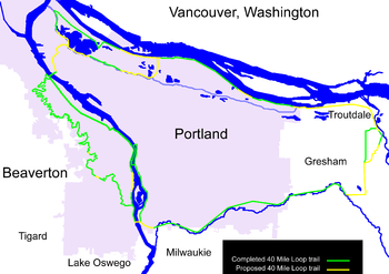
40 Mile Loop
Encyclopedia
Portland, Oregon
Portland is a city located in the Pacific Northwest, near the confluence of the Willamette and Columbia rivers in the U.S. state of Oregon. As of the 2010 Census, it had a population of 583,776, making it the 29th most populous city in the United States...
in the U.S. State
U.S. state
A U.S. state is any one of the 50 federated states of the United States of America that share sovereignty with the federal government. Because of this shared sovereignty, an American is a citizen both of the federal entity and of his or her state of domicile. Four states use the official title of...
of Oregon
Oregon
Oregon is a state in the Pacific Northwest region of the United States. It is located on the Pacific coast, with Washington to the north, California to the south, Nevada on the southeast and Idaho to the east. The Columbia and Snake rivers delineate much of Oregon's northern and eastern...
. It was proposed in 1903 by the Olmsted Brothers
Olmsted Brothers
The Olmsted Brothers company was an influential landscape design firm in the United States, formed in 1898 by stepbrothers John Charles Olmsted and Frederick Law Olmsted, Jr. .-History:...
architecture firm as part of the development of Forest Park
Forest Park (Portland)
Forest Park is a public municipal park in the Tualatin Mountains west of downtown Portland, Oregon, United States. Stretching for more than on hillsides overlooking the Willamette River, it is one of the country's largest urban forest reserves...
.
One greenway expert calls it "one of the most creative and resourceful greenway projects in the country."
The name's "forty" was obsolete within a few decades after it was proposed. The proposed total path is now about 140 miles (225.3 km) long, and connects more than thirty city parks. Similarly, "loop" is not entirely accurate. There are several subloops, cutoffs and spur trails within the system. One spur is proposed to connect to the Pacific Crest Trail
Pacific Crest Trail
The Pacific Crest Trail is a long-distance mountain hiking and equestrian trail on the Western Seaboard of the United States. The southern terminus is at the California border with Mexico...
.
History
Lewis and Clark Centennial Exposition
The Lewis and Clark Centennial Exposition, commonly also known as the Lewis and Clark Exposition, and officially known as the Lewis and Clark Centennial American Pacific Exposition and Oriental Fair, was a worldwide exposition held in Portland, Oregon, United States in 1905 to celebrate the...
of 1905, the city of Portland invited the Olmsted Brothers
Olmsted Brothers
The Olmsted Brothers company was an influential landscape design firm in the United States, formed in 1898 by stepbrothers John Charles Olmsted and Frederick Law Olmsted, Jr. .-History:...
in 1903. Besides suggestions for Washington Park, their research of existing city parks resulted in a bold proposal for a loop of interconnected parks around the city, instead of a traditional plan of scattered parks: "A connected system of parks and parkways is manifestly far more complete and useful than a series of isolated parks." As the brothers puzzled over a name for the system, one asked the other "What would you call a forty-mile loop?" The firm was famous for its straightforward names, so they left it at that.
Little action occurred until a $1 million city bond measure in 1907 passed, which was used to develop existing parks. In 1912, another city planner, Edward H. Bennett
Edward H. Bennett
Edward Herbert Bennett was an architect and city planner best known for his co-authorship of the 1909 Plan of Chicago.-Biography:Bennett was born in Bristol, England in 1874, and later moved to San Francisco with his family...
, also recommended developing a ridgetop park long the West Hills
Tualatin Mountains
The Tualatin Mountains are a range of hills on the western border of Multnomah County, Oregon, United States...
. A $2 million bond issue to acquire the necessary land was voted down. However, shortly afterward, most of the lots sold in Forest Park forfeited to the city or Multnomah County due to high assessments for road building, and a landslide.
In 1943, influential urban planner Robert Moses
Robert Moses
Robert Moses was the "master builder" of mid-20th century New York City, Long Island, Rockland County, and Westchester County, New York. As the shaper of a modern city, he is sometimes compared to Baron Haussmann of Second Empire Paris, and is one of the most polarizing figures in the history of...
was hired, and recommended establishing Forest Park. After several subsequent years of controversy, the park was created in 1948 from tax-delinquent lands, gifts, and purchases. This contained the first portion of the 40 miles (64.4 km) loop.
Little more happened until 1978: at the request of Oregon legislators, U.S. Congress stripped the Columbia Slough
Columbia Slough
The Columbia Slough is a narrow waterway, about long, in the floodplain of the Columbia River in the U.S. state of Oregon. From its source in the Portland suburb of Fairview, the Columbia Slough meanders west through Gresham and Portland to the Willamette River, about from the Willamette's...
of its "navigable" status, enabling the land to be dedicated to recreational use, an important component of the Olmsted plan. The Oregon director of the Nature Conservancy responded to withering federal funds for parks and natural areas by reviving the loop plan to enthusiastic receptions by the City, suburban cities, federal agencies, conservationists, and civic groups. The alliance eventually formed the 40-Mile Loop Land Trust which proved most effective at getting the thirteen key governmental entities—which normally did not talk to each other—to effectively work together. It also served as an intermediary to transfer property from one entity to the other.
One of the Land Trust's major victories was bringing Southern Pacific and Union Pacific railroads together, which jointly owned the abandoned Springwater Corridor
Springwater Corridor
The Springwater Corridor Trail is a bicycle and pedestrian rail trail in the Portland metropolitan area in Oregon, United States. It follows a former railway line of the same name in its route from Boring, through Gresham, to Portland, where it ends near the Eastbank Esplanade. A large segment...
, to transfer the land in 1990 to the Trust. It represented significant progress in the completion of the loop.
Trail
The trail has a variety of sections: some are on level ground, such as along the Columbia RiverColumbia River
The Columbia River is the largest river in the Pacific Northwest region of North America. The river rises in the Rocky Mountains of British Columbia, Canada, flows northwest and then south into the U.S. state of Washington, then turns west to form most of the border between Washington and the state...
; others are heavily forested and/or mountainous, as through Washington Park's Hoyt Arboretum
Hoyt Arboretum
The Hoyt Arboretum is located atop a ridge in the west hills of Portland, Oregon, United States. It was founded in 1922 by a collection of timber industry representatives, the U.S...
. All portions are suitable for walking and hiking, and most are open to bicycling. There are opportunities for strollers, wheelchairs, skating, skateboarding, horseback riding, canoeing, and kayaking.
Route highlights

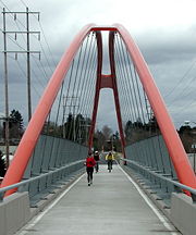
- St. Johns BridgeSt. Johns BridgeThe St. Johns Bridge is a steel suspension bridge that spans the Willamette River in Portland, Oregon, USA, between the St. Johns neighborhood and the northwest industrial area around Linnton. It is the only suspension bridge in the Willamette Valley and one of three public highway suspension...
- Kelley Point ParkKelley Point ParkKelley Point Park is a city park in north Portland in the U.S. state of Oregon. Bounded by the Columbia Slough on the south, the Willamette River on the west, and the Columbia River on the north, the park forms the tip of the peninsula at the confluence of the rivers...
- N. and NE Marine Drive along the south bank of the Columbia RiverColumbia RiverThe Columbia River is the largest river in the Pacific Northwest region of North America. The river rises in the Rocky Mountains of British Columbia, Canada, flows northwest and then south into the U.S. state of Washington, then turns west to form most of the border between Washington and the state...
- Smith and Bybee Wetlands Natural AreaSmith and Bybee Wetlands Natural AreaSmith and Bybee Wetlands Natural Area is a public park and nature reserve between the Columbia Slough and the Columbia River in Portland, Oregon. At about , it is one of the largest urban freshwater wetlands in the United States. Metro, the regional government for the Oregon part of the Portland...
- Columbia SloughColumbia SloughThe Columbia Slough is a narrow waterway, about long, in the floodplain of the Columbia River in the U.S. state of Oregon. From its source in the Portland suburb of Fairview, the Columbia Slough meanders west through Gresham and Portland to the Willamette River, about from the Willamette's...
- Blue Lake Park
- Troutdale, OregonTroutdale, OregonTroutdale is a city in Multnomah County, Oregon, north of Gresham and east of Wood Village. As of the 2010 census, the city population was 15,962....
- Mount Hood Community CollegeMount Hood Community CollegeMt. Hood Community College is a public community college in Gresham, Oregon, United States, named after Mount Hood. Opened in 1966, MHCC enrolls nearly 26,000 students each year and offers classes at the main campus in Gresham, the MHCC Maywood Park Center, and evening education centers at area...
- Gresham, OregonGresham, Oregon- Demographics :As of the census of 2000, there were 90,205 people, 33,327 households, and 22,695 families residing in the city. The population density was 4,071.6 people per square mile . There were 35,309 housing units at an average density of 1,593.8 per square mile...
- Springwater CorridorSpringwater CorridorThe Springwater Corridor Trail is a bicycle and pedestrian rail trail in the Portland metropolitan area in Oregon, United States. It follows a former railway line of the same name in its route from Boring, through Gresham, to Portland, where it ends near the Eastbank Esplanade. A large segment...
- Gresham Main City Park
- Gresham Butte
- Powell Butte Nature Park
- Leach Botanical GardenLeach Botanical GardenLeach Botanical Garden is a botanical garden located in outer southeast Portland, Oregon. The garden will expand by in late 2010 or early 2011....
- Tideman Johnson Natural AreaTideman Johnson Natural AreaTideman Johnson Natural Area is a city park of about in southeast Portland, in the U.S. state of Oregon. Located at Southeast 37th Avenue and Tenino Street along Johnson Creek, the site is named for a mid-19th century family named Johnson that encouraged public use of its land along the...
- Sellwood ParkSellwood ParkSellwood Park is a city park of about in southeast Portland, in the U.S. state of Oregon. Located at Southeast Seventh Avenue and Miller Street, the park includes courts for tennis and basketball; fields for soccer, baseball, softball, and football; picnic areas; a horseshoe pit; a playground;...
- Sellwood Riverfront ParkSellwood Riverfront ParkSellwood Riverfront Park is a city park of about in southeast Portland, in the U.S. state of Oregon. Located at Southeast Spokane Street and Oaks Parkway, the park has paths, picnic tables, a stage, a boat dock on the Willamette River, restrooms, and a dog off-leash area.Formerly a mill site...
- Oaks Amusement ParkOaks Amusement ParkOaks Park is a small amusement park located south of downtown Portland, Oregon USA, near the Sellwood Bridge. The park includes midway games, about two dozen rides that operate seasonally, a skating rink that is open all-year, and picnic grounds.- Rides :...
- Oaks Bottom Wildlife RefugeOaks Bottom Wildlife RefugeOaks Bottom Wildlife Refuge is a city park of about in southeast Portland, in the U.S. state of Oregon. Located in a floodplain along the east bank of the Willamette River near Sellwood, the park is known for attracting a wide variety of birds...
- Eastbank EsplanadeEastbank EsplanadeThe Eastbank Esplanade is a pedestrian and bicycle path along the east shore of the Willamette River in Portland, Oregon, United States...
- Hawthorne BridgeHawthorne BridgeThe Hawthorne Bridge is a truss bridge with a vertical lift that spans the Willamette River in Portland, Oregon, joining Hawthorne Boulevard and Madison Street. It is the oldest vertical-lift bridge in operation in the United States and the oldest highway bridge in Portland...
- Steel BridgeSteel BridgeThe Steel Bridge is a through truss, double lift bridge across the Willamette River in Portland, Oregon, United States. Its lower deck carries railroad and bicycle/pedestrian traffic, while the upper deck carries road traffic and light rail , making the bridge one of the most multimodal in the world...
- I-205 Bike PathI-205 Bike PathThe I-205 Bike Path is a bicycle and pedestrian trail running along Interstate 205 from Vancouver, Washington to Oregon City, Oregon, United States. It parallels the highway and the I-205 Transitway. It has a paved surface...
- Sellwood BridgeSellwood BridgeThe Sellwood Bridge is a truss bridge that spans the Willamette River in Portland, Oregon, in the United States. It was Portland's first fixed-span bridge and, being the only river crossing for miles in each direction, is the busiest two-lane bridge in Oregon...
- Willamette GreenwayWillamette GreenwayThe Willamette River Greenway Program, established by the 1967 Oregon legislature, is a cooperative state and local government effort to maintain and enhance the scenic, recreational, historic, natural and agricultural qualities of the Willamette River and its adjacent lands...
- Willamette ParkWillamette ParkWillamette Park is a city park of about in southwest Portland, in the U.S. state of Oregon. Located at Southwest Macadam Avenue and Nebraska Street, the park includes a boat dock and ramp, paved and unpaved paths, picnic areas, restrooms, a dog off-leash area, playground, soccer field, and tennis...
- South WaterfrontSouth WaterfrontThe South Waterfront is a high-rise district under construction on former brownfield industrial land in the South Portland neighborhood south of downtown Portland, Oregon, U.S. It is one of the largest urban redevelopment projects in the United States...
- Willamette Park
- Wildwood Trail
- Washington Park
- Hoyt ArboretumHoyt ArboretumThe Hoyt Arboretum is located atop a ridge in the west hills of Portland, Oregon, United States. It was founded in 1922 by a collection of timber industry representatives, the U.S...
- Hoyt Arboretum
- Pittock MansionPittock MansionThe Pittock Mansion is a French Renaissance-style "château" in the West Hills of Portland, Oregon, USA, originally built as a private home for The Oregonian publisher Henry Pittock and his wife, Georgiana. It is a 22 room estate built of Tenino Sandstone situated on that is now owned by the...
- Forest ParkForest Park (Portland)Forest Park is a public municipal park in the Tualatin Mountains west of downtown Portland, Oregon, United States. Stretching for more than on hillsides overlooking the Willamette River, it is one of the country's largest urban forest reserves...
- Audubon Society of PortlandAudubon Society of PortlandThe Audubon Society of Portland is a non-profit environmental organization dedicated to wildlife conservancy in Portland, Oregon, U.S.Founded in 1902 and incorporated in 1909, it is one of the oldest such organizations in the world....
- Washington Park